
Where Flight Simulation Enthusiasts Gather from Around the World!
AVSIM Library - Search Results

| Category: Flight Simulator X - Scenery | |
| Yeu island - LFEY |

|
Images related to this file:
File Description:
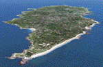
The island of Yeu (LFEY) is located in the west of France, in the south-west of Nantes. Its main runway is located on the wild coast, near the great lighthouse.
It is made up of :
- A new mesh based ASTER compiled in LOD11 and a very local mesh for the airport, compiled in LOD13 to get a good compatibility with the specific payware meshes.
- Photorealistic texture at 0.5 m/pixel based on aerial photography.
- The airfield and runway. The runway is flat, allowing to preserve the AI traffic. The grass strip is modeled with its relief. There is therefore no AI traffic on the grass strip.
- The port of Port-Joinville and several notable buildings made with Gmax (churches, chapel, castle, fort, ruins, beacons, etc)
- Generic or custom objects created with Gmax (boats, buildings).
| Filename: | Yeu_island__LFEY.zip |
| License: | Freeware |
| Added: | 29th December 2012, 04:03:47 |
| Downloads: | 1,717 |
| Author: | marc guitteny |
| Size: | 217.78 MB |
| Category: Flight Simulator 2004 - Scenery | |
| US North Cascades Mountains and Northwest Washington Coast |
|
File Description:
The files in this package completely replace the FS default landscape of the North Cascades Mountains and coastal areas of northwestern Washington State. Between Bellingham and Arlington (N-S), Orcas Island and Lake Chelan (W-E) you can now enjoy your VFR flights with accurate locations of coastlines, lakes, rivers, streams, roads, railroads, and power lines, as well as land use type (landclass) and terrain (add-on mesh). Also added are the larger glaciers of the majestic North Cascades volcanoes and peaks as well as several forestry roads and clearcuts outside the National Park and Wilderness areas. Made mostly with Christian Fumey's "Ground2K4" and Jim Keir's "Slartibartfast". Fully compatible with the recent freeware LOD10 add-on meshes of the western US. Mesh and landclass files will work in FS2002 but not the special scenery enhancements.
| Filename: | US_North_Cascades_Mountains_and_Northwest_Washingt.zip |
| License: | Freeware, limited distribution |
| Added: | 18th May 2004, 23:12:57 |
| Downloads: | 14,319 |
| Author: | Holger Sandmann |
| Size: | 12.72 MB |
| Category: Flight Simulator 2004 - Scenery | |
| Glacier Bay National Park, Alaska |
|
File Description:
Add-on meshes can greatly improve the detail of the FS terrain but often conflict with the inaccurate placement of the other default FS landscape elements, particularly in coastal and mountainous areas. This project showcases new methods and software that allow for semi-automated development of FS landscapes from accurate source data. The files completely replace the default FS landscape of Southeast Alaska's Glacier Bay National Park and the adjacent Lynn Canal area between Juneau and Skagway (N58-60 W134-138), including shorelines, islands, and lakes, as well as glaciers, landclass, man-made features, and a LOD9 (76-m) terrain mesh. Optional AI floatplane traffic at four seaplane bases is included. A LOD10 (38-m) mesh of the same area is available as a separate optional download. FS2002 users please use fs8glbay.zip instead.
| Filename: | Glacier_Bay_National_Park_Alaska.zip |
| License: | Freeware, limited distribution |
| Added: | 16th February 2004, 03:40:31 |
| Downloads: | 17,192 |
| Author: | Holger Sandmann, Jim Keir |
| Size: | 10.43 MB |
| Category: Flight Simulator 2004 - Scenery | |
| Altitude adjustment for Dawson City CYDA |
|
Images related to this file:
File Description:
I discovered that the Northern Canada Terrain Mesh that I installed a while back was dumping part of my Dawson City Airport CYDA into a deep hole. I tried making a flatten to reduce the height of the terrain mesh land but that did not look at all realistic. So, the solution is to raise CYDA to 1,457 feet above sea level instead of the correct (correct according to the Nav Canada Supplement) level of 1,215 feet so that it melts into the surrounding terrain. There are still some rocky faces but at least they are not in the airfield. Do you need it? Not if your version looks ok. If it doesn't look ok then try this, but save your current version so you can go back to it if you need to.
| Filename: | Altitude_adjustment_for_Dawson_City_CYDA.zip |
| License: | Freeware, limited distribution |
| Added: | 23rd July 2019, 17:24:26 |
| Downloads: | 103 |
| Author: | Roger Wensley |
| Size: | 855.58 KB |
| Category: Flight Simulator 2002 - Scenery | |
| Alaska Bush Scenery: Coghill Lake |
|
File Description:
Situated off College Fiord at the upper end of Prince William Sound, Coghill Lake is conveniently positioned for stopping off en-route between the Anchorage & Valdez areas. It's the actual location of a holiday cabin owned by the US Forest Service which can only be reached by floatplane, however I've added 2 airstrips to the area for extra interest. Coghill's main landing strip is sandy & partially overgrown, but has a good available length of 635m/2100' and some low-intensity edge lights. Ample parking for visitors is provided in a separate ramp area amongst the trees, reached via a basic but lit & signposted taxiway. Adjacent access by floatplane is possible using the small lagoon, as well as by College Fiord itself for larger loads. The other strip, a mile southwest across the river, only gets seasonal use by agricultural aircraft for spraying the local conifer plantations; its narrow gravel runway is slightly shorter at 588m/1930' & is a more challenging proposition with the surrounding trees and heavy brush all encroaching on the landing strip. Includes 2 versions: 1 for Eddie Denney's FS2002 mesh (recommended as this makes the airstrip profiles uneven), and another for both Eddie Denney's FS2000 mesh and the default mesh.
| Filename: | Alaska_Bush_Scenery_Coghill_Lake.zip |
| License: | Freeware, limited distribution |
| Added: | 28th May 2003, 19:07:22 |
| Downloads: | 1,933 |
| Author: | James Belk |
| Size: | 2.98 MB |
| Category: Flight Simulator 2004 - Scenery | |
| Igloolik CYGT update (to FSGenesis 76m North Canada Terrain Mesh revision) |
|
Images related to this file:
File Description:
These are replacement bgl's and textures to correct the already posted Igloolik CYGT for use with the FSGenesis 76m terrain mesh for northern Canada. I noticed after posting that the PAPI were incorrectly positioned, and after fixing that I went on and updated the windsocks, added the wheeled roller/snow clearer that all gravel fields need in the north, and updated the signage to give the true headings for the runway. This is not stand-alone, and the presumption is that you have already downloaded and installed the previously posted scenery. Installation consists solely of replacing the existing scenery bgl's with the new, and adding the new signage textures.Any comments regarding further corrections that are required would be welcomed.
| Filename: | Igloolik_CYGT_update_to_FSGenesis_76m_North_Canada.zip |
| License: | Freeware, limited distribution |
| Added: | 30th September 2017, 20:11:03 |
| Downloads: | 84 |
| Author: | Roger Wensley |
| Size: | 1.03 MB |
| Category: Flight Simulator 2004 - Scenery | |
| Backcountry airfields for 19m terrain mesh in Idaho USA series 2 |
|
Images related to this file:
File Description:
These backcountry fields are for use with the FSGenesis 19m mesh of Idaho; they almost certainly do not work without it. The six airfields are a follow-on series to the previous four, ranging from Stanley that has a village and airfield buildings of one sort or another and even a length of asphalt runway, to Bruce Meadows that has two bathrooms. The full list from northwest to southeast is Bruce Meadows U63, Garden Valley U88, Warm Springs Creek 0U1, Stanley 2U7, Graham U45, and Smiley Creek U87. These airfields compensate for the loss of airfield flattens after the removal of AF917150 and AF917160, but there remain some now-unflattened airfields I have not included here, whether for reason of the impossibility of realistically creating it (as in the case of Flying B) or just a total lack of anything interesting about it. There may be some more follow-on fields that are new, to the north of the original four; these six are all to the south. The landclass files either change forested areas, as in Bruce Meadows, or add a village, as in Stanley. Although these are stand-alone, the presumption is that you have already installed the original four for use with the FS Genesis 19m terrain mesh, and there is a correction for Big Creek where I missed spotting a lack of flatten in one area.
| Filename: | Backcountry_airfields_for_19m_terrain_mesh_in_Idah.zip |
| License: | Freeware, limited distribution |
| Added: | 29th May 2017, 04:20:10 |
| Downloads: | 111 |
| Author: | Roger Wensley |
| Size: | 9.09 MB |
| Category: Prepar3D V5 - Scenery | |
| CVX_ETM12m HPX for ANGOLA vers. 2.0 |
|
Images related to this file:
File Description:
Hydro Polys for lakes and river and coastline.It is imperative to have already installed the ETM12m v2 AO - Enhanced Terrain Mesh 12m v2 for ANGOLA vol.01/02/03/04/05/06/07/08/09/10/11/12. This is a work in progress. This release replace and delete the previous version 1.40 (Please remove it before install new version) .
| Filename: | CVX_ETM12m_HPX_for_ANGOLA_vers_20.zip |
| License: | Freeware |
| Added: | 16th February 2021, 19:59:39 |
| Downloads: | 115 |
| Author: | Giovanni Miduri |
| Size: | 11.82 MB |
| Category: Flight Simulator X - Scenery | |
| CYSV Saglek, New Foundland, Canada |
|
File Description:
This scenery as much as possible represents Saglek (CYSV), located at the north of New Foundland, Canada according to photographs found on the Web. This scenery is compatible with Mesh de M.Gilles Gauthier. Several originators took part in the design of this scenery: Regis Dassylva, Gerald Allaire, Gilles Gauthier and Jean-Pierre Fillion, all members of Concepteurs Virtual du Quebec.
| Filename: | CYSV__Saglek_New_Foundland_Canada.zip |
| License: | Freeware |
| Added: | 4th December 2009, 02:12:36 |
| Downloads: | 1,118 |
| Author: | Regis Dassylva |
| Size: | 8.5 MB |
| Category: Flight Simulator X - Scenery | |
| New Caledonia |
|
Images related to this file:
File Description:
A complete scenery of all islands with:
-New landclass
-New mesh on basis SRTM-v4
-New waterclass
-New layout of banks, roads, rivers
-Limits of the coral barrier.
-Generic objects (pylons, cranes, ships, boats and buildings)
-Airport replaced at its good altitude
-Some remarkable buildings (Djibaou Arts Center, Church, Amedee lighthouse)
-Additional buildings
| Filename: | New_Caledonia.zip |
| License: | Freeware, limited distribution |
| Added: | 12th September 2010, 18:24:47 |
| Downloads: | 3,257 |
| Author: | Marc Guitteny |
| Size: | 26.57 MB |
© 2001-2026 AVSIM Online
All Rights Reserved
Privacy Policy |