
Where Flight Simulation Enthusiasts Gather from Around the World!
AVSIM Library - Search Results

| Category: Flight Simulator 2004 - AFCAD Files | |
| New Zealand Airfields and Airstrips 2 |

|
File Description:
This is the second in the series of making GA aircraft populate small airfield around New Zealand. Improvements have been made to my first existing AFCAD files and now FSE files and flightplans are included for added realism! New airfields included are: NZCX (Coromandel) NZGB (Great Barrier) NZDA (Dargaville) NZUN (Pauanui Beach) Enjoy - as there's lots more to come yet!!!
| Filename: | New_Zealand_Airfields_and_Airstrips_2.zip |
| License: | Freeware |
| Added: | 20th August 2004, 22:25:26 |
| Downloads: | 905 |
| Author: | Doug Stone |
| Size: | 27.11 KB |
| Category: Flight Simulator 2004 - AFCAD Files | |
| Real New Zealand Auckland Airport-NZAA |
|
File Description:
With the release of Robin Corn's Real New Zealand, the photographic scenery of NZAA makes the AFCAD misalligned. This is an attempt to allign as much as I could the runways and taxiways etc. I have tried to duplicate what the real life airport looks like from photos I have. It uses the default airport. Any improvements welcome until we see a fully done GMAX version of this airport.
| Filename: | Real_New_Zealand_Auckland_AirportNZAA.zip |
| License: | Freeware |
| Added: | 13th July 2005, 23:22:40 |
| Downloads: | 897 |
| Author: | Doug Stone |
| Size: | 10.3 KB |
| Category: Miscellaneous Files - Miscellaneous Files | |
| Al Pelletier's Round Robins - New Zealand |
|
File Description:
In this Round Robin, you are flying for the New Zealand Air force and are on Pilot trainer/Round Robin. I have added some very rare charts and maps with this one. The charts and maps are in high resolution, so don’t be scared to zoom on!
| Filename: | Al_Pelletiers_Round_Robins__New_Zealand.zip |
| License: | Freeware, limited distribution |
| Added: | 16th December 2006, 20:25:16 |
| Downloads: | 659 |
| Author: | Al Pelletier |
| Size: | 11.1 MB |
| Category: Flight Simulator 2004 - Scenery | |
| New Zealand SRTM Elevation Mesh LOD9 |
|
File Description:
New Zealand elevation mesh scenery based on SRTM data, LOD9. Includes terrain only and combines with any default or add-on scenery, no *additional* landcover information, coastline definitions or airports. This single ZIP-file includes North and South island and nearby smaller islands (e.g. Chatham Is.).
| Filename: | New_Zealand_SRTM_Elevation_Mesh_LOD9.zip |
| License: | Freeware, limited distribution |
| Added: | 11th July 2004, 04:40:56 |
| Downloads: | 9,228 |
| Author: | Matthias Weidemann |
| Size: | 40.03 MB |
| Category: Flight Simulator X - Scenery | |
| NZWV - Waihi Beach Airfield, New Zealand |
|
Images related to this file:
File Description:
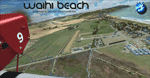
Waihi Beach (ICAO: NZWV) is a small airstrip north of Tauranga and near the small beach settlement of the same name, in the Bay of Plenty of New Zealand. It is a grass strip with offset thresholds giving usable landing lengths of 640m and 517m for RWY 13 and 31 respectively, a width of 55m and a group rating of 5. No night lighting or fuel is available. A very basic airstrip, there is only one recently built hanger and the airstrip is slowly being encroached on by
new housing developments. The airstrip itself is usually very sodden due to its low elevation but is a nice stop over for sightseeing from Tauranga and up the Coromandel peninsula.
The FSX model includes custom textures and models placed on a high resolution aerial image and a 15m mesh. It makes extensive use of items from the free VLC object libraries which are required to be installed (Available from www.vectorlandclass.co.nz Downloads menu). This scenery and
the VLC libraries have been funded by sales of VectorLandClass and although you do not need VLC to use it, your purchase helps further development.
| Filename: | NZWV__Waihi_Beach_Airfield_New_Zealand.zip |
| License: | Freeware, limited distribution |
| Added: | 1st November 2012, 10:01:38 |
| Downloads: | 1,006 |
| Author: | Tim Barnes / VectorLandClass |
| Size: | 11.13 MB |
| Category: Flight Simulator X - Scenery | |
| Wellington Intl and City, New Zealand |
|
File Description:
This Real New Zealand payware scenery is now available as freeware.
Features: Wellington International Airport; Wellington City and greater Wellington area; Photoreal, accurate GMAX-modeled airport; Photoreal aerial images covering 50 x 70 kilometres.
| Filename: | Wellington_Intl_and_City_New_Zealand.zip |
| License: | Freeware, limited distribution |
| Added: | 17th December 2013, 15:52:12 |
| Downloads: | 12,506 |
| Author: | Robin Corn, Godzone Virtual Flight |
| Size: | 264.97 MB |
| Category: Flight Simulator X - AFCAD Files | |
| V2 Christchurch Intl - NZCH - New Zealand |
|
File Description:
ADE Home Edition (Freeware) was used to design these BGL files: This is an update of my previous version, my previous version not required, these 2 files are only for the FSX default airport: one with the Xwind rwy 11/29 activated where both rwy's will now be used for takeoff/landing and one as default: all taxiways now updated to the Nov 07 AIP NZ ground movement charts, all taxisigns changed to match the taxiways with missing taxisigns added, assigned parking with extra parking, and for the Canterbury Aero Club the grass rwy 2L/20R is now open and start locations added, support vehicle roads rebuilt, extra fuel trucks and several other improvements, airport views are from the roof of control tower (when in tower view) fully tested with Ultimate Traffic/WOAI but not required, please view the readme before installation
| Filename: | V2_Christchurch_Intl__NZCH__New_Zealand.zip |
| License: | Freeware |
| Added: | 13th December 2007, 08:34:27 |
| Downloads: | 2,405 |
| Author: | Ray Smith |
| Size: | 17.1 KB |
| Category: Flight Simulator X - Scenery | |
| NZGA- Galatea Aerodrome (VectorLandClass, New Zealand) |
|
Images related to this file:
File Description:

Welcome to Galatea (ICAO: NZGA), a gateway to exploring the Urewera ranges and the east coast of New Zealand. Galatea is a small and basic airstrip with only one old hanger, a public toilet and a small clubhouse on a wide plain surrounded by native bush and pine plantation near Murupara in the Bay of Plenty of New Zealand. It is a grass strip of 1025m length and 60m width and aligned 01/19 with a group rating of 8. No night lighting or fuel is available.
The FSX model includes custom textures and models placed on an aerial image. It makes extensive use of items from the free VLC object libraries which are required to be installed (download from www.vectorlandclass.co.nz downloads menu). This scenery and the VLC libraries have been funded
by sales of VectorLandClass and although you do not need VLC to use it, your purchase helps further development.
To the south west of Murupara township and sawmill is the LakeLand Helicopters base which just fits onto the photo-real coverage. Library objects have been placed here although they may not be accurate as the site was not visited when taking reference photos. This airfield makes a great stop over when flying between Rotorua, Mount Tarawera, Whakatane or Gisborne.
We hope you enjoy exploring the area!
| Filename: | NZGA_Galatea_Aerodrome_VectorLandClass_New_Zealand.zip |
| License: | Freeware, limited distribution |
| Added: | 15th November 2012, 23:35:42 |
| Downloads: | 1,127 |
| Author: | Tim Barnes / VectorLandClass |
| Size: | 45.7 MB |
| Category: Flight Simulator 2004 - Scenery | |
| Dunedin International Airport, New Zealand. NZDN. |
|
File Description:
Welcome to Dunedin International Airport, situated at Momona, 11 nautical miles west of the City of Dunedin, in the Otago region of the South Island of New Zealand.
This scenery will also perfectly fit into the freeware "Dunedin City" photoreal ground textures scenery by Ian Warren. The scenery contains a few small custom items (textures included), but also requires some EZ Scenery Object Sets (see INSTALL instructions for details).
| Filename: | Dunedin_International_Airport_New_Zealand__NZDN.zip |
| License: | Freeware, limited distribution |
| Added: | 10th April 2009, 22:23:11 |
| Downloads: | 1,350 |
| Author: | Lawrie Roache |
| Size: | 2.59 MB |
| Category: Flight Simulator X - Scenery | |
| NZOP- Opotiki Aerodrome (VectorLandClass, New Zealand) |
|
Images related to this file:
File Description:
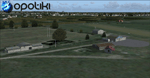
Opotiki aerodrome (ICAO: NZOP) is a small airstrip outside the township of of Opotiki, the gateway to the beautiful East coast of the North Island of New Zealand. Opotiki itself sits at the confluence of the Waioeka and Otara rivers and is surrounded by dairy farmland and Kiwifruit orchards with large areas of native bush to the south and east.
This scenery accompanies Tim Barnes'�� series of other small Bay of Plenty aerodromes (Whakatane,
Galatea, Waihi Beach) for use with VectorLandClass- It features custom modelled and textured buildings, large coverage of beautiful 0.5m aerial photography (fully auto-genned and including seasonal and night variations) and extensive use of high quality objects from the free VLC library. Installation of the library V1.1+ is required for this scenery to work properly and can be downloaded from the VectorLandClass website (www.vectorlandclass.co.nz)
This release, although not requiring it, works best with VectorLandClass topographic mesh and landclass addon covering all 268676 square kilometers of New Zealand. If you'��re not a VLC customer, you'��ll notice when the photoreal coverage runs out!
| Filename: | NZOP_Opotiki_Aerodrome_VectorLandClass_New_Zealand.zip |
| License: | Freeware, limited distribution |
| Added: | 21st February 2013, 13:52:47 |
| Downloads: | 969 |
| Author: | Tim Barnes |
| Size: | 146.68 MB |
© 2001-2026 AVSIM Online
All Rights Reserved
Privacy Policy |