
Where Flight Simulation Enthusiasts Gather from Around the World!
AVSIM Library - Search Results

| Category: Flight Simulator X - Scenery | |
| 3 gps oil platforms addon scenarys from fsxf. For missions. |

|
File Description:
3 GPS oil platforms addon scenarys from FSXF.
All Oil Platforms are in the Gulf of Mecico, They have some ships around them,
FSX-GPS Oil platforms is good for Missions. These are the Mission platforms.
-----------------------------------------------------------------------------------------------
This is for the Layafette oil platform, The airport name is Lafayette Oil Platform.(KLFO) The NDB(none directional beacon) frequency is 477.0,
NDB Range is 100 NM. Layafette Oil platform is 65 NM. South of Layafette Regl. Louisiana-KLFT
-----------------------------------------------------------------------------------------------
This is for the Galveston oil platform, The airport name is Galveston oil platform. (KGLO) The NDB Frequency is 396.0, NDB. range is 100 NM.
Galveston oil platform is 7 NM. South of Scholes Intl. at Galveston Texas-KGLS
---------------------------------------------------------------------------------------------
This is for the Corpus Christi oil platform, The airport name is Corpus Christi oli platform. (KNGO) The NDB Frequency is 391.0. NDB. range is 100 NM.
Corpus Christi oil platform is 7 NM. South of Corpus Christi NAS. Texas-KNGP
------------------------------------------------------------------------------
| Filename: | 3_gps_oil_platforms_addon_scenarys_from_fsxf_For_m.zip |
| License: | Freeware |
| Added: | 4th July 2008, 23:32:50 |
| Downloads: | 1,451 |
| Author: | Timothy T. Marson |
| Size: | 3.35 KB |
| Category: Flight Simulator X - Scenery | |
| CWY9 "Your Own Airport" |
|
File Description:
You download a plane.-----where do you go and fly it ????...
NY...San Francisco, N.O., LA, Rio, Madrid.....Panama??? what a hassle!!!! you have to choose from so many Airports..........
Now you can have Your Very Own Airport....It Includes:
8500 ft Re-enforced Concrete Runway....125ft Wide!!!!!!!!
Taxiways, also Re-enforced Cement of the best quality.
Lighted from Dawn to Dawn!!!!!.....powerful bulbs all around!!!!
Lighted Aprons.....Terminal for your Passangers..a fair Town with good Hotels and around 13 Bars!!!!!!! two have all night Shows!!!!!!very near the terminal, two plush Marinas!!with Hotels and many boats for rent and Sale.....and some crazy traffic to boost!!!!!..This scenery is located in a beautiful cove up north in Canada near all major airports of the West Coast. and its called "YourOwn" ICAO =CWY9.......Oh!! you can land anything here..FREE Parking!!!!!!
Oh Yea...it includes, an AFCAD for your runway, Scenery Galore, and an AircraftCarrier and other ships nearby.....Hummm, Hummmm...................
| Filename: | CWY9__Your_Own_Airport.zip |
| License: | Freeware, limited distribution |
| Added: | 18th November 2008, 18:26:55 |
| Downloads: | 1,436 |
| Author: | Gera Godoy Canova |
| Size: | 4.69 MB |
| Category: Flight Simulator X - Aircraft Repaints, Textures and Modifications | |
| Boeing 747 BDSF GE FlyMeta 9H-WFF operated by Air Atlanta |
|
Images related to this file:
File Description:
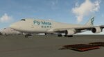
9H-WFF is a BDSF (Bedek Special Freighter) that started life in 1992 as a passenger variant with Japan Airlines on lease from Aersale. Was transferred to Asiana in 2012 under lease as a freighter after conversion by IAI (Israel Aerospace Industries), then leased to Air Atlanta who operate the airframe for FlyMeta, originally with an Icelandic registration of TF-WFF and as of 2026 under a Maltese registration 9H-WFF. As of January 2026 this machine (along with her two FlyMeta sister ships) can be seen operating cargo flights to Europe out of China from VHHH/Hong Kong and ZSHC/Hangzhou to EBLG/Liege and LHBP/Budapest and various central asian locations in between such as OMSJ/Sharjah and OMDW/Dubai World Central.
This repaint is for the Project Opensky (POSKY) 747-400BCF GE-CF6 model and the archive includes textures only, you will need a working copy of the model, sounds and panel, all of which can be found here at avsim.com
| Filename: | Boeing_747_BDSF_GE_FlyMeta_9HWFF_operated_by_Air_A.zip |
| License: | Freeware |
| Added: | 16th February 2026, 12:40:33 |
| Downloads: | 27 |
| Author: | Dean Stringer |
| Size: | 8.29 MB |
| Category: Flight Simulator 2004 - Scenery | |
| Ocean Stations Scenery |
|
File Description:
I've produced this scenery to provide all of the Ocean Stations I know about in the 1950's and 1960's. There is a ship on station (painted in the colors of the USA, UK, France, Norway, and Japan), an NDB to give you a bearing to the ship, a way to contact the ship using voice (you can get your position relative to the ship this way), and a DME for distances further than the limited 30 NM FS ATC gives you (normal communications would reach about 100 NM). You can also get a weather report, and if you are a seaplane you can be cleared to land. If you are a landplane, I guess this would constitute permission to ditch...
I want to give a big thank you to Mitsuya Hamaguchi (hama) for graciously supplying the ship used in this scenery.
This version uses AI ships and is NOT COMPATIBLE with multiplayer - use OceanStationsMP.zip instead
| Filename: | Ocean_Stations_Scenery.zip |
| License: | Freeware, limited distribution |
| Added: | 6th May 2008, 03:51:41 |
| Downloads: | 3,568 |
| Author: | Tom Gibson |
| Size: | 1.02 MB |
| Category: Flight Simulator 2004 - Scenery | |
| CYCQ - Chetwynd - British Columbia, Canada |
|
Images related to this file:
File Description:
The town of Chetwynd (population around 2,600) is on the east side of the Rocky Mountains, the first town to be encountered when descending from the Rockies on highway 97. Previously known as Little Prairie, the town name was changed in 1962. The main occupations of the town are linked to forestry, fossil fuels, and transportation; there are railway lines north to Fort St John, east to Dawson Creek, and south to Prince George. The airport is on the southern side of the town, with one runway aligned 05-23, asphalted in 1975 and just under 4,500 feet long. There are no scheduled services, although a new terminal building was constructed in 2008, and the helicopter operations by at least two companies (oil and gas and medical evacuation flights) are the primary operations from the field. These are included in the AI, incorporating helicopter modifications made by Holger Sandmann so that they function properly as AI at an airfield. As an aside, landing like a plane and using the runway and taxiways is in fact exactly what a helicopter does at a normal airfield in real life; everyone does the same thing so that guessing is unneccesary.
| Filename: | CYCQ__Chetwynd__British_Columbia_Canada.zip |
| License: | Freeware, limited distribution |
| Added: | 28th March 2016, 21:36:33 |
| Downloads: | 298 |
| Author: | Roger Wensley |
| Size: | 18.84 MB |
| Category: Flight Simulator 2004 - Scenery | |
| Colorado Lakes Project II |
|
File Description:
This project features the Blue Mesa Reservoir and the Black Canyon of the Gunnison and adds over 300 highly detailed lakes to the central portion of western Colorado. Three reservoirs, named for corresponding dams on the Gunnison River, form the heart of Curecanti National Recreation Area. Panoramic mesas, fjord-like reservoirs, and deep, steep and narrow canyons abound. Blue Mesa Reservoir is Colorado's largest body of water, and is the largest Kokanee Salmon fishery in the United States. Morrow Point Reservoir is the beginning of the Black Canyon of the Gunnison and below it is Crystal Reservoir.
These lakes are specifically designed to show off their photo realistic detail when used in combination with "FSGenesis-The Rockies 38.2m Terrain Mesh-Colorado" available as "fsg_dem38m_usrk_co.zip" at avsim.com, or comparable mesh. The free FSGenesis US National Landclass Project Beta 6 also adds beautifully to the landscape. These lakes work equally as well with the default mesh.
All lake information was projected from satellite imagery and compiled with a beta version of Jim Keir's "Slartibartfast" utility. Much thanks to Holger Sandmann and Jim Keir for their help and advice on interpreting the satellite data properly.
| Filename: | Colorado_Lakes_Project_II.zip |
| License: | Freeware |
| Added: | 1st June 2004, 02:34:42 |
| Downloads: | 6,050 |
| Author: | Carlyle Sharpe |
| Size: | 332.25 KB |
| Category: Prepar3D V1-4 - Scenery | |
| Valdez Alaska USA N61.06.53 W146.19.52 and Tatitlek Alaska USA N6052.00 W146.41.37 |
|
File Description:
Valdez Alaska USA N61.06.53 W146.19.52 The town is positioned at the head of a fjord on the eastern side of the Prince William Strait (at the end of the Valdez bay). It is surrounded by the Chugach mountains with many glaciers and peaks up to 2100 m above sea level. Although the northernmost port in North America is free of ice all year round. It is also the northernmost point of the Pacific coastal forest located in the 107-meter hill southwest of the town called Blueberry Hill. Valdez has an ICAO PAVD airport that in the scenario in addition to the city of Valdez you will also find a small village called Tatitlek Alaska USA N6052.00 W146.41.37 with related ICAO 7KA airport airports infrastructures have been improved with the addition of a port for landing ships and seaplanes on Valdez and Tatitlek. Important VFR point for approaching airport and seairport PAVD and 7KA.
Within the downloaded package you will find readme files for scenery installation. Good fly VFR. Pasquale Marrulli.
| Filename: | Valdez_Alaska_USA_N610653_W1461952_and_Tatitlek_Al.zip |
| License: | Freeware |
| Added: | 21st May 2018, 22:35:56 |
| Downloads: | 230 |
| Author: | Pasquale Marrulli |
| Size: | 3.27 MB |
| Category: Flight Simulator 2004 - Aircraft Repaints, Textures and Modifications | |
| Dutch Navy Lockheed PV-2 Harpoon |
|
Images related to this file:
File Description:
Featured is Royal Netherlands Navy 19-10, ex-US Navy BuNo 37260, Lockheed c/n 15-1226. VSQ320 at Valkenburg operated 18 PV-2s under MDAP (Mutual Defense Assistance Program) from September 1951 till December 1953, when they were replaced by Lockheed P2V-5 Neptunes. The Harpoons were not only used for maritime reconnaissance during their short career in Dutch service. Search and rescue was another main task, and particularly in February 1953 during the tidal flooding of the Southwest of the Netherlands they played a vital role in the rescue and supply operations (food for people and live stock, empty sandbags, etc.). 19-10 served from 29 September 1951 till 16 November 1953 with VSQ320 and then till June 1954 with VSQ8 (Search and Rescue). Like her 17 sister ships she then moved to the Portuguese Navy. You will require Milton Shupe and Team's FS2004 or FSX Lockheed PV-2 Harpoon (harpfs9v13.zip resp. harpfsxv13.zip). Repaint by Maarten Brouwer.
For FS2004 and FSX.
| Filename: | Dutch_Navy_Lockheed_PV2_Harpoon.zip |
| License: | Freeware, limited distribution |
| Added: | 19th September 2015, 21:22:16 |
| Downloads: | 191 |
| Author: | Maarten Brouwer |
| Size: | 15.4 MB |
| Category: Flight Simulator 2004 - Scenery | |
| VFR of Lario, Area B1 - Como lake, Italy |
|
Images related to this file:
File Description:

This is the second scenery of the "VFR of Lario" project that follows the previous LagoComo_A1, made with photorealistic terrain (multiseason & night) and with some 3D GMax realistic objects. With this scenery there are also enclosed the great realistic meshes that cover all the Como lake area.
Information: Como's lake (called Lario), is placed in the north of Italy, closed to the Helvetic border. This second scenery covers approximately an area of 7.5x6 kmt, from Bosco di Falmoira/Rondago (NW) to Nesso (NE), and from Balerna/Chiasso (SW) to monte Bolletto (SE), and includes some details of the towns around the lake as Cernobbio (pier, Villa Erba and Convention Center, Villa d'Este, Akzo Nobel buildings), Moltrasio (pier), Carate Urio (pier), Laglio (villa Oleandra), Brienno (buildings and pier), Nesso (pier), Careno (pier), Faggeto Lario (pier), Torno (building and Pier), Blevio (pier).
Contents: several piers and small docks, motor ships and boats, an animated hydrofoil; some other buildings (GenericBuilding system) and trees widespread all over the scenery. Review of Brunate's funicolar and Castel Baradello, due to updated meshes.
| Filename: | VFR_of_Lario_Area_B1__Como_lake_Italy.zip |
| License: | Freeware |
| Added: | 26th January 2012, 15:23:57 |
| Downloads: | 1,946 |
| Author: | Della Vedova Aldo, Daniele Lanfranchi, Diego Caligiuri, Gian Mario Verga |
| Size: | 36.15 MB |
| Category: Flight Simulator 2002 - Scenery | |
| Hunter AAF & Tybee Island |
|
File Description:
Made from satilite photos, a fair representation of Hunter Army Air Field/CGAS Savannah, CGS Boat Station Tybee Island, Tybee Island lighthouse, ships, and Ft Pulaski, a Civil War Fort guarding the mouth of the Savannah River. Hunter AAF has most of the hangars on the main ramp represented with custom macros. Ramp is full of CH-47 Chinook, AH-64 Apache, HH-65 Dauphin helicopters and C-12 US Army Twin Props, as well as ground support vehicles. Tybee Island is under the approach to KSVN from the east and sits in the middle of the Savannah River. CGS Tybee Island is located there, a CG Boat Station with docks and a helipad (on the real tennis court location, sorry) and Ft Pulaski, a Civil War fort, the first duty station of a young Lt. Robert E. Lee, complete with cannons on the ramparts. Across the river in the town of Tybee Island is a working Tybee Island Lighthouse. Ramp statics can be easily removed if you prefer your own AI. Requires NOVA textures, a free download.
| Filename: | Hunter_AAF__Tybee_Island.zip |
| License: | Freeware, limited distribution |
| Added: | 22nd June 2003, 15:09:42 |
| Downloads: | 1,054 |
| Author: | Kyle Ramsey |
| Size: | 1.38 MB |
© 2001-2026 AVSIM Online
All Rights Reserved
Privacy Policy |