
Where Flight Simulation Enthusiasts Gather from Around the World!
AVSIM Library - Search Results

| Category: Flight Simulator 2004 - Scenery | |
| "Himalayan Peaks" LOD10 Mesh, Volume 3 - Namcha Barwa |

|
File Description:
Highly detailed terrain mesh of the Namcha Barwa area, N29°-31° E94°-96°. The files in this package are based on Shuttle Radar (SRTM) Version 2 data but with many of the void areas, especially the most significant sections, filled with elevation data generated from topographic maps by Jonathan de Ferranti. While Jonathan's work is unrelated to flight simulation he kindly gave me permission to compile his data for use in FS. The result is a wonderful improvement in detail and accuracy over any existing mesh file, freeware or commercial, based on SRTM or DTED data alone. Due to the large area of the Himalayas I've compiled the source data as two separate series: the "Himalayan Peaks" series covers prominent mountains and ranges in higher detail and locally overrides any existing LOD9 terrain mesh. In addition, a LOD9 "base mesh" series covering the entire Himalayas will be available for those who do not yet have an add-on terrain mesh of these beautiful mountains.
| Filename: | Himalayan_Peaks_LOD10_Mesh_Volume_3__Namcha_Barwa.zip |
| License: | Freeware, limited distribution |
| Added: | 18th February 2006, 23:15:17 |
| Downloads: | 12,184 |
| Author: | Holger Sandmann and Jonathan de Ferranti |
| Size: | 15.09 MB |
| Category: Flight Simulator 2004 - Scenery | |
| Himalayan Peaks LOD10 Mesh, Volume 1 - Mt. Everest and Kula Kangri |
|
File Description:
Highly detailed terrain mesh of the Mt. Everest and Kula Kangri areas, N26°-29° E85°-92°. The files in this package are based on Shuttle Radar (SRTM) Version 2 data but with many of the void areas, especially the most significant sections, filled with elevation data generated from topographic maps by Jonathan de Ferranti. While Jonathan's work is unrelated to flight simulation he kindly gave me permission to compile his data for use in FS. The result is a wonderful improvement in detail and accuracy over any existing mesh file, freeware or commercial, based on SRTM or DTED data alone. Due to the large area of the Himalayas I've compiled the source data as two separate series: the "Himalayan Peaks" series covers prominent mountains and ranges in higher detail and locally overrides any existing LOD9 terrain mesh. In addition, a LOD9 "base mesh" series covering the entire Himalayas will be available for those who do not yet have an add-on terrain mesh of these beautiful mountains.
| Filename: | Himalayan_Peaks_LOD10_Mesh_Volume_1__Mt_Everest_an.zip |
| License: | Freeware, limited distribution |
| Added: | 9th February 2006, 22:13:00 |
| Downloads: | 37,041 |
| Author: | Holger Sandmann and Jonathan de Ferranti |
| Size: | 52.01 MB |
| Category: Flight Simulator 2004 - Scenery Design | |
| FS2004 LOM Library Objects Images - Set 31 - Maritime Objects |
|
File Description:
FS2004 LOM Library Objects Images - Set 31. This archive contains an image import file containing thumbnails or image files for use with Library Object Manager (LOM) version 1.0+ program to manage FS2004 library objects and create scenery by ScruffyDuck Software, Jon Masterson. This is one image collection of 21 Maritime objects, ships, bouys, icebergs and fish. Requires LOM_100.ZIP, EZMARITIME.ZIP and import into LOM of RON_EZ_MARITIME.BGL which is included with EZMARITIME.ZIP. Also included is a set of higher resolution screenshots to upgrade those images imported into LOM. Higher resolution screenshots are suitable for printing an index or contact sheet of images. By Bryan Wallis.
| Filename: | FS2004_LOM_Library_Objects_Images__Set_31__Maritim.zip |
| License: | Freeware |
| Added: | 1st July 2006, 13:45:45 |
| Downloads: | 1,525 |
| Author: | Bryan Wallis |
| Size: | 621.74 KB |
| Category: Flight Simulator 2004 - Scenery | |
| Calgary Alberta and Local Area Scenery |
|
File Description:
Calgary, Alberta, Canada
Version 1.1
This version contains the same 58 downtown buildings including the Calgary Tower and over 40 of the largest buildings, as of September, 2006. There are no new buildings in this version but several scenery (terrain) files have been added which replace Microsoft's default scenery for the Calgary area. This allows all the downtown buildings to be moved to their proper location rather than sitting in the default Bow River which looked more like a long lake. This version should work with Ultimate Terrain and other add on scenery files such as Holger Sandmann's bcmesh9e. Other enhancements include some VFR scenery based on the VFR Terminal Area Chart for Calgary, a more realistic Bow River, Elbow River, Glenmore Reservoir, Chestermere Lake and Ghost Lake.
| Filename: | Calgary_Alberta_and_Local_Area_Scenery.zip |
| License: | Freeware |
| Added: | 18th May 2010, 02:18:28 |
| Downloads: | 1,563 |
| Author: | Rick Engler |
| Size: | 713.92 KB |
| Category: Flight Simulator X - Miscellaneous Files | |
| Pilotable Canadian Frigate |
|
File Description:
FSX Pilotable Frigate HMCS Ville de Quebec. This addOn provides two versions of a Canadian Halifax-class frigate; one with a Sikorsky rescue helicopter and the 2nd with empty flight deck but the option to set manually a Sikorsky navy helicopter onto the flight deck.
The ships come with navigation bridge, sounds and special effects, like a simulated Harpoon-missile launch. Eleven cameras let you explore each ship. In the VC-mode(F9) you are sailing in formation behind the 2nd frigate. The AI-ship models with the textures are made by Jean-Pierre Fillion. Features for a pilotable version with panel, camera- effect- and VC-configuration by Erwin Welker.
| Filename: | Pilotable_Canadian_Frigate.zip |
| License: | Freeware |
| Added: | 2nd March 2013, 21:49:22 |
| Downloads: | 381 |
| Author: | Erwin Welker and Jean-Pierre Fillion |
| Size: | 5.44 MB |
| Category: Flight Simulator X - Original Aircraft | |
| Sky Pirates Medium Vanship |
|
Images related to this file:
File Description:
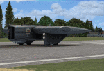
Sky Pirates Medium Vanship by Mellin - Version 1.0.0
If you are interested with updates check: https://onedrive.live.com/redir?resid=D237841111C490A2!2055&authkey=!ALJGm8kyIEpPWOc&ithint=folder%2ctxt
Vanships come from "Last Exile" and "Last Exile: Silver Wing Fam" animes. Sky Pirate Medium Vanships are a type of vanship which appear in Last Exile - Fam, The Silver Wing. In addition to Vespas, the Sky Pirates use a special type of vanship with an unusually broad and flat body. They resemble a rectangular wing with the cockpit in the center and two engines, one on each side. These ships are sometimes armed with harpoons to be used in capturing larger vessels. Because of their broad wings, they are capable of carrying up to six harpoons while Vespas can carry only two. It should be noted that each of these six however are about the size of a vespa. Their true amount of payload can be seen during the attack on Boraeas fortress, where Fam and Giselle's Vespa only mounts two rockets, each of these ships is seen carrying entire racks of them, with one being seen with 12 rocket pods slung under each wing, in formation with Fam's group shortly before they come under heavy fire. Those Vanships have 2 fuel tanks inside their wings and a big cargo bay in a middle of there body.They also have a observer's spot under main body in the front. It is equipped with periscope/binoculars.
More information about Vanships can be found on Last Exile wiki: http://lastexile.wikia.com/wiki/Vanship
| Filename: | Sky_Pirates_Medium_Vanship.zip |
| License: | Freeware |
| Added: | 17th February 2016, 22:01:56 |
| Downloads: | 142 |
| Author: | Piotr Mellin Malicki |
| Size: | 55.41 MB |
| Category: Flight Simulator X - Scenery | |
| Victoria, Canada including US Southern Gulf Islands and San Juan Islands - Part 1 of 2 |
|
Images related to this file:
File Description:
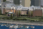
FSX-only version of Victoria, Canada area scenery including the Southern Gulf Islands and the San Juan Islands of the US. Includes automated installer and configurator by Scot Fraser.
Features:
-accurate shorelines, lakes and streams;
-landclass;
-FSX multi-LOD mesh with 10m maximum resolution;
-complete road network with moving traffic;
-railroads;
-utility corridors;
-marinas and ferry terminals;
-many static boats, including a custom model of the Canada Coast Guard ship Sir Wilfred Laurier;
-detailed models of major buildings and the Ogden Point Terminal;
-many bridges;
-nearly 300 marine lights; and corrected antennae locations.
Facilities include Don Grovestine's famous CYYJ (Victoria International Airport); 12 other Canadian land-based airports: Butler Field, Duncan (CAM3), Gaines, Hastings, Hudson Island, James Island, Thomas, Village Bay, Raven Field (CML2), Saltspring, Sidney Island, Whiskey Point; 20 US airports Blakely (38WA), Burden (61WA), Center Island (79WA), Clam Harbor (WA35), Crane Island, Decatur Shores (WN07), Decatur-Jones (WA18), Waldronaire (90WA), Orcas Island (KORS), Friday Harbour (KFHR), Lopez Island (S31), Pile Point, Roche Harbor (WA09), Shaw Island, Stuart Island Airpark (7WA5), Stuart Island West (2WA3), Wilding (6WA5), Windsock (4WA4); 12 floatplane facilities: Bedwell (CAB3), Fisherman's Bay (WA81), Friday Harbor (W33), Ganges (CAX6), Maple Bay, Mayne (CAW7), Port Washington (CAP8), Roche Harbor (W39), Rosario (W49), Shawnigan Lake (CAV8), Victoria Harbour (CYWH), Victoria International (CAP5) and Westsound, Orcas (WA83) - many with AI traffic; 9 heliports: Ganges (CAL7), Mayne (CBF5), Camel Point (CBF7), Jubilee (CBK8), Victoria General (CBW7) Madrona Bay (CBW9), Shoal Point (CBZ7), Mount Belcher (CMBH).
AI models include the DHC-2 floatplane in local liveries, a cruise ship model (by Mitsuya Hamaguchi) and two repaints, pilot boat, and small boats (by Larry Silsbee).
Ultimate Terrain X compatible (not required). Users of Vancouver+ for FSX will also get additional cruise ship traffic and additional floatplane and helicopter traffic. Full documentation. By Don Grovestine, Jon Patch and Holger Sandmann. Many other contributors: see documentation. Part 1 of 2 - you also need file vicenh7b.zip
| Filename: | Victoria_Canada_including_US_Southern_Gulf_Islands.zip |
| License: | Check within download |
| Added: | 29th January 2010, 21:23:17 |
| Downloads: | 23,155 |
| Author: | Don Grovestine, Jon Patch and Holger Sandmann |
| Size: | 56.8 MB |
| Category: Flight Simulator 2004 - Scenery | |
| The Victoria Falls of the Zambezi River, Zambia/Zimbabwe |
|
File Description:
One of the main landmarks of Africa, the spectacular Victoria Falls of the Zambezi River are missing in out-of-the-box FS. With a local SRTM LOD9 mesh as a base (included) and the help of satellite imagery, maps, Ground2K4, and GMax, we did our best to model a realistic representation of the falls, the river, and the gorge, complete with custom waterfall and spray effects. The portion of the Zambezi covered in this project extends from E25 to E26.5 (more than 100km), with the falls at its center. Also included is a replacement landclass file for an area of about 20km on either side of the Zambezi River and an optional AI boat (by Lynn and Bill Lyons) cruising on the Zambezi above the falls. Tested with FS2004 only but most scenery enhancements (not the AI boat) should work just as well in FS2002.
| Filename: | The_Victoria_Falls_of_the_Zambezi_River_ZambiaZimb.zip |
| License: | Freeware, limited distribution |
| Added: | 8th May 2004, 02:45:30 |
| Downloads: | 19,138 |
| Author: | Holger Sandmann and Johan van Wyk, Aeroworx |
| Size: | 3.5 MB |
| Category: Flight Simulator X - Scenery | |
| Victoria, Canada including US Southern Gulf Islands and San Juan Islands - Part 2 of 2 |
|
Images related to this file:
File Description:

FSX-only version of Victoria, Canada area scenery including the Southern Gulf Islands and the San Juan Islands of the US. Includes automated installer and configurator by Scot Fraser.
Features:
-accurate shorelines, lakes and streams;
-landclass;
-FSX multi-LOD mesh with 10m maximum resolution;
-complete road network with moving traffic;
-railroads;
-utility corridors;
-marinas and ferry terminals;
-many static boats, including a custom model of the Canada Coast Guard ship Sir Wilfred Laurier;
-detailed models of major buildings and the Ogden Point Terminal;
-many bridges;
-nearly 300 marine lights; and corrected antennae locations.
Facilities include Don Grovestine's famous CYYJ (Victoria International Airport); 12 other Canadian land-based airports: Butler Field, Duncan (CAM3), Gaines, Hastings, Hudson Island, James Island, Thomas, Village Bay, Raven Field (CML2), Saltspring, Sidney Island, Whiskey Point; 20 US airports Blakely (38WA), Burden (61WA), Center Island (79WA), Clam Harbor (WA35), Crane Island, Decatur Shores (WN07), Decatur-Jones (WA18), Waldronaire (90WA), Orcas Island (KORS), Friday Harbour (KFHR), Lopez Island (S31), Pile Point, Roche Harbor (WA09), Shaw Island, Stuart Island Airpark (7WA5), Stuart Island West (2WA3), Wilding (6WA5), Windsock (4WA4); 12 floatplane facilities: Bedwell (CAB3), Fisherman's Bay (WA81), Friday Harbor (W33), Ganges (CAX6), Maple Bay, Mayne (CAW7), Port Washington (CAP8), Roche Harbor (W39), Rosario (W49), Shawnigan Lake (CAV8), Victoria Harbour (CYWH), Victoria International (CAP5) and Westsound, Orcas (WA83) - many with AI traffic; 9 heliports: Ganges (CAL7), Mayne (CBF5), Camel Point (CBF7), Jubilee (CBK8), Victoria General (CBW7) Madrona Bay (CBW9), Shoal Point (CBZ7), Mount Belcher (CMBH).
AI models include the DHC-2 floatplane in local liveries, a cruise ship model (by Mitsuya Hamaguchi) and two repaints, pilot boat, and small boats (by Larry Silsbee).
Ultimate Terrain X compatible (not required). Users of Vancouver+ for FSX will also get additional cruise ship traffic and additional floatplane and helicopter traffic. Full documentation. By Don Grovestine, Jon Patch and Holger Sandmann. Many other contributors: see documentation. Part 2 of 2 - you also need file vicenh7a.zip
| Filename: | Victoria_Canada_including_US_Southern_Gulf_Islands.zip |
| License: | Check within download |
| Added: | 29th January 2010, 21:21:49 |
| Downloads: | 23,159 |
| Author: | Don Grovestine, Jon Patch and Holger Sandmann |
| Size: | 59.08 MB |
| Category: Flight Simulator 2004 - Aircraft Repaints, Textures and Modifications | |
| P-51D 531st FS Iwo Jima '313 |
|
File Description:
P-51D 44-63934 was assigned to 1Lt John F. Galbraith. He joined the 531st FS/21st FG when he was flying p-39's in Hawaii, and converted to the P-38 and P-51. He was credited with killing nine Japanese soldiers on Iwo Jima during the 26 March 1945 banzai raid, before being wouded. He soon returned to the squadron and began flying VLR (very long range) missions. He most vividly recalls strafing Japanese ships that were closing in on a American submarine. He said he flew '313' because everybody else in the 531st FS was too superstitious to go near it. Repaint for the Shockwave WWII Fighters Mustang by Jan Kees Blom, based on paintkit by John Terrell.
| Filename: | P51D_531st_FS_Iwo_Jima_313.zip |
| License: | Freeware, limited distribution |
| Added: | 30th October 2007, 14:39:27 |
| Downloads: | 230 |
| Author: | Jan Kees Blom |
| Size: | 9.6 MB |
© 2001-2026 AVSIM Online
All Rights Reserved
Privacy Policy |