
Where Flight Simulation Enthusiasts Gather from Around the World!
AVSIM Library - Search Results

| Category: Flight Simulator 2004 - Scenery | |
| Himalayas LOD9 Base Mesh, Volume 2 - Southcentral Ranges |

|
Images related to this file:
File Description:
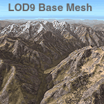
Detailed terrain mesh of the Southcentral Himalayan Ranges, N26-32 E82-90. The files in this package are based on Shuttle Radar (SRTM) Version 2 data but with many of the void areas, especially the most significant sections, filled with elevation data generated from topographic maps by Jonathan de Ferranti. While Jonathan's work is unrelated to flight simulation he kindly gave me permission to compile his data for use in FS. The result is a wonderful improvement in detail and accuracy over any existing mesh file, freeware or commercial, based on SRTM or DTED data alone.
Due to the large area of the Himalayas I've compiled the source data as two separate series: the "Himalayan Peaks" series covers prominent mountains and ranges in higher detail and locally overrides any existing LOD9 terrain mesh. In addition, a LOD9 "base mesh" series, with LOD8 and LOD7 "buffer" mesh files, covering the entire Himalayas, is meant for those who do not yet have an add-on terrain mesh of these beautiful mountains.
| Filename: | Himalayas_LOD9_Base_Mesh_Volume_2__Southcentral_Ra.zip |
| License: | Freeware, limited distribution |
| Added: | 29th May 2010, 09:05:56 |
| Downloads: | 9,446 |
| Author: | Holger Sandmann, Jonathan de Ferranti |
| Size: | 90.25 MB |
| Category: Flight Simulator 2004 - Scenery | |
| Himalayas LOD9 Base Mesh, Volume 4 - Kashmir and Jammu |
|
File Description:
Detailed terrain mesh of the Kashmir and Jammu Ranges, N30-39 E76-78. The files in this package are based on Shuttle Radar (SRTM) Version 2 data but with many of the void areas, especially the most significant sections, filled with elevation data generated from topographic maps by Jonathan de Ferranti. While Jonathan's work is unrelated to flight simulation he kindly gave me permission to compile his data for use in FS. The result is a wonderful improvement in detail and accuracy over any existing mesh file, freeware or commercial, based on SRTM or DTED data alone.
Due to the large area of the Himalayas I've compiled the source data as two separate series: the "Himalayan Peaks" series covers prominent mountains and ranges in higher detail and locally overrides any existing LOD9 terrain mesh. In addition, the LOD9 "base mesh" series, with LOD8 and LOD7 "buffer" mesh files, covering the entire Himalayas, is meant for those who do not yet have an add-on terrain mesh of these beautiful mountains.
| Filename: | Himalayas_LOD9_Base_Mesh_Volume_4__Kashmir_and_Jam.zip |
| License: | Freeware, limited distribution |
| Added: | 22nd February 2006, 20:32:50 |
| Downloads: | 7,502 |
| Author: | Holger Sandmann, Jonathan de Ferranti |
| Size: | 29.24 MB |
| Category: Flight Simulator 2004 - Scenery | |
| Himalayas LOD9 Base Mesh, Volume 3 - Southwestern Ranges |
|
Images related to this file:
File Description:

Detailed terrain mesh of the Southwestern Himalayan Ranges, N28-37 E78-82. The files in this package are based on Shuttle Radar (SRTM) Version 2 data but with many of the void areas, especially the most significant sections, filled with elevation data generated from topographic maps by Jonathan de Ferranti. While Jonathan's work is unrelated to flight simulation he kindly gave me permission to compile his data for use in FS. The result is a wonderful improvement in detail and accuracy over any existing mesh file, freeware or commercial, based on SRTM or DTED data alone.
Due to the large area of the Himalayas I've compiled the source data as two separate series: the "Himalayan Peaks" series covers prominent mountains and ranges in higher detail and locally overrides any existing LOD9 terrain mesh. In addition, the LOD9 "base mesh" series, with LOD8 and LOD7 "buffer" mesh files, covering the entire Himalayas, is meant for those who do not yet have an add-on terrain mesh of these beautiful mountains.
| Filename: | Himalayas_LOD9_Base_Mesh_Volume_3__Southwestern_Ra.zip |
| License: | Freeware, limited distribution |
| Added: | 30th May 2010, 10:00:26 |
| Downloads: | 155,807 |
| Author: | Holger Sandmann, Jonathan de Ferranti |
| Size: | 62.16 MB |
| Category: Flight Simulator 2004 - Scenery | |
| Himalayas LOD9 Base Mesh, Volume 5 - Hindu Kush and Pamir |
|
Images related to this file:
File Description:

Detailed terrain mesh of the Hindu Kush and Pamir Ranges, N32-40 E70-76. The files in this package are based on Shuttle Radar (SRTM) Version 2 data but with many of the void areas, especially the most significant sections, filled with elevation data generated from topographic maps by Jonathan de Ferranti. While Jonathan's work is unrelated to flight simulation he kindly gave me permission to compile his data for use in FS. The result is a wonderful improvement in detail and accuracy over any existing mesh file, freeware or commercial, based on SRTM or DTED data alone.
Due to the large area of the Himalayas I've compiled the source data as two separate series: the "Himalayan Peaks" series covers prominent mountains and ranges in higher detail and locally overrides any existing LOD9 terrain mesh. In addition, the LOD9 "base mesh" series, with LOD8 and LOD7 "buffer" mesh files, covering the entire Himalayas, is meant for those who do not yet have an add-on terrain mesh of these beautiful mountains.
| Filename: | Himalayas_LOD9_Base_Mesh_Volume_5__Hindu_Kush_and_.zip |
| License: | Freeware, limited distribution |
| Added: | 29th May 2010, 08:57:29 |
| Downloads: | 7,602 |
| Author: | Holger Sandmann, Jonathan de Ferranti |
| Size: | 85.72 MB |
| Category: Flight Simulator 2004 - Scenery | |
| Canadian Mountain Parks Pack |
|
File Description:
FS2004 Scenery - This file creates 12 new airports in six of Canada's National Parks (Banff, Jasper, Kootenay, Yoho, Glacier and Mt Revelstoke). Required is Holger Sandmann's excellent BC mesh, which is the reason for this file in the first place, and Lago's FSE demo file. Pack designed for low level visual 30 mile scenic flights with some tourist attraction additions (Takakkaw Falls, Emerald Lake, Lake Louise, Morainne Lake, Spiral Tunnel etc). The strips are ficticious, but the names and places are real. There is parking for you to add your own AI traffic as well. There are also improvements to other area strips (mainly lights and taxiways). Six flights included.
| Filename: | Canadian_Mountain_Parks_Pack.zip |
| License: | Freeware |
| Added: | 11th April 2004, 23:15:31 |
| Downloads: | 5,262 |
| Author: | Peter Vibe |
| Size: | 1.68 MB |
| Category: Flight Simulator 2004 - Flight Plans | |
| BOAC - Southampton to Johannesburg by Short Solent - 1949 |
|
File Description:
On the 4th. May 1949 BOAC introduced Short Solent flying boats to Southampton-Johannesburg service.
These new 'boats replaced the Hythe-class aircraft used since the War but they were destined to only serve for about a year before flying boats were withdrawn from the South African service completely. The route, which took four-and-a-half days to complete, was Southampton - Augusta (Sicily) - Cairo - Luxor - Khartoum - Port Bell (on the northern extremity of Lake Victoria, in Uganda) - Victoria Falls and then Vaaldam (or "Vaal Dam"), a large lake approx. 40 miles south of Johannesburg. Readme included. (One additional file is required - vicfalls.zip, by Holger Sandmann - available right here on Avsim.com.)
| Filename: | BOAC__Southampton_to_Johannesburg_by_Short_Solent_.zip |
| License: | Freeware |
| Added: | 1st October 2006, 19:03:35 |
| Downloads: | 594 |
| Author: | Bruce Kennewell |
| Size: | 253.3 KB |
| Category: Flight Simulator X - Miscellaneous Files | |
| Fleet Traffic US Navy Promo Documentation |
|
File Description:
These are promo materials associated with an AI Navy ship traffic package named FLEET TRAFFIC: US Navy by Haze Gray Studios. In response to several requests, we shared most of the documentation, so that prospective buyers could have a better idea of what is included in the FLEET TRAFFIC: US Navy package, and what is not.
Here you will find not only just a list of ships and hull numbers included, but the timetables for the traffic and the AI traffic routes in KMZ format which can be viewed in Google Earth.
| Filename: | Fleet_Traffic_US_Navy_Promo_Documentation.zip |
| License: | Freeware |
| Added: | 30th December 2017, 19:20:46 |
| Downloads: | 230 |
| Author: | Mark Sewell |
| Size: | 4.1 MB |
| Category: Flight Simulator 2004 - Miscellaneous Files | |
| Submarine Operations WW2 Pacific Theater |
|
File Description:
Take a ride through history with the greatest generation..Command an U.S.
submarine during world war II on several mission scenarios, based on several WW2 movies for action. All of the subs,ships,planes were created by myself
and transfered into the Lago FSE program. You must own a copy of the Lago
FSE version 1.10 program plus download the Lago Exchange module to activate my files into it. More info on that
in my zip. Special thanks to Ian Thatcher for the Sub cfg file to compile from FSSHIPYARDS.com
| Filename: | Submarine_Operations_WW2_Pacific_Theater.zip |
| License: | Freeware |
| Added: | 14th July 2005, 03:48:39 |
| Downloads: | 821 |
| Author: | Ron Jeffers |
| Size: | 10.86 MB |
| Category: Fly! II - TerraScene | |
| Alabama's Battleship Cove Terrascene Project |
|
File Description:
This is where Florida ends, where Alabama touches the Gulf of Mexico and the beginning of Mississippi. Lots of bayous, sloughs, islands and rivers. Another Fisherman's paradise and home to Pascagoula shipyard. The first warship to enter Tokyo Bay after the Atom Bomb was dropped is moored permanently here. The USS Alabama (BB-60) along with the USS Drum (SS-228). Both ships saw extensive service in WW2 and were the first warships I'd ever visited as a boy. This global tile completes the Florida Terrascene Project. Fair Winds and Following Seas...
| Filename: | Alabamas_Battleship_Cove_Terrascene_Project.zip |
| License: | Freeware |
| Added: | 9th February 2004, 04:44:39 |
| Downloads: | 312 |
| Author: | James Burns |
| Size: | 2.64 MB |
| Category: Flight Simulator 2004 - Scenery | |
| California Lighthouse and San Pedro harbor for Ultimate Terrain |
|
File Description:
This is a revision of my prior California Lighthouse scenery, adjusted to work with Ultimate Terrain. A licensed install of Ultimate Terrain USA is required to display properly.
Aside from placing 22 lighthouses on the coast of California, there are also many changes made to San Pedro Bay (Los Angeles harbor and Long Beach harbor). I moved misplaced objects (shipping cranes, container ships, etc) to where they belong and added marinas and custom bridges that follow the roads. I also added the breakwaters at the harbor.
The major bridges and offshore rocks are landable.
| Filename: | California_Lighthouse_and_San_Pedro_harbor_for_Ult.zip |
| License: | Freeware |
| Added: | 17th January 2006, 03:49:19 |
| Downloads: | 1,886 |
| Author: | Larry Silsbee |
| Size: | 3.39 MB |
© 2001-2026 AVSIM Online
All Rights Reserved
Privacy Policy |