
Where Flight Simulation Enthusiasts Gather from Around the World!
AVSIM Library - Search Results

| Category: Flight Simulator 2004 - Scenery | |
| Colorado Springs South (KCOS), Colorado, Photo-Scenery |

|
Images related to this file:
File Description:
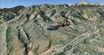
Colorado Springs South (KCOS), Colorado, Photo-Scenery (FS9 & FSX)
This region covers the area of Colorado Springs. Just west of the city you can fly around Pikes Peak. At 14.115ft it is the easternmost of Colorado's 54 fourteeners. Northwest of the city lies the Garden Of Gods with its many vertical rock formations. They are made of sedimentary beds red and white sandstones, conclomerates and limestone that were deposited horizontally but have been tilted vertically and faulted by the immense mountain building forces caused by the uplift of the Pikes Peak massiv. Deep within Chayenne Mountain is the North American Aerospace Defense Command's (NORAD) main technical facility which collects and evaluates data from a worldwide system of satellites, radars and other sensors.
High resolution versions of this scenery for FS9 and FSX (much sharper, but larger and multiple downloads) are available at www.blueskyscenery.com/GNB_South3East.html . The screenies are taken from the high-res versions, so expect this version to be slightly more blurry. YourDonation@Work: Dedicated to Veit and Hector.
| Filename: | gnb_south3east_2010_lr.zip |
| License: | Freeware, limited distribution |
| Added: | 5th February 2010, 16:30:42 |
| Downloads: | 1,970 |
| Author: | Gottfried Razek, blueskyscenery.com |
| Size: | 95.63 MB |
| Category: Flight Simulator 2004 - Scenery | |
| Park County, Colorado, Photo-Scenery (FS9 & FSX) |
|
Images related to this file:
File Description:
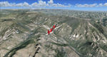
Covers the gap between my Leadville and Colorado Springs North sceneries and provides you with continuous coverage for longer cross country flights. High resolution versions of this scenery for FS9 and FSX (much sharper, but larger and multiple downloads) are available at www.blueskyscenery.com/GNB_South2.html . The screenies are taken from the high-res versions, so expect this version to be slightly more blurry. YourDonation@Work: Dedicated to Arthur and Pierre-Alain.
| Filename: | gnb_south2_2010_lr.zip |
| License: | Freeware, limited distribution |
| Added: | 3rd February 2010, 22:19:58 |
| Downloads: | 1,410 |
| Author: | Gottfried Razek - blueskyscenery.com |
| Size: | 89.49 MB |
| Category: Flight Simulator 2004 - Scenery | |
| Fremont County, Colorado, Photo-Scenery |
|
Images related to this file:
File Description:
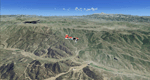
Fremont County, Colorado, Photo-Scenery (FS9 & FSX)
Covers the gap between my Buena Vista and Colorado Springs South sceneries and provides you with continuous coverage for longer cross country flights. High resolution versions of this scenery for FS9 and FSX (much sharper, but larger and multiple downloads) are available at www.blueskyscenery.com/GNB_South3.html . The screenies are taken from the high-res versions, so expect this version to be slightly more blurry. YourDonation@Work: Dedicated to Senges and Dennis.
| Filename: | gnb_south3_2010_lr.zip |
| License: | Freeware, limited distribution |
| Added: | 13th February 2010, 14:33:42 |
| Downloads: | 1,324 |
| Author: | Gottfried Razek, blueskyscenery.com |
| Size: | 92.11 MB |
| Category: Flight Simulator 2004 - Scenery | |
| Gunnison (KGUC), Colorado, Photo-Scenery |
|
Images related to this file:
File Description:
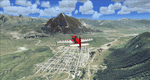
Gunnison (KGUC), Colorado, Photo-Scenery (FS9 & FSX)
Extends my Aspen scenery to the south from Crested Butte to Gunnison (KGUC) and beyond. Contains the West Elk Wilderness Area and the Curecanti Nat'l. Rec. Area around Morrow Point Reservoir. This scenery brings you another 3.500 sq km of beautiful Colorado in 4.7m/pix quality.
High resolution versions of this scenery for FS9 and FSX (much sharper, but larger and multiple downloads) are available at www.blueskyscenery.com/GNB_South3West2.html . The screenies are taken from the high-res versions, so expect this version to be slightly more blurry. YourDonation@Work: Dedicated to Alain, Jacques and Lefevre.
| Filename: | gnb_south3west2_2010.zip |
| License: | Freeware, limited distribution |
| Added: | 6th February 2010, 11:08:59 |
| Downloads: | 1,717 |
| Author: | Gottfried Razek, blueskyscenery.com |
| Size: | 90.83 MB |
| Category: Flight Simulator 2004 - Scenery | |
| Arches National Park, Moab (KCNY), Utah, Photo-Scenery (FSX too) |
|
File Description:
This scenery covers another beautiful National Park: Arches National Park near Moab in Utah. It contains the park itself, Moab, the La Sal Moutains and the northern part of Canyonlands National Park, which will be covered in an upcoming package. The total area is 3.500 sq km and comes in 4.7m/pix quality. To explore the scenery depart from Canyonlands Field Airport (KCNY) and head south. YourDonation@Work: Dedicated to Hector, William and Jerald. Thanks!
| Filename: | cny2009_lr.zip |
| License: | Freeware, limited distribution |
| Added: | 5th January 2009, 19:31:11 |
| Downloads: | 3,695 |
| Author: | Gottfried Razek - www.blueskyscenery.com |
| Size: | 94.68 MB |
| Category: Flight Simulator 2004 - Scenery | |
| Sierra Nevada, California, Part 6: Sequoia National Park II (West) |
|
File Description:
This is the sixt part of BlueSky's Sierra Nevada project and the second part of Seqouia National Park. Connects seamlessly and extends the first part (Sequoia I) to the west. Completes the High Sierra packages and brings the total to 21.000 sq km covering three National Parks (Sequoia, Kings Canyon and Yosemite). Works equally well in FS2004 and FSX. YourDonation@Work: Dedicated to the donators Markus, Michael and Bernd. Thanks!
| Filename: | seq_west2008_lr.zip |
| License: | Freeware, limited distribution |
| Added: | 3rd March 2008, 10:48:19 |
| Downloads: | 3,946 |
| Author: | Gottfried Razek (www.blueskyscenery.com) |
| Size: | 90.92 MB |
| Category: Flight Simulator 2004 - Scenery | |
| Canyonlands National Park, The Maze-South, Utah, Photo-Scenery (FSX too) |
|
Images related to this file:
File Description:
This is a re-upload of a package that was corrupted during the crash of the AVSIM library. This is the fourth package of the Arches/Canyonlands area. It covers the area southwest and including the confluence of the Colorado and Green Rivers. From there you can fly down Cataract Canyon which is famed for its premium whitewater rafting oportunities. Or explore the Maze (the area west of the Green and north of the Colorado River) with it's labyrinth of canyons and colorful sandstone formations. The scenery extends west to Hite (UT03) on Lake Powell. Brings the total Southern Utah coverage to 14.000 sq km in 4.7m/pix quality. YourDonation@Work: Dedicated to Patrick, Hideyuki and Art. Thanks!
| Filename: | cny_southwest2009_lr.zip |
| License: | Freeware, limited distribution |
| Added: | 31st December 2009, 22:33:46 |
| Downloads: | 2,068 |
| Author: | Gottfried Razek - blueskyscenery.com |
| Size: | 95.67 MB |
| Category: Flight Simulator 2004 - Scenery | |
| Tucson, Arizona, High-Resolution Scenery - Part 1: Tucson Intl. Airport (KTUS) |
|
File Description:
This is the first part of high resolution ground scenery for Tucson AZ, containing Tucson Intl. airport (KTUS) and 90 sq km around it. The resolution of the airport area itself is 0.3m/pix! The area around is in 1m/pix resolution. Realistic real-world runway textures are provided as well. This scenery is best, when combined with my standard resolution Tucson scenery (TUS2008_LR.zip), which covers a much larger area and matches perfectly in color and everything. YourDonation@Work: Dedicated to Robert, George and Jeff. Thanks!
| Filename: | tus2008_hr.zip |
| License: | Freeware, limited distribution |
| Added: | 10th September 2008, 23:58:16 |
| Downloads: | 4,243 |
| Author: | Gottfried Razek - www.blueskyscenery.com |
| Size: | 97.18 MB |
| Category: Flight Simulator 2004 - Scenery | |
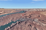
| Lake Powell - Bullfrog Basin (U07), Utah, Photo-Scenery (FS9 & FSX) |
|
Images related to this file:
File Description:
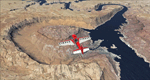
This scenery covers the area from the southern end of the Waterpocket Fold down to the Bullfrog Basin and the eastern end of the Kiaparowits Plateau. It extends my Canyonlands sceneries to the southwest and brings you another 3.500 sq km in 4.7m/pix quality. To explore the scenery depart from Bullfrog Basin Airport (U07) and west. High resolution versions of this scenery for FS9 and FSX (much sharper, but larger and multiple downloads)
are available at www.blueskyscenery.com/CNY_South2West2.html . The screenies are taken from the high-res versions, so expect this version to be slightly more blurry. YourDonation@Work: Dedicated to Jean-Marc, Jim and Cay.
| Filename: | cny_south2west2_2010_lr.zip |
| License: | Freeware, limited distribution |
| Added: | 18th January 2010, 19:27:52 |
| Downloads: | 1,587 |
| Author: | Gottfried Razek - blueskyscenery.com |
| Size: | 92.83 MB |
| Category: Flight Simulator 2004 - Scenery | |
| Denver (KDEN), Colorado, Photo-Scenery |
|
Images related to this file:
File Description:
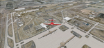
Denver (KDEN), Colorado, Photo-Scenery for FS9 & FSX.
This package covers Denver, the capital of Colorado which is also nicknamed Mile-High City because its elevation is one mile (5.280 ft). The sixth RW (16R/34L) of Denver Int'l. Airport (KDEN) is the longest commercial RW in the US with a length of 16.000ft. This allows fully loaded B747's to take off in Denvers mile-high altitude during hot summer days, when density altitudes can approach 9.000(!) ft.
KDEN is a major hub for United Airlines and the headquarters for Frontier Airlines. The airports distinctive white tent-like fabric roof is designed to be reminiscent of the snow-covered peaks of the Rocky Mountains which you can see on approach or departure.
Other important airports covered by this region are Centennial Airport (KAPA), Buckley AFB (KBKF) and Rocky Mountain Metropolitan Airport (KBJC). Extends my Mt.Evans/Georgetown package to the east and provides another 3.500 sq km in 4.7m/pix quality.
High resolution versions for FS9 and FSX (much sharper, but larger and multiple downloads) are available at www.blueskyscenery.com/GNB_SouthEast.html
. The screenies are taken from the high-res versions, so expect this version to be slightly more blurry. YourDonation@Work: Dedicated to Mark and Charles. Thanks!
| Filename: | gnb_southeast2009_lr.zip |
| License: | Freeware, limited distribution |
| Added: | 31st October 2009, 11:24:39 |
| Downloads: | 7,193 |
| Author: | Gottfried Razek, blueskyscenery.com |
| Size: | 95.21 MB |
© 2001-2025 AVSIM Online
All Rights Reserved