
Where Flight Simulation Enthusiasts Gather from Around the World!
AVSIM Library - Search Results

| Category: Flight Simulator 2004 - Scenery | |
| Buena Vista, Central Colorado Reg. (KAEJ form. 7V1), Colorado, Photo-Scenery (FS9 & FSX) |

|
Images related to this file:
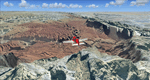
File Description:
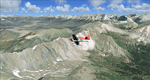
This region covers the area around Buena Vista and Central Colorado Reg. (KAEJ form. 7V1). It extends
my Leadville scenery to the south and brings you another 3.500 sq km of beautiful Colorado in 4.7m/pix quality. High resolution versions of this scenery for FS9 and FSX (much sharper, but larger and multiple downloads) are available at www.blueskyscenery.com/GNB_South3West.html . The screenies are taken from the high-res versions, so expect this version to be slightly more blurry. YourDonation@Work: Dedicated to Matias and Markus.
| Filename: | gnb_south3west_2010.zip |
| License: | Freeware, limited distribution |
| Added: | 7th February 2010, 11:31:14 |
| Downloads: | 1,566 |
| Author: | Gottfried Razek - blueskyscenery.com |
| Size: | 93.89 MB |
| Category: Flight Simulator 2004 - Scenery | |
| Eagle County (KEGE), Glenwood Springs (KGWS), Colorado, Photo-Scenery (FS9 & FSX) |
|
Images related to this file:
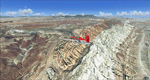
File Description:
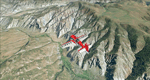
To explore this region depart from Eagle County Regional Airport (KEGE) which is a popular regional airport used in winter to transport skiers to nearby Vail. Northwest of the airport you can see the pit gypsum mine of American Gypsum which produces a variety of wallboard products. When you fly to the west and along the Eagle River, you soon pass its confluence with the Colorado River. Further west you can fly along Glennwood Canyon and finally reach Glennwood Springs where the Colorado meets the Roaring Fork River. Here you can turn south and fly direct Glenwood Springs Airport (KGWS) which lies south of the city. This scenery brings you another 3.500 sq km of beautiful Colorado in 4.7m/pix quality.
High resolution versions of this scenery for FS9 and FSX (much sharper, but larger and multiple downloads) are available at www.blueskyscenery.com/GNB_SouthWest2.html . The screenies are taken from the high-res versions, so expect this version to be slightly more blurry. YourDonation@Work: Dedicated to Alain and James.
| Filename: | gnb_southwest2_2010_lr.zip |
| License: | Freeware, limited distribution |
| Added: | 30th January 2010, 17:01:49 |
| Downloads: | 2,684 |
| Author: | Gottfried Razek - blueskyscenery.com |
| Size: | 93.8 MB |
| Category: Flight Simulator 2004 - Scenery | |
| Boulder (KBDU) / Longmont / Loveland, Colorado, Photo-Scenery (FS9 & FSX) |
|
Images related to this file:
File Description:
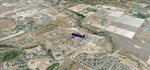
Boulder is situated where the Rocky Mountains meet the Great Plains. Just west of the city are imposing slabs of sedimentary stone tilted up on the foothills, known as Flatirons. Located at the base of the foothills is Boulder's main campus of the University of Colarado which is clearly visible from the sky. Longmont is home of the Denver ARTCC (Air Route Traffic Control Center) which controls all flights in the upper airspace of most of Colorado and parts of adjoining states. To explore the scenery depart from Boulder (KBDU) and head northeast. Extends my Rocky Mountain Park scenery to the east and my Denver scenery to the north. Provides another 3.500 sq km in 4.7m/pix quality. High resolution versions for FS9 and FSX (much sharper, but larger and multiple downloads) are available at www.blueskyscenery.com/GNB_East.html . The screenies are taken from the high-res versions, so expect this version to be slightly more blurry. YourDonation@Work: Dedicated to Senges and Eric.
| Filename: | gnb_east2009_lr.zip |
| License: | Freeware, limited distribution |
| Added: | 28th December 2009, 20:14:09 |
| Downloads: | 2,374 |
| Author: | Gottfried Razek - blueskyscenery.com |
| Size: | 94.26 MB |
| Category: Flight Simulator 2004 - Scenery | |
| Lake Powell, Navajo Mountain (04UT), Utah/Arizona, Photo-Scenery (FS9 & FSX) |
|
Images related to this file:
File Description:
This package contains the center of Lake Powell and the Navajo Nation around Navajo Mountain. It contains remote areas of stunning beauty. Wonderful sandstone formations in bright shades of red and pink. Contains landmarks like the Rainbow Bridge National Monument and the confluence of the Colorado and San Juan Rivers. Extends my Monument Valley scenery to the west and brings you another 3.500 sq km in 4.7m/pix quality. To explore the scenery depart from Navajo Mountain dirt strip (04UT). High resolution versions of this scenery for FS9 and FSX (much sharper, but larger and multiple downloads) are available at www.blueskyscenery.com/CNY_South3West2.html . The screenies are taken from the high-res versions, so expect this version to be slightly more blurry. YourDonation@Work: Joaquin, Donald and Scott.
| Filename: | cny_south3west2_2010_lr.zip |
| License: | Freeware, limited distribution |
| Added: | 23rd January 2010, 23:06:49 |
| Downloads: | 1,766 |
| Author: | Gottfried Razek - blueskyscenery.com |
| Size: | 91.43 MB |
| Category: Flight Simulator 2004 - Scenery | |
| Monument Valley, Kayenta (0V7), Utah/Arizona, Photo-Scenery |
|
Images related to this file:
File Description:
Monument Valley, Kayenta (0V7), Utah/Arizona, Photo-Scenery (FS9 & FSX)
This scenery covers the area from south of the San Juan River down to wonderful Monument Valley and Kayenta, AZ.
It extends my Lake Powell sceneries to the south and brings you another
3.500 sq km in 4.7m/pix quality. To explore the scenery depart from Kayenta (0V7) and head north.
High resolution versions of this scenery for FS9 and FSX (much sharper, but larger and multiple downloads) are available at www.blueskyscenery.com/CNY_South3West.html . The screenies are taken from the high-res versions, so expect this version to be slightly more blurry. YourDonation@Work: Dedicated to Thomas, Don and Eric.
| Filename: | cny_south3west_2010_lr.zip |
| License: | Freeware, limited distribution |
| Added: | 23rd January 2010, 10:45:32 |
| Downloads: | 2,259 |
| Author: | Gottfried Razek - blueskyscenery.com |
| Size: | 93.49 MB |
| Category: Flight Simulator 2004 - Scenery | |
| Las Vegas (KLAS), Nevada, Photo Scenery (FSX too) |
|
Images related to this file:
File Description:
This package contains photo-scenery for the greater area of Las Vegas, covering an area of 3.250 sq km and is dedicated to the donators Donald, John and David. The scenery reaches from the foothills of Mt. Charleston to Lake Mead (partly covered). The quality is in standard FS2004-resolution of 4.7m/pixel. It works equally well in FS2004 and FSX. Hi-Res overlays fill follow. For a complete list of available titles please visit us at www.blueskyscenery.com
| Filename: | las2007_lr.zip |
| License: | Freeware, limited distribution |
| Added: | 30th December 2009, 18:01:52 |
| Downloads: | 10,828 |
| Author: | Gottfried Razek - blueskyscenery.com |
| Size: | 80.59 MB |
| Category: Flight Simulator 2004 - Scenery | |
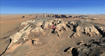
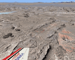
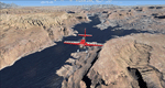
| Canyonlands National Park South, Monticello (U43), Utah, Photo-Scenery (FSX too) |
|
Images related to this file:
File Description:
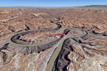
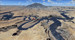
This scenery covers the southern part of Canyonlands National Park (Needles District) in Utah. The colorful layers of sand- and limestone that you can see today built over hundreds of millions years by advancing and retreating oceans as well as rivers that deposited huge amounts of sediment. About 15 million years ago these layers began to rise due to a colliding movement of plates in the earth's crust, forming what is today called the Colorado Plateau. As the land rose higher, erosion accelerated, resulting in countless canyons, mesas and buttes. The uplifting land caused the rivers to carve in even faster, resulting in the deep canyons of the Colorado and Green Rivers. The needles and fins in the Needles District have yet another story: First uplifts and later slides created a system of perpendicular cracks. Then he resulting crosshatched pattern of "joints" widened by erosion until only thin fins and needles of rock remained. The scenery extends my Arches National Park scenery to the south and brings you another 3.500 sq km in 4.7m/pix quality. To explore the scenery depart from Monticello (U43) and head north. YourDonation@Work: Dedicated to Nels, David and Michael. Thanks!
| Filename: | cny_south2009_lr.zip |
| License: | Freeware, limited distribution |
| Added: | 30th December 2009, 21:44:56 |
| Downloads: | 1,512 |
| Author: | Gottfried Razek - blueskyscenery.com |
| Size: | 95.76 MB |
| Category: Flight Simulator 2004 - Scenery | |
| Lake Powell East / Natural Bridges National Monument, Utah, Photo-Scenery |
|
Images related to this file:
File Description:
Lake Powell East / Natural Bridges National Monument, Utah, Photo-Scenery (FS9 & FSX)
This scenery covers the eastern part of Lake Powell from just south of Hite (UT03) and goes down south along White Canyon, Natural Bridges National Monument and the Grand Gulch Primitive Area all the way to the San Juan River. It extends my Canyonlands sceneries to the south and brings you another 3.500 sq km of wonderful southern Utah in 4.7m/pix quality. To explore the scenery depart from Cal Black Memorial Apt. (U96) and head east. High resolution versions of this scenery for FS9 and FSX (much sharper, but larger and multiple downloads) are available at www.blueskyscenery.com/CNY_South2West.html. The screenies are taken from the high-res versions, so expect this version to be slightly more blurry. YourDonation@Work: Dedicated to Guy, Ruben and EDB.
| Filename: | cny_south2west_2010_lr.zip |
| License: | Freeware, limited distribution |
| Added: | 4th January 2010, 19:19:43 |
| Downloads: | 1,857 |
| Author: | Gottfried Razek, blueskyscenery.com |
| Size: | 95.26 MB |
| Category: Flight Simulator 2004 - Scenery | |
| Capitol Reef National Park/North - Hanksville (KHVE), Utah, Photo-Scenery |
|
Images related to this file:
File Description:
Capitol Reef National Park/North - Hanksville (KHVE), Utah, Photo-Scenery (for FS9 & FSX)
This scenery covers the northern part of Capitol Reef National Park, Hanksville (KHVE), the Goblin Valley and extends north to I70 and the San Rafael Swell. It extends my Canyonlands sceneries to the west and brings you another 3.500 sq km in 4.7m/pix quality. To explore the scenery depart from Hanksville (KHVE) and head northwest. High resolution versions of this scenery for FS9 and FSX (much sharper, but larger and multiple downloads) are available at www.blueskyscenery.com/CNY_West2.html . The screenies are taken from the high-res versions, so expect this version to be slightly more blurry. YourDonation@Work: Dedicated to Andy and Robert.
| Filename: | cny_west2_2010_lr.zip |
| License: | Freeware, limited distribution |
| Added: | 13th January 2010, 19:32:33 |
| Downloads: | 1,678 |
| Author: | Gottfried Razek, blueskyscenery.com |
| Size: | 94.77 MB |
| Category: Flight Simulator 2004 - Scenery | |
| Capitol Reef National Park/South - Waterpocket Fold, Utah, Photo-Scenery |
|
Images related to this file:
File Description:
Capitol Reef National Park/South - Waterpocket Fold, Utah, Photo-Scenery (for FS9 & FSX)
This scenery covers the area from the southern part of Capitol Reef National Park down along the Waterpocket Fold and the Henry Mountains. It extends my Canyonlands sceneries to the west and brings you another 3.500 sq km in 4.7m/pix quality. To explore the scenery depart from Hanksville (KHVE) and head northwest. High resolution versions of this scenery for FS9 and FSX (much sharper, but larger and multiple downloads)
are available at www.blueskyscenery.com/CNY_SouthWest2.html . The screenies are taken from the high-res versions, so expect this version to be slightly more blurry. YourDonation@Work: Eric and Andy.
| Filename: | cny_southwest2_2010_lr.zip |
| License: | Freeware, limited distribution |
| Added: | 13th January 2010, 20:46:53 |
| Downloads: | 1,713 |
| Author: | Gottfried Razek - blueskyscenery.com |
| Size: | 95.92 MB |
© 2001-2025 AVSIM Online
All Rights Reserved