
Where Flight Simulation Enthusiasts Gather from Around the World!
AVSIM Library - Search Results

| Category: Flight Simulator 2004 - AFCAD Files | |
| Syamsudin Noor, Banjarmarsin, Indonesia (WAOO/BDJ) |

|
File Description:
Googlyafcad A&F Data file for WRBB Banjarmasin/Syamsudin Noor/Ulin in Kalimantan, Indonesia based on Google Earth satellite data. Unfortunately, Microsoft have provided very limited facilities at this important Indonesian domestic airport, served by over twenty-five flights a day by Adam Air, Airfast, Bali International, Batavia Air, Bouraq, Garuda, Indonesia Air Transport, Lion Airlines, Mandala Airlines, Merpati Nusentara
and Sriwijaya Air jets and smaller craft. This upgrade redresses the subject by supplementing the GA parking with gates so that you, and your "AI" traffic can land, taxi, park and take off realistically. Whilst this file improves the layout of the airport, it is not a full scenery upgrade and does not attempt correct building locations, landclass, taxiway signs or those stupid over-sized filling stations that Microsoft loves to put in annoying places. Regrettably the satellite data currently available is not of sufficient quality to do so.
| Filename: | Syamsudin_Noor_Banjarmarsin_Indonesia_WAOOBDJ.zip |
| License: | Freeware |
| Added: | 17th March 2007, 11:06:39 |
| Downloads: | 1,073 |
| Author: | John Hinson |
| Size: | 59.7 KB |
| Category: Flight Simulator 2004 - Scenery | |
| WION Ranai, Indonesia |
|
File Description:
Googly scenery for Ranai, a domestic airport located on Natuna Besar,
the main island of the 272 islands comprising the Natuna archipeligo in
Indonesia. The airport is served by daily flights of Riau Airlines using
Fokker 50 turboprop aircraft.
Flight Simulator 2004 has only provided a runway at this airport and this scenery
seeks to redress the situation so that you and your "AI" traffic can use the
airport.
The scenery does not purport to be ultra-accurate. Based on high quality
satellite imagery from Google Earth, the layout is proportionally correct but the
added airport features, such as buildings, are built from default Microsoft objects
and add-on libraries so will not look exactly like the real thing.
You are not obliged to download and install any additional scenery libraries,
but to enjoy this scenery in its entirety, you may wish to. It will work fine,
with or without.
| Filename: | WION_Ranai_Indonesia.zip |
| License: | Freeware |
| Added: | 11th October 2008, 13:12:55 |
| Downloads: | 1,242 |
| Author: | John Hinson |
| Size: | 60.07 KB |
| Category: Flight Simulator 2004 - Scenery | |
| HSMK Rumbek, Sudan |
|
File Description:
Googly scenery for HSMK Rumbek, a small airport serving the city of the same
name, capital of the Buhayrat (or Lakes) state in southern Sudan. The airport
is served daily by Beech 1900 aircraft operating for Delta Connection, a
Kenyan airline.
Flight Simulator 2004 has completely omitted this airport and this scenery
seeks to redress the situation so that you and your "AI" traffic can use the
airport.
The scenery does not purport to be ultra-accurate. Based on high quality
satellite imagery from Google Earth, the layout is proportionally correct but the
added airport features, such as buildings, are built from default Microsoft objects
and add-on libraries so will not look exactly like the real thing.
You are not obliged to download and install any additional scenery libraries,
but to enjoy this scenery in its entirety, you may wish to. It will work fine,
with or without.
| Filename: | HSMK_Rumbek_Sudan.zip |
| License: | Freeware |
| Added: | 19th April 2008, 20:33:09 |
| Downloads: | 754 |
| Author: | John Hinson |
| Size: | 78 KB |
| Category: Flight Simulator 2004 - AFCAD Files | |
| Manchester (EGCC/MAN) Ground Improvements (v1.0) |
|
File Description:
Includes: Ocean Sky ramp, ROMPA light aircraft park, TATON light aircraft park, Access to Western Maintenance, Re-designation of runways to current format (ILS etc. also changed to suit), Re-designation of taxiways, Frequency changes, Added some hold points (more in later version), Other general taxiway adjustments. The inspiration came from a recent VATSIM session from EGCC. I was flying my Tomahawk but had no scenery for TATON, ROMPA, or the Ocean Sky GA areas there. So I've used my real-world charts and Google Earth to add these three areas to the default AFCAD. Also note that the runways have been re-numbered to 23/05(L/R), and I have made the Western Maintenance area accessible. My other objective was to insert and change the taxiway designators, so many of these have been cleaned up and changed too. See Readme file for more details...enjoy!
| Filename: | Manchester_EGCCMAN_Ground_Improvements_v10.zip |
| License: | Freeware, limited distribution |
| Added: | 10th October 2008, 20:27:16 |
| Downloads: | 1,126 |
| Author: | David Hunter |
| Size: | 8.87 KB |
| Category: Flight Simulator 2004 - Scenery | |
| OP0C Bandari, Pakistan |
|
File Description:
Googly scenery for Bandari, a minor airport in Palistan served once weekly by
Metroliner turboprops of Royal Airlines. The airport has neither ICAO not IATA
status, but Microsoft have given it an unofficial ICAO code of OP0C.
Flight Simulator 2004 has only provided a runway at this airport and this scenery
seeks to redress the situation so that you and your "AI" traffic can use the
airport.
The scenery does not purport to be ultra-accurate. Based on high quality
satellite imagery from Google Earth, the layout is proportionally correct but the
added airport features, such as buildings, are built from default Microsoft objects
and add-on libraries so will not look exactly like the real thing.
You are not obliged to download and install any additional scenery libraries,
but to enjoy this scenery in its entirety, you may wish to. It will work fine,
with or without.
| Filename: | OP0C_Bandari_Pakistan.zip |
| License: | Freeware |
| Added: | 20th April 2008, 17:04:59 |
| Downloads: | 556 |
| Author: | John Hinson |
| Size: | 74.99 KB |
| Category: Flight Simulator 2004 - Scenery | |
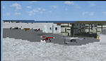
| Diavik Diamond Mine CDK2 |
|
Images related to this file:
File Description:
The Diavik Diamond Mine is located about 200 miles NE of Yellowknife in Canada's Northwest Territory. It a relatively new facility, having been begun production in 2003. The only means of access are by air or ice road. (If you are a James Bondian super villian plotting world domination, Diavik would be a great place for your secret underground headquarters.) This scenery is completely scratch built. In addition to the airstrip itself, I used Google Earth pics to create a photo ground texture of the adjoining facility. The buildings of the main processing complex are very simply modeled, as is the large open pit mine.
This scenery was designed for use with Ultimate Terrain and was not tested in the default scenery. (As far as I can tell, Ulimate Terrain does not affect the area around Diavik, so it should work OK.) It may or may not work in FSX.
| Filename: | Diavik_Diamond_Mine_CDK2.zip |
| License: | Freeware |
| Added: | 4th February 2011, 18:07:48 |
| Downloads: | 580 |
| Author: | Sidney Schwartz & Peter Ham |
| Size: | 994.9 KB |
| Category: Flight Simulator 2004 - Scenery | |
| OIBJ Jam/Tohid, Iran |
|
File Description:
Googly scenery for OIBJ Jam/Tohid - a small Iranian domestic airport for which
nothing more than a runway is provided in Flight Simulator 2004. These scenery
files add taxiways, aprons, buildings and other airport features so that you
and your "AI" traffic can land, taxi, park and take off in a realistic manner.
The airport is served about twice per week by Fokker jets of Iran Air.
The scenery does not purport to be ultra-accurate. Based on high-detail satellite
imagery from Google Earth, the layout is proportionally correct but the added
airport features, such as buildings, are built from default Microsoft objects
and add-on libraries so will not look like the real thing.
You are not obliged to download and install any additional scenery libraries,
but to enjoy this scenery in its entirety, you may wish to. It will work fine,
with or without.
| Filename: | OIBJ_JamTohid_Iran.zip |
| License: | Freeware |
| Added: | 8th July 2007, 21:19:39 |
| Downloads: | 1,020 |
| Author: | John Hinson |
| Size: | 80.11 KB |
| Category: Flight Simulator X - Scenery | |
| Provincetown Municipal Airport (KPVC) |
|
Images related to this file:
File Description:
This airport was made using Airport Facilitator X, and Instant Scenery 2. Provincetown Municipal Airport is a small airport located in Provincetown, Massachusetts. Cape Air is the only airline that flies there. I added a more accurate terminal, and an aircraft hangar. I put three fuel trucks on the ramp with a fuel station. I made the taxiways the correct length and width. I also put static aircraft on the ramp and added more gates. I made a parking lot with many cars in it. If you choose to start off from a DOCK gate, you will start off inside the aircraft hanger. Taxiing or starting off inside of the hanger will cause a crash unless you have crashes turned off. This is all based on Google Earth and Bing Maps. Please read the readme for instructions on how to install. This is for Flight Simulator X only.
| Filename: | Provincetown_Municipal_Airport_KPVC.zip |
| License: | Freeware |
| Added: | 21st January 2012, 20:08:09 |
| Downloads: | 606 |
| Author: | Tyler Lawrence |
| Size: | 6.86 MB |
| Category: Flight Simulator X - Scenery | |
| Beja Air Base, V3 |
|
File Description:
Beja Air Base, home of the squadrons 103 (with AlphaJets), 601 (with P-3) and 552 (with Alloette III). This scenery was developed in ADE9X (http://www.airportdesigneditor.co.uk/) from the original of FSX with the help of Google Earth.
In V1, all runways and aprons have the right size, were added default FSX buildings and vegetation and also a representation of the "Terminal Civil de Beja". Changes to V2 are the update of taxiways designations, dimensions of some taxiways, vegetation reviewed, the improved look of the "Terminal Civil de Beja", but the most important,
the Control Tower and its outbuildings and Fire Station created by my friend Mario Cera. In V3 the Control Tower and its outbuildings and Fire Station by Mario Cera have now more details and more textures. If you have V1 or V2 please replace them with new V3.
| Filename: | Beja_Air_Base_V3.zip |
| License: | Freeware |
| Added: | 16th February 2012, 13:55:56 |
| Downloads: | 3,523 |
| Author: | Jorge Ferreira, Mario Cera |
| Size: | 41.51 MB |
| Category: Flight Simulator X - Scenery | |
| Toulouse Blagnac (LFBO) v1 update |
|
Images related to this file:
File Description:
FSX Toulouse Blagnac Airport v1 modification update. This is an update of the addon scenery for FSX of the Toulouse Blagnac Airport. For using it, you need first to install /Toulouse Blagnac (LFBO) v1/ available in the Avsim library from myself (lfbo_scenery_v1.zip).
On this update, I have included the following (this is not an exhaustive list): Correction of the position of the ILS glide for the runway 32R/14L, improvement of the taxiways and connecting roads, correction of their position with Google earth, taxiways are well aligned with runways and surrounding buildings now, improvement of some existing buildings (i.e. old terminal), addition of customized buildings with day and night photo texture, improvement of the land class surrounding the installations, inclusion of water polygons, new assignment of gates for the Air France fleet (now located in new terminal F like in reality)
| Filename: | Toulouse_Blagnac_LFBO_v1_update.zip |
| License: | Freeware |
| Added: | 17th July 2012, 18:50:28 |
| Downloads: | 11,961 |
| Author: | Jose Mauriz |
| Size: | 29.73 MB |
© 2001-2026 AVSIM Online
All Rights Reserved
Privacy Policy |