
Where Flight Simulation Enthusiasts Gather from Around the World!
AVSIM Library - Search Results

| Category: Flight Simulator X - AFCAD Files | |
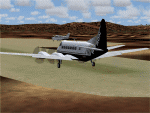
| S77 Magee Airstrip |

|
File Description:
This airstrip lies in the Coeur D'Alene national forest region right in the mountains, but FSX has it badly misplaced, right in the middle of a mountain, so you have the horrible looking cliffs on each side and front and back too, whereas the real airstrip is in a valley alongside and actually looks like a very nice spot to make a landing. I redid the airfield with ADE and also did the landclass for the valley to improve the overall appearance, using google earth as a reference.
I also added a small taxiway and parking, with hold short nodes, these are not part of the real world strip, but if you want AI planes to fly in and out of these strips then you need those features, otherwise the AI will just vanish.
| Filename: | S77_Magee_Airstrip.zip |
| License: | Freeware |
| Added: | 25th September 2010, 02:20:46 |
| Downloads: | 221 |
| Author: | Kim Gowney |
| Size: | 78.63 KB |
| Category: Flight Simulator 2004 - AFCAD Files | |
| WIKK Depati Amir, Indonesia |
|
File Description:
Googlyafcad A&F Data file for WIKK Depati Amir in Indonesia, based on
Google Earth satellite data.
Unfortunately, Microsoft have provided very limited facilities at this
small Indonesian domestic airport, served by about four flights a
day by airlines such as Adam Air, Batavia Air and Merpati Nusentara, with
jets and smaller craft. This upgrade redresses the subject by supplementing
the GA parking with gates so that you, and your "AI" traffic can land, taxi,
park and take off realistically.
Whilst this file improves the layout of the airport, it is not a full
scenery upgrade and does not attempt correct building locations,
landclass, taxiway signs or those stupid over-sized filling stations
that Microsoft loves to put in annoying places. Regrettably the satellite
data currently available is not of sufficient quality to do so.
| Filename: | WIKK_Depati_Amir_Indonesia.zip |
| License: | Freeware |
| Added: | 17th March 2007, 20:56:25 |
| Downloads: | 600 |
| Author: | John Hinson |
| Size: | 61.57 KB |
| Category: Flight Simulator 2004 - Flight Plans | |
| World Capital Tour |
|
File Description:
On this tour you will nearly visit all capitals in the world except for the capital or the country has no airport like Monaco.
The tour starts at Falklands and ends in New Zealand via South America, the Carribean, Central America, North America, Europe, Africa, Asia and Australia/Oceania. The tour is designed as a sightseeing tour, means the maximum distance is about 600 nm and you will fly at altitudes between 7000ft and 16000ft. Only at the Anden and Himalaya region the altitude will be higher.
The tour has approximately 290 legs and the total distance is 95400 nm.
The package includes the PLN files for all legs. Additionally there's an Excel-Sheet which you can use as a logbook and KLM files so you can display the tour on Google Earth.
| Filename: | World_Capital_Tour.zip |
| License: | Freeware |
| Added: | 5th January 2008, 22:10:59 |
| Downloads: | 1,426 |
| Author: | Wolfgang Schroeder |
| Size: | 1.41 MB |
| Category: Flight Simulator 2004 - AFCAD Files | |
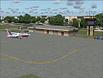
| YALG Adels Grove, Queensland, Australia |
|
Images related to this file:
File Description:
Googlyafcad A&F Data file for Adels Grove, based on Google Earth satellite data.
Unfortunately, Microsoft have omitted this location from Flight Simulator 2004 and this file will allow you and your "AI" traffic to land, taxi, park and take off in a realistic manner.
Adels Grove is a small airstrip serving Lawn Hill National Park, a port of call on the Heron Airlines Northern Affordable Air Tour. The very last commercially operated de Havilland Heron flight called here in 2003 but the service still operates and is now worked by Metroliner aircraft.
These files have been tested with Flight Simulator 2004 default scenery, Visual Australia (VOZ) enhanced scenery and add-on mesh by Andy Weir and is compatible with all. [File re-uploaded at request of AVSIM]
| Filename: | YALG_Adels_Grove_Queensland_Australia.zip |
| License: | Freeware |
| Added: | 20th June 2010, 10:48:26 |
| Downloads: | 412 |
| Author: | John Hinson |
| Size: | 60.12 KB |
| Category: Flight Simulator X - AFCAD Files | |
| Buck's Airport (00N), NJ |
|
File Description:
Located 03 miles NE of Bridgeton, New Jersey on 63 acres of land, Buck's Airport is a small turf field privately owned by J. Di Orio and open to the public. The field in FSX has room for 8 small GA aircraft to park on the square of grass north of the greenhouses. Be careful of the trees to the north and south of the runway.
Scenery constructed with use of Google Maps images, the author has not been there in person.
This scenery is meant to be used in conjunction with MegaScenery Earth New Jersey/Delaware 004. It is not required, but apron use is minimized to allow satellite scenery to show through as much as possible - lack of it may make scenery look out of place.
| Filename: | Bucks_Airport_00N_NJ.zip |
| License: | Freeware |
| Added: | 3rd October 2010, 23:47:29 |
| Downloads: | 233 |
| Author: | Drew Sikora |
| Size: | 566.5 KB |
| Category: Flight Simulator X - Scenery | |
| "The door of Paradise" China |
|
Images related to this file:
File Description:
I wanted to create this scenery of China titled "The Door of Paradise" near Zhangjiajie town, Hunan province, and on top of a mountain there is a striking thirty-meter-deep, deep arch rock-shaped cave , Which scales toward the sky. This unique, rocky rock formation seems to date back to the year 263, when - following a catastrophic event - the back of a cave collapsed leaving a hole in the wall and creating this striking panorama that the Chinese call "the symbol closest to God on earth. " I recommend that you leave Zhangjiajie ZGDY airport and reach the Tianmen Mountain coordinates N 29.03.24 E 110.28.58 where you can watch the door l Paradiso.
For more information on the site search on google. In the Package you will also find instructions for installing the scenery.
| Filename: | The_door_of_Paradise_China.zip |
| License: | Freeware |
| Added: | 17th August 2017, 17:19:37 |
| Downloads: | 752 |
| Author: | Pasquale Marrulli |
| Size: | 16.91 MB |
| Category: Flight Simulator 2004 - Scenery | |
| DGSI Kumasi, Ghana |
|
Images related to this file:
File Description:
Googly scenery for Kumasi - a small domestic airport in Ghana for which no facilities
are provided in Flight Simulator 2004. These scenery files add taxiways, aprons,
buildings and other airport features, so that you and your "AI" traffic can land,
taxi, park and take off in a realistic manner.
The airport serves the city of Kumasi (capital of the Ashanti region) and sees
regular flights using turboprop airliners operated by Accra based operators
Antrak Air and Citylink.
The scenery does not purport to be ultra-accurate. Based on high-detail satellite
imagery from Google Earth, the layout is proportionally correct but the added
airport features, such as buildings, are built from default Microsoft objects
and add-on libraries so will not look like the real thing.
[File re-uploaded at request of AVSIM]
| Filename: | DGSI_Kumasi_Ghana.zip |
| License: | Freeware |
| Added: | 23rd May 2010, 01:25:23 |
| Downloads: | 1,419 |
| Author: | John Hinson |
| Size: | 80.3 KB |
| Category: Flight Simulator X - Scenery | |
| VYYY Yangon Intl Airport Mingaladon V4.0 with Traffic-Pack 1.2 |
|
Images related to this file:
File Description:
Re-upload. DX9 only, compatible with WoAI and MyTraffic. Yangon International Airport "MINGALADON" in Burma, Myanmar, include Traffic-Pack 1.2. Version 4.0 with new dock "G", jetways, already extended runway, taxiways and new taxisigns. First of all we corrected the airport location to the real one. With Myanmar Air Force area, Helipads and even more parkings for civilian airplanes. This scenery was produced based of visit and on pictures of satellites. Many Thanks go to Francisco S���¡nchez-Casta���±er, Fernando Martinez, Mike Stone and the teams of HOUSE-RP in Burma, FSX Planner, SceneGenX, SBuilder X, Open Ports Scanner, AFXBgDownloader, FSUIPC and Google Earth. This scenery is only for FSX, for FS2004 please download vyyy_v2.zip. By HOUSE-RP, Switzerland and Burma
| Filename: | VYYY_Yangon_Intl_Airport_Mingaladon_V40_with_Traff.zip |
| License: | Freeware, limited distribution |
| Added: | 1st June 2010, 01:09:07 |
| Downloads: | 3,732 |
| Author: | HOUSE-RP |
| Size: | 11.04 MB |
| Category: Flight Simulator X - AFCAD Files | |
| ZSHC - Hangzhou Xiaoshan Intl - Hangzhou, China |
|
Images related to this file:
File Description:
Hangzhou Xiaoshan International Airport is the principal airport serving Hangzhou, a major city in the Yangtze River Delta region and the capital of Zhejiang Province, China. The airport is located on the southern shore of Qiantang River in Xiaoshan District and is 27 km east of downtown Hangzhou. Hangzhou is a focus city for Air China, China Southern Airlines and Xiamen Airlines. In 2010, Hangzhou airport handled 17,068,585 passengers and became the 9th busiest airport in China. In addition, the airport was the country's 8th busiest airport in terms of cargo traffic and the 10th busiest airport by traffic movements. From Europe, KLM makes direct flights. Using ADEx 1.55, aeronautical maps and Google Earth the default AFCAD has been updated to reflect today's situation. Please read the Readme file for proper installation.
| Filename: | ZSHC__Hangzhou_Xiaoshan_Intl__Hangzhou_China.zip |
| License: | Freeware |
| Added: | 2nd May 2013, 13:52:13 |
| Downloads: | 1,086 |
| Author: | Menno C. Robert |
| Size: | 722.68 KB |
| Category: Flight Simulator X - Scenery | |
| LRTR Update 1.0 |
|
Images related to this file:
File Description:
-Timisoara RO LRTR V-1 (Released Apr. 2017) for FSX-
This scenery is an update of the stock Airport (ICAO code: LRTR).
What to expect?
The entire airport has been updated with correct RWY, taxiways, aprons, markings, parkings, roads, some buildings, lights and vegetation. All objects are from stock ADE! Entire work and object placing has been done using a photo overlay image from Google Earth, yet don't expect a photoreal scenery. The used background image has been removed due to Google's copyright policy.
Due to using stock objects from library, don't expect perfect shape and colors of objects. I tried to customize the objects so that they look like the real ones. Basic shape and colors should match the real word buildings.
NOTE: Some 3rd party addon's might change ground textures or building textures.
| Filename: | LRTR_Update_10.zip |
| License: | Freeware |
| Added: | 26th March 2017, 20:35:59 |
| Downloads: | 1,430 |
| Author: | Gerald Krutsch |
| Size: | 1.27 MB |
© 2001-2026 AVSIM Online
All Rights Reserved
Privacy Policy |