
Where Flight Simulation Enthusiasts Gather from Around the World!
AVSIM Library - Search Results

| Category: Flight Simulator X - Scenery | |
| SeaTac Area Airports |

|
Images related to this file:
File Description:
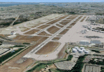
This scenery is a revision of the default Seattle-Tacoma (SeaTac), Boeing Field, Renton and Paine Field airports to work with MegaScenery Earth. The artificial plateau that Seatac is built on has been expanded and the new 3rd runway added. Runways, taxiways and various structures have been revised and/or relocated to match MegaScenery Earth ground textures. Default objects have been used in many cases to minimize FPS impact. MegaScenery Earth Washington-001 (KSEA, KBFI, KRNT) and -002 (KPAE) are required.
| Filename: | SeaTac_Area_Airports.zip |
| License: | Freeware |
| Added: | 11th December 2009, 09:51:46 |
| Downloads: | 5,555 |
| Author: | Al Wheeler |
| Size: | 2.48 MB |
| Category: Flight Simulator X - Scenery | |
| Punta Gorda, FL- Charlotte County Airport (KPGD) |
|
Images related to this file:
File Description:
What appears to be a nearly "dead" airport in FSX is brought to life with scenery objects and air traffic. Generic floating buildings have been replaced with custom and library objects. Landclass changes, roads, rework of runways, taxiways and aprons, placement of library objects and a library of new airport buildings are included. Scenery in this package is based on Virtual Earth (Bing) and Google Earth imagery.
Even though the airport doesn't have a control tower and no gate parking is included in FSX, it does have a terminal and airline traffic in real life. Also, no GA traffic has been observed in FSX other than an occasional aircraft doing a couple of touch-and-gos and moving on. The World of AI traffic file for Allegiant Airlines does not include flights to this airport, so a traffic file is included adding the Allegiant flights as well as some GA flights. The World of AI package is required for the airline flights to display.
| Filename: | Punta_Gorda_FL_Charlotte_County_Airport_KPGD.zip |
| License: | Freeware |
| Added: | 3rd January 2011, 03:06:31 |
| Downloads: | 1,710 |
| Author: | Art Poole |
| Size: | 1.47 MB |
| Category: Flight Simulator 2004 - AFCAD Files | |
| Presidente Nicolau Lobato International, Dili, East Timor (WPDL) v2 |
|
File Description:
"Euraka!" I cried in the middle of the night. My wife rolled over and mumbled "its not me, it must be the cat". But I was pleased with myself, for I had suddenly thought of a way to eliminate Microsoft's radiused corners where taxiway meets runway. They are a nifty arrangement, when you want them, but at this airport (clearly evidenced by Google Earth) they do not exist on the concrete connections. So here is a revised version of my Googlyafcad for WPDL Dili-Comoro-Komoro-Presidente Nicolau Lobato International or whatever it is called today. I considered calling this version 1.0062A so as to impress but I think you might prefer me to call it it version 2. Unfortunately, Microsoft's perception of this airport in Flight Simulator is a wee bit under scale and the ramp areas provided barely allow the parking of a flea, never mind the Boeing 737s that serve this airport. This A&F Data file allows you and "AI" traffic to land, park and take-off in the proper manner. But there is more . . . the Google Earth picture clearly shows three parked
helocopters, so to give the place a little atmosphere, I've provided an additional file which will place three static helicopters at the airport. They will only show if you have the Rwy12 libraries
installed, but the file won't bite if you don't. (replaces af2_wpdl.zip)
| Filename: | Presidente_Nicolau_Lobato_International_Dili_East_.zip |
| License: | Freeware |
| Added: | 12th February 2007, 13:07:25 |
| Downloads: | 750 |
| Author: | John Hinson |
| Size: | 44.33 KB |
| Category: Flight Simulator X - Scenery | |
| W90 - New London Airport - Virginia |
|
Images related to this file:
File Description:
New London Airport (FAA LID: W90) is a public-use airport located six miles (10 km) southwest of the central business district of Forest, a town in Bedford County, Virginia, United States. It is privately owned by Associated Wheels Inc. It is a public airport, but usually involves GA aircraft only. On Sundays during the summer and early fall, the runway is used as a dragstrip. Originally built in 1957 as a 1/4 mile dragstrip, airport operations were added in 1961 and the facility has served a dual-purpose since. Having been under the continued guidance of Rucker Tibbs, the airport changed hands in December 2005. Changes were made based on Google Maps. Created with Airport Design Editor by ScruffyDuck Software using current FAA documentation and Google Earth measurements, this package offers a replacement for FSX's stock airport. All these enhancements are as close to the real airport as I can get with stock library objects and custom buildings.
| Filename: | W90__New_London_Airport__Virginia.zip |
| License: | Freeware |
| Added: | 20th September 2014, 17:31:45 |
| Downloads: | 253 |
| Author: | Wayne Roberts |
| Size: | 233.02 KB |
| Category: Flight Simulator X - Gauges | |
| GPS2020 – V12.0 |
|
Images related to this file:
File Description:
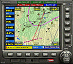
Major upgrade for V10.3, with focus on zooming, Direct-To, inserting waypoints in the flight plan, and User waypoints (waypoints not present in FSX/P3D database).
Key improvements:
- Zooming maps with the mouse wheel now finally like in Google Maps, Google Earth, Bing Maps, Garmin BaseCamp, Little Navmap (FSX utility), etc..
- Direct-To Track Updating: dark red track line continuously follows aircraft movements. For proper operation, the user should install XMLVARS/XMLTools in FSX/P3D (most users will already have done this).
- Visual indication of "Direct-To Active".
- Flight plan: multiple POI's (points clicked on a map) can be inserted in the FPL, they will be named sequentially as TARGET1 to TARGETnnnn.
- Inserting in the flight plan, all sorts of waypoints from all possible sources, can be done with a quicker method with the green buttons alone, without needing to open the Direct-To page.
- Other refinements in code and screen layout since V10.3.
It is recommended to replace V10.3 with this V12.0!
| Filename: | GPS2020__V120.zip |
| License: | Freeware |
| Added: | 29th June 2020, 17:50:18 |
| Downloads: | 560 |
| Author: | Hugo Jansen |
| Size: | 15.7 MB |
| Category: Flight Simulator X - Scenery | |
| Baikonur Cosmodrome (UAON) Plus |
|
Images related to this file:
File Description:
The scenery includes many airports and locations, including UAON and the Baikonur Cosmodrome where Russia launches all spacecraft. The details are stunning. Some airports are gravel, and some are military use only. I am very sorry to report that the author of this excellant work did not credit himself anywhere within the Russia text document included within this zip file. Google translate pulled only little bits of installation data, but no names. Perhaps he was concerned of prosecution, but I commend him in any case. I do not think any of this is illegal in any way based on today's Google Earth data and our ability to see all the things included within this work. It is truly a beautifully done piece of work, and something I have searched for since scenery were available. It was listed as Freeware without restrictions. This a completely previously unknown scenery compilation found through extensive searches and is original in all respects, designed for FSX.
| Filename: | Baikonur_Cosmodrome_UAON_Plus.zip |
| License: | Freeware |
| Added: | 9th November 2019, 21:47:18 |
| Downloads: | 507 |
| Author: | Douglas E. Trapp |
| Size: | 8.36 MB |
| Category: Prepar3D V1-4 - Gauges | |
| GPS2020 – V12.0 |
|
Images related to this file:
File Description:

Major upgrade for V10.3, with focus on zooming, Direct-To, inserting waypoints in the flight plan, and User waypoints (waypoints not present in FSX/P3D database).
Key improvements:
- Zooming maps with the mouse wheel now finally like in Google Maps, Google Earth, Bing Maps, Garmin BaseCamp, Little Navmap (FSX utility), etc..
- Direct-To Track Updating: dark red track line continuously follows aircraft movements. For proper operation, the user should install XMLVARS/XMLTools in FSX/P3D (most users will already have done this).
- Visual indication of "Direct-To Active".
- Flight plan: multiple POI's (points clicked on a map) can be inserted in the FPL, they will be named sequentially as TARGET1 to TARGETnnnn.
- Inserting in the flight plan, all sorts of waypoints from all possible sources, can be done with a quicker method with the green buttons alone, without needing to open the Direct-To page.
- Other refinements in code and screen layout since V10.3.
It is recommended to replace V10.3 with this V12.0!
| Filename: | GPS2020__V120.zip |
| License: | Freeware |
| Added: | 29th June 2020, 17:51:55 |
| Downloads: | 301 |
| Author: | Hugo Jansen |
| Size: | 15.7 MB |
| Category: Flight Simulator X - Scenery | |
| KSAN - San Diego International Airport, San Diego (CA), Photo Real Scenery |
|
Images related to this file:
File Description:

This Photo Real scenery is a complete rebuild for the FSX Default KSAN airport using the latest version of ADE & SBuilderX scenery design tool.
SAN is one of my favorite airports to fly into because of its beautiful scenery, and it is ranked as #10 on the World'����s Most Dangerous Airports list. This scenery includes the new expansion of Terminal 2 that is scheduled to be completed in 2013, but the gates and ground textures are not update yet. I will do a scenery update as soon as those files are available. It also includes new terminal buildings, new buildings located on the RWY 27 approach, and Photo Real ground textures that gives the airport a more realistic feeling. I have added some Google Earth buildings, new warehouses, and several nice scenery enhancements. The runways and airport aprons are aligned to match Google & Yahoo satellite imagery. I hope you enjoy the scenery.
| Filename: | KSAN__San_Diego_International_Airport_San_Diego_CA.zip |
| License: | Freeware |
| Added: | 29th October 2011, 02:07:18 |
| Downloads: | 11,005 |
| Author: | Glenn Johnson |
| Size: | 33.37 MB |
| Category: Prepar3D V1-4 - Flight Plans | |
| GA, AI Traffic for ORBX TRUE EARTH SOUTH with extras |
|
File Description:
Original file plus Additions to Version 1 = Flightplans and also Airfields adjusted for no pushback and increased parking.= LEICESTER ,CAMBRIDGE, STAPLEFORD, WOLVERHAMPTON, COVENTRY, OLD BUCKENHAM, TATENHILL and ALDERNEY. 4 new aircraft available for "G"reg. Bristol 2019(UK2000) amended.
Caernarfon and Valley (although Central ORBX) are included.
For SODE users - windturbines(varying with windspeed) for EGCK.
SODE deicing updated for EGGD to avoid parked aircraft.
Required to enable the G" reg aircraft is - ORBX FREEWARE- AI NA GA TRAFFIC. (Available from ORBX central/North America)
| Filename: | GA_AI_Traffic_for_ORBX_TRUE_EARTH_SOUTH_with_extra.zip |
| License: | Freeware, limited distribution |
| Added: | 5th January 2020, 16:59:37 |
| Downloads: | 201 |
| Author: | john watts |
| Size: | 4.1 MB |
| Category: Flight Simulator X - Scenery | |
| SKAR (Aeropuerto El Eden, Armenia, Colombia) |
|
File Description:
This file is the airport with the airport buildings. It is done using google map.
| Filename: | SKAR_Aeropuerto_El_Eden_Armenia_Colombia.zip |
| License: | Freeware |
| Added: | 15th June 2010, 04:15:39 |
| Downloads: | 490 |
| Author: | Anwar Gonzalez |
| Size: | 8.44 KB |
© 2001-2026 AVSIM Online
All Rights Reserved
Privacy Policy |