
Where Flight Simulation Enthusiasts Gather from Around the World!
AVSIM Library - Search Results

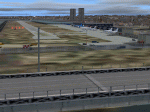
| Category: Flight Simulator 2004 - AFCAD Files | |
| KDCA v0512 |

|
Images related to this file:
File Description:

KDCAv0512 zip contains 2 bgl's (1 afcad and 1 for building placement).
This is a complete redo of the AP.
I used Google Earth for measurements, the current airport diagram, and info from the KDCA website for current gate assignments.
Created with AFX and ISv2 for FS9 ONLY to replace the default AP.
Have Fun, Joe
| Filename: | KDCA_v0512.zip |
| License: | Freeware |
| Added: | 2nd June 2012, 22:34:53 |
| Downloads: | 584 |
| Author: | Joe Bourgeois |
| Size: | 10.85 KB |
| Category: Flight Simulator 2004 - Scenery | |
| London City LCY EGLC Light |
|
Images related to this file:
File Description:
London City LCY EGLC Light scenery FS9. Simple, but custom terminal building and RWY12 objects. New apron platform and building, opened 2008. Corrected coast line (FS9 version only), RWY/TWY and position of the dock. Connaught Bridge, Sir Steve Redgrave Bridge, Woolwich Manor Way Bridge (standard FS bridges). Positions taken from Google Earth. By Gernot Zander, 2010-02-07.
| Filename: | London_City_LCY_EGLC_Light.zip |
| License: | Freeware |
| Added: | 7th February 2010, 11:15:16 |
| Downloads: | 2,581 |
| Author: | Gernot Zander |
| Size: | 1.22 MB |
| Category: Flight Simulator X - Scenery | |
| 7FL6 Spruce Creek Fly-in Community |
|
Images related to this file:
File Description:

Touted as the worlds most famous residential airpark, this airfield resides within the Daytona Beach International Airport (KDAB) controlled airspace. More information is available at www.7fl6.com. The scenery includes photo landclass changes, rework of the runway, taxiways, aprons and parking; custom scenery objects and placement of library objects. Scenery in this package is based on Virtual Earth (Bing) and Google Earth imagery and photos taken locally. The package includes airport arrival-departure procedures (PDF) published by the Fly-in and scenery associated with the VFR "Tank Departure".
| Filename: | 7FL6_Spruce_Creek_Flyin_Community.zip |
| License: | Freeware |
| Added: | 13th July 2012, 05:40:50 |
| Downloads: | 1,029 |
| Author: | Art Poole |
| Size: | 5.13 MB |
| Category: Flight Simulator X - Scenery Design | |
| Man2SBuilder |
|
File Description:
Re-upload. These small and simple to use utilities will rename image tiles downloaded from Google Earth and Microsoft Virtual Earth using the Manifold tool bar so that they can be displayed with the latest version of SBuilder X.
SBuilder X now has its own tile server, and so one no longer needs the Manifold tool bar in order to get images.
I am unable, for lack of free time, to offer support of any kind. For questions or problems, please post in the Avsim scenery design forum.
| Filename: | Man2SBuilder.zip |
| License: | Freeware |
| Added: | 28th May 2010, 02:21:02 |
| Downloads: | 2,443 |
| Author: | Luis Feliz-Tirado |
| Size: | 88.6 KB |
| Category: Flight Simulator X - Scenery | |
| St. Augustine, FL - Northeast Florida Regional Airport (KSGJ) |
|
Images related to this file:
File Description:
Generic floating buildings have been replaced with custom and library objects, and the attached seaplane base is included with a functional ramp to the water. FSX does not include the water runways on the intercoastal waterway, but information from the St. Augustine-St. Johns County Airport Authority is included showing the runway locations. Scenery in this package is based on Virtual Earth (Bing) and Google Earth imagery. Landclass changes, roads, rework of taxiways and aprons, placement of library objects and a library of new airport buildings are included.
| Filename: | St_Augustine_FL__Northeast_Florida_Regional_Airpor.zip |
| License: | Freeware |
| Added: | 22nd September 2010, 02:31:03 |
| Downloads: | 1,754 |
| Author: | Art Poole |
| Size: | 1.59 MB |
| Category: Orbiter - Miscellaneous Files | |
| Earth Moon MFD (Full Color) |
|
File Description:
Earth Moon MFD Maps (Full Color)
Credits:
Special Thanks goes to the Visible Earth team for providing the imagery:
http://visibleearth.nasa.gov/
Additional thanks and credit goes to the Earth Observatory team for developing the imagery:
http://earthobservatory.nasa.gov/
Luna Map:
http://maps.jpl.nasa.gov/
Note to Tile Developers: look at the EarthTDK (Tile Development Kit)
The image files in that addon will contain the highest resolution global maps of the planet Earth every made. Thanks again to the fantastic team at Blue Marble, Visible Earth, and Earth Observatory.
Possible upgrades to this will be discussed in a text file released with the EarthTDK (For further details).
| Filename: | Earth_Moon_MFD_Full_Color.zip |
| License: | Freeware |
| Added: | 17th December 2002, 17:39:28 |
| Downloads: | 3,227 |
| Author: | Seth Hollingsead |
| Size: | 137.44 KB |
| Category: Orbiter - Miscellaneous Files | |
| High Resolution Earth Nightlight Texture |
|
File Description:
A high resolution version of Earth at night, using night time maps supplied by http://visibleearth.nasa.gov/cgi-bin/viewrecord?582
| Filename: | High_Resolution_Earth_Nightlight_Texture.zip |
| License: | Freeware |
| Added: | 7th November 2003, 03:56:21 |
| Downloads: | 1,648 |
| Author: | Jim Williams |
| Size: | 512.55 KB |
| Category: Orbiter - Miscellaneous Files | |
| Space-Graphics.com 040125 Earth Texture |
|
File Description:
A new version of the Space-Graphics.com Earth texture was released and named the E43 Earth maps. I have converted them for use with Orbiter. Both levels 8 and 9 included.
| Filename: | SpaceGraphicscom_040125_Earth_Texture.zip |
| License: | Freeware |
| Added: | 26th January 2004, 05:47:06 |
| Downloads: | 1,073 |
| Author: | Kevin M Stoffel. |
| Size: | 23.36 MB |
| Category: Flight Simulator X - Aircraft Repaints, Textures and Modifications | |
| Boeing 737-800 Earth Day |
|
File Description:
A texture of Earth Day celebrated the 22th of April.
| Filename: | Boeing_737800_Earth_Day.zip |
| License: | Freeware |
| Added: | 23rd April 2010, 02:09:46 |
| Downloads: | 126 |
| Author: | Jorge Correia |
| Size: | 7.12 MB |
| Category: Flight Simulator 2004 - Scenery | |
| Mustang Airport, (2CL9) Galt, California |
|
File Description:
This is a scenery upgrade for Mustang Airport, Galt, California (2CL9) Part Eleven of a series of small airstrip and minor airfield scenery enhancements which are based on real world data from Google Earth.
Again just a small Hanger and some other building seem to make up the airstrips buildings but the strip itself (which is a remarkable 4000ft long!) is surrounded by a very regular group of fields divided by dirt roads, this is visible both from google and the airnav shot, consequently I have made the scenery to try and match this.
| Filename: | Mustang_Airport_2CL9_Galt_California.zip |
| License: | Freeware |
| Added: | 6th April 2006, 05:00:33 |
| Downloads: | 476 |
| Author: | Kim Gowney |
| Size: | 127.02 KB |
© 2001-2026 AVSIM Online
All Rights Reserved
Privacy Policy |