
Where Flight Simulation Enthusiasts Gather from Around the World!
AVSIM Library - Search Results

| Category: Flight Simulator X - Miscellaneous Files | |
| Detailed Default Airports for Google Earth |

|
File Description:
This kml-File will show you all the airports which are detailed by default FSX. You can use it with Google Earth.
| Filename: | Detailed_Default_Airports_for_Google_Earth.zip |
| License: | Freeware, limited distribution |
| Added: | 19th May 2014, 13:38:26 |
| Downloads: | 353 |
| Author: | Mirco Gut |
| Size: | 9.08 KB |
| Category: Flight Simulator X - Utilities | |
| Making Landclass Files Using Google Earth |
|
File Description:
This is a short set of instructions for how to make landclass files using Google Earth.
| Filename: | Making_Landclass_Files_Using_Google_Earth.zip |
| License: | Freeware |
| Added: | 21st December 2010, 07:16:41 |
| Downloads: | 1,317 |
| Author: | Eric G Hansen |
| Size: | 691.31 KB |
| Category: Flight Simulator X - Utilities | |
| Yet Another Google Earth Tool (FSX) |
|
File Description:
This little program for FSX allows to save two types of file : a single position file and a complete path file for Google Earth program (Each leg of the path is ~1NM long). It also allows to create a direct link between a Google Earth window and an instance of FSX and to follow your position on the Google view (it uses new SDK MS SimConnect.dll)
| Filename: | Yet_Another_Google_Earth_Tool_FSX.zip |
| License: | Freeware |
| Added: | 18th October 2006, 19:59:35 |
| Downloads: | 2,527 |
| Author: | laurent claude |
| Size: | 945.02 KB |
| Category: Flight Simulator X - Miscellaneous Files | |
| Flight Simulator X in Google Earth |
|
File Description:
This zip contains all the airports & navaids for Flight Simulator X and includes all comms and nav frequencies, runway details along with any relevant ILS information. Extracted from the default FSX BGL scenery files in Nov 2006.
| Filename: | Flight_Simulator_X_in_Google_Earth.zip |
| License: | Freeware |
| Added: | 16th November 2006, 20:53:45 |
| Downloads: | 9,763 |
| Author: | Ian Niblo |
| Size: | 2.16 MB |
| Category: Flight Simulator 2004 - Scenery | |
| Google Earth Scenery Database for New Zealand |
|
Images related to this file:
File Description:
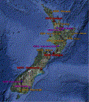
This is a .kmz file showing most of the amazing FS9 sceneries available for NZ (75 or so).
Just double-click on the file and they should show up in GE. Airports are categorised, so you can accurately filter by airport type. Download links are provided for each, as well as a link to a screenshot.
Makes planning a flight a little easier, and perhaps more interesting, as you can often zoom down to street view in GE, and see what the airport looks like!
| Filename: | Google_Earth_Scenery_Database_for_New_Zealand.zip |
| License: | Freeware |
| Added: | 30th March 2011, 01:09:13 |
| Downloads: | 374 |
| Author: | Charl du Toit |
| Size: | 17.54 KB |
| Category: Flight Simulator 2004 - Utilities | |
| Flips 1.1 - view flightplans in Google Earth |
|
File Description:
Flips is a small utility to view FS9 flightplans in Google Earth.
View your entire flightplan in 3D and make sure your chosen waypoints don't let you
miss exiting landmarks along your flight.
Updated version 1.1 now supports 3 variations in FS9 flightplan formats and should fix a couple of read errors. More drawing options, improved help and sample flightplans included.
| Filename: | Flips_11__view_flightplans_in_Google_Earth.zip |
| License: | Freeware |
| Added: | 21st September 2005, 14:11:26 |
| Downloads: | 8,476 |
| Author: | Michael Rook |
| Size: | 1013.34 KB |
| Category: Flight Simulator 2004 - Utilities | |
| Yet Another Google Earth Tracking Tool (v0.91) |
|
File Description:
This little program for FS9 allows to save two types of file : a single position file and a complete path file for Google Earth program (Each leg of the path is ~1NM long). It also allows to create a direct link between a Google Earth window and an instance of FS9 and to follow your position on the Google view.
NB : it uses FDSConnection v1.3 a free FSUIPC like interface (see http://www.flightdecksoftware.com)
| Filename: | Yet_Another_Google_Earth_Tracking_Tool_v091.zip |
| License: | Freeware |
| Added: | 9th September 2006, 23:29:05 |
| Downloads: | 664 |
| Author: | laurentC |
| Size: | 746.92 KB |
| Category: Flight Simulator X - Utilities | |
| GETCha (Google Earth Taxi Chart Generator) v1.1 |
|
Images related to this file:
File Description:
This is a simple utility to draw airport taxiway chart to view with Google Earth, using Flight Simulator's AFCAD data. It can generate taxiway chart of any airport in the world (as long as it exists in FS). If it's hard or troublesome for you to find taxiway charts of all the airports you visit, this utility can be helpful.
| Filename: | GETCha_Google_Earth_Taxi_Chart_Generator_v11.zip |
| License: | Freeware |
| Added: | 8th October 2012, 19:42:27 |
| Downloads: | 629 |
| Author: | Dongjin Shin |
| Size: | 4.93 MB |
| Category: Flight Simulator 2004 - Miscellaneous Files | |
| All fs9 airports in Google Earth format |
|
File Description:
All fs9 24014 airports in Google Earth format. Very useful to prepare an approach or a flight plan.
| Filename: | All_fs9_airports_in_Google_Earth_format.zip |
| License: | Freeware |
| Added: | 19th June 2007, 00:11:31 |
| Downloads: | 5,867 |
| Author: | Pierre Legault |
| Size: | 1.35 MB |
| Category: Flight Simulator 2004 - Utilities | |
| Yet Another Google Earth Tool (v0.9) for FS9 |
|
File Description:
This little program for FS9 allows to save two types of file : a single position file and a complete path file for Google Earth program. (Each leg of the path is ~1NM long)
NB : it uses FDSConnection v1.3 a free FSUIPC like interface
(see http://www.flightdecksoftware.com)
| Filename: | Yet_Another_Google_Earth_Tool_v09_for_FS9.zip |
| License: | Freeware |
| Added: | 9th September 2006, 12:33:13 |
| Downloads: | 392 |
| Author: | laurentC |
| Size: | 658.74 KB |
© 2001-2026 AVSIM Online
All Rights Reserved
Privacy Policy |