
Where Flight Simulation Enthusiasts Gather from Around the World!
AVSIM Library - Search Results

| Category: Flight Simulator X - AFCAD Files | |
| Linden Airport (KLDJ), NJ v1.1 |

|
File Description:
Located 01 miles SE of Linden, New Jersey on 188 acres of land, Linden Airport is a public asphalt strip 4137' in length. Numerous changes have been made to this airport to bring it closer to its real-life counterpart including proper non-precision runway markings for R09 while only basic markings are used for R27; The 4-box VASI has been accurately located; the traffic pattern height has been adjusted; All 130 tiedown locations have been accurately placed. RAMP_GA spots are taken by static aircraft (all of which have collision disabled) so they should not be selected unless you want to start inside another aircraft! RAMP_GA_SMALL spots can be occupied by aircraft with wingspans up to 40 feet and RAMP_GA_MEDIUM spots can be occupied by aircraft with wingspans up to 60 feet. There are 4 open hangars labeled as GA_DOCK. The main hangar (NW Parking) can hold aircraft with wingspans up to 60 feet. The three smaller hangars (SW Parking) can hold aircraft with wingspans up to 35 feet. The W Helipad start location will put you in front of the smaller main tarmac hangar within the coned-off section. Fuel is only available by taxiing to a stop in front of either fuel tank to the west of the main tarmac. No AI aircraft will spawn in the SW Parking area.
Scenery constructed with use of satellite images/streetview/aerial photos - the author has not been there in person.
This scenery is meant to be used in conjunction with MegaScenery Earth New York 005. It is not required, but apron use is minimized to allow satellite scenery to show through as much as possible, and objects are placed based on the MSE textures - lack of it may make scenery look out of place.
| Filename: | Linden_Airport_KLDJ_NJ_v11.zip |
| License: | Freeware |
| Added: | 28th June 2011, 00:03:41 |
| Downloads: | 511 |
| Author: | Drew Sikora |
| Size: | 1.23 MB |
| Category: Flight Simulator X - AFCAD Files | |
| Ekdahl Airport (NJ59), NJ |
|
File Description:
Located 04 miles S of Freehold, New Jersey, Ekdahl Airport is a private turf strip 1300' in length bordered closely by trees. This makes for an interesting landing as the 90' width of the runway is all the room you have to play with. However because it can be difficult to gauge your distance to trees and also because even the slightest brush with a tree can cause a crash, all trees immediately adjacent to the runway have crash disabled - mainly so you can turn your plane around if you land on Runway 02. The hard surface runway was removed so make sure your terrain mesh complexity is set as high as possible to get that bumpy ground realism. A windsock is listed as being available on this field but I could not locate it in any imagery and so placed it by default near the hangar building. You can start on the runways or parked in front of the hangar. Make sure your plane is capable of these take off and landing distances! Tree height around the field was not listed so I again used my best judgement from studying aerial photos. There is no fuel or parking for transient aircraft available. The field is not lit - daytime VFR operations only are recommended.
Scenery constructed with use of satellite images/streetview/aerial photos - the author has not been there in person.
This scenery is meant to be used in conjunction with MegaScenery Earth New Jersey/Delaware 002. It is not required, but apron use is minimized to allow satellite scenery to show through as much as possible, and objects are placed based on the MSE textures - lack of it may make scenery look out of place.
| Filename: | Ekdahl_Airport_NJ59_NJ.zip |
| License: | Freeware |
| Added: | 13th August 2011, 16:53:55 |
| Downloads: | 172 |
| Author: | Drew Sikora |
| Size: | 550.03 KB |
| Category: Flight Simulator X - AFCAD Files | |
| Peters Airport (4NJ8), NJ v1.1 |
|
File Description:
Located 05 miles W of Somerville, New Jersey on 70 acres of land, Peters Airport is a private turf strip that will test your short field skills to the max. The published runway dimensions for this strip are 1700x200 feet, and for the most case this is fairly accurate - however at the ends of both runways you have tree obstacles to overcome so this can shorten the amount of usable runway significantly, although the tree obstacles are no higher than 12-14m. There is no hardened runway surface so you will be landing/taking off on terrain. Depending on how high your mesh resolution is, this can be a significant factor, as Runway 31 is mainly uphill enough that you will need to power up with parking brakes on if you want to make it in the air. Runway 13 is the best since you are going downhill and the trees at the end are fewer and smaller. Pay close attention to the pattern! Runway 13 is Left and Runway 31 is Right - this airport is within 2 miles of Solberg-Hunterdon (N51) and you don't want to get in the way of that field's traffic! The runway is not lit, so daytime VFR operations only. There are no services at this strip for transient aircraft.
Scenery constructed with use of satellite images/streetview/aerial photos - the author has not been there in person.
This scenery is meant to be used in conjunction with MegaScenery Earth New Jersey/Delaware 001. It is not required, but apron use is minimized to allow satellite scenery to show through as much as possible, and objects are placed based on the MSE textures - lack of it may make scenery look out of place.
| Filename: | Peters_Airport_4NJ8_NJ_v11.zip |
| License: | Freeware |
| Added: | 20th September 2011, 14:08:43 |
| Downloads: | 405 |
| Author: | Drew Sikora |
| Size: | 461.03 KB |
| Category: Flight Simulator X - Scenery | |
| 2 Fronson Hangars |
|
Images related to this file:
File Description:
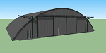
This model was created to be placed in FSX as airport scenery using Airport Design Editor.
I created it for my own use when i was re-creating RNAS HMS Nuthatch which was a Naval Airstation near Anthorn on the Solway Coast in Cumberland (now Cumbria), United Kingdom.
History of RNAS HMS Nuthatch...
Work began on building an airfield at Anthorn for the Fleet Air Arm in late 1943, with Royal Naval Air Station Anthorn, or HMS Nuthatch opening on 7 September 1944, with three tarmac runways.
It was the base of No. 1 Aircraft Receipt and Despatch Unit (No. 1 ARDU), which had the job of receiving aircraft fresh from manufacturers, modifying them to Service standards and despatching them to operational squadrons, with the unit specialising in the Vought F4U Corsair.
No. 1 ARDU continued to operate from Anthorn following the end of the Second World War, while a number of Fleet Air Arm Squadrons were also based at the airfield in the immediate post war years.
The airbase shut down in March 1958.
The Airfield is now the site of a VLF/LF transmitter used for transmitting orders to Submarines, it is also home to three atomic clocks for transmitting Britains time signal transmissions.
None of the Hangars (11 Pentad and 22 Fromson) survive at the site but their concrete standings are still visable.
Depicted here are representations of the Fromson type hangers created from dimensions in a 1947 survey.
I created the model using Google Sketchup and converted it for use in FSX using Model ConverterX.
This is my 1st attempt at scenery creation and is therefore pretty basic.
There are no known issues and it works fine in FSX.
| Filename: | 2_Fronson_Hangars.zip |
| License: | Freeware |
| Added: | 8th June 2014, 07:13:54 |
| Downloads: | 251 |
| Author: | Mark John Byers |
| Size: | 1.4 MB |
| Category: Flight Simulator X - Scenery | |
| Carnes Farm |
|
Images related to this file:
File Description:
These are the files that I talked about in the Prepar3d forums. I created these objects for Fs9, then upgraded them to the scenery SDK for FSX. They were created 10 years ago in GMAX, and I have used them successfully ever since in Prepared 1.4 as well.
For some reason the individual farmhouse and other objects that I created are not showing up in Prepar3d version 2.0.
That's where you guys come in! These files are free to use in anyway you want as long as proper attribution is given, but, I would like you guys who have both Prepar3d 1.4 and 2.0 to try them out in both and report back to me as to whether you have the same problems that I do. That's your only fee. And I'd like you guys to give it a shot in both, or all four( I am not sure that they will work in FS9 anymore, but try it out. Unfortunately I can't recompile my FSX SDK Files back to FS9 if it doesn't work).
What's included:
1. Photo real scenery of Barbourville, 10 miles to the north west of stinking Creek where we live, and;
2. Photo real scenery of the farm area and stinking Creek, upon which I have placed my GMAX objects;
A. The farm house.Carnes Farm From the Bridge at 500 AGL.jpg
B. The barn, shed and the RV in back of the farmhouse.
C. A two-story long structure the top of which is an apartment but the bottom of which is a re-creation of Mama Carne's store, along with all the real wood floors shelves and original contents.. It is also o n Google earth in 3-D as it is here with further description .
... A little note on Gmax.. Mama Carne's store was one the first structures that I built in Gmax. It was just a box. Later, I added the true architectural features that you see including the steps and rails which took about as long to create as it would have to Saw and fit and hammer the real rails, risers and steps.
D. K-6, my little 2300 foot strip for runways 03 and 21. It has VOR - (117.55), ILS(110.1), and NDB(222).
E. Gerald Bingham's house, 1/4 mile up Warriors Path North from us.( mostly dirt road with gravel topping).
F. Dewitt Baptist Church.
Off property Knox county
G.Escoe's Store and Post Office complete with great prices for gas at the included pumps.
Escoes.jpg
H. Rex allen's killer corner...sheds and farm equipment on the sharpest bend on Stinking Creek...my son went off it with a flat tire, unscathed, but more than several have lost their lives on that curve... there may be several iterations of the sheds...just delete or rename the wrong ones...I was experimenting with ModelConverterX, Arno Gerretsen's wonderful model and object scenery tool.
I. sitting on top of the Barbourville Photo real scenery Barbourville PhotoReal over the shopping center.jpg is the Barbourville P3D Shopping Center2.jpg shopping center all the stores and all the storefronts ... it's on 25 E. as you head into Barbourville.
Recreated, is the entire shopping center with the now outmoded Wal-Mart sign. Probably my magnum opus.
note on the Gmax scenes.
All of the scenery was either directly measured and if not practical for a such a long measuring device, walked off, as in the Stinking Creek Bridge and shopping center. All of the objects were then photographed, in 360° where possible and saved as texture for inclusion in the Gmax model.
Enjoy!
...oh... how do you get there? Wellllll.... situate yourself at Middlesboro (1a6), and tune your Nav radio to K-69's VOR, 117.55, take off and climb to 3500 feet...grinnnnn
Welcome to Knox County Kentucky!
| Filename: | Carnes_Farm.zip |
| License: | Freeware |
| Added: | 2nd December 2013, 05:34:20 |
| Downloads: | 453 |
| Author: | Chas Honce |
| Size: | 91.13 MB |
| Category: Flight Simulator 2004 - Scenery | |
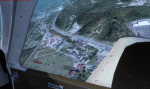
| Stephenville CYJT in Newfoundland Canada |
|
Images related to this file:
File Description:
Stephenville is on the east coast of Canada, and the airport was an American base from 1941, when it was built, until 1966. It was named the "Ernest Harmon Airforce Base" and I will leave that for you to research if you wish to know more. Operating in my version (around 2010?) as a civilian airport, it's main features are a long 10,000 feet 09-27 runway (with ILS on 27) and acres of empty space. The runway was one of those designated as an emergency space shuttle landing runway if required. There is a shorter 20-02 runway (3,000 feet) that is not maintained during the winter (and which would be closed in 2018). The revised perimeter fence of the airport now encloses less than half of the original area, with the northern parts replanned as an industrial park. The attached screenshot from Google Earth shows this, and also that the main operating part of the airport is at the western end of the main runway, with only one hangar connecting to the runway from the eastern end. Like Gander, the airport is still shrinking, with taxiways and aprons not maintained (particularly in the winter) or even formally closed, and flight numbers falling. Until the early 1990's Stephenville was serving most of western Newfoundland and Air Canada, for instance, was one of the airlines that flew there. Deer Lake took over this task for western Newfoundland when the Provincial Government so decided. Stephenville remains as a port of entry, and planes with a total of 30 or less passengers can still be serviced there. My version is a mixture that cannot be precisely dated. For instance, I know there was a large hangar there until 2013 but as I do not have any photos to make it I have shown only the concrete square where it formerly stood. So 2008 or 2013, or somewhere in between? I have the airport being served by Provincial Airlines and also by Porter, though in fact Porter only flew there during the Summer months; I say "flew" as right now all flights are of course almost totally non-existent. As with Gander, I have made it clear which of the taxiways and aprons are still in regular use by showing them as asphalt, while those in the process of decaying disuse or removal are in the darker gravel or tarmac textures; this is somewhat realistic as when asphalt aprons are "ploughed" for removal the darker underside becomes visible. I have also shown the areas that now form part of the Industrial Park as cement, as this better matches the Ultimate Terrain road texture. It may seem odd that the new Canadian Coastguard hangar is not properly served by an asphalt taxiway instead of sitting on an apron that is not cleared in the winter, but it caters (mainly?) for helicopters. The original coastguard hangar is the large and decrepit one in the northeastern corner of the airport. Almost all of the buildings within the original perimeter of the airport are fairly accurately replicated here, whether still in use (Road Maintenance Department, Garbage Disposal, Armour Trucking Company, etc) or vacant (including the very strange atom-bomb-proof buried shelter) or still part of the airport (the east side of the main apron with Shell to the north, then the terminal, the Marine Institute, etc). The AI included here (a revised Gander AI) is for daily flights by Provincial Airlines, Porter, and some charter planes and GA. You will see, once the scenery is installed, that like Gander there two scenery folders called "Scenery summer" and "Scenery winter". Obviously in August you will want the summer scenery and you get this by editing the folder name down from "scenery summer" to just "scenery" and FS9 loads the summer ground textures. If FS9 decides that there is snow on the ground then you need the winter textures which do not show the aprons or taxiways that do not receive winter maintenance. One thing you must NOT DO is to edit both folders down at the same time.
| Filename: | Stephenville_CYJT_in_Newfoundland_Canada.zip |
| License: | Freeware, limited distribution |
| Added: | 24th June 2020, 18:01:58 |
| Downloads: | 233 |
| Author: | Roger Wensley |
| Size: | 43.78 MB |
| Category: Flight Simulator 2004 - Scenery | |
| Tok Junction 6K8 in Alaska, USA |
|
Images related to this file:
File Description:
Tok Junction is a village, or small town, on the Alaska Highway some 180 miles east of Fairbanks and 60 miles west of the Alaska-Canada border. The town is spread over a wide area on the flat terrain and barely registers among the trees, and as such is not shown in FS9 except as a grid of roads as there is no town terrain texture like it used in FS9. The airfield is at the eastern end of the town and adjacent to the Alaska Highway and I have included some surrounding houses, workshops, shops, lodges, etc. The single runway is 3,000 feet of 50 feet wide asphalt aligned 07-25 and lit. There is a small airline based on the airfield called 40-Mile Air. Their hangar is red and the name written large and 100LL fuel is available beside it at all times. Jet A-1 is available by a telephoned pre-arangement. They are, I believe, no longer flying scheduled flights but they do still function as an air taxi and they have a contract to deliver mail to surrounding villages that are not served by all-weather roads. The airfield now has a new icao "PFTO" but in FS9 it remains as the original FAA LID, 6K8. The FS9 roads are not accurately placed, and the grass airfield background is not really appropriate as the reality is more like gravel mixed with earth; it is however difficult to replicate this with the available textures and still prevent bushes or trees appearing. But, in the winter and with snow on the ground it looks as it should. A note here about my scenery making. There will not be many more to follow this as I am almost at the end of the photos I either took or found for scenery purposes, plus I expect to move on from FS9 at some point during next year.
| Filename: | Tok_Junction_6K8_in_Alaska_USA.zip |
| License: | Freeware, limited distribution |
| Added: | 14th January 2020, 17:49:21 |
| Downloads: | 176 |
| Author: | Roger Wensley |
| Size: | 25.47 MB |
| Category: Flight Simulator X - AFCAD Files | |
| Spitfire Aerodrome Airport (7N7), NJ |
|
File Description:
Located 02 miles S of Pedricktown, New Jersey on 48 acres of land, Spitfire Aerodrome Airport is a public asphalt single-strip field that allows transient craft to tie down on the apron. There are also helicopters based here on this field (note there is no Jet-A fuel available) so the helicopter start location will place you on the ramp.
Although this airport has a beacon, FSX for some reason does not include one with the stock airport file and I can't yet create rotating beacons so it is there and lit at night but does not rotate and is not as visible as the rotating ones. This will be addressed in a later update. Also take note of the layout of this airport, it requires that AI traffic cross the runway in order to taxi to either end for take off. AI aircraft DO NOT hold short when taxiing across runways (this is an FSX limitation), so use extreme caution on approach and departure to avoid any unfortunate runway incursions. Aircraft can fuel up by parking near the fuel truck beside the hangar south of the runway. If you have trouble locating the windsock, look on top of the hangar roof north of the runway. The crashed aircraft in the pond is fictional, there is a distinctive airplane-shaped object there in the satellite textures but I could not determine what this might be from aerial photos so I just crashed a plane there for kicks :)
Scenery constructed with use of satellite images/streetview/aerial photos - the author has not been there in person.
This scenery is meant to be used in conjunction with MegaScenery Earth New Jersey/Delaware 004. It is not required, but apron use is minimized to allow satellite scenery to show through as much as possible, and objects are placed based on the MSE textures - lack of it may make scenery look out of place.
| Filename: | Spitfire_Aerodrome_Airport_7N7_NJ.zip |
| License: | Freeware |
| Added: | 11th February 2011, 15:29:36 |
| Downloads: | 241 |
| Author: | Drew Sikora |
| Size: | 833.54 KB |
| Category: Flight Simulator X - AFCAD Files | |
| Sussex Airport (KFWN), NJ |
|
File Description:
Located 01 miles SW of Sussex, New Jersey on 96 acres of land, Sussex Airport is a public asphalt strip 3515' in length. The airport is not in the best of condition and there are no markings on the taxiways. The taxiway south of the hangar towards the end of Runway 03 is closed indefinitely due to disrepair. You will have to back-taxi on the runway if you need more room to take off. Hangars and tiedowns are both available to aircraft with wingspans of 40' or less. Anything bigger will have to find a spot in the large empty area of the tarmac and make sure if you're starting out with something larger you start on the runway or in the one MEDIUM_GA parking spot. Hangar parking is identified by DOCK parking types. North Parking is located in the grass tiedown area and regular Parking is located on the main tarmac. South Parking is the one hangar towards the end of Runway 03. Jet-A fuel is available from parking in front of the fuel truck by the terminal building or in either of the hangar spots. Collision is disabled with all static aircraft to make it easier to park between them if you choose a tiedown instead of a hangar. REIL and approach lighting for Runway 03/12 are out of service indefinitely as is the approach lighting for Runway 03. The traffic pattern height has been changed to 1220' MSL (heavy aircraft use 1420').
Scenery constructed with use of satellite images/streetview/aerial photos - the author has not been there in person.
This scenery is meant to be used in conjunction with MegaScenery Earth New York 006. It is not required, but apron use is minimized to allow satellite scenery to show through as much as possible, and objects are placed based on the MSE textures - lack of it may make scenery look out of place.
| Filename: | Sussex_Airport_KFWN_NJ.zip |
| License: | Freeware |
| Added: | 9th May 2011, 09:02:01 |
| Downloads: | 317 |
| Author: | Drew Sikora |
| Size: | 1.09 MB |
| Category: X-Plane - Scenery | |
| Susi Air Sceney Package Indonesia East Timor v1.0.0 |
|
Images related to this file:
File Description:

This is an X-Plane 11 scenery package in Indonesia and East Timor, 30 airfields in total, all of them are destinations for "PT ASI Pujiastuti Aviation", operating as Susi Air, an Indonesia airlines established in late 2004 by Mrs. Susi Pudjiastuti. Ideal for bush flight lovers, who like to have new challenges outside of the box. Susi Air is pictured in the 2014 TV mini-series "Worst Place to be a Pilot", that follows the highs and lows in the lives of the young British pilots who work for Susi Air, as they fly and land their planes in some of the most breath-taking, remote and dangerous locations on earth. For more info, search for "Worst Place to be a Pilot" in YouTube. This scenery package was tested and is operational (as of January 21, 2017) in "X-Plane 11 Public Beta #8 64 bit", Windows 10 Home. It is meant, primarilly, for XP11 use. However, it was also tested and is partially operational (as of January 21, 2017) in "X-Plane 10.51 64 bit", Windows 10 Home. Most of them will work 100% well in XP10, but a few of them will present mesh issues, once XP11 mesh is improved before the old XP10 mesh files.
List of airfields:
- WA0B Susi Air Idedua Airstrip
- WABI Susi Air Nabire
- WABP Susie Air Timika
- WABX Susi Air Bilai Airstrip
- WAJD Susi Air Wakde Airstrip
- WAJJ Susi Air Jayapura
- WAJW Susi Air Wamena Airport
- WICN Susi Air Headquarters
- WIHH Susi Air Jakarta
- WIPB Susi Int'l Pangandaran Beach Airstrip
- WPDL Dili International Airport
- WT17 Susi Air Siriwo Airstrip
- WT66 Susie Air Wewak Airstrip
- WT75 Susi Air Yogosem Airstrip
- WW01 Susi Air Makki Airstrip
- WW32 Susi Air Nevere
- WW56 Susi Air Pass Valley Airstrip
- WW68 Susi Air Pogapa Airstrip
- WX15 Susi Air Apowo Airstrip
- WX37 Susi Air Beoga Airstrip
- WXAR Susi Air Armopa Road Airstrip
- WXPJ Susi Air Puncak Jaya Mining Airstrip
- WXPN Susi Air Pulau Nurseen Airstrip
- WXRA Mount Rinjani Airstrip Lombok Island Indonesia
- WXTA Mount Tambora Airstrip Sumbawa Island
- WXTC Susi Air Teluk Cendrawasih Beach Airstrip
- WXZ5 Susi Air Kapeso Airstrip
- WXZ8 Susie Air Tsinga Mulu
- WZ31 Susi Air Kasonaweja Airstrip
- WZ38 Susi Air Kegata Airstrip
| Filename: | Susi_Air_Sceney_Package_Indonesia_East_Timor_v100.zip |
| License: | Freeware |
| Added: | 21st January 2017, 19:12:17 |
| Downloads: | 196 |
| Author: | Rui Mesquita |
| Size: | 6.98 MB |
© 2001-2026 AVSIM Online
All Rights Reserved
Privacy Policy |