
Where Flight Simulation Enthusiasts Gather from Around the World!
AVSIM Library - Search Results

| Category: Fly! II - Miscellaneous Files | |
| Google Earth Tool |

|
File Description:
This little program for FLY allows to save two types of file :
a single position file and a complete path file for Google Earth program (Each leg of the path is ~1NM long). It also allows to create a direct link between a Google Earth window and an instance of Fly! and to follow your position on the Google view. In a LAN you can point with Google Earth to the fly! kml files directly.
| Filename: | Google_Earth_Tool.zip |
| License: | Freeware |
| Added: | 16th September 2006, 06:07:19 |
| Downloads: | 181 |
| Author: | LaurentC Claudet |
| Size: | 53.27 KB |
| Category: Flight Simulator X - Utilities | |
| FS Earth 5.0 for Google Earth |
|
File Description:
This program acts as an interface between Flight Simulator X and Google Earth, letting to follow a flight in real time, over the satellite images generated by Google Earth. Flights can be saved, and many options are available for fine tuning the performance, as well as the map's style (zoom, tilt, orientation). Works on a single computer running FSX and Google Earth all together or, for best experience, can be used on two networked computers running respectively FSX (master) and Google Earth (slave). AI and Multiplayer traffic is also displayed in Google Earth, with course prediction and other information. Requires Flight Simulator X and Google Earth. The program running in trial mode works only around Anchorage, Alaska, (PANC / ANC) for a maximum of five minutes per flight session. Version 5.0 has improved compatibility with latest releases of Google Earth and several additional improvements. A version for FS2004 is available also.
| Filename: | FS_Earth_50_for_Google_Earth.zip |
| License: | Shareware, time limited |
| Added: | 19th July 2007, 00:46:27 |
| Downloads: | 1,104 |
| Author: | Luciano Napolitano |
| Size: | 2.44 MB |
| Category: Flight Simulator X - Utilities | |
| FS Earth 4.2 for Google Earth |
|
File Description:
This program acts as an interface between Flight Simulator X and Google Earth, letting to follow a flight in real time, over the satellite images generated by Google Earth. Flights can be saved, and many options are available for fine tuning the performance, as well as the map's style (zoom, tilt, orientation). Works on a single computer running FSX and Google Earth all together or, for best experience, can be used on two networked computers running respectively FSX (master) and Google Earth (slave). AI and Multiplayer traffic is also displayed in Google Earth, with course prediction and other information. Requires Flight Simulator X and Google Earth. The program running in trial mode works only around Anchorage, Alaska, (PANC / ANC) for a maximum of five minutes per flight session. Version 4.2 has improved compatibility with Windows Vista and minor bug fixes. A version for FS2004 is available also. By Luciano Napolitano.
| Filename: | FS_Earth_42_for_Google_Earth.zip |
| License: | Shareware, time limited |
| Added: | 9th March 2007, 13:39:05 |
| Downloads: | 2,213 |
| Author: | Luciano Napolitano |
| Size: | 2.44 MB |
| Category: Flight Simulator X - Miscellaneous Files | |
| ORBX on Google Earth |
|
File Description:
This is a simple file that marks the ORBX airports that are available and under development in the Australian and New Zealand area. Colour show in what land class area each airports are located.Free-ware Google Earth needed. Download for free at http://www.google.com/earth/index.html
| Filename: | ORBX_on_Google_Earth.zip |
| License: | Freeware |
| Added: | 18th June 2012, 19:31:07 |
| Downloads: | 288 |
| Author: | Pontus Emanuelsson |
| Size: | 5.38 KB |
| Category: Prepar3D V1-4 - Aircraft Repaints, Textures and Modifications | |
| Google Earth Sky Textures |
|
File Description:
Google Earth Sky Textures by Lucas Cavatoni
Inspired by the work of Pascal Ad
-To install
Unpack the 140 sky textures into your Prepar3D/FSX Texture Folder : D:\....\Prepar3D v3\Texture
The "lucas.ini" is a PTA preset.
| Filename: | Google_Earth_Sky_Textures.zip |
| License: | Freeware |
| Added: | 2nd June 2017, 01:24:06 |
| Downloads: | 111 |
| Author: | Lucas Cavatoni |
| Size: | 200.23 KB |
| Category: Prepar3D V1-4 - Aircraft Repaints, Textures and Modifications | |
| Google Earth Sky Textures |
|
Images related to this file:
File Description:

Google Earth Sky Textures by Lucas Cavatoni
Inspired by the work of Pascal Ad
-To install
Unpack the 140 sky textures into your Prepar3D/FSX Texture Folder : D:\....\Prepar3D v3\Texture
The "lucas.ini" is a PTA preset.
| Filename: | Google_Earth_Sky_Textures.zip |
| License: | Freeware |
| Added: | 2nd June 2017, 01:30:39 |
| Downloads: | 851 |
| Author: | Lucas Cavatoni |
| Size: | 200.51 KB |
| Category: Prepar3D V1-4 - Aircraft Repaints, Textures and Modifications | |
| Google Earth Sky Textures |
|
Images related to this file:
File Description:

Google Earth Sky Textures by Lucas Cavatoni
Inspired by the work of Pascal Ad
| Filename: | Google_Earth_Sky_Textures.zip |
| License: | Freeware |
| Added: | 2nd June 2017, 01:25:49 |
| Downloads: | 107 |
| Author: | Lucas Cavatoni |
| Size: | 200.51 KB |
| Category: Flight Simulator 2004 - Utilities | |
| FS Earth 5.2 for Google Earth and FS2004 |
|
File Description:
This program acts as a link between Flight Simulator 2004 and Google Earth, letting to follow a flight in real time, over the satellite images generated by Google Earth. Flights can be saved, and many options are available for fine tuning the performance, as well as the map's style (zoom, tilt, orientation). Works on a single computer running FS2004 and Google Earth all together or, for best experience, can be used on two networked computers running respectively FS2004 (master) and Google Earth (slave). AI and Multiplayer traffic is also displayed in Google Earth, with course prediction and other information. Requires Flight Simulator 2004 and Google Earth. The program running in trial mode works only around Anchorage, Alaska, (PANC / ANC) for a maximum of five minutes per flight session. Version 5.2 has new aircraft icons & labels and improves the compatibility with Windows Vista. A version for FSX is available also.
| Filename: | FS_Earth_52_for_Google_Earth_and_FS2004.zip |
| License: | Shareware, time limited |
| Added: | 4th September 2008, 19:11:30 |
| Downloads: | 1,240 |
| Author: | Luciano Napolitano |
| Size: | 3.59 MB |
| Category: Flight Simulator X - Utilities | |
| FS Earth 5.1 for Google Earth and FSX |
|
File Description:
This program acts as an interface link between Flight Simulator X and Google Earth, letting to follow a flight in real time, over the satellite images generated by Google Earth. Flights can be saved, and many options are available for fine tuning the performance, as well as the map's style (zoom, tilt, orientation). Works on a single computer running FSX and Google Earth all together or, for best experience, can be used on two networked computers running respectively FSX (master) and Google Earth (slave). AI and Multiplayer traffic is also displayed in Google Earth, with course prediction and other information. Requires Flight Simulator X and Google Earth. The program running in trial mode works only around Anchorage, Alaska, (PANC / ANC) for a maximum of five minutes per flight session. Version 5.1 has much improved smoothness. A version for FS2004 is available also.
| Filename: | FS_Earth_51_for_Google_Earth_and_FSX.zip |
| License: | Shareware, time limited |
| Added: | 12th November 2007, 23:08:31 |
| Downloads: | 1,587 |
| Author: | Luciano Napolitano |
| Size: | 2.44 MB |
| Category: Flight Simulator X - Utilities | |
| FS Earth 5.2 for Google Earth and FSX |
|
Images related to this file:
File Description:
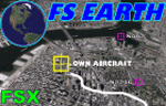
This program acts as a link between Flight Simulator X and Google Earth, letting to follow a flight in real time, over the satellite images generated by Google Earth. Flights can be saved, and many options are available for fine tuning the performance, as well as the map's style (zoom, tilt, orientation). Works on a single computer running FSX and Google Earth all together or, for best experience, can be used on two networked computers running respectively FSX (master) and Google Earth (slave). AI and Multiplayer traffic is also displayed in Google Earth, with course prediction and other information. Requires Flight Simulator X and Google Earth. The program running in trial mode works only around Anchorage, Alaska, (PANC / ANC) for a maximum of five minutes per flight session. Version 5.2 has new aircraft icons & labels and improves the compatibility with Windows Vista. A version for FS2004 is available also.
| Filename: | FS_Earth_52_for_Google_Earth_and_FSX.zip |
| License: | Shareware, time limited |
| Added: | 3rd May 2010, 07:38:23 |
| Downloads: | 2,701 |
| Author: | Luciano Napolitano |
| Size: | 3.46 MB |
© 2001-2026 AVSIM Online
All Rights Reserved
Privacy Policy |