
Where Flight Simulation Enthusiasts Gather from Around the World!
AVSIM Library - Search Results

| Category: Flight Simulator X - Aircraft Repaints, Textures and Modifications | |
| De Havilland Canada DHC-2 Beaver (VH-EAS) |

|
Images related to this file:
File Description:
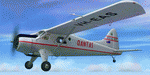
This folder contains a repaint for the Milviz DHC-2 Beaver, representing the first of four Beaver ordered by Qantas, #643 was registered as VH-EAS in 1955 and was used in Papua New Guinea. It was sold to Aerial Agriculture in 1958, becoming VH-AAP, but was written off after an accicent in August 1958. Repaint by Jan Kees Blom, based on th Milviz paintkit.
| Filename: | De_Havilland_Canada_DHC2_Beaver_VHEAS.zip |
| License: | Freeware |
| Added: | 8th August 2018, 10:50:31 |
| Downloads: | 185 |
| Author: | Jan Kees Blom |
| Size: | 9.11 MB |
| Category: Flight Simulator 2004 - Scenery | |
| Fort Resolution CYFR in the Northwest Territories, Canada |
|
Images related to this file:
File Description:
Fort Resolution is on the south side of Great Slave Lake, 75 miles east of Hay River and just west of where the Slave River flows into the lake from Fort Smith. Fort Resolution, the oldest community in the Territories and once a vital link in the fur trade business, is a small town with a population of around 500. It was not included in the original FS9 or Ultimate Terrain so I have added it here.
The airfield is next to the town on the lakeshore. The runway is 4,000 feet of gravel with a displaced threshold at the southern (town) end; it is lit and there is PAPI. There are no scheduled flights to Fort Resolution, just occasional charters; the AI includes a stock FS9 Cessna and a Wasaya Airways PC12.
| Filename: | Fort_Resolution_CYFR_in_the_Northwest_Territories_.zip |
| License: | Freeware, limited distribution |
| Added: | 4th October 2013, 22:11:26 |
| Downloads: | 294 |
| Author: | Roger Wensley |
| Size: | 2.31 MB |
| Category: Flight Simulator 2004 - Scenery | |
| Fort St James CYJM in British Columbia Canada |
|
Images related to this file:
File Description:
Fort St James is a small town of around 1,600 folks at the southeastern end of Stuart Lake, at the head of the Stuart River, and around 360 miles north of Vancouver and 220 miles inland from the coast. It was a long-established trading post for furs, with a permanent presence there from 1806 onwards. The airfield is 3 miles south of the town and is called "Fort St James (Perison)" in the Nav Canada listings. I presume that this is part of their trend towards calling airfields by their location rather than by their name. Makes sense as it is difficult to find information by searching for an airfield that is listed under a name you don't know. The field has an asphalt runway of 4,000 feet aligned 10-28 and at 2,364 feet ASL. There is no lighting. The main user of the airfield is Interior Helicopters Ltd. who are based there as operators, and at Williams Lake as helicopter dealers. For the AI helicopters, there is a screenshot (01) of the AS350 helicopter installation folder when it has been transformed into an AI helicopter. The process is to download and install the Ecuriel AS 350, along with the additional textures, as normal; this is straightforward. Then you download the software shown in screenshot 02 and add it as instructed and as shown in 01 so that the helicopter now operates as AI, with a different air file and a modified config file. I should have included this with the Pemberton post. I have posted this as Fort St James CYJM, but I suggest that you just add it to your previously created "BC airfields" and avoid the inevitable doubling up of common textures etc. Up to you. If you find a defect, email me.
| Filename: | Fort_St_James_CYJM_in_British_Columbia_Canada.zip |
| License: | Freeware, limited distribution |
| Added: | 23rd November 2020, 20:14:04 |
| Downloads: | 150 |
| Author: | Roger Wensley |
| Size: | 2.62 MB |
| Category: Flight Simulator X - Aircraft Repaints, Textures and Modifications | |
| De Havilland Canada DHC-2 Beaver (VH-EAU) |
|
Images related to this file:
File Description:
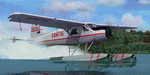
This folder contains a repaint for the Milviz DHC-2 Beaver, representing Beaver c/n 646, one of the first batch of Beavers order by Qantas, being registered VH-EAU in 1955. It went to the Snowy Mountains Hydroelectric Authority as VH-SMB in 1958, being named 'Snow Gander". It went to Aerial Agricultulture in 1967 as VH-SMH and on to Canada in 1972 as C-FTCW. It is still flying with North Pacific Seaplanes Ltd in British Columbia.
| Filename: | De_Havilland_Canada_DHC2_Beaver_VHEAU.zip |
| License: | Freeware |
| Added: | 8th August 2018, 10:48:58 |
| Downloads: | 158 |
| Author: | Jan Kees Blom |
| Size: | 8.62 MB |
| Category: Flight Simulator 2004 - Scenery | |
| Tsuniah Lake Lodge CAF4 in British Columbia Canada |
|
Images related to this file:
File Description:
Tsuniah Lake Lodge is an airstrip that serves the Lodge of the same name at the western end of the lake. Tsuniah Lake is close to the eastern side of Chilko Lake, some 7 miles south of the northern end of Chilko Lake and the recent post of Tsylos Lodge. Tsuniah Lodge is at the eastern and lake end of the grass runway, which is 4,000 feet of grass aligned 04-22 and in good condition at 4,026 feet ASL. No lights. The lodge is extensive with numerous separate cabins and I would expect the prices to be up there with the cost of the chartered planes that delivered guests. There is a second airstrip included here, around 3 miles north of the northern end of Chilko Lake and which used to serve the Wilderness Ranch before it was closed. The runway closed I mean. It is still visible but now not used at all although the ranch still functions. I have posted this as Tsuniah Lake Lodge CAF4, but I suggest that you add this to your "BC airfields" folder as previously suggested. Up to you. If you find a defect, email me.
| Filename: | Tsuniah_Lake_Lodge_CAF4_in_British_Columbia_Canada.zip |
| License: | Freeware, limited distribution |
| Added: | 23rd November 2020, 20:03:34 |
| Downloads: | 86 |
| Author: | Roger Wensley |
| Size: | 10.29 MB |
| Category: Flight Simulator 2004 - Scenery | |
| Schefferville CYKL & Squaw Lake CSZ9 in Quebec Canada |
|
Images related to this file:
File Description:
Schefferville is a town in an area of Quebec that is surrounded by Labrador, the border taking an unusual wriggly course instead of the normal Canadian straight line. One has to presume that there was a lot of political negotiation involved. Take a look at Google Earth to see what I mean. The town was established in 1954 (initially at a site a bit north of the present location, and with a different name) to support newly established iron ore mining. To assist with the exploration for further iron ore and the construction of the railway it seems that there was a forced relocation of native population. Although iron ore mining around Schefferville in its current location flourished through the late 1960's these relocated folk were neglected and suffered "destitute poverty". Through the 1970's iron ore mining declined and ceased in Schefferville in 1982, when most of the 4,000 or so non-native residents left. Since the year 2000 there have been moves to reopen mining in the area and production restarted in 2011, the approximate date of this scenery. The main reason why iron ore mining started again in Schefferville as opposed to any other area in Quebec or Labrador is the existing railway, used for ore transportation. There is no road connection and the airport is the only other means of access for the 250(?) town inhabitants. This population figure is somewhat of a guess, and the town inhabitants are largely company officers who change and move in and out as required by their work. Schefferville airport is to the east of the town. It has a single lit asphalt runway that is aligned 18-36 and is 4,975 feet long and 150 feet wide, with PAPI at both ends. Air Inuit flights connect with Kuujjuaq to the north and Sept-Isles to the south with onward connections to all parts of Canada. There are other charter flights for company personnel. The terminal building has been renovated and the photos show just how dilapidated it had become before this was done. I like it. This scenery also includes Squaw Lake, a float base that is used by Air Saguenay. Or was, as the company was closed in 2019 after an accident involving several deaths. The reason for Air Saguenay establishing a float base here was, once again, the railway, which allowed people to reach Schefferville for a reasonable cost. They could then use the float planes for a shorter distance and reasonable price to reach fishing lodges on the lakes to the north. If you find an error email me please, and note that my email address has been changed to rogwens at Gmail dot com.
| Filename: | Schefferville_CYKL__Squaw_Lake_CSZ9_in_Quebec_Cana.zip |
| License: | Freeware, limited distribution |
| Added: | 1st August 2021, 16:10:32 |
| Downloads: | 126 |
| Author: | Roger Wensley |
| Size: | 16.63 MB |
| Category: Flight Simulator 2004 - Scenery | |
| Sioux Lookout CYXL in northern Ontario, Canada, updated |
|
Images related to this file:
File Description:
This greatly modifies my previous post of Sioux Lookout; it is stand-alone and does not require you to have the 2009 version. The AI provided with the post complements what was included with Dryden (March 2013). Sioux Lookout is in northern Ontario, 40 miles east of Dryden, and 145 miles northwest of Thunder Bay. The town is on the northeastern shore of a lake that I don't know the name of (I've been there, but has anyone COUNTED how many lakes Canada has?). It has a population of around 5,000. The main businesses are lumber, tourism, and health care. The airport is immediately adjacent to the northeastern corner of the town, and has 5,300' of asphalt which is aligned 16-34. There are two taxiways which curve and climb up to the apron which is 20 or 30 feet higher. When you taxi on them the knowledge that in reality you would be climbing makes sense of the curved routing. The apron is large and a mixture of asphalt and gravel. I did not make the terminal building and I have no photo or even a recollection of what it looks like, so you should first install Northwest Ontario Airports by Eric O'Link as he has a terminal building for CYXL that might be how it looks; some of his airfields collide with other and newer versions and I have kept only his CYXL and CYPL bgl's.
| Filename: | Sioux_Lookout_CYXL_in_northern_Ontario_Canada_upda.zip |
| License: | Freeware, limited distribution |
| Added: | 19th March 2013, 19:23:24 |
| Downloads: | 405 |
| Author: | Roger Wensley |
| Size: | 5.08 MB |
| Category: Flight Simulator 2004 - Scenery | |
| Obre Lake CKV4 in the Northwest Territories Canada |
|
Images related to this file:
File Description:
This is a fifth airfield around or linked to Lake Athabasca, in Alberta and Saskatchewan. Obre Lake is some 120 miles northeast of Stony Rapids and is in the Northwest Territories, and the airfield is owned and run by North Of 60 Fishing Camps, which explains it all. It is one of several fishing vacation spots that are serviced by flights from Stony Rapids, and it is these flights to the north that explain the number of regular scheduled flights into Stony Rapids from the south. The Obre Lake camp has docks for boats and also for clients that want to arrive in their own float planes.
| Filename: | Obre_Lake_CKV4_in_the_Northwest_Territories_Canada.zip |
| License: | Freeware, limited distribution |
| Added: | 9th August 2018, 11:36:15 |
| Downloads: | 95 |
| Author: | Roger Wensley |
| Size: | 2.18 MB |
| Category: Flight Simulator 2004 - Scenery | |
| Fort Smith CYSM in Northwest Territories, Canada Revised |
|
Images related to this file:
File Description:
This is an updated version to remove an incomplete static Beaver reported by Graeme (thanks Cobber) and to include other modifications that I made for my own version since posting the original; different taxiway lights, revised aprons, and in particular the revised AI that I mentioned in the original 2011 post. This is complete and can be installed as-is, or used to modify an existing post by changing the original folder contents. Fort Smith is just north of the border between Alberta and Northwestern Territories, midway between Lake Athabasca to the southeast and Great Slave Lake to the north west. You might stop there when flying between Yellowknife or Hay River to La Ronge or Saskatoon. It looks as if it is ex-military and these are the remains of what were once 10,000 feet of asphalt runways. The main runway is now 11/29 and 6,000 feet long, and the secondary one is 1,800 feet of mostly gravel. There is an airline based at the field, Northwestern Air, and fuel is available at a self service point. The town of Fort Smith is two miles east of the airfield, on the bank of the Slave River and where there are some rapids that require a portage to get around them. Before aviation came along the river was a major route to the north and all those furry animals, which was why the Hudson's Bay Company established an outpost there in 1872. Today it has a population of 2,400 and the main activities are government administration of much of the Northwest Territories, education, and tourism.
| Filename: | Fort_Smith_CYSM_in_Northwest_Territories_Canada_Re.zip |
| License: | Freeware, limited distribution |
| Added: | 23rd January 2019, 19:14:44 |
| Downloads: | 143 |
| Author: | Roger Wensley |
| Size: | 7.16 MB |
| Category: Flight Simulator 2004 - Scenery | |
| Fort Liard CYJF in the Northwest Territories, Canada |
|
Images related to this file:
File Description:
Fort Liard is the seventh in a series of airfields that follow (approximately) the Mackenzie River. At the far northern end of the river there is Tuktoyaktuk, then Inuvik, Fort McPherson, Fort Good Hope, Deline, Wrigley, and then Fort Simpson Island and Fort Simpson, all posted. Fort Liard is at 708 feet asl and on the east bank of the the Liard River, around 130 miles south of Fort Simpson where the Liard and Mackenzie join, and about 25 miles from the borders with both British Columbia and the Yukon. The town has a population of about 560 folks.
The airport is next to the town, and has almost 3,000 feet of gravel runway. I have no information regarding when it was built but it may be from the WW2 time; the cleared and grassed area is long enough for a runway 0f 6,000 feet. There are no scheduled flights but North Cariboo Air have a base at the airport for local charters to support survey teams etc. and are almost an on-demand-scheduled airline. I have also added a Buffalo DC3 and GA. There is fuel available, but only by prior arrangement with North Cariboo. Right hand circuits for runway 20.
| Filename: | Fort_Liard_CYJF_in_the_Northwest_Territories_Canad.zip |
| License: | Freeware, limited distribution |
| Added: | 11th July 2014, 13:38:49 |
| Downloads: | 301 |
| Author: | Roger Wensley |
| Size: | 10.07 MB |
© 2001-2026 AVSIM Online
All Rights Reserved
Privacy Policy |