
Where Flight Simulation Enthusiasts Gather from Around the World!
AVSIM Library - Search Results

| Category: Flight Simulator 2004 - Scenery | |
| Kugluktuk CYCO in Nunavut, Canada |

|
Images related to this file:
File Description:
Kugluktuk is on the coast of northern mainland Canada on the mouth of the Coppermine River. It is around 250 miles west of Cambridge Bay and 200 miles south of Ulukhaktok. Tuktoyaktuk is 450 miles west. Kugluktuk used to be called Coppermine as copper was mined along the banks of the river and used for spear and arrow heads, and this attracted a semi-permanent population. The population now numbers around 1,450. The airfield is inland from the village and the 5,500 feet of 100 feet wide gravel runway is aligned 121T/3301T where T stands for "true" as opposed to magnetic in the Northern Domestic Airspace. Both JETA-1 and 100LL are available, dispensed by a truck as the storage tanks are just off the northern edge of the field. There are flights by First Air and Canadian North and the AI includes a daily flight of each, plus a cargo visit by Buffalo; the closest large city is Yellowknife, 375 miles south. I should have mentioned a long time ago that to see the apron lights working requires you to have the "lights_ss_v2" by Sidney Schwartz installed.
| Filename: | Kugluktuk_CYCO_in_Nunavut_Canada.zip |
| License: | Freeware |
| Added: | 10th November 2012, 04:03:35 |
| Downloads: | 428 |
| Author: | Roger Wensley |
| Size: | 3.04 MB |
| Category: Flight Simulator 2004 - Scenery | |
| Maniwaki CYMW in Ontario Canada |
|
Images related to this file:
File Description:
Maniwaki airfield is seven miles south of the town of Maniwaki and some 60 miles north of Ottawa, up the Gatineau River. There is a generous 5,000 feet of runway 03/21 that is 150 feet wide and in bad condition, so bad that there are now almost no markings of any sort (even a centre line, the apron has more paint than the runway!) and the whole lot is going to be redone next summer. The apron is large, and in the summer accomodates two Bombardier CL 415 fire fighting amphibians, which is why there is a large access platform loitering on the apron. There are only five hangars on the field with another one tucked into the trees behind a house. The hangars and the office/cafe building have been modelled specifically for this field. There are further buildings to the north which are not actually on the airfield and which house fire department personnel.
| Filename: | Maniwaki_CYMW_in_Ontario_Canada.zip |
| License: | Freeware, limited distribution |
| Added: | 14th February 2010, 23:12:27 |
| Downloads: | 505 |
| Author: | Roger Wensley |
| Size: | 4.56 MB |
| Category: Flight Simulator 2004 - Scenery | |
| Kangirsuk CYAS in Quebec Canada |
|
Images related to this file:
File Description:
Kangirsuk is an Inuit village in northern Quebec, on the coast of Ungava Bay. The airport is the only means of access on this coast for the population of around 550, apart from a period in late summer. It is between Quaqtaq and Aupaluk, and around 140 miles north of Kuujjuaq, a major centre in this area for supplies, medical care, education, and anything to do with local government. This version of the airport and village is from around 2010, with the original terminal building that has now been replaced. The runway is just under 3,500 feet of lit gravel aligned 04-22 and the AI includes the daily Air Inuit flight that connects Kangirsuk with Kuujjuaq and other local airfields en route. This is almost certainly the last of the northern Quebec coastal airfields that I will be able to model with the correct buildings; only two missing so not too bad.
| Filename: | Kangirsuk_CYAS_in_Quebec_Canada.zip |
| License: | Freeware, limited distribution |
| Added: | 27th August 2020, 17:41:07 |
| Downloads: | 84 |
| Author: | Roger Wensley |
| Size: | 5.67 MB |
| Category: Flight Simulator 2004 - Scenery | |
| CWCY - Cape Young - Nunavut, Canada |
|
Images related to this file:
File Description:
Cape Young was a DEW line station on the nothern mainland coast 50 miles northwest of Kugluktuk, and 50 miles west of Lady Franklin Point. It closed in August 1993. Most of the buildings are still there, in various shades of decay. The runway is also still there and close to 5,000 feet of gravel in length, aligned and signed 110T/290T, though on the atc it will be called 07/25 as FS9 knows nothing about the Canadian Northern Domestic Airspace. There is no runway lighting, and don't be surprised if there are bushes growing amid the gravel.
| Filename: | CWCY__Cape_Young__Nunavut_Canada.zip |
| License: | Freeware, limited distribution |
| Added: | 11th November 2012, 01:23:51 |
| Downloads: | 223 |
| Author: | Roger Wensley |
| Size: | 1.53 MB |
| Category: Flight Simulator 2004 - Scenery | |
| Elko Field B C Canada |
|
File Description:
This scenery is located in B.C. Canada.
Airport name,
1.Elko Field(CBE2) default enhanced. 3000' grass
Aircraft involved: Dc3. call sign,58 kilo lima and the piper 180 call sign, 18 foxtrot lima Doing touch and go's start time 22:00 GMT.
| Filename: | Elko_Field_B_C_Canada.zip |
| License: | Freeware |
| Added: | 15th February 2004, 23:35:15 |
| Downloads: | 1,652 |
| Author: | Frank Betts |
| Size: | 1.63 MB |
| Category: Flight Simulator X - AI Aircraft | |
| Air Canada Boeing 747-200 |
|
Images related to this file:
File Description:
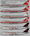
Air Canada Boeing 747-200 for retro AI traffic, with 6 variants, utlizing the FAIB 747-100 model set. This package is for FSX/P3D only with DDS DXT5 textures. Aircraft model and master paint kit by Erez Weber, repaints by Michael Pearson.
| Filename: | Air_Canada_Boeing_747200.zip |
| License: | Freeware |
| Added: | 8th October 2019, 20:10:18 |
| Downloads: | 418 |
| Author: | Michael Pearson |
| Size: | 6.42 MB |
| Category: Flight Simulator X - Scenery | |
| CYDA - Dawson Airport - Yukon, Canada |
|
Images related to this file:
File Description:
FSX Scenery - Dawson City Airport (IATA: YDA, ICAO: CYDA) is located 8 nautical miles (15 km; 9.2 mi) east of Dawson City, Yukon, Canada, in the Klondike River valley, and is operated by the Yukon government. It has a terminal building and like most airports in its class, the runway is not paved. The gravel runway is 5,006 ft (1,526 m) long and at an elevation of 1,215 ft (370 m). A number of studies have recommended moving the airport or realigning the runway as it is in a narrow mountain valley. The airport is classified as an airport of entry by Nav Canada and is staffed by the Canada Border Services Agency (CBSA). CBSA officers at this airport can normally handle aircraft with up to 15 passengers, but are equipped to handle daily Boeing 737 charters between Dawson City and Fairbanks (Fairbanks International Airport) during the peak summer tourism season. For your flying pleasure by John B. Loney, Jr.
| Filename: | CYDA__Dawson_Airport__Yukon_Canada.zip |
| License: | Freeware, limited distribution |
| Added: | 7th April 2016, 17:20:42 |
| Downloads: | 901 |
| Author: | John B. Loney, Jr. |
| Size: | 13.92 MB |
| Category: Flight Simulator 2004 - Scenery | |
| Anticosti Island in Quebec Canada |
|
Images related to this file:
File Description:
Anticosti Island is in the Gulf of St Lawrence, around 25 miles off the Quebec mainland coast. It is some 40 miles wide and 130 miles long on an east west axis. There are few urban areas and only one that can be described as a small town, namely Port Menier at the western end of the southern coast, with a population of under 1,000. There is a ferry service to the harbour.
The airport, Port Menier CYPN, is around 3 miles northeast of the town, with an asphalt runway aligned 11-28, 4,875 feet long and 150 feet wide with PAPI at each end. In 2010 (the approximate date of this scenery) a gravel runway was still visible at the eastern end of the field. This was no longer in use by 2010, except perhaps by small planes on skis in the winter.
The island, with its small population, small urban area, and no industry other than logging, has as a result a mainly undisturbed wildlife population. This has made deer hunting and fishing the main tourist activities, with one company (called Safari) having an exclusive licence to exploit large areas of mountains and rivers. Planeloads of hunters and fishermen are flown in on chartered Nolinor Aviation planes, landing at CYPN. There are a further two airfields in the eastern end of the island, and in 2010 Rivere-Aux-Saumons CTH7 had a 5,500 feet gravel runway, linked by road to a lodge area at the mouth of the river. This is the only lodge area that I have been able to locate, but there are others. To the south Riviere Bell CRB5 had at that time a gravel runway that was 3,000 feet long. This has been lengthened since then and both runways were recently (2021) asphalted.
If you find an error email me please, and note that my email address has been changed to rogwens at Gmail dot com. The reason I am posting this now is that I discovered that my original post ended up in MSFS Original Aircraft instead of in FS2004 Scenery. Ooops!
| Filename: | Anticosti_Island_in_Quebec_Canada.zip |
| License: | Freeware, limited distribution |
| Added: | 28th January 2022, 17:39:46 |
| Downloads: | 121 |
| Author: | Roger Wensley |
| Size: | 11.78 MB |
| Category: Flight Simulator 2004 - Scenery | |
| Inukjuak CYPH - Northern Quebec, Canada |
|
Images related to this file:
File Description:
Inukjuak is a fairly large village on the east coast of Hudson Bay, in Quebec, around 115 miles south of Puvirnituq. The usual Hudson Bay Company post was established there in 1920, and with the opening of a school in 1951 the population grew as the nomadic way of life faded away; the population is now around 1350. Some of the population was forcibly relocated to Resolute and Grise Fiord in 1953 as "human flagpoles", a shameful act by the Canadian government that is hard to believe could ever happen. The airfield is a mile inland from the village and the 3,520 feet of gravel runway is aligned 07/25, and these are magnetic bearings as Inukjuak is not in the Northern Domestic Airspace zone. Both JETA-1 and 100LL fuel is available, though there may be only a limited quantity of 100LL, and probably in drums. The visiting AI airline is Air Inuit.
| Filename: | Inukjuak_CYPH__Northern_Quebec_Canada.zip |
| License: | Freeware, limited distribution |
| Added: | 12th December 2011, 14:44:32 |
| Downloads: | 539 |
| Author: | Roger Wensley |
| Size: | 1.81 MB |
| Category: Flight Simulator 2004 - Scenery | |
| Igloolik CYGT in Nunavut Canada |
|
Images related to this file:
File Description:
Igloolik is a village of 1,600 or so inhabitants at N 69 22 W 81 49 on Igloolik Island, off the northeast corner of the Melville Peninsula. It's name means approximately "Place With A House". The village does not feature in FS9 but is included in this scenery with approximately the right shape, as were the series of northern sceneries before this one. The airfield runway is 4,095 feet of gravel 100 feet wide and is at 173 feet above sea level. There is a gradient to it, but unfortunately this cannot be replicated in FS. I added the roads, a new airfield background, plus of course there is the scenery file and the AFCAD and AI, which has two planes visiting, a First Air HS748 and a Canadian North Dash 8-100.
| Filename: | Igloolik_CYGT_in_Nunavut_Canada.zip |
| License: | Freeware, limited distribution |
| Added: | 23rd December 2010, 02:28:26 |
| Downloads: | 522 |
| Author: | Roger Wensley |
| Size: | 2.7 MB |
© 2001-2026 AVSIM Online
All Rights Reserved
Privacy Policy |