
Where Flight Simulation Enthusiasts Gather from Around the World!
AVSIM Library - Search Results

| Category: Flight Simulator 2004 - Scenery | |
| Modesto City-County Airport |

|
File Description:
FS2004 Scenery-Modesto City-County-Harry Sham Field Airport (KMOD) serves Modesto and Stanislaus County and is owned jointly by the City of Modesto and Stanislaus County, and the airport is operated by the City of Modesto. The airport has more than one runway. The longest is a paved runway extending 5911 feet. The facility is at an elevation of 97 feet at a distance of about 2 miles from Modesto. Created with FSDS2, Rwy12, Lago's FSE, AFCAD2 and Traffic Tools. Textures included. By John B. Loney, Jr.
| Filename: | Modesto_CityCounty_Airport.zip |
| License: | Freeware |
| Added: | 29th October 2005, 05:26:38 |
| Downloads: | 1,219 |
| Author: | John B. Loney, Jr. |
| Size: | 1.57 MB |
| Category: Flight Simulator 2004 - Scenery | |
| Elk City Municipal Airport, Ok |
|
File Description:
FS2004 Scenery-Elk City Municipal Airport,Ok (KELK) serves Elk City and Beckham County and is owned by the City Of Elk City. The paved runway extends for 4402 feet. The airport provides servicing of aircraft, aircraft maintenance and hanger facilities. The facility is at an elevation of 2002 feet at a distance of about one mile from Elk City. Scenery has dynamic scenery created with Lago's FSE. Modified AFCAD file. Objects placed using EZ Scenery, Rwy12 and FSDS3. Includes flightplan for AI traffic and textures for FSDS3 segments.
| Filename: | Elk_City_Municipal_Airport_Ok.zip |
| License: | Freeware |
| Added: | 11th February 2006, 23:57:10 |
| Downloads: | 514 |
| Author: | John B. Loney, Jr. |
| Size: | 741.52 KB |
| Category: Flight Simulator 2004 - Scenery | |
| Joe Foss-Sioux Falls Regl KFSD |
|
File Description:
FS2004 Scenery-Joe Foss Field - Sioux Falls Regional Airport (KFSD) serves Sioux Falls and Minnehaha County and is owned by Sioux Falls Regional Airport Authority. The airport has more than one runway. The longest is a paved runway extending 8999 feet. The facility is at an elevation of 1429 feet at a distance of about three miles from Sioux Falls. South Dakota's 114th Fighter Group, nicknamed the Lobos, is stationed at Joe Foss Field, Sioux Falls, SD. Created entirely with EZ Scenery. New AFCAD2 file with AI flight plans. By John B. Loney, Jr.
| Filename: | Joe_FossSioux_Falls_Regl_KFSD.zip |
| License: | Freeware |
| Added: | 17th July 2006, 01:30:18 |
| Downloads: | 2,311 |
| Author: | John B. Loney, Jr. |
| Size: | 1.39 MB |
| Category: Flight Simulator 2004 - Aircraft Repaints, Textures and Modifications | |
| Grumman F-14A Tomcat, VF-33, 'TARBOX 211', Starfighters at War |
|
Images related to this file:
File Description:
This repaint was done to honor all the former personnel of VF-33, The Starfighters, and their families. GONE BUT NOT FORGOTTEN, VF-33 was disestablished in 1993. This repaint represents TARBOX 211, a Tomcat of VF-33 that participated in Operation Desert Storm (1991). On January 19, 1991 Tomcats from VF-33 flew as part of a package that destroyed the critical Latifiya SCUD missle production facility in Iraq. Each VF-33 crewmwmber who participated in the strike was awarded the Navy Commendation Medal with combat distinguishing device. Aircraft and paintkit by IRIS.
| Filename: | Grumman_F14A_Tomcat_VF33_TARBOX_211_Starfighters_a.zip |
| License: | Freeware |
| Added: | 26th November 2009, 01:46:23 |
| Downloads: | 258 |
| Author: | Perry S. Hayes |
| Size: | 4.48 MB |
| Category: Flight Simulator 2004 - AFCAD Files | |
| EGPH - Edinburgh, Scotland |
|
Images related to this file:
File Description:

This is an airport facilities file for the payware add-on EGPH - Edinburgh from UK2000. This ADE file recreates parking and AI flow as close as possible to the real EGPH. You will need the payware scenery from UK2000 to use this file; this is only an ADE file to replace the stock one that comes with that payware. This file was made with ADE9X and should not be opened or edited with any other airport facility editing software like AFX or AFCAD. NOTE: This file is optimized for AI traffic use.
| Filename: | EGPH__Edinburgh_Scotland.zip |
| License: | Freeware |
| Added: | 3rd February 2010, 02:06:06 |
| Downloads: | 738 |
| Author: | Mariano Bonaccorso |
| Size: | 496.19 KB |
| Category: Flight Simulator 2004 - Scenery | |
| Collings and Mansfield |
|
File Description:
FS2004 Scenery - In 1979 the Collings Foundation was founded to support "living history" events involving transportation. Originally founded with the focus of automobiles, the foundation moved to aircraft as the need for quality aviation history exhibits grew. Mansfield Municipal Airport (1B9) serves Mansfield and Bristol County, MA and is owned by the Town Of Mansfield. The airport has more than one runway. The longest is a paved runway extending 3498 feet. The facility is at an elevation of 122 feet. Created using Instant Scenery by John B. Loney, Jr.
| Filename: | Collings_and_Mansfield.zip |
| License: | Freeware, limited distribution |
| Added: | 3rd February 2010, 02:07:34 |
| Downloads: | 247 |
| Author: | John B. Loney, Jr. |
| Size: | 1.78 MB |
| Category: Flight Simulator 2004 - Scenery | |
| Knoxville Municipal KOXV |
|
Images related to this file:
File Description:
FS2004 Scenery - The Knoxville Municipal Airport, (KOXV) renamed Jim Bellamy Field, serves the greater Knoxville community and the surrounding areas of Marion County, Iowa. The airport is comprised of 120 acres, and is located at the southern edge of Knoxville, adjacent to the Highway 14 & Highway 5/92 interchange. The 4,000 foot (by 75 foot) single runway is constructed of concrete, with parallel taxiway. The facility is at an elevation of 928 feet at a distance of about 2 miles from Knoxville. Created for your flying pleasure by John B Loney, Jr.
| Filename: | Knoxville_Municipal_KOXV.zip |
| License: | Freeware, limited distribution |
| Added: | 13th October 2012, 17:16:54 |
| Downloads: | 295 |
| Author: | John B. Loney, Jr. |
| Size: | 29.77 MB |
| Category: Flight Simulator X - Scenery | |
| Knoxville Municipal Airport KOXV |
|
Images related to this file:
File Description:
FSX Scenery - The Knoxville Municipal Airport, (KOXV) renamed Jim Bellamy Field, serves the greater Knoxville community and the surrounding areas of Marion County, Iowa. The airport is comprised of 120 acres, and is located at the southern edge of Knoxville, adjacent to the Highway 14 & Highway 5/92 interchange. The 4,000 foot (by 75 foot) single runway is constructed of concrete, with parallel taxiway. The facility is at an elevation of 928 feet at a distance of about 2 miles from Knoxville. Created for your flying pleasure by John B Loney, Jr.
| Filename: | Knoxville_Municipal_Airport_KOXV.zip |
| License: | Freeware, limited distribution |
| Added: | 13th October 2012, 17:18:20 |
| Downloads: | 541 |
| Author: | John B. Loney, Jr. |
| Size: | 31.45 MB |
| Category: Flight Simulator X - Scenery | |
| Cape Spencer Lihthouse |
|
Images related to this file:
File Description:
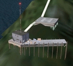
A small scenery which adds the Cape Spencer Lighthouse facility operated and maintained by the US Coast Gaurd. It is 80 nm west of Jeneau, Alaska with an NDB @ 322.0, a landable helipad and many objects. There was no actual land at the actual coordinates so I used rocks in three different sizes from the default FSX object library to create as best I could the rocks which the lighthouse is built on. It is small but adds something to this bare area and adds something to your flying adventures. By savageagle. Enjoy.
| Filename: | Cape_Spencer_Lihthouse.zip |
| License: | Freeware |
| Added: | 28th October 2012, 12:59:54 |
| Downloads: | 572 |
| Author: | Tim Durham |
| Size: | 1.35 MB |
| Category: Flight Simulator 2004 - Scenery | |
| LESU - Pirineus-la Seu d'Urgel - Catalan, Spain |
|
File Description:
La Seu d'Urgell airport, officially Pirineus - la Seu d'Urgel airport and also known as Pirineus-Andorra airport is an airport facility owned by the Government of Catalonia and hosts general aviation and emergency flights. It will be the main hub for Air Andorra, airline which starts serving Andorra on 8 January 2015. It is located in the comarca of Alt Urgell, south of la Seu d'Urgell (Spain) and 12 km south of Andorra, in the mountain of Ensiula between the towns of Montferrer i Castellbo and Ribera d'Urgellet.
| Filename: | LESU__Pirineusla_Seu_dUrgel___Catalan_Spain.zip |
| License: | Freeware |
| Added: | 10th December 2014, 11:58:34 |
| Downloads: | 637 |
| Author: | Billy Guo |
| Size: | 722.03 KB |


© 2001-2026 AVSIM Online
All Rights Reserved
Privacy Policy |