
Where Flight Simulation Enthusiasts Gather from Around the World!
AVSIM Library - Search Results

| Category: Flight Simulator X - Utilities | |
| MH's AI Traffic Pack V1.0 |

|
File Description:
This package consists of four programs, one of them my previously published AI Traffic Check, now as version 2.0, and three new utility programs. AI Traffic Check has been improved to give more detailed information on traffic BGL files (including boat traffic) and aircraft configuration.
AI Traffic Modifier can be used to modify aircraft configuration files of FS to update them to FSX standards. AI Traffic To FSX Converter converts AI traffic files of flight simulator from old format (FS9) to new format (FSX). The last one, AI Traffic Merger will find and re-install lost texture files of AI aircraft and at the same time new AI aircraft can be installed from a given source folder.
| Filename: | MHs_AI_Traffic_Pack_V10.zip |
| License: | Freeware, limited distribution |
| Added: | 19th December 2007, 21:34:09 |
| Downloads: | 3,080 |
| Author: | Michael Heise |
| Size: | 992.44 KB |
| Category: Flight Simulator 2004 - Aircraft Repaints, Textures and Modifications | |
| AS Ecureuil 350 "RAN" |
|
Images related to this file:
File Description:
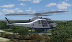
This is a repaint of the great Peter and Tamas Nemeth AS Ecureuil 350 Helicopter. This is a complete aircraft so no other files are required to install and or to fly the aircraft. The file contains two (2) sets of textures of the two RAN Ecureuil varients. They have both been well tested in FS9 ONLY. I cannot say if they will work in FSX. If you choose to try them in FSX then you do so at your own risk (so to speak). Installation, Distribution Limitations and my email can be found in the ReadMe2 File, while information regarding the original aircraft producers can be found in the ReadMe file.
| Filename: | AS_Ecureuil_350_RAN.zip |
| License: | Freeware, limited distribution |
| Added: | 5th October 2010, 08:29:28 |
| Downloads: | 267 |
| Author: | Tony Cannon, Tams and Peter Nemeth |
| Size: | 21.14 MB |
| Category: Flight Simulator 2004 - Scenery | |
| Dawson Creek CYDQ in British Columbia, Canada UPDATED |
|
Images related to this file:
File Description:
This is a revised version of Dawson Creek CYDQ and the floats base CBD3, made primarily to provide one of the parked planes with it's textures but also to improve the apron markings and the AI. The float AI now includes Beavers and I also removed two planes that were not properly showing their textures in my current FS9 installation. The Beavers were included in my post of Nimpo Lake CAF8 and will need to be installed to show up here. This version is complete in itself and can be installed as-is if you do not have the original scenery. Dawson Creek is at 2,148 feet asl just east of the Rocky Mountains, less than 10 miles west of the BC/Alberta border and where the Rockies are at their narrowest. The population grew when the Northern Alberta Railway was extended to Dawsons Creek in 1932, and grew even more more when the Alaska Highway was built in 1942, starting from Dawsons Creek. In the 1950's the town was linked through the Rockies by a railway and a road to the BC interior, and the town grew again. Now it is static at just under 12,000 and once again has become a farming centre, with Fort St John and Grand Prairie winning out for new industry and commerce. The airport is just to the east of the town. The runway is 5,000 feet of wide asphalt (150 feet) aligned 06/24, lit, and with PAPI and approach lights. There is also a water runway for float planes, separately designated as Dawson Creek CBD3. The two effectively operate as one; traffic for both use the mandatory frequency of 122.2 and talk to one controller in one control tower. However, in FS9 the ATC for two separately designated airfields (or float fields) operates as if they are nowhere near each other and takes no notice of near misses between the two lots of planes. As a result I have put them both in un-manned tower mode so you will announce your position and intentions and select your own parking spots, either next to one of the hangars or on the grass. The aprons vary from asphalt, to concrete, onwards to gravel, and then further onwards to some gravel amid the bare dirt; I have replicated this variation as far as FS9 permits.
| Filename: | Dawson_Creek_CYDQ_in_British_Columbia_Canada_UPDAT.zip |
| License: | Freeware, limited distribution |
| Added: | 17th December 2018, 17:50:08 |
| Downloads: | 205 |
| Author: | Roger Wensley |
| Size: | 26.71 MB |
| Category: Flight Simulator 2004 - Scenery | |
| Nome PAOM on the northwestern coast of Alaska |
|
Images related to this file:
File Description:
There are four main northwestern Alaska towns which have good airports and are serviced by Alaska Airlines. From these airports local flights connect to nearby villages, "nearby" in Alaska meaning up to 200 miles away. The northernmost is Barrow. Southwest of Barrow is Kotzebue, then Nome, and the furthest south is Bethel. The town of Nome is south of the Bering Strait on the southern coast of the Seward Peninsula, around 185 miles south of Kotzebue, with a population of about 3,800. It is the town that led to the creation of the most famous dogsledge race in the world, the Iditarod, which is based on the delivery to Nome of diphtheria serum during the blizzard conditions of the winter of 1925. The Nome airport (it currently has no other name) was originally built as the last of the refuelling airfields for planes being ferried to Russia during WW2. It has two runways, aligned 09-27 and 02-20 in FS9 (the wandering magnetic north has recently renamed the magnetic headings) and both of them around 6,000 feet with an ILS on 27. There is a modern airport layout diagram included showing taxiway names etc. Alaska Airlines, ERA, and Bering Air (which is headquartered in Nome), along with the shared cargo terminal for Northern Air Cargo and Everts Air, are all on the southern apron. The northern apron is mainly for GA, along with maintenance facilities, a garage building that also houses a weather bureau, and at the far northern end of runway 02-20 an apron and hanger for the Alaska Air National Guard. All AI aircraft in FS9 much prefer to use a runway that has an ILS and so will continue to use 09-27 even if the wind is from the north or south, right up until it reaches 30+ knots, so for AI realism in FS9 a permanent wind from the west would be the most realistic on a daily basis. There is also a small gravel strip just north of the town and this is included (94Z), as are some old line-of-sight radio communication reflectors on the hills above the town. There is a note about making adjustments to Ultimate Terrain Alaska-Canada regarding both realistic road lighting and also auto-generation.
| Filename: | Nome_PAOM_on_the_northwestern_coast_of_Alaska.zip |
| License: | Freeware, limited distribution |
| Added: | 18th October 2016, 02:38:42 |
| Downloads: | 487 |
| Author: | Roger Wensley |
| Size: | 22.65 MB |
| Category: Flight Simulator 2004 - Scenery | |
| PABR - Barrow - Alaska, USA |
|
Images related to this file:
File Description:
The town of Barrow is in the far north of Alaska, and is best known in flying circles as the place where Wiley Post crashed his floatplane on takeoff and killed himself and Will Rogers. The crash was some 15 miles south of Barrow and was "assisted" by the mismatched fuselage, wings, and floats that had been assembled to create the floatplane. The Barrow population is largely Inupiat and totals some 4,400. The downtown area of Barrow is immediately north of the airport. The second and largest part of Barrow is further north past a string of lagoons and is locally called Browerville. To the northeast along the coast is the smallest part around what used to be the Naval Arctic Research Lab, and is now a college. To the east of this are the DEW buildings, plus two large navy hangars and the gravel runway that was used to serve the DEW station. The PABR runway is aligned 06-24 in FS9 and is 7,100 feet long and 150 feet wide, built on top of a gravel base and surround that copes with the underlying permafrost. There is PAPI at both ends and an ILS and approach lights on 06; 06 circuits are to the right. The airport notes include a warning that the apron is not a standard width and that large planes that are enroute to the far end of the runway will not be able to taxi past a plane parked at the gate and should use the runway as a taxiway, then turn and takeoff. FS9 AI cannot cope with that, so the apron here is wider. There are, in real life and the AI, daily flights by Air Alaska (three at least) and Era (several, and which is now called Ravn, hence the new hangar door motif) and air cargo flights by Northern Air Cargo and Everts, plus GA. The buildings have been made with photographic textures or textures made from reference photos. I decided that while 500+ scenery objects was probably ok for most people the required 900+ to "make" the town of Barrow would likely not be. The auto-generated FS9 town objects could not be left as Barrow with trees would not look at all like reality; I have "faded" the density of the town buildings into the distance from the airport.
| Filename: | PABR__Barrow__Alaska_USA.zip |
| License: | Freeware, limited distribution |
| Added: | 17th May 2016, 09:32:36 |
| Downloads: | 972 |
| Author: | Roger Wensley |
| Size: | 15.12 MB |
| Category: Flight Simulator 2004 - Scenery | |
| Dixie A05 Forest Service airfield in Idaho USA |
|
Images related to this file:
File Description:
This airfield is in the mountains of Idaho, the first in a series. There are not many mountain airfields that can be succesfully modelled in FS9 because the FS9 terrain does not always match reality; no creek for instance, or the valley too small. There are others where the grass strip is all there is, so there is nothing to model apart from resizing the cleared area. Some are well known, well maintained, have clean shower facilities, and are well used for a weekend by small planes with two people and a tent on board, for instance Johnson Creek. Others are less well known but still in good condition, such as Dixie or Big Creek. And there are also some with cabin rental facilities, such as Sulphur Creek Ranch. Other names come to mind, such as Flying B and Pistol Creek, but unfortunately for one reason or another these could not be made. The other difficulty involving hills is succesful AI landings and take offs. At Johnson Creek, for instance, the wind should be from the south to make AI landings more likely to succeed. Dixie is south of the village of the same name, and not to be confused with the dirt strip that is just beside the village. The runway is at 5,148 feet ASL, just over 4,000 feet long and aligned 18-36, and the parking area is at the northern end, opposite the Forest Service buildings. There is a chart of the area included, and to the south of Dixie is the next in the series, Big Creek U60.
| Filename: | Dixie_A05_Forest_Service_airfield_in_Idaho_USA.zip |
| License: | Freeware, limited distribution |
| Added: | 25th May 2017, 17:53:48 |
| Downloads: | 153 |
| Author: | Roger Wensley |
| Size: | 8.69 MB |
| Category: Flight Simulator X - Scenery | |
| KAFW Fort Worth Alliance Airport - Texas, US |
|
Images related to this file:
File Description:
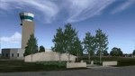
Ft. Worth Alliance Airport opened in 1989 and was billed as the world's first purely industrial airport. It is located around 14 miles North of the central business district of Ft. Worth and is also nearby the Dallas/Ft. Worth International Airport (KDFW). The airport serves general aviation, corporate jet, cargo, and military air traffic on a daily basis and it's proximity to the Texas Motor Speedway (only a few miles) brings extra dense traffic on race weekends. The airport is home to the American Airlines 777 and 767 maintenance base, FedEx Southwest Regional Sort Hub, Bell-Helicopter Training Center, DEA Air Operations Center and DynCorp International. Sadly the American Airlines maintenance base is set to close at the end of 2012 but is being kept alive in FSX!
This scenery features custom 3d buildings and objects bringing you a very accurate rendition of Ft. Worth Alliance Airport. Requires FSX Acceleration for the all scenery objects to display correctly.
Note: These files MUST be installed for the scenery to work correctly (otherwise there will be missing scenery objects at the airport):
-Filename: fsx_lts.zip - Ramp Lighting for FSX by Jim Dhaenens
-Filename: dlfcorelibraries2fsx.zip - Dan French Core Library Vol. 2
-Filename: lightstoo.zip - Jim Dhaenens Airfield Lighting
-Filename: objlib-jgse-fsx.zip - John Stinstrom JGSE Yellow Objects - this newer file replaces the older FS9 libraries with FSX versions
-Filename: objlib-ggse-fsx.zip - John Stinstrom GGSE Green Objects - this file also replaces FS9 libraries with FSX versions
| Filename: | KAFW_Fort_Worth_Alliance_Airport__Texas_US.zip |
| License: | Freeware, limited distribution |
| Added: | 12th December 2012, 16:56:36 |
| Downloads: | 2,935 |
| Author: | Brandon Thetford |
| Size: | 439.24 MB |
| Category: Flight Simulator 2004 - Scenery | |
| Warrenton, VA - KHWY - Patch fixed |
|
File Description:
The scenery for KHWY is perfectly fine but that included W66 file was screwed it up to my bad. I totally forgot about this uploaded was already too late. I wasn't thinking in my head. My goofed. Sorry for your inconvenience that someone told me figured it out without W66 runs fine no crashed desktop FS9. If you run KHWY with W66 old file was crashed. Sorry about that. I am enclosed patch new W66. It will be not crash again. I wasn't supposed to touch the ARP point out of the field. It is caused by crashed. I don't understand what is system S9 for. LOL! I leave it alone ARP point and complied with ADE. It works fine!
| Filename: | Warrenton_VA__KHWY__Patch_fixed.zip |
| License: | Freeware |
| Added: | 21st June 2020, 21:23:18 |
| Downloads: | 75 |
| Author: | Stuart John Gilbert II |
| Size: | 4.52 KB |
| Category: Flight Simulator 2004 - Aircraft Repaints, Textures and Modifications | |
| Xtra Airways Boeing 737-800 |
|
File Description:
Let me start by saying that Xtra Airways is NOT a fictional airline, it is indeed an actual factual airline that operates 737-400 and 737-800 aircraft. This is the POSKY 737-800 repainted in the scheme of the Xtra Airways. This paint is about 99% photoreal, the tail being just about completely photoreal. Inspiration for this paint came after this guy nearly blew me off the road a few days ago while taking off. These are textures only, you'll need POSKY's 738 WITHOUT winglets to use this paint (I recommend downloading their Delta wavy gravy livery off their website as this model does not have winglets). Only tested in FSX but you should have no problems with it in FS9.
| Filename: | Xtra_Airways_Boeing_737800.zip |
| License: | Freeware |
| Added: | 24th February 2008, 12:56:55 |
| Downloads: | 346 |
| Author: | Josh Gore | POSKY |
| Size: | 4.91 MB |
| Category: Flight Simulator 2004 - Scenery | |
| Burlington-Alamance Regional KBUY |
|
File Description:
This scenery is unique in that it is designed for the student or visiting pilot flying in
and out of this airport. All navaids are as accurate as possible for FS9. Glideslope is scheduled to be activated in October 2003.
(The new 6,000' extension has been delayed and completion date is now 2004). Both are
included. Numerous navaids and aerial photographs were used. Approved for practice but not for
navigation. Check current NOTAMS.
Special thanks to Dan the Airport Manager and Mark the Chief Flight
Instructor. See Dan or Mark for CD copies of this file.
If you are planning on coming to the Piedmont or are a student pilot you will want this! Special readme inside.
-jimmy R martin &
David Fraizer
[email protected].
| Filename: | BurlingtonAlamance_Regional__KBUY.zip |
| License: | Freeware |
| Added: | 4th September 2003, 18:20:47 |
| Downloads: | 1,963 |
| Author: | jimmy R martin & David Fraizer |
| Size: | 3.47 MB |


© 2001-2026 AVSIM Online
All Rights Reserved
Privacy Policy |