
Where Flight Simulation Enthusiasts Gather from Around the World!
AVSIM Library - Search Results

| Category: Flight Simulator 2004 - Scenery | |
| CYDF Deer Lake Regional Airport for Newfoundland & Labrador FS9 |

|
Images related to this file:
File Description:
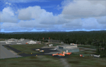
This scenery is a very accurate freeware version of Deer Lake Regional airport and sorounding area, on the west coast of the island of Newfoundland.
Designed to suit a variaty of computers, there is a setup for everyone.
There is something here for Heli, Bush, Low and slow right up to the IFR hight in the sky fliers.
Two solid years went into this scenery to try to capture as much detail as possible.
I really hope you enjoy it as much as Flight Ontario enjoyed working on it.
| Filename: | CYDF_Deer_Lake_Regional_Airport_for_Newfoundland__.zip |
| License: | Freeware |
| Added: | 2nd May 2010, 02:07:39 |
| Downloads: | 1,935 |
| Author: | Al Sibley Flight Ontario |
| Size: | 89.8 MB |
| Category: Flight Simulator X - Scenery | |
| CYQQ (2010) Version 2 for FS9, FSX and Prepar3D |
|
Images related to this file:
File Description:
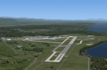
CYQQ (2010) portrays Canadian Forces Base Comox (Vancouver Island, British Columbia, Canada) (CYQQ), the Comox Valley Air Terminal and surrounding area. It is fully compatible with Ultimate Terrain Canada/Alaska for FS2004, Ultimate Terrain X - Canada for FSX and ORBX's FTX NA Blue. CYQQ (2010) includes over 100 "hand-crafted" buildings and other structures and 10 different vintage aircraft on static display, as well as aircraft and traffic files for a realistic AI scenario that causes a variety of military aircraft that come and go. (Use BC Regional AI - also available from this file library - for scheduled traffic.) Civilian AI is now routed so as not to transit military aprons.
Aside from the new approach lighting, generally, this new version is visually identical to its predecessor - even though quite different internally. As well, to the extent possible, it is compatible with Prepar3Dv2.
| Filename: | CYQQ_2010_Version_2_for_FS9_FSX_and_Prepar3D.zip |
| License: | Freeware, limited distribution |
| Added: | 20th June 2014, 11:39:47 |
| Downloads: | 11,034 |
| Author: | Don Grovestine |
| Size: | 33.19 MB |
| Category: Microsoft Flight Simulator (2020) - Aircraft Repaints, Textures and Modifications | |
| Goodyear FG-1D Corsair RNZAF NZ5531 |
|
Images related to this file:
File Description:
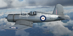
This folder contains a repaint for the FG-1D Corsair by Milviz, in the colors of F4U-1D NZ5531. It was used as a trainer at the RNZAF pilot training facility in Wigram. For some reason it was stripped of its paint and as such, was one of two bare-metal Corsairs with the RNZAF, the other being NZ5526. Repaint by Jan Kees Blom.
| Filename: | Goodyear_FG1D_Corsair_RNZAF_NZ5531.zip |
| License: | Freeware |
| Added: | 24th April 2021, 19:10:12 |
| Downloads: | 25 |
| Author: | Jan Kees Blom |
| Size: | 52.12 MB |
| Category: Flight Simulator X - AFCAD Files | |
| KNOG - Naval Auxiliary Landing Field Orange Grove - Orange Grove, Texas - USA |
|
Images related to this file:
File Description:
NALF Orange Grove is an important support airfield for NAS Kingsville which provides primary jet training (and carrier qualification) for new Navy, Marine, and selected foreign pilots. This is a complete airport rebuild with new runways, new taxiways, ramps, signage, and tower and administration buildings. It features a fire station, POL facility, access roads, new terrain masks, and parking,(including covered parking) for 15 transient aircraft.
| Filename: | KNOG__Naval_Auxiliary_Landing_Field_Orange_Grove__Orange_Grove_Texas__USA.zip |
| License: | Freeware |
| Added: | 4th July 2015, 02:31:38 |
| Downloads: | 340 |
| Author: | Allen Laughmiller |
| Size: | 14.13 KB |
| Category: Flight Simulator 2004 - Scenery | |
| Indianapolis Executive KTYQ |
|
Images related to this file:
File Description:
FS2004 Scenery - Indianapolis Executive Airport (Formally known as Indianapolis Terry Airport) KTYQ, serves Indianapolis and Boone County and is owned by R. Vansickle. The paved runway extends for 5500 feet. The facility is at an elevation of 922 feet at a distance of about 14 miles from Indianapolis. Created with FSDS2, Rwy12 and Lago's FSE. AFCAD2 and Traffic Tools required. By John B. Loney, Jr.
| Filename: | Indianapolis_Executive_KTYQ.zip |
| License: | Freeware, limited distribution |
| Added: | 17th May 2010, 22:30:47 |
| Downloads: | 786 |
| Author: | John B. Loney, Jr. |
| Size: | 984.06 KB |
| Category: Flight Simulator X - AFCAD Files | |
| KIAB - McConnell AFB - Wichita, KS |
|
File Description:
By request, here is an improved version of the stock McConnell AFB including the Boeing manufacturing facility and the Kansas Aviation Museum. I added many Military_Cargo parking spaces. I added the fire station and fire trucks. I removed and replaced some default buildings and added additional buildings. Added static fuel trucks, parking lots with cars and light poles. Added,
removed, or adjusted taxiways and aprons.
| Filename: | KIAB__McConnell_AFB__Wichita_KS.zip |
| License: | Freeware |
| Added: | 31st May 2008, 20:44:30 |
| Downloads: | 1,101 |
| Author: | Jim Cook |
| Size: | 19.21 KB |
| Category: Flight Simulator 2004 - Scenery | |
| Northeast Philadelphia Airport |
|
File Description:
FS2004 Scenery-Northeast Philadelphia Airport (KPNE) serves Philadelphia and Philadelphia County and is owned by the City Of Philadelphia. The airport has more than one runway. The longest is a paved runway extending 7000 feet. The facility is at an elevation of 121 feet at a distance of about 10 miles from Philadelphia.Modular construction using FSDS2, Rwy12, Lago's FSE, Traffic Tools and AFCAD2. Both runways active.
| Filename: | Northeast_Philadelphia_Airport.zip |
| License: | Freeware |
| Added: | 20th November 2005, 07:12:58 |
| Downloads: | 1,483 |
| Author: | John B. Loney, Jr. |
| Size: | 2.27 MB |
| Category: Flight Simulator 2004 - Scenery | |
| Richmond Municipal Airport KRID |
|
Images related to this file:
File Description:
FS2004 Scenery - Richmond Municipal Airport (KRID), Richmond, IN serves Richmond and Wayne County and is owned by Richmond Boac. The airport has more than one runway. The longest is a paved runway extending 5200 feet. The facility is at an elevation of 1140 feet at a distance of about 5 miles from Richmond. Created for your flying pleasure with Instant Scenery 2 by John B. Loney, Jr.
| Filename: | Richmond_Municipal_Airport_KRID.zip |
| License: | Freeware, limited distribution |
| Added: | 3rd August 2010, 22:22:45 |
| Downloads: | 396 |
| Author: | John B. Loney, Jr. |
| Size: | 5.09 MB |
| Category: Flight Simulator 2004 - Scenery | |
| Montauk Airport KMTP |
|
File Description:
FS2004 Scenery-Montauk Airport (KMTP) serves Montauk and Suffolk County and is owned by Montauk Airport Inc. The paved runway extends for 3480 feet. The facility is at an elevation of 20 feet at a distance of about 3 miles from Montauk. Dynamic scenery with Lago's FSE. Modified AFCAD2 file and Traffic Tools required. Created with EZ Scenery. EZ Scenery libraries required. By John B. Loney, Jr.
| Filename: | Montauk_Airport_KMTP.zip |
| License: | Freeware, limited distribution |
| Added: | 11th May 2010, 21:42:38 |
| Downloads: | 875 |
| Author: | John B. Loney, Jr. |
| Size: | 392.4 KB |
| Category: Flight Simulator 2004 - Scenery | |
| Butler Memorial Airport |
|
File Description:
FS2004 Scenery-Butler Memorial Airport (KBUM) serves Butler and Bates County and is owned by the City Of Butler, Mo. The paved runway extends for 4000 feet. The facility is at an elevation of 892 feet at a distance of about 2 miles from Butler. Created with FSDS3, Rwy12, EZ Scenery and Lago's FSE. FSDS3 textures included. Scenery have challenging approach. Read readme file.
| Filename: | Butler_Memorial_Airport.zip |
| License: | Freeware |
| Added: | 23rd January 2006, 04:20:30 |
| Downloads: | 400 |
| Author: | John B. Loney, Jr. |
| Size: | 703.77 KB |
© 2001-2026 AVSIM Online
All Rights Reserved
Privacy Policy |