
Where Flight Simulation Enthusiasts Gather from Around the World!
AVSIM Library - Search Results

| Category: Flight Simulator 2002 - AI Flight Plans | |
| Touch Pekin And Go With ONE Added File |

|
File Description:
Have fun flying circuits at Pekin (C15) with the three default C172 aircraft that came with FS9. All three will be on the ground if you start at C15 and will crank, taxi, hold short, announce takeoff on 122.80, and depart. They announce all position calls correctly and timely. They each do a touch n go in order with proper sequencing and then do it again and again. All that you need do is place the provided "FlightPekin.bgl" in the correct folder and then have fun. No other files are needed. The exterior 172 model is very frame rate friendly and will not impact frame rates significantly even on 1.2 ghz machines. This file is intended for audiences of all ages who have FS9.
| Filename: | Touch_Pekin_And_Go_With_ONE_Added_File.zip |
| License: | Freeware |
| Added: | 8th December 2003, 01:12:22 |
| Downloads: | 169 |
| Author: | Bob Samuelson |
| Size: | 248.13 KB |
| Category: Flight Simulator 2004 - Aircraft Repaints, Textures and Modifications | |
| ATR 72-500 "Air New Zealand" |
|
Images related to this file:
File Description:
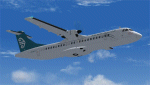
This file contains 2 (two) repaints of the ISDT ATR 72-500 in the Air New Zealand livery for FS9. Both repaints are of Air New Zealand with one being slightly more faded than the other. Same livery, two versions. This is a complete aircraft so no other files are required for installation or to fly her. That being said, the plane does include a default Cessena Panel and sounds (provided by ISDT) so a proper ATR panel and soundset would be highly recommended. One such freeware panel is that made by Panel by Antonio Bucoli. These liveries have been tested in FS9 ONLY without an issue. Installation, Distriobution Limitations and my contact details are included in the various ReadMe files.
| Filename: | ATR_72500_Air_New_Zealand.zip |
| License: | Freeware, limited distribution |
| Added: | 14th October 2010, 00:36:04 |
| Downloads: | 838 |
| Author: | Tony Cannon and ISDT |
| Size: | 14.42 MB |
| Category: Flight Simulator 2004 - Scenery | |
| Cavanaugh Bay 66S Idaho Airport |
|
File Description:
Priest Lake in Idaho is described by their Chamber of Commerce as "...a magnificent 23,000 acre azure lake nestled beneath the majestic Selkirk Mountains — without question, one of the most beautiful wilderness areas you’ll ever see." Cavanaugh Bay is a grass strip right on the lake, with lodges (there's one right next to the end of the runway), campgrounds and boat/plane docks nearby. I think I was able to make a fair approximation of the real thing, based on Google Earth. If you're flying something that floats, choosing RWY S or RWY E from the FS9 airport menu will park you conveniently at a floatplane dock. This scenery was designed for use with Ultimate Terrain USA and has not been tested with the default FS9 scenery.
| Filename: | Cavanaugh_Bay_66S_Idaho_Airport.zip |
| License: | Freeware |
| Added: | 14th July 2008, 13:38:40 |
| Downloads: | 610 |
| Author: | Sidney Schwartz |
| Size: | 654.43 KB |
| Category: Flight Simulator 2004 - Scenery | |
| Marshall Islands |
|
File Description:
Basic scenery and AFCAD files to create 21 new airstrips in the Republic of the Marshall Islands, and to add facilities to 12 of the default FS9 Marshall Island airports. Also 2 sets of AI flightplans for Air Marshall Islands.
New airstrips: AIC Airuk/Airok, AIM Ailuk, AUL Aur, BII Eneu (Bikini Atoll), EBN Ebadon, EAL Elenak, EBO Ebon, EJT Enajet/Enijet/Enejit, JAT Jabwot/Jabot, JEJ Jeh, KBT Kaben/Kapen, LIK Likiep, LML Lae, LOF Loen, MJE Majkin, NMU Namu, RNP Rongelap, TBV Tabal, UJE Ujae, WJA Woja, WTO Wotho.
Afcads for FS9 airports: 1Q9 Mili, N55 Jaluit, PKMA Enewetak, PKRO Dyess/Roi-Namur, Q30 Mejit, N36 Wotje, 3N1 Taora/Maloelap, N18 Tinak, N20 Ine, Q51 Kili, 3N0 Namorik/Namdrik, 03N Utirik.
| Filename: | Marshall_Islands.zip |
| License: | Freeware |
| Added: | 12th September 2005, 12:18:51 |
| Downloads: | 2,865 |
| Author: | Adrian Wright |
| Size: | 438.48 KB |
| Category: Flight Simulator X - Utilities | |
| TTools AI flightplans to MS format flightplans |
|
File Description:
At the moment, there are some difficulties to transfer AI flightplans files, written in TTools format to FSX, and to compile them to some
| Filename: | TTools_AI_flightplans_to_MS_format_flightplans.zip |
| License: | Freeware |
| Added: | 7th March 2007, 16:56:20 |
| Downloads: | 2,594 |
| Author: | Gerhard Berendt |
| Size: | 60.21 KB |
| Category: Flight Simulator X - AFCAD Files | |
| Warren Grove Range Airport (NJ24), New Jersey |
|
File Description:
Located 03 miles SW of Burlington County, New Jersey, Warren Grove Range is a private concrete airfield 1800' in length. It is owned by the Department of Defense and exists in a restricted flight area. The bare sand of this area has washed out the satellite images tremendously from over-exposure thanks to reflected sunlight - you can't even make out the runway (which FSX places incorrectly over a mile away). Due to lack of ground definition and primary use as a military facility, this airport has not been developed by MSEAirports and the concrete runway has been removed.
Scenery constructed with use of satellite images/streetview/aerial photos - the author has not been there in person.
This scenery is meant to be used in conjunction with MegaScenery Earth New Jersey/Delaware 003. It is not required, but apron use is minimized to allow satellite scenery to show through as much as possible, and objects are placed based on the MSE textures - lack of it may make scenery look out of place.
| Filename: | Warren_Grove_Range_Airport_NJ24_New_Jersey.zip |
| License: | Freeware |
| Added: | 20th August 2011, 19:58:05 |
| Downloads: | 174 |
| Author: | Drew Sikora |
| Size: | 153.47 KB |
| Category: Flight Simulator 2004 - Scenery | |
| 5B2 - Saratoga County Airport |
|
Images related to this file:
File Description:
5B2 - Saratoga County Airport v1.0

Located in the foothills of the Adirondack Mountains in upstate NY USA. This facility is owned by Saratoga County, formerly housed Rich Air and currently houses North American Aviation. 5B2 is a non-controlled airfield catering to small engine a/c up to a few private jet daily traffic serving 'The Northcountry' and Saratoga Springs, New York.
All Objects fully designed and completely redone in GMAX using high resolution 32bit photo-real textures. Optional DXT3 textures included. Also includes new AFCAD file, more accurate airport grounds perimeter, satellite photo-real grounds, custom taxiways, taxi-signs and taxi lights, area roads, animated hangar doors, and near area landclass. Some GA AI traffic tracks included with this release, afcad also designed to support general AI. Rwy12 objects (Lars Extra Object Library) required for a few static parking lot cars. All textures mipmapped for performance. By EdGeneer Cox.
| Filename: | 5B2__Saratoga_County_Airport.zip |
| License: | Freeware, limited distribution |
| Added: | 24th February 2012, 19:24:19 |
| Downloads: | 1,540 |
| Author: | EdGeneer Cox |
| Size: | 103.26 MB |
| Category: Flight Simulator 2004 - AI Aircraft | |
| AMI 46th Brigata Aerea Complete Package |
|
Images related to this file:
File Description:

This freeware AI package, produced by Military AI Works contains everything needed to activate AMI's 46th Brigata Aerea in FS2004.
The 46th Brigata Aerea 'Silvio Angelucci' is the only squadron committed to air transport within the Italian Air Force, and one of
the most prestigious. the 46th Brigata Aerea is equipped with C-27 Spartans and the most recent versions of the C-130, and hosts a
crew training facility as well as maintenance facilities at Pisa-San Giusto (LIRP). The squadron is divided into three operational
groups. All of these units are included in this package, which contains repaints, AFCADs, flight plans and custom call signs for
each depicted unit. As a bonus, two further C-27s based in Italy are included. Credits: AFCADs: Miljan Korac, Giacomo Gramazio,
Stewart Pearson and Giorgio Perotti, Scenery objects: Mike Guenther and John Stinstrom, Models: Miljan Korac and Henry Tomkiewicz,
FDE and Effects Design: Michael McIntyre, Henry Tomkiewicz and John Stinstrom, Repaints: Michael Pearson and Graham King,
Voicepacks: Stewart Pearson, Flightplans and waypoints: Giacomo Gramazio
| Filename: | AMI_46th_Brigata_Aerea_Complete_Package.zip |
| License: | Freeware |
| Added: | 29th January 2014, 08:33:36 |
| Downloads: | 755 |
| Author: | MAIW - Giacomo Gramazio |
| Size: | 15.55 MB |
| Category: Flight Simulator X - Scenery | |
| YBLT - Ballarat Aerodrome - Victoria, Australia |
|
Images related to this file:
File Description:
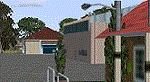
YBLT (Ballarat Aerodrome) is a regional 'airport' in the central west of the State of Victoria, Australia and utilises infrastructure from the days of RAAF operations which lasted till the early 1960's. Thus the buildings are now a bit outdated but this file does not reflect that as I have not done any custom texturing so everything in this package tends to look a bit new and crispy.
Note the name of this 'airport'. The locals are adamant it is an aerodrome, not an airport. I have not found any freeware or commercial offerings for an alternative to the default and so I have put one together.
This is a reasonable approximation of the airport /aerodrome but is not entirely accurate as the hangars/buildings I have modelled myself are generic ones I have done and do not look exactly like the ones at that facility. The connecting road is not in true alignment as I have created it so as it blends into the surrounding default scenery.
| Filename: | YBLT__Ballarat_Aerodrome__Victoria_Australia.zip |
| License: | Freeware |
| Added: | 21st October 2014, 01:51:16 |
| Downloads: | 841 |
| Author: | Robert Budd |
| Size: | 4.43 MB |
| Category: Flight Simulator 2004 - Scenery | |
| PASY - Shemya (Eareckson Air Station) - Alaska, USA |
|
Images related to this file:
File Description:
Shemya is pretty well AT the western end of the Aleutian chain of islands in Alaska, around 240 miles west of Amchitka. There is no town on Shemya and the whole island is occupied (and owned) by the Air Force. There are three runways, two of which are from the 1940's and are now unused; in fact one of them has been partly ploughed up and also used for outdoor storage. The single in-use runway is aligned 10-28 and is 10,000 feet of 150 feet wide asphalt with an ils on 28, the runway that is used 99% of the time. The base is now not active but is maintained as a refuelling facility, so for landing and takeoff purposes it is open. The older and now unused areas are those where the hangers are slowly rusting away and the asphalt is turning green with encroaching and well-watered wildlife plants. The tower is now closed, so there is no atc and you just announce your intentions. Read the history of Shemya, a lot happened there.
| Filename: | PASY__Shemya_Eareckson_Air_Station__Alaska_USA.zip |
| License: | Freeware, limited distribution |
| Added: | 18th February 2015, 19:52:36 |
| Downloads: | 453 |
| Author: | Roger Wensley |
| Size: | 8.81 MB |


© 2001-2026 AVSIM Online
All Rights Reserved
Privacy Policy |