
Where Flight Simulation Enthusiasts Gather from Around the World!
AVSIM Library - Search Results

| Category: Flight Simulator 2004 - Scenery | |
| Chilko Lake CAG3 & Scum Lake CAW3 in British Columbia Canada |

|
Images related to this file:
File Description:
Chilko Lake and Scum Lake are both on the eastern side of the Coast Mountains of British Columbia. Chilko Lake CAG3 is around 30 miles south of Puntzi Mountain and at the northern end of the lake, serving Tsylos Park Lodge, which caters for trekking, horse riding, mountain biking, fishing etc. The runway is 3,200 feet of gravel aligned 18-36 and unlit, at 3,850 feet ASL (above sea level). Scum Lake is around 30 miles southeast of Puntzi Mountain and 25 miles northeast of Chilko Lake. Don't ask me about the name. The airstrip appears to serve a small village and is noted as "private", so perhaps also a lodge operation. The runway is 3,500 feet of gravel aligned 03-21, unlit and at 3,921 feet ASL. I have posted these as a separate scenery, but I suggest that you just add it to your previously created "BC airfields" and avoid the inevitable doubling up of common textures etc. Plus that way you will have just one FS9 library post to do and new airfields will not need yet another posting. Up to you. If you find a defect, email me.
| Filename: | Chilko_Lake_CAG3__Scum_Lake_CAW3_in_British_Columb.zip |
| License: | Freeware, limited distribution |
| Added: | 21st November 2020, 18:24:29 |
| Downloads: | 117 |
| Author: | Roger Wensley |
| Size: | 11.85 MB |
| Category: Flight Simulator 2004 - Scenery | |
| Lutselk'e CYLK in the Northwest Territories, Canada |
|
Images related to this file:
File Description:
Lutselk'e is a village on the southern shore of the Great Slave Lake, at the eastern end and about 120 miles east of Yellowknife. The Hudson Bay trading company established a post there in 1925, and the current school opened in 1960. The population is in the region of 330. There is no road access, but the government runs a freight shipping service during the ice-free period of the Summer. The airfield is a mile or so east of the village, with a runway of around 3,500 feet of gravel aligned 08-26 with PAPI at both ends and lit, with lights atop traffic cones. There are scheduled flights from Yellowknife by Air Tindi, included in the AI, as is a once a week freight flight by Buffalo Airways. You will need to have downloaded and installed my runway and taxiway lighting library from recent posts. A note here about my scenery making. There will not be many more to follow this as I am almost at the end of the photos I either took or found for scenery purposes, plus I expect to move on from FS9 at some point during next year.
| Filename: | Lutselke_CYLK_in_the_Northwest_Territories_Canada.zip |
| License: | Freeware, limited distribution |
| Added: | 9th December 2019, 18:04:52 |
| Downloads: | 107 |
| Author: | Roger Wensley |
| Size: | 3.25 MB |
| Category: Flight Simulator 2004 - Scenery | |
| Wekweeti CFJ2 in the Northwest Territories, Canada |
|
Images related to this file:
File Description:
Wekweeti is a small village in the Northwest Territories, around 120 miles north of Yellowknife and 100 east of Gameti, which was recently posted. It has a population of around 125. There is no all-weather road access and the village is reliant upon the airfield for supplies, along with an ice road in the winter months. The area is a complex collection of lakes and small rivers and the airfield is around 3 miles east of the village on a lake shore. The lit gravel runway of 3,400 feet with PAPI at both ends is aligned 307T-127T with T standing for "true" and not the unreliable magnetic heading in the Canadian northern domestic airspace. The airfield is served by Air Tindi from Yellowknife on an almost daily basis, included in the AI here along with some GA and a Thursday delivery by a Buffalo DC3. A note here about my scenery making. There will not be many more to follow this as I am almost at the end of the photos I either took or found for scenery purposes, plus I expect to move on from FS9 at some point during next year.
| Filename: | Wekweeti_CFJ2_in_the_Northwest_Territories_Canada.zip |
| License: | Freeware, limited distribution |
| Added: | 4th January 2020, 18:23:59 |
| Downloads: | 154 |
| Author: | Roger Wensley |
| Size: | 4.39 MB |
| Category: Flight Simulator 2004 - Scenery | |
| Ferndale 53U in Montana US |
|
Images related to this file:
File Description:
I have made this because I downloaded and tried the Glacier Park photo land-class scenery by Blue Sky Scenery and then rediscovered that the airfield runways are not correctly positioned or aligned in FS9. So I corrected the Ferndale runway and while I was there also added 33 hangars and some parked planes. Of course, as all I know about the hangars is the colour of the roof this isn't up to total realism. It is, however, better than nothing and as I have a large stock of hangars from other sceneries not much effort was involved.
Ferndale is an "airpark" type of airfield where folks build their houses and hangers around the field, plus it also has a bunch of hangars; it is the "bunch" that I have replicated, as I have no idea at all what the houses look like. The field is 20 miles southeast of Glacier Park International at 3,060 feet ASL and around 55 miles south of the Canadian border. There are no large towns close by; the nearest would be Missoula, which is some 70 miles further south.
| Filename: | Ferndale_53U_in_Montana_US.zip |
| License: | Freeware, limited distribution |
| Added: | 29th May 2010, 17:54:14 |
| Downloads: | 291 |
| Author: | Roger Wensley |
| Size: | 2.26 MB |
| Category: Flight Simulator 2004 - Scenery | |
| Aklavik CYKD in the Northwest Territories, Canada |
|
Images related to this file:
File Description:
Aklavik is a town of 650 or so inhabitants at N68 W135, which means 120 miles inside the Arctic Circle and on the West Channel of the Mackenzie River delta. It is 40 miles west of Inuvik and around 60 miles from where the Mackenzie meets the Beaufort Sea. There is only one airline serving the town on a regular basis and that is North Wright, which is headquartered in Norman Wells and also has a base in Inuvik. Aklavik village does not feature in FS9, so the first thing to do was to add it; not all the smaller streets are in place but it is the right shape and with around the right number of houses. The only building with (partly) correct textures is the school near the airfield. I couldn't begin to model 150+ houses, so think of it as a hand-made auto-generated village. I had to move the airfield over beside the river, so there is a DELETE file and a GRASS file, as well as an AFCAD for AI (the AI will follow later) and a scenery file.
| Filename: | Aklavik_CYKD_in_the_Northwest_Territories_Canada.zip |
| License: | Freeware, limited distribution |
| Added: | 10th October 2010, 03:02:19 |
| Downloads: | 630 |
| Author: | Roger Wensley |
| Size: | 1.91 MB |
| Category: Flight Simulator 2004 - Scenery | |
| Ivujivik CYIK in Hudson Bay, Quebec, Canada |
|
Images related to this file:
File Description:
Ivujivik is a village of 350 or so inhabitants at N62 25 W78 on the northeastern corner of Hudson Bay. The village does not feature in FS9 but is included in this scenery with approximately the right shape (the coast, even with UT, is not exactly right) so just think of it as a hand-made auto-generated village which gives the airfield a reason. The runway is 3,500 feet of gravel 100 feet wide, which should be enough. I also added the roads, deleted the stock airfield background and added a new background, plus of course there is the scenery file and the AFCAD and AI. You may note that the terminal has the elevation written on the sign as 126', while on the winter photo it is written on the older & bigger sign as 130'. I thought this is because satellite radar has fixed the elevations of all airfields more accurately than before, as Rockcliffe too has gone from 192' to 188'; the alternative explanation is that global warming has raised sea level by 4'. Wow! That's a thought. I presume the new sign was made smaller as a cost saving.
| Filename: | Ivujivik_CYIK_in_Hudson_Bay_Quebec_Canada.zip |
| License: | Freeware, limited distribution |
| Added: | 31st October 2010, 07:41:20 |
| Downloads: | 458 |
| Author: | Roger Wensley |
| Size: | 2.07 MB |
| Category: Flight Simulator 2004 - Aircraft Repaints, Textures and Modifications | |
| Aerolinas Argentinas (NC) Boeing 737-700WL |
|
Images related to this file:
File Description:
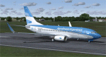
This is a repaint in the "New Livery" of "Aerolinas Argentinas" for the Kitty Hawk 737-700W. This is a complete file and for FS9 (FS2004). While it may work in FSX, installing it in FSX is done at your own risk. All repainted textures have been formatted in 32 bit and have been 100 % hand painted (other than the flag and Argentina Logo). There is ONE problem with this paint that I am aware of. The belly paint concludes at the front edge of the nacelle lines when it should continue through to the wheel wells. For some reason (brain freeze perhaps) I was unable to get the paint work good enough for presentation and decided to stay with what is. I am working on this problem and (if) I can work it out, I will upload the appropriate fix. In line with that - please read the enclosed Read Me file as well. Installation, Distribution and Contact details for me can be found in the enclosed Kitty Hawk TC Read Me file. Sorry for the lack of realism and I hoe this does not stop you from downloading the work as is. Cheers.
| Filename: | Aerolinas_Argentinas_NC_Boeing_737700WL.zip |
| License: | Freeware, limited distribution |
| Added: | 1st March 2012, 16:04:48 |
| Downloads: | 270 |
| Author: | Tony Cannon and Kitty Hawk |
| Size: | 3 MB |
| Category: Flight Simulator 2004 - Scenery | |
| CEN5 - Cold Lake Regional & revised CYOD - Cold Lake, Alberta, Canada |
|
Images related to this file:
File Description:
CYOD was made by John Stinstrom and you should download and install it first; there is also a "fix" for the apron lights textures. I am posting a modified AFCAD for CYOD with John's knowledge; this changes gates and atc identifications for the gates, so that with my version of the CYOD AI there are pairs of F18s taking off every 20 minutes or so. This means that the nearby Cold Lake Regional CEN5 works within the busy environment of flights to and from the nearby base. There is also a Hawker Hunter that drops in, and transport planes. The planes are listed so that you will know which are required to be downloaded. CEN5 may have "Regional" attached to its name, but there are now no scheduled flights and it is a peaceful and relaxed little airfield. There is fuel, and a little clubhouse building, and some hangars. There is ai for it here, using original FS9 planes so no downloads are required. Right hand circuits for runway 25 to stay as far away as possible from CYOD, and it is the CYOD tower that controls all flights in the area.
| Filename: | CEN5__Cold_Lake_Regional___revised_CYOD__Cold_Lake.zip |
| License: | Freeware, limited distribution |
| Added: | 11th May 2014, 13:41:51 |
| Downloads: | 489 |
| Author: | Roger Wensley |
| Size: | 12.25 MB |
| Category: Flight Simulator X - Panels | |
| Ultimate Airbus A32x V2 |
|
Images related to this file:
File Description:

Ultimate Airbus A32x V2 is an Advancement of the previous Version "Ultimate Airbus V1" and generally follows the same Idea: To ease flying the WILCO Airbus Volume 1 (models A318, A319, A320 and A321). This Package therefore introduces 6 smaller Sub-Panels (p.e. Engine Starter, ECAM Control, Flaps Lever, Radio etc. including Clickspots to handle those Panels) instead of allways using the Pedestal or Overhead Panel covering the complete View. It also includes a "Co-Pilot" functionality to automate certain Parts of Flight Procedures (Lights, Gear, Spoliers, Flaps etc.), Buttons for Panel Lights and Doors as well as new Views.
A detailed Tutorial Flight considering the a. m. added functionality - based on Airbus Original Procedure- and Checklist but modified to fit with the functionality available in WILCO's Airbus Volume 1 - is also Part of this Package. It is especially written for Beginners because there is no such detailed Tutorial currently available.
This zip-file contains the FSX version only which is slightly different from the FS9 version. More detailed information on this package as well as on installation you will find in the "Readme_ExtVers_FSX.pdf" file.
| Filename: | Ultimate_Airbus_A32x_V2.zip |
| License: | Freeware |
| Added: | 10th March 2010, 23:44:24 |
| Downloads: | 7,059 |
| Author: | Steffen Froemter / Rolf Fritze |
| Size: | 3.13 MB |
| Category: Flight Simulator 2004 - Scenery | |
| Alaska South Slope 2 - Noorvik ORV in AK US |
|
Images related to this file:
File Description:
The town of Kotzebue is in the far northwest of Alaska, and these are villages to the north and the east of Kotzebue on the South Slope of the Brooks Range of mountains. There will be further additions. Noorvik is a small village (population now around 670) on the bank of the Kobuk River, around 50 miles east of Kotzebue. The new airfield is 1 mile south of the village; there is a short runway immediately south of the town that is now closed but is not marked as such and appears to be usable; this will still be listed in FS9 when you are presented with a choice of runways but is not connected in any way to the new airfield so ignore it. The new ORV runway has 4,000 feet of lit gravel aligned 06-24. There are scheduled flights by Era (now renamed Ravn) and by Bering Air, both of them originating in Kotzebue and routing east to Noorvik, Kiana, Ambler, Shungnak, Kobuk, and then back again. The AI includes these flights (eventually) plus perhaps an Everts Air cargo flight and GA.
| Filename: | Alaska_South_Slope_2__Noorvik_ORV_in_AK_US.zip |
| License: | Freeware, limited distribution |
| Added: | 4th September 2016, 18:20:02 |
| Downloads: | 221 |
| Author: | Roger Wensley |
| Size: | 3.95 MB |


© 2001-2026 AVSIM Online
All Rights Reserved
Privacy Policy |