
Where Flight Simulation Enthusiasts Gather from Around the World!
AVSIM Library - Search Results

| Category: Flight Simulator 2004 - Aircraft Repaints, Textures and Modifications | |
| Hellenic Navy Air Force, Sopwith Pup |

|
File Description:
The Sopwith Pup was a British rotary-engined fighter of the middle period of WWI. The 'ÍáõôéêÞ ÁåñïðïñéêÞ Õðçñåóßá' (N.A.Y./ Hellenic Navy Air Force) received, during 1917, four planes of this type and, based on Moudro's Airport, they were the first Hellenic fighters used over the Aegean Sea.
Texture set only for an aircraft belonged to the N.A.Y. during the period 1917/18. These textures require the original FS9 Sopwith Pup package by Stephen O'Leary. Repaint by Manuele Villa, February 2008.
| Filename: | Hellenic_Navy_Air_Force_Sopwith_Pup.zip |
| License: | Freeware |
| Added: | 19th February 2008, 09:44:08 |
| Downloads: | 146 |
| Author: | Manuele Villa |
| Size: | 664.12 KB |
| Category: Flight Simulator 2004 - Scenery | |
| Maroc_sc_Supplement |
|
File Description:
These files are for anyone who has installed Toni Agramont's scenery files for Morocco (maroc_sc.zip - available from a number of FS sites on-line: a web search will easily locate them) and wants to remove the static aircraft from the airport sceneries. A large number of these planes are unpainted, so appear as white 'ghosts', and also can end up being superimposed upon dynamic FS9/Ultimate Traffic etc. AI traffic at a number of locations. A few other small alterations ...
| Filename: | Maroc_sc_Supplement.zip |
| License: | Freeware |
| Added: | 6th November 2009, 08:36:21 |
| Downloads: | 6,398 |
| Author: | Martin Stebbing |
| Size: | 963.19 KB |
| Category: Flight Simulator 2004 - Utilities | |
| LJSceneGen V 1.0 |
|
File Description: LJSceneGen is a scenery creation utility for the Microsoft (MS) Flight Simulator FS9 (aka FS2004 or Century of Flight). The program presents a series of forms where various options for VORs, NDBs, Exclusion Rectangles, Markers, Waypoints and Scenery Library objects can be entered. The program will try to connect FS9 via FSUIPC or WideFS. If a FSUIPC connection is found, the location (Lat. Long. and Alt and others if available and appropriate) will be automatically retrieved. You can also move the aircraft to a new location by entering a Lat. and Long. pair and clicking "Move Aircraft". Multiple combinations VORs, NDBs, Exclusion Rectangles, Markers, Waypoints and Scenery Library objects can be saved and each saved object can be edited. After all the desired objects are created, an XML file can be created. This file can be submitted to the FS2004 SDK BGL compiler "BGLCOMP.exe". A file with an extension of .BGL will result which you then place in your Addon Scenery/scenery/ folder to view your just created scenery object(s) after you restart FS9. This or other properly formulated .XML scenery files can be imported and reviewed. For example, the FS9 file NVNAMC0.bgl can be decompiled, imported into LJSceneGen and then viewed. Alessandro Antonini's excellent BGLXMLdecompiler program makes possible the conversion from NVNAMC0.bgl. to NVNAMC0.xml which can then be read by LJSceneGen. (This file is available at Alec's site: http://www.cpinf.net ). Each VOR and NDB found in this decompiled xml file can be reviewed and if you want, you can move your aircraft to the object's location by clicking "Move Aircraft". This program is written in MS's C# language using .NET framework 1.1. The CLR .NET Framework 1.1 must be installed on your computer before the program will run. The freeware version of Pete Dowson's FSUIPC is not supported. Users should be very familar with the FS2004 scenery SDK. This version only knows VORs, NDBs, Exclusion Rectangles, Markers, Waypoints, and Scenery Library objects. It doesn't yet know about Airports Runways ILSes etc. This is not a "What You See Is What You Get" program but instead takes a semi-automated fill-in-the-blanks approach. The program is a scenery creation utility. As such, inexperienced scenery designers may not find it user friendly.
| Filename: | LJSceneGen_V_10.zip |
| License: | Freeware, limited distribution |
| Added: | 14th March 2004, 01:10:12 |
| Downloads: | 2,411 |
| Author: | Larry Jones |
| Size: | 469.34 KB |
| Category: Flight Simulator 2004 - Scenery | |
| Nenana Municipal Airport PANN in Alaska |
|
Images related to this file:
File Description:
Nenana is a village on the river of the same name around 40 miles west of Fairbanks, which is the second largest urban area in Alaska after Anchorage. Nenana, as a result of this proximity, is served by road and railway and unlike other Alaskan villages is not reliant on air cargo for necessities. The current population is just under 400, which is way down from its peak of 5,000 in the 1920's when gold was being mined and the railroad being built. Nenana's main claim to fame is as the starting point for the 1925 mushing delivery to Nome of the serum to combat an outbreak of diphtheria. Any Nenana Municipal Airport history is difficult to find, even the date of construction. It has two runways 3L-21R and 3R-21L, the first being asphalt and just under 5,000 feet with PAPI at both ends, the second grass and 1,800 feet. Both are lit. It also has a further water runway similarly aligned and 3,000 feet long. Maintenance is available and there is also fuel at the end of the northern apron, close to the crashed and stripped DC4 that sits among other unwanted items that are too large to make it worth the cost of moving them off the site. There are no regular scheduled flights to the airport, with air taxi or owner operated being in the majority. The scenery, in addition to the terrain, town, bridges, and airport items also modifies the terrain in an area further south where FS9 depicted as a city an Air Force base that is mainly concerned with radar and communications and in fact has very few buildings. The AI includes some Beavers on floats that were used in previous BC scenery with the kind permission of FSAddon. As I have already posted them I have not included them again here. The float plane AI uses the same radio frequency as the land based planes, but they fly to PANX and not to PANN as FS9 has problems with getting floats and wheels separated. Or maybe I just haven't worked out how to cope with FS9. A note here about my scenery making. There will not be many more to follow this as I am almost at the end of the photos I either took or found for scenery purposes, plus I expect to move on from FS9 at some point during next year.
| Filename: | Nenana_Municipal_Airport_PANN_in_Alaska.zip |
| License: | Freeware, limited distribution |
| Added: | 2nd December 2019, 18:12:42 |
| Downloads: | 156 |
| Author: | Roger Wensley |
| Size: | 7.36 MB |
| Category: Flight Simulator 2004 - Scenery | |
| PABA - Barter Island (Kaktovik) - Alaska North Slope 8 |
|
Images related to this file:
File Description:
The town of Barrow is in the far north of Alaska, and these are coastal villages or radar installations to the west, south, and now east of Barrow. There will be further additions. Barter Island is a DEW station Air Force base 310 miles east of Barrow and 75 miles east of Bullen Point. The runway is just under 5,000 feet of gravel and aligned 06-24 on a spit of land at the northeast corner of the island. The big hangar is still there on the apron. Most of the DEW buildings have now been removed but this scenery is dated around 2005 when there were more of them still there. Between the DEW station and the airstrip is the village of Kaktovik, with a population of some 300 mainly traditional Inupiat. The village was first pioneered when the DEW station was built in the 1950's and grew as the years passed. The FS9 error discovered when making this scenery was that FS9 had mistakenly "placed" Kaktovik at Bullen Point (not physically, it was just wrongly stated as the local town); this is now only partly corrected as FS9 refused to accept my Bullen Point revision but allowed me to associate Kaktovik with Barter Island. Kaktovik is definitely on Barter Island. I could also mention that the runway was in the sea, but there isn't much point in that as Bill would say it was all the fault of Ultimate Terrain, so I won't bother. The next DEW station to the east is in Canada and called Komakuk; this has already been made and posted. The next in this series will be far to the west. The AI has daily flights by ERA, plus Northern Air Cargo, and some GA.
| Filename: | PABA__Barter_Island_Kaktovik__Alaska_North_Slope_8.zip |
| License: | Freeware, limited distribution |
| Added: | 19th July 2016, 17:49:16 |
| Downloads: | 210 |
| Author: | Roger Wensley |
| Size: | 3.42 MB |
| Category: Flight Simulator X - Aircraft Repaints, Textures and Modifications | |
| Flying Colours Airlines Boeing 757-28A (G-FCLB) |
|
Images related to this file:
File Description:
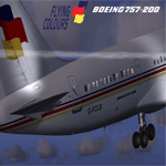
Flying Colours Airlines repaint in G-FCLB 757-200 colours for the Quality Wings 757 collection. Flying Colours was a UK Charter airline based in Manchester, UK. It commenced operations in 1996 ceasing in 1999 when it was acquired by the Thomas Cook group subsequently being rebranded JMC Airlines then rebranded again in 2002 under its owners brand Thomas Cook in which it still operates to date in Thomas Cook UK livery. Only tested in FSX should work fine in FS9. Requires Quality Wings 757 Collection.
| Filename: | Flying_Colours_Airlines_Boeing_75728A_GFCLB.zip |
| License: | Freeware |
| Added: | 15th May 2010, 08:46:42 |
| Downloads: | 647 |
| Author: | Jason Smart, Quality Wings Simulations |
| Size: | 8.58 MB |
| Category: Flight Simulator 2004 - AFCAD Files | |
| KDALv0711 |
|
Images related to this file:
File Description:

KDALv0711 zip contains 2 bgl's (1 afcad and 1 for building placement).
This is a complete redo of the AP.
I used Google Earth for measurements, the current airport diagram, and info from the KDAL website for current gate assignments.
They are starting major redevelopment to make 1 large terminal, replacing the 3 current terminals. My afcad reflects some of the removed buildings. I will update when construction is complete.
Created with AFX and is for FS9 ONLY to replace the default AP.
Have Fun, Joe
| Filename: | KDALv0711.zip |
| License: | Freeware |
| Added: | 17th July 2011, 09:42:42 |
| Downloads: | 390 |
| Author: | Joe Bourgeois |
| Size: | 93.12 KB |
| Category: Flight Simulator X - AFCAD Files | |
| Paramount Bistcho, Alberta, Canada |
|
File Description:
The AFCAD (ADE) for Paramount Bistcho was left out of our Sunwest Aviation Summer 2011 flightplan & repaint package. One of the destinations for Sunwest's B1900Ds is Paramount Bistcho in Northern Alberta. It's assigned designator is CPB8 but in both FS9 & FSX CPB8 is given to Rodney, Ontario (which should be CPU3). It is impossible to change a "stock" airport's designator in FS so we have designated Paramount Bistcho as CPB1 which is a designator not used in the real world at this time. Produced with ADE v1.50.01.
| Filename: | Paramount_Bistcho_Alberta_Canada.zip |
| License: | Freeware |
| Added: | 10th September 2011, 16:39:08 |
| Downloads: | 176 |
| Author: | Steve Lewis & Darren Belanger |
| Size: | 3 KB |
| Category: Flight Simulator 2004 - AFCAD Files | |
| Paramount Bistcho, Alberta, Canada |
|
File Description:
The AFCAD (ADE) for Paramount Bistcho was left out of our Sunwest Aviation Summer 2011 flightplans & repaint package. One of the destinations for Sunwest's B1900Ds is Paramount Bistcho in Northern Alberta. It's assigned designator is CPB8 but in both FS9 & FSX CPB8 is given to Rodney, Ontario (which should be CPU3). It is impossible to change a "stock" airport's designator in FS so we have designated Paramount Bistcho as CPB1 which is a designator not used in the real world at this time. Produced with ADE v1.50.01.
| Filename: | Paramount_Bistcho_Alberta_Canada.zip |
| License: | Freeware |
| Added: | 10th September 2011, 16:39:19 |
| Downloads: | 183 |
| Author: | Steve Lewis & Darren Belanger |
| Size: | 2.15 KB |
| Category: Flight Simulator 2004 - AI Flight Plans | |
| King County Int'l - Boeing Flight Test Center Flightplans Fall 2010 |
|
File Description:
King County International Airport is located 5 miles south of downtown Seattle and is Boeing's final test site for the 737 and 787. Enclosed flight plans for 25 aircraft undergoing final tests prior to delivery to their respective airlines as of September, including the USAF E-3C prototype and the Boeing corporate Cessna 208B which ferries Boeing employees between the test sites are included. Also, AFCADs for KBFI for both FSX and FS9 are included to support these flightplans. Updates my boeing_field_kbfi.zip upload of March 2004.
| Filename: | King_County_Intl__Boeing_Flight_Test_Center_Flight.zip |
| License: | Freeware |
| Added: | 29th September 2010, 16:25:34 |
| Downloads: | 1,297 |
| Author: | Steve Lewis |
| Size: | 714.09 KB |


© 2001-2026 AVSIM Online
All Rights Reserved
Privacy Policy |