
Where Flight Simulation Enthusiasts Gather from Around the World!
AVSIM Library - Search Results

| Category: Prepar3D V1-4 - Utilities | |
| AICull In-Sim Traffic Density Setting Tool |

|
Images related to this file:
File Description:

AICull v1.0.1 is a simconnect utility designed to provide AI traffic limiter options from within the P3D simulation via a menu system located under the “Add-ons†menu. AICull uses a “Smart Retain X Current ICAO†mode (accessible via the AICull in-sim menu under add-ons) that automatically maximizes arrival and departure activity at the user’s current ICAO while still retaining “X†number of AI. Alternately,the user can chose to simply retain “X†number of AI closest to the user’s aircraft. AICull also provides the options to limit AI traffic to the user’s departure and destination airports (if a P3D flight plan loaded). In all of the above cases, exceptions can be made for enroute AI (e.g., higher than 10,000 ft AGL or 18,000 ft AGL). The user can also customize preset values for the “X†retention number. AICull works best for .bgl file based traffic solutions (e.g., AIG). Although AICull will also work with simconnect-based traffic injectors (e.g., UTL), they typically perform their own AI traffic limiting and may also re-inject traffic that AICull deletes. AICull require the installation of FSUIPC v5 or later, registered (preferred) or unregistered. AICull is fully compatible with AIFlow and AIGround. Ver 1.0.1 FIX: changes to AICull.ini file not being read.
| Filename: | AICull_InSim_Traffic_Density_Setting_Tool.zip |
| License: | Freeware |
| Added: | 10th July 2020, 18:21:59 |
| Downloads: | 704 |
| Author: | Roland Foster |
| Size: | 946.98 KB |
| Category: Flight Simulator 2004 - Scenery | |
| Hazyview Airfield, Hazyview, South Africa |
|
Images related to this file:
File Description:
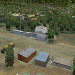
Hazyview is one of the gateway towns to the Kruger National Park and is located just to the West of Phabeni Gate, one of the main gates to use if you are travelling to Skukuza. The airfield in Hazyview is also called Numbi Airfield due to the location of the Numbi Hotel right next to the airfield.
Hazyview airfield is not included in the default scenery of FS2004. With this package, it has been faithfully produced in Gmax with photoreal textures on all the buildings and a photoreal ground as well. Even the Lowveld mall to the North of the airfield and right on the approach to Rwy 19 as well as the Building supplies store to the south and on approach to Rwy 01 is inlcuded with custom models and textures. Likewise, the buildings to the West of the runway (right at the edge of the runway) and the brickyard at the Northern end is modeled with custom models and textures. The two large cellphone antennas are also present in the airport scenery and custom made.
In real life, the runway is quite sloped and this was also recreated in the scenery under the limitations FS2004 presents with regards to non-flat airports.
The grass runway is aligned 01/19 and only 820m long. Take-off is on Rwy 01, with landings on Rwy 19.
| Filename: | Hazyview_Airfield_Hazyview_South_Africa.zip |
| License: | Freeware, limited distribution |
| Added: | 4th February 2022, 14:57:40 |
| Downloads: | 143 |
| Author: | Kobus van Wyk |
| Size: | 17.07 MB |
| Category: Flight Simulator 2004 - AI Flight Plans | |
| Sorted default FS9 flight plans & GA flight plans sorted by ICAO/country |
|
File Description:
The Master_GA_sorted_country contains: some 20,436 flight plans that have been adopted from Reggie Fields' sorted aircraft registration collections. The following is from his readme file (included folder), "FS2004 General Aviation AI traffic with more correct registration numbers for the originating country. This file is a modification of the FS2004 default GA traffic designed to minimize the number of small single engine aircraft landing at the worlds major commercial airports. This will prevent a lot of go-around orders to commercial jets based on the length of time it takes a C172 to clear a 10,000 ft runway. This file makes commercial AI traffic flow much better than the MS default while retaining the GA aircraft in the airspace." Like Reggie Fields' files, all are free to use and redistribute but can not be sold. AC#defaultfp_sorted_ICAO folder contains all individual default aircraft in seperate files and their FS9 default flight plans are sorted by ICAO. A second folder contains a file for each country with the mentioned GA flight plans sorted by ICAO. This should be of an aide to those of us who wish to put more correct AI aircraft into a region or country. Copy/paste should be easier, this way, when building on each countries' aviation/flights. All files are text (.txt) files (ASCII.) They have no @ and TTOOLS by Lee Swordy is recommended.
| Filename: | Sorted_default_FS9_flight_plans__GA_flight_plans_s.zip |
| License: | Freeware |
| Added: | 10th May 2004, 14:48:30 |
| Downloads: | 2,983 |
| Author: | Rick Connolly |
| Size: | 5.57 MB |
| Category: Flight Simulator 2004 - Miscellaneous Files | |
| Active ILS - KMIA (Miami International Airport) |
|
File Description:
By design KMIA is now the most advanced ATC controlled airport in the FS9 database. This is the 4th Airport and the most complex in a series of new ILS runways. As most know initiating the ILS at certain airports for AI Traffic is not a function at this time when using AFCAD2. If you add a new ILS runway to an airport such as KMIA (Miami International Airport 8L/26R) only the user aircraft can use this runway when visibility falls below 3 miles. ATC will no longer use this runway for AI Traffic because FS9 sees it as a visual runway. This will cause ATC to vector your AI Traffic back to 9L/27R (old numbers) 8R/26L (new numbers) which is also a Terminal departure runway. All 4 runways for KMIA are now simultaneously active for both departure and arrival. In the past only the runways closest to the Terminal were for departure, and arrivals used the outer parallel runways. This no longer applies with KMIA. The many options written in the XML are to numerous to list for KMIA so follow the instructions in the README and just sit back (or fly) and plane spot either VMC or IMC for a very active airport.
*** FlyTampa-Miami Scenery AFCAD2 and special ILS bgl also included ***
| Filename: | Active_ILS__KMIA_Miami_International_Airport.zip |
| License: | Freeware, limited distribution |
| Added: | 4th July 2004, 03:33:01 |
| Downloads: | 2,217 |
| Author: | Jim Vile |
| Size: | 128.67 KB |
| Category: Flight Simulator 2004 - Flight Plans | |
| Crossing North America Flight Adventures-Package 3 |
|
File Description:
Inspired by Michael Doherty (Difficult & Dangerous Approaches) and David Dossiere (Hopping Round the World) and their flight adventures, I have put together a series of flight plan-adventures where the aircraft used are all available as freeware. A file locator is included with each package so that you can easily find and download the aircraft used. These packages each contain 10 flight adventures and each package begins at the location the previous package ended. All flightplans are VFR only and are designed so that you can enjoy the outstanding scenery of Alaska, Western Canada, Western and Mountain States of the lower 48, and Mexico.
The adventure, Crossing North America, begins at Pt Hope, Alaska and will conclude in the following months at Cancun, Mexico. The aircraft used are: General Aviation, Vintage, Warbirds, Bush Aircraft, and Propliners. No IFR flightplans or jets!
The flightplans are NOT designed to get you from Alaska to Mexico by the shortest route possible, but are in the spirit of David Dossiere's "Hopping Round the World" adventure flights, in that they take you into as many areas or airports as possible. Looking for some fun, flying low, and enjoying the scenery, then these flight adventures are for you.
Todate: 3,769 miles covered, using 26 different aircraft in the first 3 flight packs!
| Filename: | Crossing_North_America_Flight_AdventuresPackage_3.zip |
| License: | Freeware |
| Added: | 6th July 2004, 14:46:46 |
| Downloads: | 4,074 |
| Author: | Steve (Bear) Cartwright |
| Size: | 1.37 MB |
| Category: Flight Simulator 2004 - Miscellaneous Files | |
| Active ILS - LEBL (El Prat - Barcelona Airport) |
|
File Description:
As most know initiating the ILS at certain airports for AI Traffic or the User Aircraft is not a function at this time when using AFCAD2. If you add a new ILS runway to an airport such as LEBL (El Prat/Barcelona 7R/25L) only the user aircraft can use this runway (without ATC commands) when visibility falls below 3 miles. ATC will no longer use this runway for AI Traffic because FS9 sees it as a visual runway. This will cause ATC to vector all your AI Traffic back to runway 7/25 old numbers, 7L/25R new numbers which is also a Terminal departure runway. This ILS bgl file adds all NAVAIDS for making 7R/25L a Precision Instrument Runway by adding all the radar fixes for both the ILS approach portion and the missed approach procedures, altitudes and intersections as per current published plates. All AI Aircraft/User Planes will now continue to use the new 7R/25L runway when Airport weather conditions are less than 3 miles. ATC will also use the right naming/numbers of the runways. The DME/VOR approaches have also been written using the new BCN/PRA VOR's for runways 7L/25R and 02. Many different default FS9 scenery GUID's added including Taxiway Signs *** FS2004 Default Scenery AFCAD2 included with the new 7R/25L runway ***
| Filename: | Active_ILS__LEBL_El_Prat__Barcelona_Airport.zip |
| License: | Freeware, limited distribution |
| Added: | 30th December 2004, 17:53:42 |
| Downloads: | 2,842 |
| Author: | Jim Vile |
| Size: | 31.51 KB |
| Category: Flight Simulator X - Original Aircraft | |
| Mirage F.1CG Hellenic Air Force |
|
File Description:
On 16 June 1974 the contract for 40 Mirage F.1CG.s was signed and the deliveries were scheduled to last from 1977 until 1979. Because of the invasion of Cyprus by Turkey, in July 1974, the Mirages delivered on 5 August 1975. The Greek F.1CGs aircraft entered service with the 342 Mira, which at the time was still using the F-102A Delta Dart as an all-weather interceptor. The last Delta Daggers in HAF service would be retired in 1977 when all 40 F.1CGs were delivered. Unfortunately the Hellenic Air Force Staff did not buy any of the French AA missiles to equip the new fighters and so these had to be armed with US-supplied AIM-9Js instead. In 1984 the KETA (Center for Research and Aviation Technology) stared to develop the wiring for the 2 outboard underwing pylons, in order to make F.1Cgs able to carry 4 AAM instead of 2. This happened with Dassault's help by 1985 and ever since the PA Mirage tooth four AIM-9P-2. After the arrival of more modern types in PA service, the Mirage E.1CG's started to become secondary in PA planning and air operations. In 2000 344 Mira disbanded and all it’s aircraft and personnel passed on to 342 Mira. After almost 28 years of service, on 30 June 2003 the remaining 24 F.1CG's were retired at Tanagra AB. In total, the PA logged no less but 160.000+ flying hours with its F.1CGs, which means 5500-6000 per airframe - and many of these - over 3.500+ hours - in "live" interceptions over the Aegean Sea, under combat-similar conditions. Features: panel, Virtual Cockpit, four Textures, Sounds, msonic boom effect, reworked and more accurate flight dynamics.
| Filename: | Mirage_F1CG_Hellenic_Air_Force.zip |
| License: | Freeware |
| Added: | 26th June 2007, 10:53:15 |
| Downloads: | 34,749 |
| Author: | Thanasis Delizisis, Panagiotis Delizisis, Kirk Olsson |
| Size: | 33.76 MB |
| Category: Flight Simulator X - Scenery | |
| LFMQ - Le Castellet |
|
File Description:
Welcome to Le Castellet Airfield -
This airfield is situated few Nm east of Marseille Provence - LFML, in the south of France. On the 1,000 hectares of plateau he acquired between Marseille and Toulon, Paul Ricard, forever motivated by innovation and development, constructed in 1962 the largest
private airfield in the Provence-Alpes-Côte d’Azur region.
The landing strip at Le Castellet covered a distance of 1,000 metres and allowed for VFR (Visual Flight Rules) operation. Situated on a plateau at the time free of all economic development, it was above all a private airfield. In 1970, the construction
of the Paul Ricard Circuit nearby created an economic dynamic for the first time on Le Castellet plateau. In 1972, Paul Ricard invested in improvements to the runway, lengthening it from 1,000 to 1,750 metres, thus rendering it capable of
receiving business and private airplanes of up to 38 tonnes.
Over twenty years, Le Castellet Airport saw intense periods of activity due to business and private aviation, notably with the arrival of the first F1 French Grand Prix on the Paul Ricard Circuit in 1971, and more recently, with the creation of the Entreprise Zone at Signes, situated only a few kilometres from the airfield. Stop by for an amazing visit at the medieval village as well, situatued on top of a hill.
Nevertheless, from 1972 to 1999, no investment was made at the airfield. In May 1999, the company Excelis S.A. purchased the site (airfield and circuit) and refurbished and modernised the installations.
A truly amazing place to fly to - I have enhanced the entire apron as it is today, all marking correctly set, acces to runway and the Heli area for the "Eggbeater" fan :)
includes the hangar, building and other things around. Hope you'll enjoy your stay at "Le castellet"!
| Filename: | LFMQ__Le_Castellet.zip |
| License: | Freeware |
| Added: | 24th April 2009, 16:28:59 |
| Downloads: | 2,351 |
| Author: | Daniel Louvet |
| Size: | 986.65 KB |
| Category: Flight Simulator 2004 - AI Aircraft | |
| Chance-Vought F-8 Crusader (Part 1) |
|
Images related to this file:
File Description:

Chance-Vought F-8 Crusader (Part 1). I present a comprehensive AI traffic model package for this classic aircraft of modern military history.
This is an original 8-LOD model, with many animations and features thanks to a growing confidence in XML-coding and making FSDS work for me instead of the other way around.
Nicknamed "The Last Gunfighter", this aircraft was the last production aircraft for the US Navy and Marine Corps which used guns as primary armament, and was in service at the twilight of this age, as well as the dawn of the missile age. Like all combat-experience aircraft, it had a relatively short life during its operational use (only about twenty years or so as a fighter), but was used a little longer as a recce aircraft; and beyond that in export service to France and the Philippines. The Crusader was used extensively in combat operations in Vietnam, played a crucial role in the Cuban Missile Crisis, and gave the newer F-4 Phantoms a fair run for their money in terms of air combat capability during this time.
This is part one of this model series, covering the F-8A, F-8B, and F-8C base models; with a total of 16 model options and a staggering 65 individual squadron paints. I am fairly confident that if any operational squadron of the USN and USMC used this aircraft from the late 50s to the late 60s, it is covered here at some time frame. Subsequent releases will include the later USN/USMC models, as well as the French and Philippine exports. Extensive credits and instructions are in the documentation. Base model and paint by Michael Pearson, flight dynamics by Michael MacIntyre.
| Filename: | ChanceVought_F8_Crusader_Part_1.zip |
| License: | Freeware |
| Added: | 15th November 2012, 17:16:30 |
| Downloads: | 1,140 |
| Author: | Michael Pearson |
| Size: | 18.48 MB |
| Category: Flight Simulator 2004 - Scenery | |
| Bethel PABE in southwest Alaska |
|
Images related to this file:
File Description:
There are four main northwestern Alaska towns which have good airports and are serviced by Alaska Airlines. From these airports local flights connect to nearby villages, "nearby" in Alaska meaning up to 200 miles away. The northernmost is Barrow. Southwest of Barrow is Kotzebue, then Nome, and the furthest south is this one, Bethel. The town of Bethel has a population of just over 6,000 and is 50 miles from the sea on the Kuskowim River, that splits and forks into many tributaries. Bethel Airport is close to the town and provides the only contact with the rest of Alaska, as there is no connecting highway system. There are scheduled flights by Alaska Airlines, ERA (now called Ravn) and Grant Aviation, plus others such as Ryan Air. There are cargo flights by Everts, Northern, and Lynden, and redistribution onwards to nearby villages by the smaller locally-based planes; all of these are included in the AI. There are two main runways, one just under 6,400 feet and another just under 3,900 feet, both of them aligned 19-1. The third runway is around 1,800 feet and mainly gravel, aligned 11-29. Parking at PABE is on three aprons, the northern for smaller commercial planes of Grant, ERA, Ryan etc, the central for larger planes of Alaska, Northern, Everts, and Lynden, and the southern for a large collection of GA; each apron has further hangars for maintenance companies and smaller operators. There is also another separate apron for the local military and Coastguard. There is not much photographic information available for PABE, and I have never been there; as a result it was impossible to make detailed photographic textures for some of the buildings. However, for most hangars I have made textures of at least the right colour etc based on the information I assembled and if it is green with white trim and side windows then that is how it now appears here. The exceptions are the Alaska Airlines terminal building which has complicated curved elements, and the two military hangars and workshops where I had to settle for an Alaska terminal building from another airport and the same for the military. There are numerous small villages in the vicinity of Bethel, all of them being beside either a river tributary or the coast. There are two Google Earth screenshots to show the villages that are served by the flights from Bethel and that are (mostly) included in the AI. Some of these airfields were not included in FS9 but AI will still operate in and out of Bethel. The smaller area screenshot shows the villages that are close to Bethel, and of these eight I have so far made six and they are included in this post: Napaskiak PKA, Napakiak WNA, Kwethluk KWT, Atmautluak 4A2, Nunapitchuk 16A, and Kasigluk Z09. I will work my way through the rest of the area.
| Filename: | Bethel_PABE_in_southwest_Alaska.zip |
| License: | Freeware, limited distribution |
| Added: | 8th March 2019, 00:37:58 |
| Downloads: | 310 |
| Author: | Roger Wensley |
| Size: | 32.02 MB |


© 2001-2026 AVSIM Online
All Rights Reserved
Privacy Policy |