
Where Flight Simulation Enthusiasts Gather from Around the World!
AVSIM Library - Search Results

| Category: Navigation and ATC - Navigation | |
| ChartMap 5.0 |

|
File Description:
ChartMap 5.0 is a small stand-alone Windows utility for Flight Simulators allowing a number of airport charts to be stored and available on screen whilst still flying.
The use of the program is very simple and intuitive. You insert only the Airport ICAO Code and the program will show all the data stored.
The ChartMap 5.0 is a program completely rebuilding with a new graphics power and a new database.
Now is possible to use the PDF format for every kind of charts. You can everywhere download it.
The important thing is to use the conventional letter below in this tutorial (vds IMPORTANT NOTE).
Differences with the previous version:
- Corrected some bugs.
IMPORTANT NOTE:
TO USE THIS PROGRAM YOU NEED DOWNLOAD the charts from Flight Simulator website FOR Italian airport download "Italian Airports Charts and Procedures Series 1, 2 and 3" and unzip in ICAO CODE FOLDER.
| Filename: | ChartMap_50.zip |
| License: | Freeware |
| Added: | 24th November 2013, 16:07:51 |
| Downloads: | 331 |
| Author: | Carlo Chiappisi |
| Size: | 1.51 MB |
| Category: Flight Simulator X - Scenery | |
| Aeropuertos de Isla San Andrés y de Isla Providencia (SKSP & SKPV), Colombia. |
|
File Description:
The delivery includes TWO airports: 1- Gustavo Rojas Pinilla (SKSP) on San Andrés Island, 2- El Embrujo (SKPV) on Providencia Island; both belonging to Colombia (Caribbean Area).
The delivery includes conditioning of the runways and taxiing of the airport facilities using original objects from the FSX Acceleration Pack.
The height of the terrain of the islands was also conditioned, and various objects that force you to take a low-altitude plane or helicopter ride for observation and discovery.
In Providencia you can try a landing approaching by the sea very close to the tropical forest (includes app positions to use gps in flight planner); In the same way, dare to take off on Route 35 without running into the treetops, trusting in your ability.
In San Andrés there will be many tourists on the runway headwaters taking photos of your aircraft arriving or departing from the airport !! They are waiting for you!
| Filename: | Aeropuertos_de_Isla_San_Andrs_y_de_Isla_Providenci.zip |
| License: | Freeware |
| Added: | 8th January 2021, 23:31:13 |
| Downloads: | 871 |
| Author: | Cristóbal Laje Ros |
| Size: | 23.63 MB |
| Category: Prepar3D V1-4 - Scenery | |
| TTCP - A. N. R. Robinson International Airport |
|
Images related to this file:
File Description:
P3Dv4.5 - A. N. R. Robinson International Airport (formerly Crown Point International Airport) - IATA TAB, ICAO TTCP. Version 1.0
A. N. R. Robinson International Airport (formerly Crown Point International Airport - IATA: TAB, ICAO: TTCP) is an international airport located on Crown Point, Tobago in Trinidad and Tobago.
It is located in the southwesternmost part of the island, near the town of Canaan, and 11 km (6.8 mi) from the capital, Scarborough.
The airport is one of two international airports serving the twin isle republic of Trinidad and Tobago.
The other airport is located on the island of Trinidad, Piarco International Airport.
Crown Point International Airport has two terminals. The International Terminal was once both the regional and international passenger terminal for the airport but has been renovated to serve as an all-international terminal. It serves international cargo flights, general aviation and helicopter flights. It has seven aircraft parking positions
This scenario was only tested on P3Dv4.5.
| Filename: | TTCP__A_N_R_Robinson_International_Airport.zip |
| License: | Freeware |
| Added: | 16th June 2022, 06:42:12 |
| Downloads: | 258 |
| Author: | Eduardo Puelker |
| Size: | 21.17 MB |
| Category: Flight Simulator 2002 - AI Flight Plans | |
| World Airways Complete Package |
|
File Description:
This is a complete package for World Airways Inc. This package contains 7 high quality repaints of World Airways' fleet:
McDonnell Douglas MD-11 Regular Livery,
McDonnell Douglas MD-11 White Livery,
McDonnell Douglas MD-11/ER World Airways/Sonair Angola Hybrid,
McDonnell Douglas MD-11F World Airways Cargo,
McDonnell Douglas DC-10-30 World Airways Regular Livery,
McDonnell Douglas DC-10-30 World Airways/Continental Hybrid,
McDonnell Douglas DC-10-30 World Airways With Black Nose,
All repaints are for FSPainter's excellent models, and painted in 32bit to give best quality possible. The repaints are 100% photoreal.All repaints are by Yochai Mossi.
This package also contains accurate flightplans for World Airways's operations accross the world.These flightplans will add more traffic to many airports accross the world from Port Of Spain, Trinidad thru Luanda,Angola to Kuwait and Baharain in the Gulf.
| Filename: | World_Airways_Complete_Package.zip |
| License: | Freeware, limited distribution |
| Added: | 26th September 2003, 01:43:08 |
| Downloads: | 2,903 |
| Author: | Brian Mitchell and Yochai Mossi |
| Size: | 6.28 MB |
| Category: Flight Simulator X - Scenery | |
| YPTN RAAF Tindal, Australia |
|
File Description:
Ants Aussie Airports Vol 5 : RAAF Tindal is a military base about 290kms south east of Darwin near the town of Katherine in Australia's Northern Territory. Tindal is a major front-line operational air base and home to No. 75 Squadron Air Combat Group (F/A-18). There is also a civilian apron in the north west corner of the airfield. This scenery contains photoreal ground textures and these are designed to blend in with the payware FTX textures (available from www.fullterrain.com). It is therefore recommended that you have the FTX textures installed if you wish to see this airfield at its best. I have tried to make this airfield as accurate as possible although as Tindal is a military base there aren't a lot of photos available so a lot of the hangars are "educated guesses". Almost all of the models have been custom made with the use of library objects kept to the minimum.
| Filename: | YPTN_RAAF_Tindal_Australia.zip |
| License: | Freeware, limited distribution |
| Added: | 6th January 2009, 13:49:54 |
| Downloads: | 3,631 |
| Author: | Anthony Lynch |
| Size: | 30.62 MB |
| Category: Flight Simulator 2004 - Scenery | |
| Vintage London Airfields |
|
File Description:
Vintage London Airports for FS2004
Version 1.00, 31 March 2004 freeware
by John McKeon, Limerick, Ireland ([email protected])
for Microsoft Flight Simulator FS9 (FS2004)
Description:
These scenery files represent three airfields, Brooklands, Croydon, and Hendon situated around London, England in the Golden Age of aviation, between 1930 and 1940.
Brooklands, the oldest airfield in the UK, developed inside the classic banked oval motor race track opened in 1909, and was the birthplace of the British aviation industry and the starting point for a number of pioneering flights. Now sadly reduced, Brooklands holds an aviation museum and still operates as an airstrip.
Croydon was the pre-war London Airport for Transatlantic and Far Eastern flights, replaced in 1944 by london Heathrow, and now built over.
RAF Hendon was the venue for spectacular airshows before the war, was a crucial WWII airfield, and now holds the RAF museum and the Metropolitan Police training college.
| Filename: | Vintage_London_Airfields.zip |
| License: | Freeware |
| Added: | 1st April 2004, 16:44:39 |
| Downloads: | 5,647 |
| Author: | John McKeon |
| Size: | 1.77 MB |
| Category: Flight Simulator 2004 - Sounds | |
| ATC Voices -Airport names set 15 |
|
File Description:
A collection of 38 additional, improved or corrected airport names, for
use with Flight Simulator 2004 and FS2002. Installation requires the
EditVoicepack software (see
http://bevelstone.xs4all.nl/FlightSimulator/EditVoicepack) by Lars
Møllebjerg which is also available as a free download from the usual
Flight Simulator download sites such as Avsim.
The airports represented here are:
2F0 Iraan Mun (USA),
69R Rock Springs/Edwards Co (USA),
CCD3 Woodstock (Canada),
CYGW Kuujjuarapik (Canada),
CYPX Puvirnituq (Canada),
EFKG Kumlinge (Finland),
EGEO Oban/North Connel (UK),
OKAJ Ahmed Al Jaber AB (Kuwait),
OP0X Khanpur (Pakistan),
ORBI Baghdad Intl (Iraq),
OS0G Marj Ruhayyil (Syria),
SBCZ Cruzeiro Do Sul-Intl (Brazil),
SKLA Malaga (Columbia),
SMPA Paloemeu/Vincent Faiks (Surinam),
TE33 Midland/Eagles Nest (USA),
UDYZ Yerevan/Zvartnots (Armenia),
ULPP Petrozavodsk/Peski (Russia),
URMG Grozny (Russia),
USHN Nyagan (Russia),
WAKT Tanah Merah (Indonesia),
X4DR Driffield (UK),
YCBP Coober Pedy (Australia) - improved,
YKKG Kalkgurung (Australia), and
ZSLG Lianyungang (China), plus locations
OBAN RADIO (UK) and
POVUNGNITUK (Canada).
| Filename: | ATC_Voices_Airport_names_set_15.zip |
| License: | Freeware |
| Added: | 10th December 2008, 08:10:47 |
| Downloads: | 1,607 |
| Author: | John Hinson |
| Size: | 27.18 KB |
| Category: Flight Simulator 2004 - Aircraft Repaints, Textures and Modifications | |
| Juneyao Airlines Airbus A321-211WL (B-1808) |
|
Images related to this file:
File Description:

Juneyao Airlines is a regional airline based in Changning District, Shanghai, China, operating domestic services out of the two Shanghai airports (Hongqiao and Pudong). The company was founded in 2005 as a subsidiary of Juneyao Group.
Juneyao Airlines livery is painted on Project Airbus's Airbus A321-211(WL) model (included). The textures are saved in 32bit format for quality graphics. Textures are also characterized by HD (High Definition). Its features are idle-reverser animation, animated pack vents and pressurisation outflow valve, detailed textures, accurate paint, dynamic shine & effects, dynamic flexing wings that respond to turbulence, fully independent suspension, trim animation, gear steering, accurate flight dynamics, spoiler animation, reflective cockpit windows, improved wingflex code with input from several new parameters including ground spoilers, fuel load, and angle of attack, transparent navigation light lenses and many more.
Visit our Facebook page "Sky Level Textures" for news, updates and previews on our future repaint projects. Thanks for downloading & Happy flying. HD GAMING EXPERIENCE inside. https://www.facebook.com/SkyLevelTextures
| Filename: | Juneyao_Airlines_Airbus_A321211WL_B1808.zip |
| License: | Freeware |
| Added: | 20th October 2014, 16:06:08 |
| Downloads: | 898 |
| Author: | Giacomo Tomasini | Sky Level Textures |
| Size: | 13.75 MB |
| Category: Flight Simulator 2004 - Miscellaneous Files | |
| Active ILS - EFHK (Helsinki - Vantaa Aerodrome) |
|
File Description:
As most know initiating the ILS at certain airports for AI Traffic is not a function at this time when using AFCAD2. If you add a new ILS runway to an airport such as EFHK (Helsinki - Vantaa 4L/22R) only the user aircraft can use this runway when visibility falls below 3 miles. ATC will no longer use this runway for AI Traffic because FS9 sees it as a visual runway. This will cause ATC to vector all your AI Traffic back to 4R/22L which is also a Terminal departure runway. This bgl file adds all NAVAIDS for making 4L/22R a Precision Instrument Runway by adding all the radar fixes for both the ILS approach portion and the missed approach procedures, altitudes and intersections as per current published plates. All AI Aircraft will now continue to use 4L/22R when Airport weather conditions are less than 3 miles.
*** FISD Finnish Scenery Designers and FS2004 Default Scenery AFCAD's included ***
| Filename: | Active_ILS__EFHK_Helsinki__Vantaa_Aerodrome.zip |
| License: | Freeware, limited distribution |
| Added: | 5th August 2004, 16:56:59 |
| Downloads: | 2,132 |
| Author: | Jim Vile |
| Size: | 27.25 KB |
| Category: Flight Simulator X - Scenery | |
| SCIP - Isla de Pascua & Mataveri Intl - Easter Island |
|
Images related to this file:
File Description:
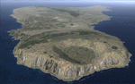
This project rebuilds Easter Island / Isla de Pascua. Mataveri Intl (SCIP) is completely overhauled, and all airport objects are aligned from satellite imagery. Landclass polygons and coastlines were meticulously hand-drawn directly from satellite imagery to provide the most detailed and accurate scenery available for this region. AI road and boat traffic is activated for the region. Accurate coastlines and road data, as well as corrected land and waterclass are provided based on the latest available satellite imagery. GA flights use default aircraft and include an option to add Chilean Air Force planes around the island. Numerous Moai (Easter Island heads) have been placed around the island according to satellite imagery. Scenery was created using Airport Design Editor X v1.61.5298, SBuilderX 3.13, and the FSX Object Placement Tool. Scenery objects were added and modified from stock FSX scenery to resemble as closely as possible the actual airports. The FSX apron lights included are from the terrific set created by Jim Dhaenens.
| Filename: | SCIP__Isla_de_Pascua__Mataveri_Intl___Easter_Islan.zip |
| License: | Freeware |
| Added: | 12th July 2014, 08:17:55 |
| Downloads: | 5,715 |
| Author: | Carlyle Sharpe |
| Size: | 5.33 MB |
© 2001-2026 AVSIM Online
All Rights Reserved
Privacy Policy |