
Where Flight Simulation Enthusiasts Gather from Around the World!
AVSIM Library - Search Results

| Category: Flight Simulator 2004 - Scenery | |
| Alabama Airport Trio |

|
File Description:
This is some airport enhancements I did for KHSV (Huntsville Intl.) KMOB (Mobile Regional) and KBHM (Birmingham Internations) way back in 2004. I was out of Flight Simming for quite a while and just recently read about the AVSIM hack and had wondered why a whole mess of files were missing.
The enhancements were done in Nov 2004 and have not been modified in any way since their creation. Life goes on, so they may not fully represent current condtions at these three airports. (I know some gates were removed from HSV for it's (food court) so be that as it may.
Well, here you are, my small contribution to the Flight Simulator community. It pales in comparison to what others have offered, but it still is the only "enhancements" that have ever been done for these three airports I believe.
| Filename: | Alabama_Airport_Trio.zip |
| License: | Freeware, limited distribution |
| Added: | 9th July 2012, 08:27:46 |
| Downloads: | 484 |
| Author: | William H Thomas |
| Size: | 796.05 KB |
| Category: Flight Simulator X - Panels | |
| Alphasim F-111 Panel Package Version 2.0 |
|
Images related to this file:
File Description:
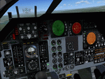
This upgrade to the Alphasim F-111 adds a Weapons System Operator Panel with default and old avionics packages, Working TERRAIN FOLLOWING RADAR scope
shows accurate ground mapping ahead of aircraft in 5, 10 or 15 mile ranges, THREAT WARNING DISPLAY shows airborne AI aircraft in 20 or 40 mile ranges, Ground Attack RADAR displays airports and AI aircraft on default panel and airports as ground targets in ranges of 5,10,30,80 and 200 miles on old avionics panel, Shockwave Lights ready, Updated afterburner effects, INS (old avionics panel) displays working digital readout of latitude, longitude, and altitude, TFR and TWR gauges automatically change brightness between day and night to match lighting conditions.New Autopilot and Lighting control panels. Features custom gauges created by Dietmar Loleit for this project. You must have the Alphasim F-111 aircraft package for this panel
| Filename: | Alphasim_F111_Panel_Package_Version_20.zip |
| License: | Freeware |
| Added: | 7th November 2009, 12:11:41 |
| Downloads: | 917 |
| Author: | Steve Hess |
| Size: | 15.88 MB |
| Category: Flight Simulator 2004 - Utilities | |
| AI FlightPlan Utilities Version 1.5.4 |
|
File Description:
The AI FlightPlan Utilities package consists of a group of four utilities that enable the user to easily edit the text files (Aircraft, Airports and FlightPlans) used by Lee Swordy�s TTools 2004 program to create AI FlightPans for Flight Simulator 2004. The utilities include an AI Airport editor that allows users to add Airport data to a new or existing TTools Airport text file, an AI Aircraft editor that automates the process of adding AI aircraft to the Aircraft text files, an Aircraft and Panel editor that makes it a little easier to edit Aircraft.cfg and Panel.cfg files and a utility to create a new set of FlightPlan text files (Aircraft, Airports and FlightPlans) for use by TTools. The AI FlightPlan Utilities package is a companion utility to the AI FlightPlan Creator (AIFC174.zip) available here at Avsim.
| Filename: | AI_FlightPlan_Utilities_Version_154.zip |
| License: | Freeware, limited distribution |
| Added: | 19th March 2007, 19:45:40 |
| Downloads: | 11,139 |
| Author: | Dave Westbury |
| Size: | 1.57 MB |
| Category: Miscellaneous Files - General Utilities | |
| Wx2pfpx v2.6.4 |
|
Images related to this file:
File Description:
A simple weather data provider for the discontinued Professional Flight Plan X software. The script fetches raw weather data, METAR and TAF data from the NOAA, US national weather service, which is then compiled to a single file that can be imported in PFPX. More than 15000 reference stations (airports) from PFPX are used and wind/temperature data is provided for each of them. When available, METAR and TAF data is also provided for more than 5000 airports. The original data source is updated 4 times a day, and can provide forecasts for every 3 following hours up to 16 days. *** A new script can trigger antivirus analysis as it's unknown, you can ignore it.*** V2: Great precision improvement, possibility of importing the whole NOAA dataset grid, a bit of documentation. V2.6: Repaired due to API change.
| Filename: | Wx2pfpx_v264.zip |
| License: | Freeware, limited distribution |
| Added: | 27th September 2025, 15:55:08 |
| Downloads: | 84 |
| Author: | John Smith |
| Size: | 21.97 MB |
| Category: Navigation and ATC - Navigation | |
| LSZS - Samedan visual approach chart v3 |
|
Images related to this file:
File Description:
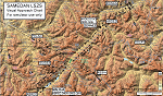
Custom made visual approach chart and pilot's briefing for Engadin (St. Moritz) Samedan LSZS airport in Switzerland, Europe's highest elevation airport (5,600 ft.) situated in the Swiss Alps. This airport is a day VFR operations only and has no instrument approach due to extreme terrain around it. A demanding visual descent into a canyon, in between steep rising terrain, is required to make the visual approaches for both runways with a steep 4.4* degrees final approach portion guided by the PAPI's. Still, executive jets up to Boeing 737(BBJ) size approach the airport often in the winter peak season VFR with these procedures. It is designed as per real operators' pilot briefing for Samedan. Real airport's full pilot briefing document also included. The real airport's excellent briefing (included) intentionally does not contain the maneuvers needed for the approach of jets through the mountains but only reporting points for all and maneuvers for light aircraft only. This gap is what this chart covers. Version 2 chart included better graphics and refined visual procedure for jets and version 3 now includes real pilot's briefing guide.
| Filename: | LSZS__Samedan_visual_approach_chart_v3.zip |
| License: | Freeware, limited distribution |
| Added: | 20th March 2015, 23:35:11 |
| Downloads: | 2,026 |
| Author: | Kyprianos Biris |
| Size: | 7.1 MB |
| Category: Flight Simulator X - Scenery | |
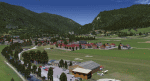
| LOSM Mauterndorf, Austria Version1 for FSX and P3D_v3/v4 |
|
Images related to this file:
File Description: The Airfield Mauterndorf is the highest situated airfield in Austria: 3642 ft or 1110 meters above sealevel.
This Airfield is very common for glider flyers due to the usually good upwinds for flying in the alps. But also small engine aircrafts are approved. Link:
http://www.losm.at/index.php/losm.html The environment of the airfield is adapted by landclasses. Mauterndorf and the surrounding villages, valleys and major roads are included.
As well the field is covered by a photo background, wich includes four different images , each for one of the four seasons spring, summer, autum and winter. The buildings in this scenery are designed mainly new by myself, but also a lot of objects from two very popular freeware libraries.
If these libraries are not installed, many objects are not visible! The following libraries are used: 1. FS-Piloten_Objektlibrary:
http://www.fs-piloten.de/thread.php?threadid=10632 2.FSX_FlightPortLib:
http://www.flightport.de/libraries/flightport-library/ This senery works also with Austria Professional HD.
| Filename: | LOSM_Mauterndorf_Austria_Version1_for_FSX_and_P3D_.zip |
| License: | Freeware |
| Added: | 28th August 2017, 20:01:00 |
| Downloads: | 477 |
| Author: | Wolfgang Allers |
| Size: | 249.9 MB |
| Category: Flight Simulator X - Aircraft Repaints, Textures and Modifications | |
| Institut Geographique National, Boeing B-17G Flying Fortress (F-BGSP) |
|
Images related to this file:
File Description:
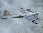
This folder contains a repaint for the accu-sim version of the A2A B-17G Flying Fortress. #44-8846 was originally allocated to the 351st BG in Polebrook, but was bought by the French Insitut Geograpique National (IGN) for aerial survey work, flying as F-BGSP. It flew for a while in South Africa too, but came back to France as F-AZDX and flew with the Forteress Toujours Volante society until early 2010, most recently as 22960 'Pink Lady'.
Repaint by Jan Kees Blom, based on the repaint kit by A2A.
| Filename: | Institut_Geographique_National_Boeing_B17G_Flying_.zip |
| License: | Freeware |
| Added: | 29th June 2010, 18:29:57 |
| Downloads: | 376 |
| Author: | Jan Kees Blom |
| Size: | 19.61 MB |
| Category: Flight Simulator 2004 - Sounds | |
| Transavia France Callsign FRANCE SOLEIL |
|
Images related to this file:
File Description:

FS2004/FSX EditVoicepack Callsign file for Transavia France, TVF/TO, France. This callsign uses the French pronunciation of France Soleil. This is part of our 1st round of EditVoicepack files (see aig_tower_release_1.zip). Our goal is to provide accurate ATC calls in order to provide Microsoft Flight Simulator traffic with quality ATC. These sounds are the best that we have been able to compile and are accurate as of release date and to the extent that our data and the limitations of the EditVoicepack allow. Visit us at www.alpha-india.net for more information.
| Filename: | Transavia_France_Callsign_FRANCE_SOLEIL.zip |
| License: | Freeware, limited distribution |
| Added: | 4th December 2010, 14:46:27 |
| Downloads: | 873 |
| Author: | Bruce Nicholson & Alpha India Group |
| Size: | 2.51 KB |
| Category: Flight Simulator 2004 - Aircraft Repaints, Textures and Modifications | |
| Alpha 2160 ZK-WKF |
|
File Description:
Repaint of ZK-WKF, an Alpha-2160 built in Hamilton New Zealand for the Waikato Aero Club. Alpha Aviation have since gone into liquidation which is a shame but as far as I know this aircraft is still used by the club. The aircraft itself is a variation of the original French designed Robin HR200 which is what this repaint is based on for the simulator. The model required for this repaint is by Mike Stone and can be found here at AVSim. The filename is "shr200.zip"
| Filename: | Alpha_2160_ZKWKF.zip |
| License: | Freeware |
| Added: | 30th December 2008, 10:58:49 |
| Downloads: | 229 |
| Author: | Dean Stringer |
| Size: | 542.28 KB |
| Category: Flight Simulator 2004 - Aircraft Repaints, Textures and Modifications | |
| Piper L-18C Fench Army PA 13eme DI 1958 |
|
File Description:
This is a repaint based on Aerosoft’s payware Piper Super Cub V1.20.The French Army Aviation (ALAT) received under MDAP a total of 352 Piper L-18Cs, most of them being used in Algeria. This machine is shown in the markings of PA 13eme DI during 1958 whilst based in Sidi-bel-Abbes; it sports an olive drab finish with white upper wing recognition stripes. The fuselage roundel, which proved to be an easy target to aim at for rebels, has not yet been deleted. Repaint by Michel Gerard.
| Filename: | Piper_L18C_Fench_Army_PA_13eme_DI_1958.zip |
| License: | Freeware |
| Added: | 22nd December 2008, 22:52:47 |
| Downloads: | 157 |
| Author: | Michel Gerard |
| Size: | 1.51 MB |
© 2001-2026 AVSIM Online
All Rights Reserved
Privacy Policy |