
Where Flight Simulation Enthusiasts Gather from Around the World!
AVSIM Library - Search Results

| Category: Flight Simulator 2004 - Scenery | |
| Unalakleet PAUN modification in Alaska |

|
Images related to this file:
File Description:
This version of Unalakleet PAUN is a modification of the scenery made by Sid and Pete way back in 2011, posted with Sid's knowledge and ok. There is a dearth of photographic information available on PAUN and it was only recently that there was enough so that hangars could be properly made and also properly situated. Which is why I made this now with a new ERA hangar, a new beige hangar rotated 90 degrees, next to it a blue hangar, plus fuel tanks, signage, and updated AI to include ERA planes, a NAC B737 and a NAC DC6B. Unalakleet has a population approaching 700, and lives by the income earned from the harvest from the sea and the river. There is no road within hundreds of miles and the only way to get food or anything else delivered is by ship (but only in the ice-free summer months) or through the airport.
| Filename: | Unalakleet_PAUN_modification_in_Alaska.zip |
| License: | Freeware, limited distribution |
| Added: | 24th July 2019, 18:55:37 |
| Downloads: | 245 |
| Author: | Roger Wensley |
| Size: | 3.94 MB |
| Category: Microsoft Flight Simulator (2020) - Aircraft Repaints, Textures and Modifications | |
| Grumman Goose (N2751A) Alaska Airlines |
|
Images related to this file:
File Description:
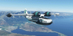
This folder contains a repaint for the Grumman Goose for MSFS2020, available at sim-outhouse.com, in the colors of Grumman Goose c/n 1184 N2751A, built in 1942, in the colors of Alaska Airlines, 1972. Repaint by Jan Kees Blom, based on the paintkit by the OZx team.
| Filename: | Grumman_Goose_N2751A_Alaska_Airlines.zip |
| License: | Freeware |
| Added: | 2nd January 2021, 18:49:43 |
| Downloads: | 84 |
| Author: | Jan Kees Blom |
| Size: | 53.66 MB |
| Category: Flight Simulator 2004 - Scenery | |
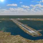
| Homer PaHO in Alaska US |
|
Images related to this file:
File Description:
Homer is a mainly GA airfield with rows of open air parking, but it also has scheduled flights, a terminal building, a long (for GA) runway of just under 6,700 feet that is 150 feet wide and aligned 03-21 with VASI on both ends and ILS on 03. So I think we can refer to it as an airport. Plus, at the time of this scenery (around 2010) there were three newly completed hangars on the north apron that I was told were for three companies, Bald Mountain Air service, Maritime Helicopters, and Pathfinder Aviation. I do not know which was for whom, but all three companies are in the helicopter and/or plane charter business. The south apron has a number of hangars and other buildings along it's length, starting at the western end with Smokey Bay Air that has an old control tower on the roof, then the Fire Station, and then Homer Air. I am not aware of who owns what after those first three, except that at the far eastern end there are several garages etc for the airport maintenance equipment. Next to the airport at that end there are a number of boat maintenance companies with boats pulled out of the water; this could not be well replicated due to the airport elevation above the sea level and a misplaced road. The nearby Beluga Lake 5BL float base is also included here, with some AI. The lake height above sea level has been adjusted to cope with too many cliffs intruding into the water; this is an annoying FS9 habit. The Homer scenery is as close to the actual airport as I could make it, while coping with inaccurate coast lines and roads, and grassed areas that could not all be modified for reasons that I will not bore you with. The Spit is a major scenery feature next to the airport, and I have added to this to provide some boats, docks, and nearby buildings etc. Small planes use the adjacent gravel taxi path instead of the runway when back-tracking to take off on runway 21. They only go as far as the path takes them and then u-turn onto the runway and take off. By the way, this airport's AI will function at its best if the prevailing wind makes 03 the runway in use. And I will eventually stop writing 03 and just call it 3, as the US, alone in the world, does not put a zero in front of 01, 02, 03, 04 etc. Just one other thing to note is that all access to the runway is from taxiways A and B; there was (in 2010) no access to the extreme western end of the runway as the taxiway there is marked as out of service pending a needed resurfacing.
If you find an error email me please, and note that my email address has been changed to rogwens at Gmail dot com.
| Filename: | Homer_PaHO_in_Alaska_US.zip |
| License: | Freeware, limited distribution |
| Added: | 28th July 2021, 03:31:04 |
| Downloads: | 125 |
| Author: | Roger Wensley |
| Size: | 11.86 MB |
| Category: Flight Simulator X - AFCAD Files | |
| PAOT - Wien Meml - Kotzebue, Alaska |
|
Images related to this file:
File Description:
This AFCAD of the airport Wien Meml - Kotzebue (PAOT), Alaska, fixes some issues for Scenery Solution's UTX Alaska users who want to use mesh and texture resolutions better than 38 m and 1 m, respectively. Unfortunately this discloses some additional problems with lagoons surrounding runway 09/27. Some of the ponds had been elevated over apron level, the fence Microsoft had drawn around the airport ran through (elevated) water and so on. Runway 27 has no direct connection to the mainland like it is realized by UTX and furthermore a lot of water polygons (including the lagoons) had 'forgotten' shore line vectors. Included corrections are: fixed main waterpolygons around the airport (according to Google Maps), fixed airport layout, including aprons, GA parking, additional airport buildings (default FSX objects), fixed Runway designators (now 09/27 resp. 18/36 instead of 08/26 and 17/37, Nov. 2013), added shoreline vectors (compatible to UTX textures) and some more.
Again, THIS AFCAD IS INTENDED FOR USERS OF UTX ALASKA ONLY and will likely look horrible in other environments as it partially amends missing features only.
| Filename: | PAOT__Wien_Meml__Kotzebue_Alaska.zip |
| License: | Freeware, limited distribution |
| Added: | 3rd February 2014, 14:30:10 |
| Downloads: | 409 |
| Author: | Axel Birsul |
| Size: | 1.09 MB |
| Category: Flight Simulator X - AFCAD Files | |
| PAAK - Atka Airport - Alaska, USA |
|
File Description:
Atka Airport (IATA: AKB, ICAO: PAAK, FAA LID: AKA, formerly 40A) is a state owned, public use airport located two nautical miles (4 km) north of the central business district of Atka, a city on Atka Island. Scheduled commercial airline passenger service is subsidized by the Essential Air Service program.
Changes are based on 2007 construction plans. Length of Runway `6/34 was increased to 5,000 feet and width to 100 feet.Moved and increased size of parking area.REIL lights placed.
| Filename: | PAAK__Atka_Airport__Alaska_USA.zip |
| License: | Freeware |
| Added: | 8th October 2013, 19:27:28 |
| Downloads: | 264 |
| Author: | Wayne Roberts |
| Size: | 3.95 KB |
| Category: Flight Simulator 2004 - Scenery | |
| PAWS - Wasilla - Anchorage, Alaska - USA |
|
Images related to this file:
File Description:
Wasilla PAWS is in Alaska, some 27 miles northeast of Anchorage and 11 miles due north of Birchwood, on the northern side of the Knik Arm. It is, like Birchwood, a small version of Merrill Field for mostly GA aircraft and private hangars, with some maintenance shops. The town of Wasilla is shown in FS9 and is quite large. There are a bunch of private airfields within a ten mile radius and some of these will be posted in this series, as will some other larger airfields. The main runway is around 3,700 feet long, aligned 03-21 and asphalted and lit, as are the taxiways. Again, like Birchwood, there is also a shorter and parallel runway that is grass and which receives no winter maintenance, for winter use by planes that are on skis.
| Filename: | PAWS__Wasilla__Anchorage_Alaska__USA.zip |
| License: | Freeware, limited distribution |
| Added: | 13th October 2014, 15:04:08 |
| Downloads: | 318 |
| Author: | Roger Wensley |
| Size: | 18.73 MB |
| Category: Flight Simulator 2004 - Scenery | |
| Graham Field in Anchorage, Alaska |
|
File Description:
This scenery is located in Anchorage Alaska. All default enhanced.
Airport name,
1.Graham field(48AK). 2 Aircraft doing touch and go's around the field. will start at 22:00GMT.
Aircraft involved: Vega5c. call sign 41 bravo charlie. Vega5b. call sign 10 bravo delta.
| Filename: | Graham_Field_in_Anchorage_Alaska.zip |
| License: | Freeware |
| Added: | 24th January 2004, 23:43:02 |
| Downloads: | 2,253 |
| Author: | Frank Betts |
| Size: | 1.28 MB |
| Category: Flight Simulator X - AFCAD Files | |
| PANI - Aniak Airport | Aniak, Alaska |
|
File Description:
PANI - Aniak Airport | Aniak, Alaska. The amount of parking, as well as AI-Traffic handling efficiency is now double what it was before at this airport. Day & Night visual effects and performance have also been considerably enhanced. This was designed using Flight 1's excellent "Airport Facilitator X" program.
| Filename: | PANI__Aniak_Airport_____Aniak_Alaska.zip |
| License: | Freeware |
| Added: | 5th January 2009, 13:02:22 |
| Downloads: | 592 |
| Author: | Dakota Smith / Smith Graphics |
| Size: | 86.68 KB |
| Category: Flight Simulator X - AFCAD Files | |
| PAEM - Emmonak Airport | Emmonak, Alaska |
|
File Description:
PAEM - Emmonak Airport | Emmonak, Alaska. The amount of parking, as well as AI-Traffic handling efficiency is now double what it was before at this airport. Day & Night visual effects and performance have also been considerably enhanced. This was designed using Flight 1's excellent "Airport Facilitator X" program.
| Filename: | PAEM__Emmonak_Airport_____Emmonak_Alaska.zip |
| License: | Freeware |
| Added: | 5th January 2009, 13:03:32 |
| Downloads: | 648 |
| Author: | Dakota Smith / Smith Graphics |
| Size: | 85.37 KB |
| Category: Flight Simulator 2004 - Scenery | |
| PAMR - Merrill Field - Anchorage, Alaska |
|
Images related to this file:
File Description:
Merrill Field is in Anchorage Alaska, between Anchorage International to the southwest and and Elmendorf Air Force Base to the north. It caters for general aviation and is the land equivalent of the Lake Hood float plane base (see my post) with fuel and numerous maintenance facilities, and several hundred parking spots for small planes. There are three runways, and the longest is 4,000 feet of 100 feet wide asphalt, the second 2,635 feet of asphalt 75 feet wide, and the third 2,000 feet of 60 feet wide gravel. It is a controlled airfield with a modern control tower. There are almost 50 buildings on the field and three quarters of them have been modeled specifically for this scenery. The download includes a LITE version for older computers as there are a lot of static parked aircraft.
| Filename: | PAMR__Merrill_Field__Anchorage_Alaska.zip |
| License: | Freeware, limited distribution |
| Added: | 3rd January 2011, 23:11:31 |
| Downloads: | 1,122 |
| Author: | Roger Wensley |
| Size: | 6.94 MB |
© 2001-2026 AVSIM Online
All Rights Reserved
Privacy Policy |