
Where Flight Simulation Enthusiasts Gather from Around the World!
AVSIM Library - Search Results

| Category: Flight Simulator 2004 - AI Aircraft | |
| Era Alaska Cessna 207 |

|
Images related to this file:
File Description:
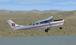
Repaint of the payware Henry Tomkiewicz AI (HTAI) Cessna 207 in Era Alaska colours. Textures only, you must own have the HTAI payware package for this texture. Includes FSX friendly prop texture.
| Filename: | Era_Alaska_Cessna_207.zip |
| License: | Freeware |
| Added: | 26th September 2011, 14:37:29 |
| Downloads: | 461 |
| Author: | Chris Peschke, HTAI |
| Size: | 287.97 KB |
| Category: Flight Simulator X - Aircraft Repaints, Textures and Modifications | |
| Era Alaska Bell 222b |
|
Images related to this file:
File Description:
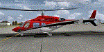
Era Alaska has several helicopter liveries, but the Bell 222b is not one of them. This is a fictional livery using one of their real world Era helicopter registration number. These textures are to be used with the Cera Simaircraft Bell 222b payware.
| Filename: | Era_Alaska_Bell_222b.zip |
| License: | Freeware |
| Added: | 27th September 2011, 01:46:03 |
| Downloads: | 344 |
| Author: | Johnny Rosario |
| Size: | 13.08 MB |
| Category: Flight Simulator 2004 - Scenery | |
| Bettles PABT in Alaska |
|
Images related to this file:
File Description:
Bettles is around 175 miles north of Fairbanks in ALaska, and 25 miles north of the Arctic Circle. It is also where James "Andy" Andersen started flying for Wien Airlines and where he spent the 20 years between 1947 and 1967. Read "Arctic Bush Pilot" by Andy and Jim Rearden for his story of those 20 years flying the bush. Bettles PABT is the gravel strip and due to the limitations of FS9 AI the float base on the adjacent river has to be separately named PABX. Bettles village (old Bettles) used to be 2 miles southwest of the field, but has now slowly relocated close to the strip. In this download there is an AFCAD folder, landclass folders, a scenery folder, and a traffic folder. You will need Ultimate Terrain Alaska Canada.
| Filename: | Bettles_PABT_in_Alaska.zip |
| License: | Freeware, limited distribution |
| Added: | 22nd August 2010, 16:21:12 |
| Downloads: | 755 |
| Author: | Roger Wensley |
| Size: | 2.66 MB |
| Category: Flight Simulator 2004 - AI Flight Plans | |
| Alaska Airlines Summer 2010 |
|
Images related to this file:
File Description:

This is part of our 8th round of flightplans for the Summer 2010 season. The team aims to provide high quality flightplans for the FS community. Each flightplan has been tested using many resources, and our goal is to make a realistic representation of each airline's route network. Visit us at www.alpha-india.net for more information.
| Filename: | Alaska_Airlines_Summer_2010.zip |
| License: | Freeware, limited distribution |
| Added: | 30th August 2010, 18:25:51 |
| Downloads: | 1,826 |
| Author: | Philippe Plein & Alpha India Group |
| Size: | 65.13 KB |
| Category: Flight Simulator X - AFCAD Files | |
| GNV - Goodnews Airport, Alaska |
|
File Description:
Goodnews Airport (IATA: GNU, FAA LID: GNU) is a state-owned public-use airport located at Goodnews Bay in the Bethel Area of the state of Alaska.
All changes made were based on 2006 construction plans.
Increased runway length to 3,300 ft., added runway threshold (REIL) lights moved and increased apron parking area and added custom buildings.
| Filename: | GNV__Goodnews_Airport_Alaska.zip |
| License: | Freeware |
| Added: | 7th March 2013, 02:00:38 |
| Downloads: | 640 |
| Author: | Wayne Roberts |
| Size: | 602.72 KB |
| Category: Flight Simulator X - AFCAD Files | |
| 4A2 - Atmautliak Airport, Alaska |
|
File Description:
Atmautluak Airport is a state-owned public-use airport located in Atmautluak, in the Bethel Census Area of the U.S. state of Alaska.
Atmautluak Airport has one runway designated 15/33 with a 3,000 by 75 ft (914 x 23 m) gravel surface. The runway was previously 2,000 by 30 ft. until it was expanded by the state.
All changes made were based on 2006 construction plans. Changed runway to 75 ft. wide.Added aprons, additional parking and buildings.
| Filename: | 4A2__Atmautliak_Airport_Alaska.zip |
| License: | Freeware |
| Added: | 28th December 2012, 00:44:08 |
| Downloads: | 332 |
| Author: | Wayne Roberts |
| Size: | 2.86 KB |
| Category: Flight Simulator X - AFCAD Files | |
| PADU - Unalaska Airport, Alaska |
|
File Description:
The airport is sometimes referred to as Dutch Harbor Airport. In 2002, the State of Alaska renamed it Tom Madsen Airport in honor of Charles Thomas Madsen Sr., a bush pilot who was killed in an airplane accident that year. However, the Federal Aviation Administration still refers to it as Unalaska Airport.
Moved aprons, added additional parking and buildings. Adjusted and added taxiway lights. Changes are based on 2012 construction plans.
| Filename: | PADU__Unalaska_Airport_Alaska.zip |
| License: | Freeware |
| Added: | 3rd January 2013, 01:53:15 |
| Downloads: | 873 |
| Author: | Wayne Roberts |
| Size: | 136.52 KB |
| Category: Flight Simulator X - AFCAD Files | |
| PAMC - McGrath Airport - Alaska |
|
Images related to this file:
File Description:
McGrath Airport covers an area of 641 acres (259 ha) at an elevation of 343 feet (105 m) above mean sea level. It has two asphalt paved runways: 16/34 measuring 5,936 x 100 ft (1,809 x 30 m) and 23/05 measuring 2,000 x 60 ft.
Changes were made based on 2012 construction plans. Runway 23/05 was added along with taxiway "C" and parking aprons.
| Filename: | PAMC__McGrath_Airport__Alaska.zip |
| License: | Freeware |
| Added: | 16th August 2013, 06:54:41 |
| Downloads: | 300 |
| Author: | Wayne Roberts |
| Size: | 9.23 KB |
| Category: Flight Simulator X - AFCAD Files | |
| WNA - Napakiak Airport - Alaska |
|
File Description:
Changes are based on 2002 construction plans. No custom models with this airport.
| Filename: | WNA__Napakiak_Airport__Alaska.zip |
| License: | Freeware |
| Added: | 22nd September 2013, 06:38:01 |
| Downloads: | 191 |
| Author: | Wayne Roberts |
| Size: | 3.49 KB |
| Category: Flight Simulator X - AFCAD Files | |
| PASD - Sand Point, Alaska |
|
Images related to this file:
File Description:
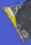
The airport of Sand Point (PASD) has been extended since Microsoft has modeled it and even after the upgrade through Scenery Solution's Ultimate Terrain X Alaska has been produced. This AFCAD is built on the UTX version of the airport and is intended to be used in this environment only.
The file considers the extended runway, VASI4 at both ends with 3.6 deg glideslope and the necessary new water-polygon. Due to the specific coastline bitmaps used by UTX I had to change to Microsoft's default ones being accessible through the wonderful tool Airport Design Editor X. Some additional landclass in the airport's vicinity and three (default) buildings close to the apron are completing the changes. I did not touch the easterly landing stage (or whatever it could have been) even if Google suggests that it disappeared meanwhile except some remaining piles in the water - it's just looking nice. ;-)
| Filename: | PASD__Sand_Point_Alaska.zip |
| License: | Freeware |
| Added: | 17th October 2013, 18:55:00 |
| Downloads: | 377 |
| Author: | Axel Birsul |
| Size: | 646.25 KB |


© 2001-2026 AVSIM Online
All Rights Reserved
Privacy Policy |