
Where Flight Simulation Enthusiasts Gather from Around the World!
AVSIM Library - Search Results

| Category: Flight Simulator X - Flight Plans | |
| Flying for Salmon-- Episode 2 of Canadian Mountain Flying (Last for the moment...we move down South Next!!) |

|
File Description:
As a bush pilot you have found the best "Smoked Salmon" of Canada. Up in the Western Mountains near the State of Washington. Not an easy area to fly in for bad weather and towering mountains are king. This niche is rather unique and not to many pilots take the risk of flying around here to get some Salmon
for Specialty Restaurants. Time to fly. You have been fixing some turbine problems all day but now at 4:15 PM you are ready to go. Weather is not too good so be careful. Warning: This flight is for really good Bush Pilots, if you need ATC and Landing aids you better take the last flight to Seattle that
leaves in about an hour...PS: We move on to the South after this flight, so you might as well do it and keep some Salmon for yourself!!!
| Filename: | Flying_for_Salmon_Episode_2_of_Canadian_Mountain_F.zip |
| License: | Freeware, limited distribution |
| Added: | 1st September 2008, 21:03:42 |
| Downloads: | 809 |
| Author: | Gera Godoy Canova |
| Size: | 1.06 MB |
| Category: Flight Simulator X - AFCAD Files | |
| FSX "Mach Loop Tower Cameras" Addon Scenery Package |
|
Images related to this file:
File Description:
FSX "Mach Loop Tower Cameras" Addon Scenery Package.
Mach Loop fans Rejoice! I have created 7 independent "Tower Cameras" located around the Loop, including the ones famous on Youtube! I've spaced them so you can set your "Tower View" to "Nearest Tower" the view will transfer seamlessly from camera to camera as you fly all the way around!!! Strap into your Typhoon, Tornado, or Strike Eagle and experience it for yourself...GUARANTEED to make so smile! ;)
Installation is easy...Just copy all seven "EGMx_ADEX_DWG" files to your "FSX/Addon Scenery/Scenery" file.
(*note; they start at "EGM2" because EGM1 didn't "make the cut")
Thanks everyone for the YouTube vids! Now YOU get to fly and film the Mach Loop in FSX!
Tower Cams created using ADE "Aiport Design Editor".
OrbX Scenery and Dino Cattaneo's "Eurofighter 2000" shown in pics.
500ft at 500kts!
Daniel Gregory
[email protected]
| Filename: | FSX_Mach_Loop_Tower_Cameras_Addon_Scenery_Package.zip |
| License: | Freeware |
| Added: | 28th December 2020, 03:11:13 |
| Downloads: | 180 |
| Author: | Daniel Gregory |
| Size: | 2.7 MB |
| Category: Flight Simulator X - Aircraft Repaints, Textures and Modifications | |
| Aerosoft F-16 "Viper" Performance Tune Up and Handling Upgrade |
|
Images related to this file:
File Description:
Aerosoft F-16 "Viper" Performance Tune Up and Handling Upgrade
If you're a fan of the F-16, than this "Viper Upgrade" will make you SMILE with 9g's of JOY!
I have "modified/tuned-up" the AIR and CFG files so the jet is now "airshow precise". The slow-roll, the 8 Point Roll, 9g sustained turns, and MUCH, MUCH, MORE! Basically, everything an F-16 can REALLY do, your Aerosoft F-16 will now be able to do.
Pick your favorite F-16 YouTube airshow vid from ANY AIR FORCE in the WORLD and fly along! Or, if you prefer, zoom thru the Mach Loop or Star Wars Canyon at 500ft and 500kts with fly-by-wire PRECISION!
Plus, if you want to get silly, you can CRANK UP the "ELEVATOR EFFECTIVENESS" to 2.60 and try BOTH the Cobra and Backflip!! Many smiles await!
| Filename: | Aerosoft_F16_Viper_Performance_Tune_Up_and_Handlin.zip |
| License: | Freeware |
| Added: | 15th December 2020, 03:33:50 |
| Downloads: | 230 |
| Author: | Daniel Gregory |
| Size: | 327.98 KB |
| Category: Flight Simulator 2004 - Aircraft Repaints, Textures and Modifications | |
| ELVA / FlyUK Boeing 737 Package Update to v3 |
|
Images related to this file:
File Description:
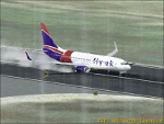
FS2004 ELVA B737 Pack Update to v3. This file will upgrade my ELVA Boeing 737 Pack to version 3. Version 3 includes some major and minor updates. It also adds new features: Heat Haze (shimmer) effects plus smoke effects by Martyn Becker, Reverser Spray Effects by Edward Cox and Takeoff Spray effects by Dennis Franke. Fly UK Virtual Airways liveries are also included for Fly UK members to use as well. I have also created a low spec system option so that low spec users can use my boeing packages but with less features. See the readme file for more details. Patch by Peter Slater, uploaded by Gareth Abbott. Big thanks to those named here. Credited as asked. Visit his web site for his other projects at http://fsprojects.webs.com or search 'peter slater' here on AVSIM. You can watch a promo video at http://www.youtube.com/watch?v=2iIpb89yoO8, requires psb737f.zip
| Filename: | ELVA__FlyUK_Boeing_737_Package_Update_to_v3.zip |
| License: | Freeware |
| Added: | 16th January 2012, 04:13:23 |
| Downloads: | 3,027 |
| Author: | Peter Slater, Gareth Abbott |
| Size: | 16.03 MB |
| Category: Flight Simulator 2004 - Scenery | |
| Nimpo Lake CAF8 in British Columbia, Canada |
|
Images related to this file:
File Description:
Nimpo Lake is less than 10 miles south of Anahim Lake, and is a centre for fishing lodges and other "nature" activities such as hiking and hunting etc. As a result there is considerable float plane activity on the lake as clients are flown in, or out, to other lakes that are nearby, or just on sightseeing jaunts. This is the first of a trio of Nimpo Lake float bases, the "official" one that is in the Nav Canada floats listing as CAF8. It is close to the Wilderness Lodge fishing centre, included in this posting. Also included here are the AI Beavers that formed part of the Alaska payware scenery by FSAddon, with kind permission to use them for free scenery postings.
| Filename: | Nimpo_Lake_CAF8_in_British_Columbia_Canada.zip |
| License: | Freeware, limited distribution |
| Added: | 2nd December 2018, 17:17:43 |
| Downloads: | 107 |
| Author: | Roger Wensley |
| Size: | 14.86 MB |
| Category: Flight Simulator 2004 - AI Flight Plans | |
| Transmile Air Service - Winter 2006 |
|
File Description:
Winter 2006 flight plans for Transmile Air Services for use with Flight Simulator 2002 or 2004 AI traffic. They are based on the timetable at the company's web site and other sources. Transmile operate daily cargo services to various locations in Asia and long-distance services to Los Angeles via Hong Kong, which also make a technical stop at Anchorage, Alaska. The fleet consists of Boeing 727-200 and Douglas MD11 aircraft.
This file corrects a number of errors in previously released flight plans, see the readme.txt file within for details. You will need the Traffic Tools software by Lee Swordy to compile these plans for use with Flight Simulator.
[File re-uploaded at request of AVSIM]
| Filename: | Transmile_Air_Service__Winter_2006.zip |
| License: | Freeware |
| Added: | 29th May 2010, 09:33:22 |
| Downloads: | 918 |
| Author: | John Hinson |
| Size: | 2.83 KB |
| Category: Flight Simulator X - AFCAD Files | |
| Long Beach Municipal (KLGB) |
|
File Description:
Features:
- "spring street" flight schools and private terminal added.
- jetBlue, Horizen, Alaska,and other gates added from Google Earth positions.
- Vehicals, AI aircraft, grave yard aircraft, and many other static joys throughout the airport!
- "Runup" aircraft near runway 34R.
- Accurate roads including arrivals and departures
- Boeing C-17 facility (no aircraft C17 there)
- updated taxi ways and heliports
- Airport Service vehical roads updates and made with help from Google Earth.
- Accurated fence, jetblast fence, and boarders of airport.
- Cargo terminals added for UPS and DHL
- Private (gulfstream and other private) jet spots added.
- Flight Schools such as Long Beach Flight Academy (one I go to!!!) accurately made.
- New taxi ways and terrain
- MANY MANY More items you just need to see to believe!!!
| Filename: | Long_Beach_Municipal_KLGB.zip |
| License: | Freeware |
| Added: | 4th December 2011, 00:11:52 |
| Downloads: | 618 |
| Author: | Rohan Patel |
| Size: | 671.78 KB |
| Category: Flight Simulator 2004 - Aircraft Repaints, Textures and Modifications | |
| G-O Enterprises "Stage coach" Douglas DC-6A / C-118A (C-GPEG) |
|
Images related to this file:
File Description:
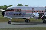
Textures for Tom Gibson's Douglas DC-6A/C-118 - repainted by Manfred Meyer.
You need to download and install the latest Douglas DC-6A CB-16 base pack with model, sound and panel from the website calclassic.com.
These textures depict C-GPEG (c/n 43576), flying cargo for Willy Laserichs G-O Enterprise from Yellowknife throughout Canada's northwest. Its a former USAF C-118A and has been around a bit as the flags of all at these times visited nations attest. After civilianisation a talented young lady from Tucson painted the "Stage coach" nose art on it and in 1978 W. Laserich bought the plane. Later on she went to Northern Air Cargo of Alaska as N99330 and lost her colorful markings.
| Filename: | GO_Enterprises_Stage_coach_Douglas_DC6A__C118A_CGP.zip |
| License: | Freeware |
| Added: | 8th September 2014, 14:04:21 |
| Downloads: | 143 |
| Author: | Manfred Meyer |
| Size: | 5.22 MB |
| Category: Flight Simulator X - Scenery | |
| LFLJ - Courchevel, France |
|
File Description:
This FSX scenery package contains the LFLJ Courchevel airport in the French Alps. The airport has a very short, upslope runway of only 525 m (1,722 ft). The airport is considered one of the seven most dangerous in the world. It has a difficult approach, a 300 foot upslope runway and is adjacent to the Courchevel ski runs. The Courchevel airport altitude is the highest in Europe, with a mean elevation of 6,520 feet. This airport is intended to be used with FSX and the free addon - TileProxy. TileProxy provides real-time photorealistic satellite imagery in place of the stock auto generated FSX scenery or any other scenery package. The Courchevel airport was originally released as part of an FSX airport scenery package containing 15 airports, located in the French Alps. The link to the original 15 French Alps Airport package is shown below. This file is not required, but allows you to download 15 related French Alps airports. The LFLJ, Courchevel airport in the original 15 airport package was missing a required scenery file which corrects the airport altitude (from 6420 ft. to 6520 ft.) due to the mis-location of the stock FSX airport. This download provides all three of the required .bgl scenery files.
related download:
http://library.avsim.net/search.php?SearchTerm=french+alps+airports&CatID=root&Go=Search
| Filename: | LFLJ__Courchevel_France.zip |
| License: | Freeware |
| Added: | 30th November 2013, 20:20:07 |
| Downloads: | 6,041 |
| Author: | John Greenwood |
| Size: | 655.63 KB |
| Category: Flight Simulator X - Scenery | |
| 52F North West Regional Airport (DFW TX) |
|
Images related to this file:
File Description:
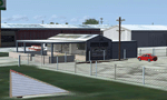
This airport scenery does not require any other software other than Microsoft Flight Sim X SP1 (minimum) - SP2 required for mission and display of some of the scenery items. However, it could help with performance on your PC if you install any accurate photo scenery for DFW. One such scenery is MEGASCENERY DFW photo scenery from http://www.megascenery.com/.
This is a custom developed scenery for airport, 52F - Northwest Regional, Roanoke, TX. 52F is next to Fort Worth Alliance in the Dallas Fort Worth Metroplex. It's a nice little airport.
This scenery package also includes a Mission called "52Foxtrot - Approach to Rwy 35 - Thermals". It is more of a free flight than the traditional FSX missions. The ones who fly for real at 52F-Northwest regional knows the quirks when coming into land at runway 35 on a hot day. The thermals at the cleared land and the sinking feeling when flying over the wooded area nearing the approach to 35. These thermal lifts and sinks have been modeled here. However, the only way to experience these thermals in FSX is via Missions. Once you select the mission "52Foxtrot - Approach to Rwy 35 - Thermals" and by selecting option "Enable changes in selected Mission", you could fly around like you would under "free flight". Except this time, you would have these thermal effects around 52F and get to experience what it's really like to fly and land at 52F.
| Filename: | 52F_North_West_Regional_Airport_DFW_TX.zip |
| License: | Freeware, limited distribution |
| Added: | 24th March 2010, 01:23:59 |
| Downloads: | 3,335 |
| Author: | Manny Mahadevan |
| Size: | 19.06 MB |


© 2001-2026 AVSIM Online
All Rights Reserved
Privacy Policy |