
Where Flight Simulation Enthusiasts Gather from Around the World!
AVSIM Library - Search Results

| Category: Flight Simulator 2004 - Aircraft Repaints, Textures and Modifications | |
| Alaska Airlines Bombardier CRJ-701 (N215AG) |

|
Images related to this file:
File Description:

I am proud to present this Bombardier CRJ-701 in the excellent Project Opensky CRJ-700 V3 model. This airframe, bearing registration N215AG, is the first of 3 Bombardier CRJ-700's to wear the Alaska Airlines' Smiling Eskimo livery. This is a detailed repaint with custom textures. All windows are custom, hand-painted, 3D with window shades. Night textures are custom (windows) as well. All repainted textures in this package are 32-bit with no mipmaps for best clarity and quality. This is a complete installation package; version 2008.1.1 of the Project Opensky CRJ-700 V3 model is included.
| Filename: | Alaska_Airlines_Bombardier_CRJ701_N215AG.zip |
| License: | Freeware, limited distribution |
| Added: | 7th June 2011, 01:30:43 |
| Downloads: | 979 |
| Author: | Jeffrey S. Bryner, Project Opensky / Freesky Project |
| Size: | 8.16 MB |
| Category: Flight Simulator X - Aircraft Repaints, Textures and Modifications | |
| ERA Alaska, DHC-6 Twin Otter |
|
Images related to this file:
File Description:
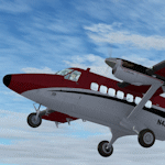
Repaint of the Aerosoft Twin Otter - Modern Version in ERA Alaska colors. It should work for other versions if you want it to but no garauntees, I did not test it in anything but the modern version. This is a fictional scheme created by me and not based on any real life schemes. You must have the Aerosoft Twin Otter Modern Version installed in your aircraft directory, these are texture files only. Basic installation instructions are included.
| Filename: | ERA_Alaska_DHC6_Twin_Otter.zip |
| License: | Freeware |
| Added: | 17th July 2011, 13:19:52 |
| Downloads: | 731 |
| Author: | Rick Bubier |
| Size: | 1.04 MB |
| Category: Flight Simulator X - Scenery Design | |
| PAFS - Nikolai Airport - Nikolai, Alaska, USA |
|
Images related to this file:
File Description:
Nikolai Airport (IATA: NIB, ICAO: PAFS, FAA LID: FSP) is a state-owned public-use airport located one nautical mile (1.85 km) northeast of the central business district of Nikolai, a city in the Yukon-Koyukuks Area.
Taxiway was changed along with aprom. Added custom buildings. Changes were made baded on 2001 construction plans. Created with Airport Design Editor by ScruffyDuck Software using current FAA documentation and Google Earth measurements, this package offers a replacement for FSX's stock airport. All these enhancements are as close to the real airport as I can get with stock library objects and custom buildings.
| Filename: | PAFS__Nikolai_Airport__Nikolai_Alaska_USA.zip |
| License: | Freeware |
| Added: | 26th February 2015, 18:03:39 |
| Downloads: | 607 |
| Author: | Wayne Roberts |
| Size: | 140.93 KB |
| Category: Flight Simulator 2004 - Aircraft Repaints, Textures and Modifications | |
| Alaska Airlines "Dreamliner" Boeing 737-800 |
|
Images related to this file:
File Description:

This Alaska Airlines "Dreamliner" includes: High quality fuselage textures, semi-photoreal windows, semi-photoreal night textures, dirt, customized shine effects, high quality wings textures, new winglet textures, new engines and much more. Model was made by Project OpenSky. Model and effects are included with this paint. Hope you enjoy! ;)
| Filename: | Alaska_Airlines_Dreamliner_Boeing_737800.zip |
| License: | Freeware |
| Added: | 22nd December 2010, 08:16:55 |
| Downloads: | 1,119 |
| Author: | Gabriel Parent-Nadon, POSKY |
| Size: | 9.59 MB |
| Category: Flight Simulator 2004 - Scenery | |
| Alaska North Slope 3: Atqasuk (PATQ) |
|
Images related to this file:
File Description:
The town of Barrow is in the far north of Alaska, and these are coastal villages or radar installations to the west and south of Barrow. There will be further additions. Atqasuk PATQ is 55 miles south of Barrow and is unusual in that it is one of the few settlements of the North Slope that is not on the coast. It is, however, on a narrow winding river that reaches the sea to the east of Barrow and seemingly provides fish in abundance. There could well be other good reasons for the village to be where it is, but they are unknown to me. The population is around 250. The airfield is to the south of the village and the runway is 4,900 feet of gravel aligned 06-24, lit, and with PAPI at each end.
| Filename: | Alaska_North_Slope_3_Atqasuk_PATQ.zip |
| License: | Freeware, limited distribution |
| Added: | 17th June 2016, 08:54:55 |
| Downloads: | 233 |
| Author: | Roger Wensley |
| Size: | 2.35 MB |
| Category: Flight Simulator 2004 - Scenery | |
| Alaska North Slope 5 - Nuiqsut PAQT |
|
Images related to this file:
File Description:
The town of Barrow is in the far north of Alaska, and these are coastal villages or radar installations to the west, south, and now east of Barrow. There will be further additions. Nuiqsut is a mainly Inuit community on the west side of the Colville River, around 20 miles south of the coast, and with a slowly declining population of around 420 or so. The airfield is just south of the town and has a gravel runway 5,000 feet long and aligned 04-22 in FS9. The airfield is the only year-round contact route to the rest of the world, though there are plans for a permanent road. The AI includes daily passenger flights early and late in the day, cargo deliveries, and some GA. It seems that the only photos I had of the airport were either of the old building or were not of Nuiqsut at all. The only pic I have seen (recently, which is why I now have doubts) of the new building is insufficient to model it, so I am sticking with the old or maybe incorrect version.
| Filename: | Alaska_North_Slope_5__Nuiqsut_PAQT.zip |
| License: | Freeware, limited distribution |
| Added: | 21st June 2016, 21:45:32 |
| Downloads: | 244 |
| Author: | Roger Wensley |
| Size: | 4.37 MB |
| Category: Flight Simulator 2004 - Scenery | |
| Alaska South Slope 12; Teller K54 |
|
Images related to this file:
File Description:
There are four main northwestern Alaska towns which are serviced by Alaska Airlines, and from which local flights spread out. The northernmost is Barrow. Southwest of Barrow is Kotzebue, then Nome, and the furthest south is Bethel (not yet made). This is the fifth in a series for local flights from Nome, and it is on the coast around 55 miles east of Wales and 55 miles northwest of Nome. There are two other airfields around a large lagoon that is almost totally enclosed from the sea, and Teller is on the easten shore, just 15 miles east of Port Clarence and 5 miles southeast of Brevig Mission, both already posted. Teller has a populaton of around 230, down from the 5,000 or so in the early 1900's after the Bluestone Placer Mine struck gold. Tollef Brevik was a Lutheran missionary who was both a pastor and teacher for the Inuit in the area from 1894 onward, travelling from community to community but based in Teller, where the Teller Mission Church was later renamed the Brevig Mission. The name was later appropriated and used for the curent village of that name; he was surely very well regarded by the local population. Unusually, it is possible to drive from Nome to Teller in summer, on a dirt road. Conversely, the road that shows in FS9 to the north towards Brevig Mission (courtesy of Ultimate Terrain) does not in fact exist except in winter, when it is estabished on the snow by the tyre tracks of users. The airstrip is southeast and 2 miles by road from the main part of the village on the spit, with a gravel runway 02-25 which is 3,500 feet of gravel. The AI is the usual for this area, Bering and ERA with some GA and cargo by Everts.
| Filename: | Alaska_South_Slope_12_Teller_K54.zip |
| License: | Freeware, limited distribution |
| Added: | 25th October 2016, 21:21:14 |
| Downloads: | 234 |
| Author: | Roger Wensley |
| Size: | 2.96 MB |
| Category: Flight Simulator 2004 - Scenery | |
| Alaska South Slope 5; Ambler PAFM |
|
Images related to this file:
File Description:
There are four main northwestern Alaska towns which are serviced by Alaska Airlines, and from which local flights spread out. The northernmost is Barrow. Southwest of Barrow is Kotzebue, then Nome, and the furthest south is Bethel (not yet made). This is a continuation of the series for the flights from Kotzebue, 130 miles to the east to Ambler on the bank of the Kobuk River. The next additions will be a few miles further east, Shungnak and Kobuk, and a small strip just to the north of Kobuk. Ambler is a small village (population now around 260) beside the Kobuk River, the river being the reason for the existance of the village as it served (and still does) as both a source of food and a transport route. The airfield is just north of the village, with two runways, each around 3,500 feet of lit gravel and aligned 36-18 and 09-27, with PAPI on 36. There are scheduled flights by Era (now renamed Ravn) and by Bering Air, both of them originating in Kotzebue and routing east to Ambler, Shungnak, Kobuk, and then back again. The AI includes these flights along with Everts Air and GA. There are revisions to Kotzbue to provide more parking.
| Filename: | Alaska_South_Slope_5_Ambler_PAFM.zip |
| License: | Freeware, limited distribution |
| Added: | 11th October 2016, 23:26:52 |
| Downloads: | 205 |
| Author: | Roger Wensley |
| Size: | 4.21 MB |
| Category: Flight Simulator 2004 - Scenery | |
| Alaska South Slope 6; Shungnak SHG |
|
Images related to this file:
File Description:
There are four main northwestern Alaska towns which are serviced by Alaska Airlines, and from which local flights spread out. The northernmost is Barrow. Southwest of Barrow is Kotzebue, then Nome, and the furthest south is Bethel (not yet made). This is a continuation of the series for the flights from Kotzebue, 150 miles to the east where Shungnak is on the bank of the Kobuk River. The next addition will be a few miles further east, Kobuk and a strip just to the north of Kobuk. Shungnak is a small village, like Ambler, with a population of around 260 beside the Kobuk River, the river being the reason for the existance of the villages as it served (and still does) as both a source of food and a transport route. The airfield is just beside the village, with a runway around 4,000 feet of lit gravel and aligned 09-27, with PAPI on both ends. There are scheduled flights by Era (now renamed Ravn) and by Bering Air, both of them originating in Kotzebue and routing east to Ambler, Shungnak, Kobuk, and then back again. The AI includes these flights along with Everts Air and GA.
| Filename: | Alaska_South_Slope_6_Shungnak_SHG.zip |
| License: | Freeware, limited distribution |
| Added: | 12th October 2016, 23:18:32 |
| Downloads: | 208 |
| Author: | Roger Wensley |
| Size: | 1.99 MB |
| Category: Flight Simulator 2004 - Scenery | |
| Alaska South Slope 4; Selawik PASK |
|
Images related to this file:
File Description:
There are four main northwestern Alaska towns which are serviced by Alaska Airlines, and from which local flights spread out. The northernmost is Barrow. Southwest of Barrow is Kotzebue, then Nome, and the furthest south is Bethel. This series is for the flights from and around Kotzebue, mostly on the South Slope of the Brooks Range of mountains. There will be further additions. Selawik is a village (population now around 760) around 75 miles east of Kotzebue on three of the delta islands of the Selawik River where it flows into Selawik Lake. The delta forms part of the Selawik National Wildlife Refuge for migratory birds. The airfield is just next to the village, with two runways, 3,450 feet of lit gravel aligned 03-21 and 3,100 feet of gravel aligned 09-27. There are scheduled flights by Era (now renamed Ravn) and by Bering Air, both of them originating in Kotzebue and routing east to Noorvik, Kiana, Selawik, etc, and then back again. The AI includes these flights along with Everts Air and GA.
| Filename: | Alaska_South_Slope_4_Selawik_PASK.zip |
| License: | Freeware, limited distribution |
| Added: | 9th October 2016, 04:17:52 |
| Downloads: | 212 |
| Author: | Roger Wensley |
| Size: | 4.34 MB |
© 2001-2026 AVSIM Online
All Rights Reserved
Privacy Policy |