
Where Flight Simulation Enthusiasts Gather from Around the World!
AVSIM Library - Search Results

| Category: Flight Simulator 2004 - AI Aircraft | |
| Maritimes AI Upgrade Pack |

|
File Description:
This upload contains CME 2006 Flight plans as acurate as I can get and the painted aircraft to fly them. Air Optima and General AI for the NB,Charlottetown Areas Made Especially for CANUK Scenerys but works with others. Also updated afcads for CYHZ and CYYG(fix).
Air Optima is a charter airline and flight plans are fictional.
Adds traffic to CYYG,CYCH,CCS3. Also included are Jazz texture files for the air nova building in CYHZ by the Mosher Brothers and a new exclude file. EHS Lifeflight AI Helicopter and Generic flight plans for it. 32 bit and DXT textures included.
| Filename: | Maritimes_AI_Upgrade_Pack.zip |
| License: | Freeware |
| Added: | 25th January 2006, 17:50:22 |
| Downloads: | 1,537 |
| Author: | Shane Strong |
| Size: | 5.65 MB |
| Category: Flight Simulator 2004 - Scenery | |
| Project México Real LOD9 File 1 of 4 |
|
File Description:
File 1st of 4 of a Terrain Mesh that covers the entirety of Mexican Territory and related bordering U.S., Guatemala and Belice areas, part of the "Proyecto México Real" project, compiled at LOD9 (2.48 arcseconds in latitude and 3.3 arcseconds in longitude) resolution from INEGI data. Intended to enhance the virtual flying experience with the more detailed LOD10 version and complement the LOD8 version compiled from the same data. Compatible backwards with Flight Simulator 2000, Flight Simulator 2002 and Combat Flight Simulator 2. Refer to the file contents about the cover area to this compressed file.
| Filename: | Project_Mxico_Real_LOD9_File_1_of_4.zip |
| License: | Check within download |
| Added: | 7th March 2006, 01:29:51 |
| Downloads: | 3,181 |
| Author: | Juan José Galván Bautista |
| Size: | 54.99 MB |
| Category: Flight Simulator 2004 - Scenery | |
| Project México Real LOD9 File 2 of 4 |
|
File Description:
File 2nd of 4 of a Terrain Mesh that covers the entirety of Mexican Territory and related bordering U.S., Guatemala and Belice areas, part of the "Proyecto México Real" project, compiled at LOD9 (2.48 arcseconds in latitude and 3.3 arcseconds in longitude) resolution from INEGI data. Intended to enhance the virtual flying experience with the more detailed LOD10 version and complement the LOD8 version compiled from the same data. Compatible backwards with Flight Simulator 2000, Flight Simulator 2002 and Combat Flight Simulator 2. Refer to the file contents about the cover area to this compressed file.
| Filename: | Project_Mxico_Real_LOD9_File_2_of_4.zip |
| License: | Check within download |
| Added: | 14th March 2006, 03:33:28 |
| Downloads: | 2,590 |
| Author: | Juan José Galván Bautista |
| Size: | 55.36 MB |
| Category: Flight Simulator 2004 - Scenery | |
| Project Mexico Real LOD10 File 8 of 11 |
|
Images related to this file:
File Description:
File 8th of 11 of a Terrain Mesh that covers the entirety of Mexican Territory and related bordering U.S., Guatemala and Belice areas, part of the "Proyecto M�©xico Real" project, compiled at LOD10 (1.24 arcseconds in latitude and 1.65 arcseconds in longitude) resolution from INEGI data. Intended to enhance the virtual flying experience complementing the LOD8 and LOD9 versions compiled from the same data. Compatible backwards with Flight Simulator 2000, Flight Simulator 2002 and Combat Flight Simulator 2. Refer to the file contents about the cover area to this compressed file. (Re-upload due to AVSIM hack)
| Filename: | Project_Mexico_Real_LOD10_File_8_of_11.zip |
| License: | Check within download |
| Added: | 29th August 2010, 04:15:59 |
| Downloads: | 1,172 |
| Author: | Juan Jose Galvan Bautista |
| Size: | 73.7 MB |
| Category: Flight Simulator 2004 - Scenery | |
| Project Mexico Real LOD10 File 5 of 11 |
|
Images related to this file:
File Description:
Re-upload. File 5th of 11 of a Terrain Mesh that covers the entire Mexican Territory and related areas bordering the U.S., Guatemala and Belize areas. Part of the "Proyecto M�©xico Real" project, compiled at LOD10 (1.24 arcseconds in latitude and 1.65 arcseconds in longitude) resolution from INEGI data. Intended to enhance the virtual flying experience complementing the LOD8 and LOD9 versions compiled from the same data. Compatible backwards with Flight Simulator 2000, Flight Simulator 2002 and Combat Flight Simulator 2. Refer to the file contents about the cover area to this compressed file.
| Filename: | Project_Mexico_Real_LOD10_File_5_of_11.zip |
| License: | Check within download |
| Added: | 7th August 2010, 22:08:10 |
| Downloads: | 3,015 |
| Author: | Juan Jose Galvan Bautista |
| Size: | 73.08 MB |
| Category: Flight Simulator 2004 - Scenery | |
| Project Mexico Real LOD10 File 7 of 11 |
|
Images related to this file:
File Description:
File 7th of 11 of a Terrain Mesh that covers the entirety of Mexican Territory and related bordering U.S., Guatemala and Belice areas, part of the "Proyecto Mexico Real" project, compiled at LOD10 (1.24 arcseconds in latitude and 1.65 arcseconds in longitude) resolution from INEGI data. Intended to enhance the virtual flying experience complementing the LOD8 and LOD9 versions compiled from the same data. Compatible backwards with Flight Simulator 2000, Flight Simulator 2002 and Combat Flight Simulator 2. Refer to the file contents about the cover area to this compressed file. (Re-upload due to AVSIM hack)
| Filename: | Project_Mexico_Real_LOD10_File_7_of_11.zip |
| License: | Check within download |
| Added: | 23rd August 2010, 00:40:35 |
| Downloads: | 2,864 |
| Author: | Juan Jose Galvan Bautista |
| Size: | 74.25 MB |
| Category: Flight Simulator 2004 - Scenery | |
| Project Mexico Real LOD10 File 2 of 11 |
|
Images related to this file:
File Description:
File 2nd of 11 of a Terrain Mesh that covers the entirety of Mexican Territory and related bordering U.S., Guatemala and Belice areas, part of the "Proyecto M�©xico Real" project, compiled at LOD10 (1.24 arcseconds in latitude and 1.65 arcseconds in longitude) resolution from INEGI data. Intended to enhance the virtual flying experience complementing the LOD8 and LOD9 versions compiled from the same data. Compatible backwards with Flight Simulator 2000, Flight Simulator 2002 and Combat Flight Simulator 2. Refer to the file contents about the cover area to this compressed file. (Re-upload due to AVSIM hack)
| Filename: | Project_Mexico_Real_LOD10_File_2_of_11.zip |
| License: | Check within download |
| Added: | 7th June 2010, 08:52:32 |
| Downloads: | 3,315 |
| Author: | Juan Jose Galvan Bautista |
| Size: | 76.38 MB |
| Category: Flight Simulator 2004 - Scenery | |
| Project Mexico Real LOD10 File 9 of 11 |
|
Images related to this file:
File Description:
File 9th of 11 of a Terrain Mesh that covers the entirety of Mexican Territory and related bordering U.S., Guatemala and Belice areas, part of the "Proyecto Mexico Real" project, compiled at LOD10 (1.24 arcseconds in latitude and 1.65 arcseconds in longitude) resolution from INEGI data. Intended to enhance the virtual flying experience complementing the LOD8 and LOD9 versions compiled from the same data. Compatible backwards with Flight Simulator 2000, Flight Simulator 2002 and Combat Flight Simulator 2. Refer to the file contents about the cover area to this compressed file. (Re-upload due to AVSIM hack)
| Filename: | Project_Mexico_Real_LOD10_File_9_of_11.zip |
| License: | Check within download |
| Added: | 29th August 2010, 23:24:57 |
| Downloads: | 1,195 |
| Author: | Juan Jose Galvan Bautista |
| Size: | 76.35 MB |
| Category: Flight Simulator 2004 - Aircraft Repaints, Textures and Modifications | |
| P-40N Currawong |
|
File Description:
Repaint only for the Payware Iris Flight Simulation Software P-40N Warhawk release. This repaint depicts P-40N-1 42-104730/A29-448 which was operated by the RAAF in the pacific with 75 & 78 Squadrons.
Recovered from Papua New Guinea in 1974, it was subsequently restored to flight status by Charles Darby and Garth Hogan/ Pioneer Aero Restorations between 1997 and it's debut at Warbirds over Wanaka in April 2000.Currently based out of Ardmore, Auckland, New Zealand.
Repaint by Steven Jarvis using IRIS P-40 Warhawk paintkit by David Brice, IRIS Flight Simulation Software.
| Filename: | P40N_Currawong.zip |
| License: | Freeware |
| Added: | 11th April 2008, 11:18:21 |
| Downloads: | 274 |
| Author: | Steven Jarvis |
| Size: | 1.65 MB |
| Category: Flight Simulator 2004 - Scenery | |
| Etimesgut AB/Ankara(Turkey) Airport (LTAD/ANK) scenery (2016) |
|
Images related to this file:
File Description:
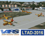
Etimesgut AB/Ankara(Turkey) Airport (LTAD/ANK) scenery (2016) for Flight Simulator 2004 (Fs9). This military airport is in Ankara, the capital of Turkey. Esenboga (LTAC) is very close to the airport. Flight training is given here. The pilot is raised. There are two large and long aprons on either side of the runway. This aprons has a very large number of flight training buildings and hospitals. Bombardier, Gulfstream, Cessna 560XL Excel, Businesss Jet, CL215-Fire fighter, Dash8, Saab-340, CN235, etc. GA airplanes have been configured for parking. Thanks for using. Scenery design by VAPS (vaps.hooxs.com)
| Filename: | Etimesgut_ABAnkaraTurkey_Airport_LTADANK_scenery_2.zip |
| License: | Freeware |
| Added: | 14th April 2017, 07:18:47 |
| Downloads: | 974 |
| Author: | Pilot Hoca (VAPS) |
| Size: | 8.88 MB |
© 2001-2026 AVSIM Online
All Rights Reserved
Privacy Policy |