
Where Flight Simulation Enthusiasts Gather from Around the World!
AVSIM Library - Search Results

| Category: Flight Simulator 2004 - AI Aircraft | |
| McDonnell Douglas F-15A and F-15B |

|
Images related to this file:
File Description:
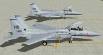
One example of each aircraft in 7th TFS (Holloman) scheme, circa 1986. Also seen in Europe at that time. Paint kit included, but no flight plans. 7 LODs with realistic flight dynamics. Separate pack in FSX native code is in JYAI_F15_A_B_FSX_1.zip. Note that these aircraft are not intended to be user-flyable.
| Filename: | McDonnell_Douglas_F15A_and_F15B.zip |
| License: | Freeware, limited distribution |
| Added: | 29th August 2015, 09:29:22 |
| Downloads: | 418 |
| Author: | John Young and Mike McIntyre, MAIW |
| Size: | 19.18 MB |
| Category: Flight Simulator 2002 - Flight Plans | |
| Final Approach Flights |
|
File Description:
This is two Flights that put you at the final approach at the two of the biggest airports in the world (KSFO and VHHH). It is a really good trainig flight for the most scary part of your flight.
Good Luck and Happy Landings! NOTE: requires Meljet's 747-400 in UAL Livery
| Filename: | Final_Approach_Flights.zip |
| License: | Freeware, limited distribution |
| Added: | 10th November 2002, 00:18:41 |
| Downloads: | 940 |
| Author: | Aircraft Inc. Flights and Add-ons |
| Size: | 7.77 KB |
| Category: Flight Simulator X - Utilities | |
| FSLauncPad 2.12 |
|
File Description:
FsLaunchpad 2.12 still in life because more than 2000 users appreciate to launch fastly their FS2004/FSX/Prepar3D Flight Simulator. This version correct some bugs and inversion selection in launchpad. FSL have possibility to create a Google Earth file from flight plan and see airports and your adds-on near from each waypoint. Compatible with FSX, P3D, FS2004 and Plan-G Flight Plans; Select your Addon sceneries from flight plan result search. All 24490 airports from FSX. Each Airport Google Earth popup now includes links for weather from Aviation Digital Data Service (ADDS) and airport information from wikipedia and more. Improve addons source and destination separators; Detect if you run FSL as Administrator. Tested with Windows 7, 8 and 10. By Pierre Legault.
| Filename: | FSLauncPad_212.zip |
| License: | Freeware, limited distribution |
| Added: | 9th April 2016, 15:23:13 |
| Downloads: | 298 |
| Author: | Pierre Legault |
| Size: | 3.28 MB |
| Category: Flight Simulator 2004 - AI Flight Plans | |
| Cityjet and VLM - Winter 2015 / 16 |
|
Images related to this file:
File Description:

These are the complete Winter 2015-16 flight plans for Cityjet and VLM including charters and actual positioning flights.
I have based both flight plans on the week 8-14 November 2015.
VLM has demerged from Cityjet and has begun operating an increasing number of scheduled and charter flights under its own callsign. VLM no longer operates for Aurigny, and its production for Cityjet is down to two aircraft. I have separated out the Cityjet production. This is not entirely what happens in real life, but at least you'll get the callsigns right.
Cityjet and VLM use alphanumeric callsigns which we are not able to reproduce in Flight Simulator, so I have used the commercial flight numbers throughout.
| Filename: | Cityjet_and_VLM__Winter_2015__16.zip |
| License: | Freeware |
| Added: | 17th November 2015, 21:05:40 |
| Downloads: | 320 |
| Author: | Alexander Michael |
| Size: | 6.29 KB |
| Category: Flight Simulator 2004 - AI Flight Plans | |
| Transmile Air Service - Winter 2006 |
|
File Description:
Winter 2006 flight plans for Transmile Air Services for use with Flight Simulator 2002 or 2004 AI traffic. They are based on the timetable at the company's web site and other sources. Transmile operate daily cargo services to various locations in Asia and long-distance services to Los Angeles via Hong Kong, which also make a technical stop at Anchorage, Alaska. The fleet consists of Boeing 727-200 and Douglas MD11 aircraft.
This file corrects a number of errors in previously released flight plans, see the readme.txt file within for details. You will need the Traffic Tools software by Lee Swordy to compile these plans for use with Flight Simulator.
[File re-uploaded at request of AVSIM]
| Filename: | Transmile_Air_Service__Winter_2006.zip |
| License: | Freeware |
| Added: | 29th May 2010, 09:33:22 |
| Downloads: | 917 |
| Author: | John Hinson |
| Size: | 2.83 KB |
| Category: Flight Simulator 2004 - Utilities | |
| Simradar Pilot Network v2.0 |
|
File Description:
The Simradar Pilot Network it's an in-flight online service for virtual pilots where features such
as online weather METAR's, online scratchpad, flight simulation news and an easy to use tool to add
or remove URL's for easy browsing is accesible right from the electronic kneeboard inside flight
simulator 2004 without pausing or leaving your flight simulator session. The Simradar Pilot Network
is great for the pilot who wants to have a PDA like tool in the cockpit while flying in order to
browse web pages, take notes, read news, check the weather or simply have fun. If you have not
tried this utility before do so now and see what you've been missing. By the way, this utility is completely FREE!
| Filename: | Simradar_Pilot_Network_v20.zip |
| License: | Freeware |
| Added: | 6th July 2004, 01:28:39 |
| Downloads: | 1,654 |
| Author: | Robert Hansen |
| Size: | 265.11 KB |
| Category: Flight Simulator X - Gauges | |
| FLTInfo V2 |
|
Images related to this file:
File Description:

This gauge has been developed for FSX Flight Simulator SP2 or SP1. It should also work with Acceleration, but this is not guaranteed by the author.
The gauge provides flight information for the pilot regarding the destination airport in terms of frequencies, runway conditions, altitude, bearing and distance, and basic information about the flight plan like current travelled miles and a estimated calculation about the Top Of Descent (TOD ) decision point.
This Version 2 includes 3 additional information pages for the runway layouts of the destination and the departure airport, and a page which provides graphical information about the terrain level relative to the aircraft on the selected flight plan.
For more information and installation instructions see the documentation inside the zip file.
| Filename: | FLTInfo_V2.zip |
| License: | Freeware, limited distribution |
| Added: | 12th October 2012, 18:05:11 |
| Downloads: | 1,553 |
| Author: | Dietmar Loleit |
| Size: | 853.38 KB |
| Category: Flight Simulator 2004 - Flight Plans | |
| World Challenge Guyana |
|
File Description:
This challenge picks up where the Eastern Venenzuela left off at. This time which aircraft you pick matters, Because you will keep the same aircraft until you reach Brazil. Its a three country swing challenge. Here in Guyana watching your flight level matters big time, some places have will have you taking off from a flight level of 554ft and trying to climb to a flight level of 2400ft just to clear the mountain rigde ahead without smacking it the side of the mountain. or trying to slow yourself down in time to keep from sailing off the end of the landing strip right off the edge of a cliff. A Navigation Log comes with your flight plan that I have included.
| Filename: | World_Challenge_Guyana.zip |
| License: | Freeware |
| Added: | 28th June 2007, 21:39:46 |
| Downloads: | 182 |
| Author: | Hosea Robertson |
| Size: | 4.18 KB |
| Category: Flight Simulator 2004 - Utilities | |
| Random Failure v1.0 |
|
File Description:
This is a random failure generator for MS Flight Simulator 2002
and 2004. It relies on Flight Simulator's built-in failure system,
but does not requires the failures to be "planned" each time you
start a flight. When Random Failure is running, just expect one
or several failures to happen at any time, with a configurable
probability.
Random Failure is currently able to generate the following failures :
altimeter, attitude indicator, mag compass, fuel indicators, direction
indicator, vertical speed indicator, ADF, NAVs, COMs, transponder,
first engine, pitot, vacuum and electrics. Needs FSUIPC (registered for FS2004).
| Filename: | Random_Failure_v10.zip |
| License: | Freeware, limited distribution |
| Added: | 14th November 2003, 00:12:50 |
| Downloads: | 2,819 |
| Author: | Frédérik Bilhaut |
| Size: | 18.88 KB |
| Category: Flight Simulator 2002 - Flight Plans | |
| 36RTWest |
|
File Description:
An FS2002 GPS flight Plan. The 36th in a series of Round the World flight plans for the FS2002 default scenery. Depart Tribhuvan International (VNKT) runway 02, Nepal and arrive 55 minutes later at Nepalgunj (VNNG) runway 26, Nepal. A climb into the Himalayas is followed by a lively trip through the snow capped peaks. A VFR finals follows (with instructions ). The flight briefing (Word and text) is for a B737-400, it contains climb, cruise, top of descent and fuel loading details, waypoint timings and destination details.
| Filename: | 36RTWest.zip |
| License: | Freeware |
| Added: | 21st July 2002, 17:27:44 |
| Downloads: | 871 |
| Author: | The Ancient Brit |
| Size: | 21.11 KB |
© 2001-2026 AVSIM Online
All Rights Reserved
Privacy Policy |