
Where Flight Simulation Enthusiasts Gather from Around the World!
AVSIM Library - Search Results

| Category: Orbiter - Spaceships | |
| Surveyor Lunar Lander 1.0 |

|
File Description:
The Surveyor program consisted of seven unmanned lunar missions that were launched between May 1966 and January 1968. Five of these spacecraft, Surveyor 1, 3, 5, 6, and 7 successfully soft-landed on the lunar surface. In addition to demonstrating the feasibility of lunar surface landings, the Surveyor missions obtained lunar and cislunar photographs and both scientific and technological information needed for the Apollo manned landing program. Four spacecraft, Surveyor 1, 3, 5, and 6, returned data from selected mare sites from Apollo program support, and Surveyor 7 provided data from a contrasting rugged highland region.
The Orbiter version brings to you the historical flight of this unmanned lunar landing probe. The flight plan should bring you within 10,000 km of the Lunar surface. With one mid course correction, and enough practice, you can land it the moon.
| Filename: | Surveyor_Lunar_Lander_10.zip |
| License: | Freeware |
| Added: | 8th December 2004, 14:57:05 |
| Downloads: | 872 |
| Author: | James Williams |
| Size: | 1.97 MB |
| Category: Flight Simulator 2004 - Panels | |
| Beaver Panel 2005 Config |
|
File Description:
This is a panel.cfg file for use with Jean-Pierre Langer and Arne Bartels Beaver panels based on photos by Larry Smith. It is made to be compatible with John L. Woodward's Beaver 2005 aircrafts that were recently released. This version enables the Photoreal 2D side views while still keeping the Virtual Cockpit. The 2D panel and side views are extremely photorealistic and excellent looking. I think you will really enjoy them if you are wanting a totally freeware DHC-2 Beaver. This is just a panel.cfg file and requires you to download the panel by Jean-Pierre Langer and Arne Bartels, and of course one or both of John's L. Woodward's Beavers. The panel is in the FS2002 Panels section of the Avsim library and the filename is bvr_pnls.zip. John's FS2004 aircrafts are filenames beaver_wheels_2005.zip and beaver_floats_2005.zip. Enjoy!
| Filename: | Beaver_Panel_2005_Config.zip |
| License: | Freeware |
| Added: | 7th October 2005, 23:26:16 |
| Downloads: | 2,814 |
| Author: | Jimmy Richards |
| Size: | 13.08 KB |
| Category: Flight Simulator 2004 - Scenery | |
| The Greater Toronto Area for Ultimate Terrain 1.2 Part 1 |
|
File Description:
Part 1 of Flight Ontario's scenery for the Greater Toronto Area for Ultimate Terrain. The scenery is bounded by Detroit in the west, Kingston in the east, Huntsville in the north and Buffalo in the south and features: * all-season scenery * custom water textures * completely modelled Toronto Airports...CYTZ (Toronto Island) and CYZD (Downsview-home to Bombardier Aerospace and the Canadair Regional Jet and Dash-8, and the Toronto Aerospace Museum) * Niagara Helicopters CPQ3 (NEW) *custom autogen for the GTA * Custom landclass for southern Ontario * prominent features around Hamilton include the Burlington Skyway,lift bridge and steel mills * the Welland Canal is featured with lift bridges from Pt Weller to Pt Colborne * the Niagara area includes two hydro generating plants with reservoirs * compatibility with SimFlyers CYYZ.
This scenery is downloadable in two parts and both parts are essential.
| Filename: | The_Greater_Toronto_Area_for_Ultimate_Terrain_12_P.zip |
| License: | Freeware |
| Added: | 31st December 2005, 18:39:52 |
| Downloads: | 13,895 |
| Author: | Jim Kanold - Flight Ontario |
| Size: | 62.05 MB |
| Category: Flight Simulator X - Scenery | |
| Mountain & Desert Texture Mod (Fixed) |
|
File Description:
Created to modify the existing textures in FSX to offer a better representation of AB, BC, AK mountain regions, and reduces the amount "desert" texture look overall. The small batch file simply copies and renames better existing textures from within FSX - to be applied for these regions. Overall it reduces the amount of light desert textures, gives you more rock where there was sand, provides a greener sub base and transitions, darker mountian slides, and reduces the plain white snow coverage in the mountains allowing more rock to be shown. Blocky shadows in snow are now minimal, due to the snow textures changes and contrast in terrain. Updated - This version superceeds the original version 1.0a, and is for both new and previous installations. Existing users please download this updated version and follow the instructions within the readme.
| Filename: | Mountain__Desert_Texture_Mod_Fixed.zip |
| License: | Freeware, limited distribution |
| Added: | 17th November 2006, 11:17:17 |
| Downloads: | 8,371 |
| Author: | Garett Schmidt |
| Size: | 279.31 KB |
| Category: Flight Simulator X - Missions | |
| Discover FSX flight 6 : Iraqi-Iranian border - Military Recon / Patrol Flight Plan |
|
File Description:
As Part of the Coalition Force deployed in Iraq, your squadron based at Kirkuk AirForce base in Northern Iraq
has been tasked with routine border patrol and recon flights along the Northern Iraqi-Iranian border, the terrain consists
of beautiful valleys and ice cap mountins as well as awsome vistas and ranges, you will need to maintain low level carpet
flying and try and stay close to the main roads when possible. If your flying a military helicopter,
get close to whatever looks suspicious as long as your gunners are alert, Military Command indicates movement of extremist
terrorists and weapons in these desolate areas-----dont stray off course or you will cause an international incident-----
Just place the included (Plan File) in your saved routes and flights folder(accessed from Desktop) and load it from the
FSX flight planner)
| Filename: | Discover_FSX_flight_6__IraqiIranian_border__Milita.zip |
| License: | Freeware |
| Added: | 6th January 2008, 15:37:13 |
| Downloads: | 3,133 |
| Author: | Ali Zied |
| Size: | 468.22 KB |
| Category: Flight Simulator X - Panels | |
| Alphasim F-111 Panel Package Version 2.0 |
|
Images related to this file:
File Description:
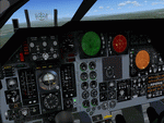
This upgrade to the Alphasim F-111 adds a Weapons System Operator Panel with default and old avionics packages, Working TERRAIN FOLLOWING RADAR scope
shows accurate ground mapping ahead of aircraft in 5, 10 or 15 mile ranges, THREAT WARNING DISPLAY shows airborne AI aircraft in 20 or 40 mile ranges, Ground Attack RADAR displays airports and AI aircraft on default panel and airports as ground targets in ranges of 5,10,30,80 and 200 miles on old avionics panel, Shockwave Lights ready, Updated afterburner effects, INS (old avionics panel) displays working digital readout of latitude, longitude, and altitude, TFR and TWR gauges automatically change brightness between day and night to match lighting conditions.New Autopilot and Lighting control panels. Features custom gauges created by Dietmar Loleit for this project. You must have the Alphasim F-111 aircraft package for this panel
| Filename: | Alphasim_F111_Panel_Package_Version_20.zip |
| License: | Freeware |
| Added: | 7th November 2009, 12:11:41 |
| Downloads: | 917 |
| Author: | Steve Hess |
| Size: | 15.88 MB |
| Category: Prepar3D V1-4 - Aircraft Repaints, Textures and Modifications | |
| Transbrasil 1998 AI Package |
|
File Description:
In 1998, Transbrasil was the 3rd largest airline in Brazil, but nearing the end of it's life, ceasing operations in 2001. Transbrasil had a decent number of 767s in 1998 flying both around Brazil and to Europe and North America, while 737-300s and 737-400s served the domestic market. Planes had the wings and titles painted in different vivid colors making for good variety, and there was a Futura hybrid 737-400 as well as a new 1998 livery applied to some 737s. Flightplans by Chasen Richardson and Raphael Rodrigues. Repaints by Jonathan Alba included for the FAIB 737-300, 737-400, 767-200, and 767-300. Part of the 1998 Flight Simulator Project. Follow us on Facebook at facebook.com/flightsim98 and on instagram as @bayviationsim. For more Retro AI, check out the forums at: http://retroai.proboards.com/
| Filename: | Transbrasil_1998_AI_Package.zip |
| License: | Freeware, limited distribution |
| Added: | 5th November 2019, 06:12:47 |
| Downloads: | 291 |
| Author: | Jonathan Alba, Raphael Rodrigues,Chasen Richardson\Bayviation |
| Size: | 15.69 MB |
| Category: Flight Simulator 2004 - Aircraft Repaints, Textures and Modifications | |
| Swiss Air Force Hunter Package |
|
File Description:
This is my final package of 21 Swiss Air Force Hunters for Dave Garwoods wonderful model(hunterpak6.zip needed!). The versions show examples of almost every Swiss Hunter Squadron, including rare special schemes like the "Papyrus", winter camo, tiger scheme etc. All external textures were completely redrawn and now show correct Swiss camouflage and stencelling and come in both high resolution and low resolution versions (intended for multiplayer and AI traffic). Also included is an extensive installation manual with infos on every featured aircraft and a screenshot/wallpaper gallery. The Package completely replaces all my previously published packages. Please unpack the folder completely to allow the Manual to work properly and follow the instructions in the provided "Superpack manual.htm" file closely.
Many thanks to Dave Garwood and his team for providing the flightsim community with the superb Hunter!
| Filename: | Swiss_Air_Force_Hunter_Package.zip |
| License: | Freeware |
| Added: | 25th October 2004, 22:39:28 |
| Downloads: | 1,872 |
| Author: | Markus Schindler |
| Size: | 45.43 MB |
| Category: Flight Simulator 2004 - Scenery | |
| Fort Good Hope CZGH - Northwest Territories, Canada |
|
Images related to this file:
File Description:
This is the second in a series of airfields that follow that early access route to the Canadian northern shore, the Mackenzie River. At the far northern end of the river there are Tuktoyaktuk, Inuvik, and Fort McPherson, all posted. Fort Good Hope is at 268 feet ASL and on the east bank of the Mackenzie, 180 miles southeast of Fort McPherson and 100 miles west of Great Bear Lake. The town has a population of around 560, and the main sources of income are from the traditional trapping and hunting. The airport is a mile south of the town, and has almost 4,000 feet of gravel runway. There are scheduled flights to the town by North Wright; I also have two AI GA flights and a Buffalo Airways delivery trip that hops north and south from field to field.
| Filename: | Fort_Good_Hope_CZGH__Northwest_Territories_Canada.zip |
| License: | Freeware, limited distribution |
| Added: | 4th July 2014, 21:03:03 |
| Downloads: | 278 |
| Author: | Roger Wensley |
| Size: | 3.08 MB |
| Category: Flight Simulator 2004 - Scenery | |
| PAMR - Merrill Field - Anchorage, Alaska |
|
Images related to this file:
File Description:
Merrill Field is in Anchorage Alaska, between Anchorage International to the southwest and and Elmendorf Air Force Base to the north. It caters for general aviation and is the land equivalent of the Lake Hood float plane base (see my post) with fuel and numerous maintenance facilities, and several hundred parking spots for small planes. There are three runways, and the longest is 4,000 feet of 100 feet wide asphalt, the second 2,635 feet of asphalt 75 feet wide, and the third 2,000 feet of 60 feet wide gravel. It is a controlled airfield with a modern control tower. There are almost 50 buildings on the field and three quarters of them have been modeled specifically for this scenery. The download includes a LITE version for older computers as there are a lot of static parked aircraft.
| Filename: | PAMR__Merrill_Field__Anchorage_Alaska.zip |
| License: | Freeware, limited distribution |
| Added: | 3rd January 2011, 23:11:31 |
| Downloads: | 1,124 |
| Author: | Roger Wensley |
| Size: | 6.94 MB |


© 2001-2026 AVSIM Online
All Rights Reserved
Privacy Policy |