
Where Flight Simulation Enthusiasts Gather from Around the World!
AVSIM Library - Search Results

| Category: Flight Simulator X - Utilities | |
| FS Earth 5.0 for Google Earth |

|
File Description:
This program acts as an interface between Flight Simulator X and Google Earth, letting to follow a flight in real time, over the satellite images generated by Google Earth. Flights can be saved, and many options are available for fine tuning the performance, as well as the map's style (zoom, tilt, orientation). Works on a single computer running FSX and Google Earth all together or, for best experience, can be used on two networked computers running respectively FSX (master) and Google Earth (slave). AI and Multiplayer traffic is also displayed in Google Earth, with course prediction and other information. Requires Flight Simulator X and Google Earth. The program running in trial mode works only around Anchorage, Alaska, (PANC / ANC) for a maximum of five minutes per flight session. Version 5.0 has improved compatibility with latest releases of Google Earth and several additional improvements. A version for FS2004 is available also.
| Filename: | FS_Earth_50_for_Google_Earth.zip |
| License: | Shareware, time limited |
| Added: | 19th July 2007, 00:46:27 |
| Downloads: | 1,104 |
| Author: | Luciano Napolitano |
| Size: | 2.44 MB |
| Category: Flight Simulator X - Scenery | |
| GPS Enabled Acceleration Carrier Aegean |
|
File Description:
This carrier is for FSX Acceleration owners and allows the user to start from the deck in FSX, by using the supplied airport code LG57. The carrier is the Acceleration model and includes full use of the cat launch and arrestor cable. Their are two models supplied, a static and a moving version. The static version allows the use of GPS approach from any airport in the world, and start from the deck all day. The moving version allows the same features before 7am GMT and after arrival at the destination port. The user could use the FSX menu to get on board the deck area of this carrier prior to 7am GMT and then sail with it. The destination allows full use of GPS facilities at a nearby airport whilst the carrier is in that port too. Full and easy installation/uninstallation instructions are supplied.
| Filename: | GPS_Enabled_Acceleration_Carrier_Aegean.zip |
| License: | Freeware, limited distribution |
| Added: | 23rd February 2008, 15:55:23 |
| Downloads: | 1,112 |
| Author: | Steve Brooks |
| Size: | 99.51 KB |
| Category: Flight Simulator X - Scenery | |
| GPS Enabled Acceleration Carrier Saudi |
|
File Description:
This carrier is for FSX Acceleration owners and allows the user to start from the deck in FSX, by using the supplied airport code OB52. The carrier is the Acceleration model and includes full use of the cat launch and arrestor cable. Their are two models supplied, a static and a moving version. The static version allows the use of GPS approach from any airport in the world, and start from the deck all day. The moving version allows the same features before 7am GMT and after arrival at the destination port. The user could use the FSX menu to get on board the deck area of this carrier prior to 7am GMT and then sail with it. The destination allows full use of GPS facilities whilst the carrier is in that port too. Being based in and around Iran/Iraq their are many possibilities.
| Filename: | GPS_Enabled_Acceleration_Carrier_Saudi.zip |
| License: | Freeware, limited distribution |
| Added: | 23rd February 2008, 15:55:41 |
| Downloads: | 1,198 |
| Author: | Steve Brooks |
| Size: | 103.58 KB |
| Category: Flight Simulator 2004 - Scenery | |
| Tillsonburg CNQ4 in Ontario Canada REPLACEMENT |
|
File Description:
This is a replacement (though complete in itself) for my original Tillsonburg post with the corrected office building included. Tillsonburg is a small town in southwest Ontario, mid way between Toronto, Buffalo, and Detroit. The airfield is some four miles north of the town. It was originally built by the RCAF as an emergency grass field to support flying training in WW2. It now has two grass runways, each 2,400 feet long, and another 4,000 feet long that is asphalt. There is a company that carries out painting and ulholstery work, a flight school, and of course the Canadian Harvard Aircraft Association, which is a volunteer organisation that does what the title suggests and takes care of Harvards, I think six of them plus a Tiger Moth, and something else. And when I was there two years ago and in the winter there was a licensed AME just starting up.
| Filename: | Tillsonburg_CNQ4_in_Ontario_Canada_REPLACEMENT.zip |
| License: | Freeware |
| Added: | 12th November 2008, 14:48:26 |
| Downloads: | 664 |
| Author: | Roger Wensley & Jim Turner |
| Size: | 1.43 MB |
| Category: Flight Simulator X - Panels | |
| FSX Alpha F-111 Aardvark HUD Navigation/Situation awareness panels |
|
Images related to this file:
File Description:
FSX Alphasim F-111 Aardvark HUD Navigation/Situation awareness cockpit
with massive amount of digital data. Must have ALPHASIM F-111 Aardvark to
build up this complete and separate F-111. Exceptional capability cockpit
Comprising: Pilot, WSO and virtual panels.3 MFD with 19 selectable pages
of data. 3 GPS type moving maps. 16 Nearest airports page with full City
names and ICAO entry capable displays in HUD. autopilot. autothrottle
and TFR. Enhanced HUD is selectable in all views including 10 camera
views. All data clearly readable size. Aircraft carrier capable.
Effects: bombs. missiles. flares. dump and burn. exhaust trail.
Detailed 40 pge Flight Manual plus docs folder.Configuration ensures
crisp and extremely precise controlled flight even down to 10 ft AGL.
This panel will set a new benchmark of the amount and type of data
provided and its presentation. Possibly the best pilots aircraft ever.
By Karol Chlebowski.
| Filename: | FSX_Alpha_F111_Aardvark_HUD__NavigationSituation_a.zip |
| License: | Check within download |
| Added: | 29th November 2009, 15:56:47 |
| Downloads: | 412 |
| Author: | Karol Chlebowski |
| Size: | 24.72 MB |
| Category: Prepar3D V1-4 - Scenery | |
| Benina International Airport HLLB |
|
Images related to this file:
File Description:
This Addon for P3D V4, Currently the most realistic and best addon for HLLB airport.
I tested the addon on V4.3 and V4.4 and it works fine.
it has many changes comparing with default airport, here is some:
- ILS 33L fixed.
- APT position aligned.
- Correct Taxiway designators.
- Corrected stands and thier positions, And many...
some information about this airport.:
Benina International Airport (IATA: BEN, ICAO: HLLB) (Arabic: مطار بنينة الدولي‎) serves Benghazi, Libya. It is located in the town of Benina, 19 kilometres (12 mi) east of Benghazi, from which it takes its name. The airport is operated by the Civil Aviation and Meteorology Bureau of Libya and is the second largest in the country after Tripoli International Airport. Benina International is also the secondary hub of both Buraq Air and flag carrier, Libyan Airlines.
| Filename: | Benina_International_Airport____HLLB.zip |
| License: | Freeware |
| Added: | 3rd February 2019, 18:34:54 |
| Downloads: | 991 |
| Author: | Hamza Aswaid |
| Size: | 41.43 MB |
| Category: Flight Simulator X - Scenery | |
| RAF Folkingham |
|
File Description:
Royal Air Force Station Folkingham or RAF Folkingham is a former Royal Air Force station located south west of Folkingham, Lincolnshire and about 29 miles (47 km) due south of county town Lincoln and 112 miles (180 km) north of London, England.
Opened in 1940, it was used by both the Royal Air Force and United States Army Air Forces. During the war it was used primarily as a troop carrier airfield for airborne units and as a subsidiary training depot of the newly formed Royal Air Force Regiment. After the war it was placed on care and maintenance during 1947 when the RAF Regiment relocated to RAF Catterick.
You will need some additional scenery files by Ted Andrews and Ian Pearson which can be found at http://www.ianpsdarkcorner.co.uk, otherwise on the runway and peri track show. Ted Andrew - small buildings and Ians FSX Object Libraries.
| Filename: | RAF_Folkingham.zip |
| License: | Freeware |
| Added: | 8th October 2015, 17:55:15 |
| Downloads: | 298 |
| Author: | Terry Boissel |
| Size: | 9.59 KB |
| Category: Flight Simulator X - Scenery | |
| Ghat HLGT Libya |
|
Images related to this file:
File Description:
Ghat is a medium-sized airport located in the south-west of Libya, near Algerian border, and 10 miles north of the city of Ghat. In early 2010s Ghat was undergoing major renovatios, but civil war in Libya has put these plans on hold. While all runways and taxiways were recently repaved, new passenger terminal is still unfinished, and air traffic is almost non-existent. Except from military and cargo planes, the only regular passenger flight to Ghat nowadays is Air Libyan from Tripoli: their A320 is visiting this place twice a week. This scenery has super-accurate layout, precise marking, and correct navaids according to the latest satellite images and charts. Photo background blends perfectly with ORBX Global. Unfinished new terminal with the construction site. Taxi signs were added for convenience. Enhanced city of Ghat and surrounding landclass. Made for P3Dv3, tested on P3Dv4 and FSX:SE. Made by Dmitriy Kozyrev.
| Filename: | Ghat_HLGT_Libya.zip |
| License: | Freeware |
| Added: | 27th September 2017, 06:18:00 |
| Downloads: | 1,225 |
| Author: | Dmitriy Kozyrev |
| Size: | 31.43 MB |
| Category: Flight Simulator X - Scenery | |
| Amsterdam Schiphol - EHAM - The Netherlands |
|
Images related to this file:
File Description:
This is a very accurate version of Schiphol Airport with two optional files and made only for FSX: one version with the Crosswind runways activated and in full operation where all six runways will be used for takeoff/landing and one version as the default airport runway operation, assigned parking as per their website with extra parking including gates for the A380, where there are dual jetways the static jetways are set to "Very Dense", taxiways and taxi signs updated to the latest charts, retention ponds and drainage canals added, aviation museum removed which has now moved to Lelystad Airport, fire brigade practice ground and airport support building included, extra fuel trucks, support vehicle roads rebuilt and many other scenery improvements and objects added, airport views are from the roof of the control tower (when in tower view) please view the readme before installation
| Filename: | Amsterdam_Schiphol__EHAM__The_Netherlands.zip |
| License: | Freeware, limited distribution |
| Added: | 7th December 2017, 07:21:15 |
| Downloads: | 56,064 |
| Author: | Ray Smith |
| Size: | 7.31 MB |
| Category: Flight Simulator 2004 - Scenery | |
| LFJA Chaumont_Semoutiers AB |
|
Images related to this file:
File Description:
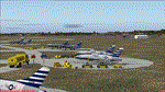
From 1950 to 1967 the USAF set up and maintained bases in France, with the agreement of the French government, as part of its commitment to the North Atlantic Treaty Organisation. Chaumont AB was one of the ten main air bases which supported both attack and air defence capabilities. Many people do not appreciate the sheer extent of the USAF bases in France at this time and the reasons leading to the USAF departure in 1967. There is a link to a fine article on all this included.
This scenery and traffic represent Chaoumont Air Base during the years 1955 to 1962. Custom Tower and Hangars by Dan French along with a large number of custom paints by DeltataDart for the many types of aircraft represented over this period. Traffic files and the aircraft and paints needed are provided for 1955 (including the Skyblazer Demonstration Team), 1957, 1959 and 1962.
| Filename: | LFJA_Chaumont_Semoutiers_AB.zip |
| License: | Freeware |
| Added: | 22nd November 2023, 16:08:16 |
| Downloads: | 111 |
| Author: | Al von Pingel, Ken Lawson, Dan French, DeltaDart |
| Size: | 38.9 MB |


© 2001-2026 AVSIM Online
All Rights Reserved
Privacy Policy |