
Where Flight Simulation Enthusiasts Gather from Around the World!
AVSIM Library - Search Results

| Category: Flight Simulator 2004 - Scenery | |
| San Luis Valley Regl - KALS |

|
Images related to this file:
File Description:
FS2004 Scenery - San Luis Valley Regional/Bergman Field Airport serves Alamosa and Alamosa County and is owned by the City And County of Alamosa, Colorado, USA. The airport has more than one runway. The longest is a paved runway extending 8800 feet. The facility is at an elevation of 7535 feet at a distance of about 2 miles from Alamosa. The Airport (IATA: ALS, ICAO: KALS), also known as Bergman Field, is a public airport used for general aviation, but is also served by one commercial airline. Created with EZ Scenery. EZ Scenery libraries required. Scenery created over USA Roads. By John B. Loney, Jr.
| Filename: | San_Luis_Valley_Regl__KALS.zip |
| License: | Freeware, limited distribution |
| Added: | 23rd May 2010, 01:31:13 |
| Downloads: | 1,032 |
| Author: | John B. Loney, Jr. |
| Size: | 669.56 KB |
| Category: Flight Simulator 2004 - AI Flight Plans | |
| Export Hawks Part 11: BAe Hawks Complete AI Package |
|
File Description:
Military AI Works is proud to present the last part in a multi-part series covering current users of the various models of the venerable BAe Hawk, BAe Hawks. This package depicts the various Hawk models operated by the civilian defense contractor BAe Systems, out of their facility located at BAe Warton. Credits: Models by Nick Black, Henry Tomkiewicz, Project AI, Dave Friswell and UkMil, Repaints by Nick Black and Graham King, AI Flight Dynamics/FDE Design (Hawks) by Mike MacIntyre, Flightplans by Gary Barker, AFCADs by Duncan MacKellar, Gary Barker and Mike Guenthner, Callsigns by Nick Black and Stewart Pearson and Custom Scenery by John Burtenshaw.
| Filename: | Export_Hawks_Part_11_BAe_Hawks_Complete_AI_Package.zip |
| License: | Freeware, limited distribution |
| Added: | 25th December 2008, 10:12:05 |
| Downloads: | 2,905 |
| Author: | Nick Black, Military AI Works (MAIW) |
| Size: | 4.91 MB |
| Category: Flight Simulator 2004 - Scenery | |
| McDuffs' Aircraft Service |
|
File Description:
McDuffs' Aircraft Service is a fictional short hop bush scenery for Tongass Fjords Scenery by: FSADDON This airstrip is a privately owned, offering a maintenance bay, pilot's lounge, and camping facility. If your on the go and need a break or fix stop on in grab some coffee and something to eat from the pilot's lounge. *** NOTE TO SELF-LAND BEFORE DUSK IN MOST CONDITIONS *** - TO USE THIS SCENERY YOU MUST HAVE THE FOLLOWING ADDONS FOR FS2004 INSTALLED: - FREIGHT DOGS SCENERY BY: (AEROSOFT OR FSADDON) - TONGASS FJORDS SCENERY BY: (FSADDON) - ULTIMATE TERRAIN ALASKA / CANADA BY: (FLIGHT ONE) - EZ SCENERY CREATOR OBJECTS LIBRARY BY: (ABACUS) - LAGO FSE (OPTIONAL)
| Filename: | McDuffs_Aircraft_Service.zip |
| License: | Freeware |
| Added: | 31st August 2006, 00:35:59 |
| Downloads: | 1,072 |
| Author: | Michael Woolsey |
| Size: | 5.01 MB |
| Category: Flight Simulator 2004 - Aircraft Repaints, Textures and Modifications | |
| VMFA-321 McDonnell-Douglas F-4S Phantom II MG 01 1985 |
|
Images related to this file:
File Description:
F-4S 153809 (MG 01) of VMFA-321 "Hells Angels" stationed at NAF Andrews AFB in 1985. This was the first F-4S accepted by VMFA-321 in November 1984 from the Naval Air Rework Facility (NARF) at MCAS Cherry Point, NC and remained with the squadron until 1991 when it was subsequently assigned to VX-30 at Point Mugu, CA with the modex 108. Probably not exact, just the work of a Phormer Phantom Phixer from VMFA-321 and VMFP-3 having some Phun. Special Thanks to Gus Robatto for allowing me to use his Tex2 texture. ©ALPHA Simulations 2004\n\n
| Filename: | VMFA321_McDonnellDouglas_F4S_Phantom_II_MG_01_1985.zip |
| License: | Freeware |
| Added: | 13th February 2011, 05:47:10 |
| Downloads: | 419 |
| Author: | Tony Mikos |
| Size: | 2.1 MB |
| Category: Flight Simulator X - Scenery | |
| TNCA - Queen Beatrix Intl. Airport (Aruba) |
|
File Description:
Queen Beatrix International Airport (IATA: AUA, ICAO: TNCA), in Oranjestad, Aruba, is a fairly large aviation facility that has
flight services to the United States, most countries in the Caribbean, the northern coastal countries of South America and some parts
of Europe, notably the Netherlands. It was named after Queen Beatrix of the Netherlands, the head of state of Aruba.
This airport used to serve as the hub for bankrupt airline Air Aruba, which was for many years an international airline.
Before Aruba's separation from the Netherlands Antilles in 1986 it was also one of three hubs for Air ALM. The airport has
a new airline, Tiara Air and Aruba Airlines.
| Filename: | TNCA__Queen_Beatrix_Intl_Airport__Aruba.zip |
| License: | Freeware |
| Added: | 22nd April 2009, 07:15:26 |
| Downloads: | 2,305 |
| Author: | Daniel Louvet |
| Size: | 1.8 MB |
| Category: Flight Simulator 2004 - Scenery | |
| Homer Airport PAHO |
|
Images related to this file:
File Description:
FS2004 Scenery - Homer Airport (IATA: HOM, ICAO: PAHO, FAA LID: HOM) is a state-owned public-use airport located two nautical miles (4 km) east of the central business district of Homer, a town in the Kenai Peninsula Borough of the U.S. state of Alaska.
Homer Airport covers an area of 1,040 acres (421 ha) at an elevation of 84 feet (26 m) above mean sea level. It has one runway designated 3/21 with a 6,701 x 150 ft (2,042 x 46 m) asphalt pavement, and a facility for floatplanes on nearby Beluga Lake (5BL). This package consists of PAHO only. By John B. Loney, Jr.
| Filename: | Homer_Airport_PAHO.zip |
| License: | Freeware, limited distribution |
| Added: | 21st December 2010, 04:21:22 |
| Downloads: | 1,674 |
| Author: | John B. Loney, Jr. |
| Size: | 7.73 MB |
| Category: Prepar3D V1-4 - Scenery | |
| YSWS West Sydney Airport P3Dv4 basic |
|
File Description:
Western Sydney International (Nancy-Bird Walton) Airport (YSWS) will be a 24/7 facility. It is under construction and due for opening to regular services in late 2026. Aircraft have landed here for the purpose of development and testing. This scenery was done with ADE4 using P3Dv4 default objects. It is very basic, but placed as best possible based on Google Earth and Air Services Australia information. Rwy 05/23 both have ILS with frequencies published. There are currently no ATC services offered and charts may be located with a dedicated search. Hopefully someone better than I comes to the party and shares a detailed version.
| Filename: | YSWS_West_Sydney_Airport_P3Dv4_basic.zip |
| License: | Freeware |
| Added: | 29th March 2026, 01:52:51 |
| Downloads: | 15 |
| Author: | Sean Harrison |
| Size: | 297.5 KB |
| Category: Flight Simulator X - Scenery | |
| Australis Operations Center |
|
Images related to this file:
File Description:
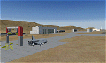
Australis is a joint private/military operations center located near Alice Springs in the Australian outback. It is the main base of operations of Aeroworks Technologies in the eastern hemisphere and conducts military missions in the far east of the globe. It acts very much the same as a normal AFB except that it is outside the US boundaries, and lies in a canyon very near the NSA Pine Gap facility. Occasionally some Russian and Chinese-built aircraft are trafficked through here. It also doubles as a spaceport and has shuttle recovery facilities similar to the ones in Railroad Valley. Scenery by Austin Gardner and Mike Vivaldi.
| Filename: | Australis_Operations_Center.zip |
| License: | Freeware |
| Added: | 14th August 2014, 01:28:31 |
| Downloads: | 824 |
| Author: | Austin Gardner |
| Size: | 27.7 MB |
| Category: Flight Simulator 2004 - Scenery | |
| Ft Collins-Loveland Muni 'KFNL' |
|
File Description:
FS2004 Scenery-Fort Collins-Loveland Municipal Airport, Colorado (KFNL) serves Fort Collins/Loveland and Larimer County and is owned by Fort Collins & Loveland. The airport has more than one runway. The longest is a paved runway extending 8500 feet. The facility is at an elevation of 5016 feet at a distance of about 9 miles from Fort Collins/Loveland. Fort Collins-Loveland Municipal Airport is mostly used for general aviation but is also served by one commercial airline, Allegiant Air. This scenery is not an attempt to be picture accurate. Requires the EZ scenery libraries. Read the readme file for list. Lago's FSE optional. By John B. Loney, Jr.
| Filename: | Ft_CollinsLoveland_Muni_KFNL.zip |
| License: | Freeware |
| Added: | 4th December 2006, 20:21:25 |
| Downloads: | 1,284 |
| Author: | John B. Loney, Jr. |
| Size: | 835.37 KB |
| Category: Flight Simulator 2004 - Scenery | |
| Air Force Flight Test Center, Detachment 3 (A.K.A. "Groom Lake" or "Area 51") |
|
File Description:
This set of files is a scenery enhancement for the Air Force Flight Test Center, Detachment 3, or AFFTC Det. 3, for short (more commonly, but erringly, refered to as "Area 51"). This package includes a faithfully reproduced digital rendition of the original area based upon the true footprint of the real-world airstrip near Groom Dry Lake, Watertown, Nevada.
This scenery is fully set up for all of your AI traffic needs, and is, I believe, the most accurate representation of the Groom Lake Facility to date. Enjoy flying the restricted skies of Dreamland Ranch! This package was designed for use with Flight Simulator 2004 ONLY.
| Filename: | Air_Force_Flight_Test_Center_Detachment_3_AKA_Groo.zip |
| License: | Freeware |
| Added: | 5th August 2006, 16:05:43 |
| Downloads: | 4,668 |
| Author: | Patrick Brodeur |
| Size: | 1.94 MB |
© 2001-2026 AVSIM Online
All Rights Reserved
Privacy Policy |