
Where Flight Simulation Enthusiasts Gather from Around the World!
AVSIM Library - Search Results

| Category: Flight Simulator 2004 - Scenery | |
| WIKD/WIOD Tanjung Pandan/Buluh Tumbang/H.A.S. Hanandjoeddin, Indonesia |

|
File Description:
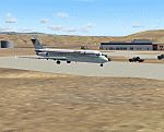
Googly scenery for WIKD/WIOD Tanjung Pandan/Buluh Tumbang/H.A.S. Hanandjoeddin,
Indonesia, based on Google Earth satellite data. It is a small domestic airport
serving the island of Belitung, located about 17 miles from the main town of the
island - Tandjungpandan. The island produces mainly tin and pepper but there are
some beaches that are generating tourist traffic too.
Flight Simulator 2004 has made no provision for any traffic at this airport and
this scenery seeks to redress the situation. The airport sees daily scheduled
traffic operated by Batavia Air and Sriwijaya Air.
The scenery does not purport to be ultra-accurate. Based on poor quality
satellite imagery from Google Earth, the layout is proportionally correct but the
added airport features, such as buildings, are built from default Microsoft objects
and add-on libraries so will not look exactly like the real thing.
You are not obliged to download and install any additional scenery libraries,
but to enjoy this scenery in its entirety, you may wish to. It will work fine,
with or without.
The ICAO code for this airport has recently changed from WIKD to WIOD. The included
files allow you to either retain the old code or optionally change the airport to
use the new one.
| Filename: | WIKDWIOD_Tanjung_PandanBuluh_TumbangHAS_Hanandjoed.zip |
| License: | Freeware |
| Added: | 22nd February 2008, 09:19:27 |
| Downloads: | 1,772 |
| Author: | John Hinson |
| Size: | 64.96 KB |
| Category: Flight Simulator 2004 - Scenery | |
| VGCB Cox's Bazar, Bangladesh |
|
File Description:
Googly scenery for VGCB Cox's Bazar, Bangladesh, a small domestic airport
serving the fishing town of the same name in the Bay of Bengal, to the
south of Chittagong. It boasts extensive sandy beaches which has allowed
tourism development. The unusual name comes from Captain Hiram Cox of the
British East India Company who was appointed Superintendent of the outpost
in the late 1700s. The airport, which was originally a Pakistan Air Force
base, sees domestic flights (mostly to/from Dhaka) operated by Hawker
Siddeley 748s, de Havilland Dash 8s and Fokker Fellowship aircraft of Biman
Bangladesh Airlines, GMG Airlines, United Airways and Zoom Airlines.
Flight Simulator 2004 has made no provision for traffic with only a runway
provided and this scenery seeks to redress the situation.
The scenery does not purport to be ultra-accurate. Based on high quality
satellite imagery from Google Earth, the layout is proportionally correct but the
added airport features, such as buildings, are built from default Microsoft objects
and add-on libraries so will not look exactly like the real thing.
You are not obliged to download and install any additional scenery libraries,
but to enjoy this scenery in its entirety, you may wish to. It will work fine,
with or without.
| Filename: | VGCB_Coxs_Bazar_Bangladesh.zip |
| License: | Freeware |
| Added: | 14th April 2008, 21:13:08 |
| Downloads: | 1,348 |
| Author: | John Hinson |
| Size: | 67.71 KB |
| Category: Flight Simulator 2004 - Scenery | |
| VGEG Chittagong/Shah Amanat International, Bangladesh |
|
Images related to this file:
File Description:

Googly scenery for VGEG Chittagong/Shah Amanat International (known as M A
Hannan until 2005) - an important airport in Bangladesh that is poorly provided
for in Flight Simulator 2004. These scenery files add taxiways, aprons,
buildings and other airport features, including the military area at the north
end and the general aviation ramps, so that you and your "AI" traffic can land,
taxi, park and take off in a realistic manner.
The city of Chittagong and its port are served regularly by jets ranging in size
from the Fokker 28 to the Douglas DC10 from operators like Air Arabia, Air Asia,
Biman Bangladesh Airlines, Oman Air, Thai Airways International, and turboprops of
GMG Airlines, United Airways and Zoom Airways.
The scenery does not purport to be ultra-accurate. Based on high-detail satellite
imagery from Google Earth, the layout is proportionally correct but the added
airport features, such as buildings, are built from default Microsoft objects
and add-on libraries so will not look like the real thing.
You are not obliged to download and install any additional scenery libraries,
but to enjoy this scenery in its entirety, you may wish to. It will work fine,
with or without.
[File re-uploaded at request of AVSIM]
| Filename: | VGEG_ChittagongShah_Amanat_International_Banglades.zip |
| License: | Freeware |
| Added: | 14th May 2010, 05:10:02 |
| Downloads: | 3,076 |
| Author: | John Hinson |
| Size: | 71.7 KB |
| Category: Flight Simulator 2004 - Scenery | |
| Cape Verde Islands Domestic Airports |
|
Images related to this file:
File Description:

Googlyafcads and simple scenery for five airports in the Cape Verde Islands, all
of which are served by regular domestic flights of TACV - Transportes Aereos de
Cabo Verde. Each of these has been "overlooked" by Microsoft in Flight Simulator
2004 and are provided with nothing other than a runway. These scenery files add
aprons, taxiways, buildings and other airport features to Flight Simulator's bland
representation and allow you and "AI" traffic to land, taxi, park and take off
in a realistic manner.
The airports represented are: GVBA Rabil, GVMA Maio, GVSF Sao Filipe, GVSN Preguica and GVSV Sao Pedro.
The scenery does not purport to be ultra-accurate. Based on high-detail satellite
imagery from Google Earth (except Sao Filipe), the layout is proportianally correct
but the added airport features, such as buildings, are built from default Microsoft
objects and add-on libraries so will not look like the real thing. Sao Filipe is
largely imaginary owing to poor quality of the satellite image, but has been created
to be similar to other airports of like size.
You are not obliged to download and install any additional scenery libraries,
but to enjoy this scenery in its entirety, you may wish to. It will work fine,
with or without.
[File re-uploaded at request of AVSIM]
| Filename: | Cape_Verde_Islands_Domestic_Airports.zip |
| License: | Freeware |
| Added: | 15th June 2010, 01:00:46 |
| Downloads: | 6,993 |
| Author: | John Hinson |
| Size: | 84.1 KB |
| Category: Flight Simulator 2004 - Scenery | |
| HCMI Berbera, Somalia |
|
Images related to this file:
File Description:
Googly scenery for HCMI Berbera, Somalia - an airport largely overlooked in
Flight Simulator 2004 with just a runway and tower provided at what is actually
the country's largest airport. At one time it had two active runways and a
strong military presence but today activity is limited to occasional
civilian flights. These scenery files add taxiways, aprons, buildings and
other airport features (and remove the non-existent tower that Microsoft
put there) so that you and your "AI" traffic can land, taxi, park and take
off in a realistic manner. This desert-surrounded airport is served three times per week by Douglas DC-9 jets of Kenyan airline African Express Airways.
The scenery does not purport to be ultra-accurate. Based on high-detail satellite
imagery from Google Earth, the layout is proportionally correct but the added
airport features, such as buildings, are built from default Microsoft objects
and add-on libraries so will not look like the real thing.
You are not obliged to download and install any additional scenery libraries,
but to enjoy this scenery in its entirety, you may wish to. It will work fine,
with or without. [File re-uploaded at request of AVSIM]
| Filename: | HCMI_Berbera_Somalia.zip |
| License: | Freeware |
| Added: | 29th May 2010, 09:26:33 |
| Downloads: | 1,317 |
| Author: | John Hinson |
| Size: | 62.07 KB |
| Category: Prepar3D V1-4 - Scenery | |
| ENRA - Mo I Rana Rossvoll Airport - Nordland, Norway |
|
Images related to this file:
File Description: The Mo i Rana airport, Rossvoll is a North Norwegian airport in the county of Nordland. It is located about ten kilometers northeast of the city Mo i Rana. Operator of the airport is the Norwegian state-owned company Avinor. The Mo i Rana Airport is currently served only by the Norwegian regional airline Wideroe. Scheduled flights go to an from Bodo, Bronnoysund, Mosjoen, Rorvik, Sandnessjoen and Trondheim. The P3D scenery is a partly rework of my FSX-ENRA scenery: Especially the apron lights are made completely new.
The environment of the airport is adapted by new landclasses. The airport has a photo background in two variants, covering all four seasons of spring,summer, autumn and winter. The buildings in this scenery come from the fantastic XPlane scenery of Bert alias "almosquito" who kindly gave me the permission to convert them for my FSX /P3D scenery. But there are also some objects taken from two very popular freeware libraries. If these libraries are not installed, several objects are not visible! Please have a look to the readme_enra.txt. The screenshots are taken from the FSX version. But the P3D version looks quite similar.
| Filename: | ENRA__Mo_I_Rana_Rossvoll_Airport__Nordland_Norway.zip |
| License: | Freeware |
| Added: | 2nd April 2019, 18:48:29 |
| Downloads: | 540 |
| Author: | Wolfgang Allers |
| Size: | 155.53 MB |
| Category: Flight Simulator 2004 - Scenery | |
| Beaver Municipal, Ok |
|
File Description:
FS2004 Scenery - Beaver Municipal (K44) is a small airport located in Beaver, Ok. It has 2 runways, one asphalt and the other grass. There is no fuel, maintenence nor attendents. The airport is publicly owned by the City of Beaver. Coordinates: 36-47-56.0930N/100-31-47.5350W ( 36.79891/-100.52987) Located 1 mile SW of Beaver, Oklahoma. Surveyed Elevation is 2491 feet MSL. Beaver Municipal was formerly known as Q44. PLEASE READ THE README FILE!!! Created with EZ Scenery. One non-defaut ai aircraft included. By John B. Loney, Jr.
| Filename: | Beaver_Municipal_Ok.zip |
| License: | Freeware, limited distribution |
| Added: | 4th June 2007, 19:29:29 |
| Downloads: | 440 |
| Author: | John B. Loney, Jr. |
| Size: | 712.49 KB |
| Category: Flight Simulator 2004 - Scenery Design | |
| LOM Images for fs9_custom_buildings_ss_1&.zip Collections |
|
File Description:
FS2004 LOM Library Objects Images. This archive contains an image import file containing thumbnails or image files for use with Library Object Manager (LOM) version 1.0+ program to manage FS2004 library objects and create scenery by ScruffyDuck Software, Jon Masterson. This is two image collections of 240 buildings. Requires LOM_100.ZIP and EZ Scenery library FS9_CUSTOM_BUILDINGS_SS_1.zip and FS9_CUSTOM_BUILDINGS_SS_1.zip. Also included is a set of higher resolution screenshots to upgrade those images imported into LOM. Higher resolution screenshots are suitable for printing an index or contact sheet of images. By Bryan Wallis.
| Filename: | LOM_Images_for_fs9_custom_buildings_ss_1zip_Collec.zip |
| License: | Freeware |
| Added: | 4th June 2006, 04:17:04 |
| Downloads: | 1,501 |
| Author: | Bryan Wallis |
| Size: | 5.9 MB |
| Category: Flight Simulator 2004 - Scenery Design | |
| LOM Images for fs9_jetways_ss_1&2.zip Collections |
|
File Description:
FS2004 LOM Library Objects Images. This archive contains two image import files containing thumbnails or image files for use with Library Object Manager (LOM) version 1.0+ program to manage FS2004 library objects and create scenery by ScruffyDuck Software, Jon Masterson. This is two image collections of 23 jetways. Requires LOM_100.ZIP and EZ Scenery library FS9_JETWAYS_SS_1.ZIP and FS9_JETWAYS_SS_2.ZIP. Also included is a set of higher resolution screenshots to upgrade those images imported into LOM. Higher resolution screenshots are suitable for printing an index or contact sheet of images. By Bryan Wallis.
| Filename: | LOM_Images_for_fs9_jetways_ss_12zip_Collections.zip |
| License: | Freeware |
| Added: | 4th June 2006, 04:18:03 |
| Downloads: | 1,490 |
| Author: | Bryan Wallis |
| Size: | 725.29 KB |
| Category: Flight Simulator 2004 - Scenery | |
| Joe Foss-Sioux Falls Regl KFSD |
|
File Description:
FS2004 Scenery-Joe Foss Field - Sioux Falls Regional Airport (KFSD) serves Sioux Falls and Minnehaha County and is owned by Sioux Falls Regional Airport Authority. The airport has more than one runway. The longest is a paved runway extending 8999 feet. The facility is at an elevation of 1429 feet at a distance of about three miles from Sioux Falls. South Dakota's 114th Fighter Group, nicknamed the Lobos, is stationed at Joe Foss Field, Sioux Falls, SD. Created entirely with EZ Scenery. New AFCAD2 file with AI flight plans. By John B. Loney, Jr.
| Filename: | Joe_FossSioux_Falls_Regl_KFSD.zip |
| License: | Freeware |
| Added: | 17th July 2006, 01:30:18 |
| Downloads: | 2,310 |
| Author: | John B. Loney, Jr. |
| Size: | 1.39 MB |
© 2001-2026 AVSIM Online
All Rights Reserved
Privacy Policy |