
Where Flight Simulation Enthusiasts Gather from Around the World!
AVSIM Library - Search Results

| Category: Flight Simulator 2002 - AFCAD Files | |
| Belg7000 |

|
File Description:
Scenery "Belg7000 V1.6" (1-Mai-2003) - Upgrade to FS2002 (Belgium 2003).
Airport : New EBSG-StGhislain - EBCV-Chièvres V1.1 - EBTY-Maubray - Cerfontaine(lake Eau d'Heure) and EBFS "by Early Bird".
The Belgium scenery where you can fly in "VFR" over 7000 Square Km area.
scenery : Mouscron-(Kortrijk)-Tournai-StGhislain-Mons-Lalouvière-Charleroi-Namur-Andenne-Huy-Liège-Verviers/Visé.
Beaumont-Chimay-Couvin-Cerfontaine "Eau d'Heure-artificial/barrier-lake", virelles-lake, Florennes-Dinant-Mettet-StGérard.
Nivelles-Genappe-Braine-l'Alleud-Tubize, Enghien-Ath-Chièvres-Renaix and more... Condé/Escaut-Quiévrechain (France).
Abbey : Maredsous, Floreffe, Bonne Espérance.
"Meuse valley", "Sambre valley", "Vesdre valley", and "Ourthe/Amblève valley" in Belgium.
Very very nice to fly at low altitude (1500-3000 ft) with an little aircraft.
By Fred. Bridoux
| Filename: | Belg7000.zip |
| License: | Freeware |
| Added: | 2nd May 2003, 12:25:19 |
| Downloads: | 1,883 |
| Author: | Fred. Bridoux |
| Size: | 419.78 KB |
| Category: Flight Simulator 2002 - Scenery | |
| Belg7000 |
|
File Description:
Scenery "Belg7000 V1.6" (1-Mai-2003) - Upgrade to FS2002 (Belgium 2003).
Airport : New EBSG-StGhislain - EBCV-Chièvres V1.1 - EBTY-Maubray - Cerfontaine(lake Eau d'Heure) and EBFS "by Early Bird".
The Belgium scenery where you can fly in "VFR" over 7000 Square Km area.
scenery : Mouscron-(Kortrijk)-Tournai-StGhislain-Mons-Lalouvière-Charleroi-Namur-Andenne-Huy-Liège-Verviers/Visé.
Beaumont-Chimay-Couvin-Cerfontaine "Eau d'Heure-artificial/barrier-lake", virelles-lake, Florennes-Dinant-Mettet-StGérard.
Nivelles-Genappe-Braine-l'Alleud-Tubize, Enghien-Ath-Chièvres-Renaix and more... Condé/Escaut-Quiévrechain (France).
Abbey : Maredsous, Floreffe, Bonne Espérance.
"Meuse valley", "Sambre valley", "Vesdre valley", and "Ourthe/Amblève valley" in Belgium.
Very very nice to fly at low altitude (1500-3000 ft) with an little aircraft.
By Fred. Bridoux
| Filename: | Belg7000.zip |
| License: | Freeware |
| Added: | 2nd May 2003, 12:27:01 |
| Downloads: | 2,944 |
| Author: | Fred. Bridoux |
| Size: | 1.29 MB |
| Category: Flight Simulator X - Scenery | |
| Flags and Signs |
|
File Description:
This package provides a little collection of flags and signs for scenery designers for FSX. The models have been developed with GMAX. Along with the textures the package includes the mdl files, and the XML files for the individual placement of the objects into a scenery. The bgl files are included as well.
The documentation (see pdf file in the ZIP) contains a step by step description on how to place the objects into the FSX scenery. A gauge for a proper positioning of the objects is part of the package.
CREDIT goes to:
Bob Familton for spending his time on review the package and the documentation.
Gary Mills, Robert Finnegan, Kevin Bryan, for the helpful package chplus.zip,
and Jim Robinson for the helpful package ch_pnl.zip .
| Filename: | Flags_and_Signs.zip |
| License: | Freeware |
| Added: | 18th February 2010, 04:16:51 |
| Downloads: | 638 |
| Author: | Dietmar Loleit |
| Size: | 1.71 MB |
| Category: Flight Simulator 2004 - Scenery | |
| Merrill Field PAMR 2016 V3 in Anchorage, Alaska, including the Fedex 727 |
|
Images related to this file:
File Description:
This V3 version of Merrill Field 2016 finally adds the Fedex 727 to Merrill Field, the error being totally mine but left as unreported by all but two of the downloaders. Testing on the computer of one of the reporting downloaders solved the problem, and revealed the requirement to have the aircraft "installed" on every user's computer. This was unknown by me, and not "testable" on my computer for obvious reasons. Which is why I need user input!?! Only 2 out of a total of around 500 downloaders? This is not a stand-alone scenery. Put the Fedex727.bgl into the scenery folder of your downloaded Merrill Field V2 and the 727 will be visible. You already have the textures in the scenery texture folder.
| Filename: | Merrill_Field_PAMR_2016_V3_in_Anchorage_Alaska_inc.zip |
| License: | Freeware, limited distribution |
| Added: | 3rd October 2016, 21:38:27 |
| Downloads: | 479 |
| Author: | Roger Wensley |
| Size: | 406.97 KB |
| Category: Flight Simulator 2004 - AI Aircraft | |
| AI Flying Boats package |
|
File Description:
AI Flying Boats package for FS9 By Derek Swanson.
This AI package simulates WWII patrol circuits within the British Isles by RAF Sunderlands and Catalinas and inlcudes:
1.Four AI Short Sunderland aircraft
2.Two AI Consolidated Catalina PBY5a aircraft
3.Two sets of AFCAD files for the water landing sites, one for FS9 default scenery and one for the additional FS9 UKVFR payware scenery
4.A set of AI flight plans within the British Isles
5.A set of revised flight dynamics for a user-flown Sunderland and Catalina
6.An E-Z scenery representation of Pembroke Dock
For full details of the above, and acknowledgement of the original authors of some components of this package, please see the README pdf file.
| Filename: | AI_Flying_Boats_package.zip |
| License: | Freeware, limited distribution |
| Added: | 21st December 2011, 11:42:39 |
| Downloads: | 854 |
| Author: | Derek Swanson |
| Size: | 21.27 MB |
| Category: Flight Simulator X - AFCAD Files | |
| Suncor Firebag, Fort McMurray, CYFI |
|
File Description:
This is a scenery made for Suncor Firebag aerodrome in Northern Alberta, just outside of Fort McMurray. The scenery includes the 1L airport NDB, however the ILS is not functional as of yet. I will fix that soon, until then the RNAV approaches for 17 and 35 are available if you have an RNAV capable aircraft. The scenery only includes the airport, not the surrounding oil fields.
FROM WIKIPEDIA:
"Fort MacKay/Firebag Aerodrome (IATA: YFI, ICAO: CYFI) is located 22 nautical miles (41 km; 25 mi) from the Firebag River, Alberta, Canada. The aerodrome was built to service the Firebag in-situ operation of Suncor Energy."
Runways: 17/35, 6890'
Navigation Aids: 1L NDB 400Hz, U/S ILS RWY 35
| Filename: | Suncor_Firebag_Fort_McMurray_CYFI.zip |
| License: | Freeware |
| Added: | 9th March 2021, 20:14:02 |
| Downloads: | 143 |
| Author: | Nathan Chetram |
| Size: | 4.48 KB |
| Category: Flight Simulator X - Scenery | |
| Chatham Islands: Updated Airports, Landclass, Water Data, and Flight Plans |
|
Images related to this file:
File Description:
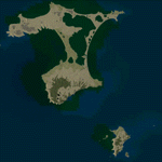
This project significantly updates New Zealand's Chatham Islands and includes more accurate coastlines, lakes, road and river data, as well as corrected landclass and a fully updated Chatham Islands/Tuuta Airport (NZCI). Napier (NZNR) aprons and terminal are also updated to more closely reflect the actual airport and accommodate Air Chathams, and the Pitt Island Airstrip (NZPI) is added to FSX. All updates were done in a manner which carefully aligned airport data with current satellite imagery. These airports are served by Air Chathams. Scenery was created using Airport Design Editor X v1.47.07, SBuilderX 3.13, and the FSX Object Placement Tool. Scenery objects were added and modified from stock FSX scenery to resemble as closely as possible the actual airports.
| Filename: | Chatham_Islands_Updated_Airports_Landclass_Water_D.zip |
| License: | Freeware |
| Added: | 8th July 2011, 21:44:02 |
| Downloads: | 1,674 |
| Author: | Carlyle Sharpe |
| Size: | 17.78 MB |
| Category: Flight Simulator X - Scenery | |
| EDTC Bruchsal |
|
Images related to this file:
File Description:
The airfield Bruchsal (ICAO: EDTC) is a special landing place in the city Bruchsal.
In addition to the use of the resident Luftsportverein Bruchsal, the place is also approved as a factory airfield of the company DG Flugzeugbau.
It has a grass runway: 12/30 - 500 by 30 metres (about 1,640 by 98 ft).
The scenery was created with a satellite picture of the airport, to match up all buildings, aprons, surroundings and so on, representing the most current state of EDTC as for the data that was available for the time the scenery got
created.
It contains ground textures for Summer and Winter (Spring/Fall use the Summer texture); autogen and default scenery objects of FSX plus a modified AFCAD file.
| Filename: | EDTC_Bruchsal.zip |
| License: | Freeware, limited distribution |
| Added: | 18th June 2018, 16:46:11 |
| Downloads: | 314 |
| Author: | Peregrine Simulations |
| Size: | 27.5 MB |
| Category: Flight Simulator 2004 - Scenery | |
| Ko Samui, Thailand (VTSM) v4.0 |
|
File Description:
Samui is a small, but busy airport on the island of Ko Samui. It is located in Southern Thailand, and is an exotic resort destination. In 1989 Bangkok Airways opened their own airport on the island, which decreased the travel time from Bangkok considerably. The airport is currently served by Bangkok Airways, although an occasional private aircraft will land here. This scenery is a detailed and accurate representation of this airport as it looks today. I consulted with several visitors to the airport, as well as the AIP for Thailand. Landsat imagery was used to modify the shoreline, and a custom landclass is included. Taxiway and parking areas were modified by using AFCAD2. This scenery is compatible with 3rd-party mesh scenery for Thailand.
| Filename: | Ko_Samui_Thailand_VTSM_v40.zip |
| License: | Freeware, limited distribution |
| Added: | 25th April 2004, 21:10:31 |
| Downloads: | 11,741 |
| Author: | Martin Strong |
| Size: | 5.34 MB |
| Category: Flight Simulator 2004 - Scenery | |
| UK Hospitals (Vol 1) |
|
File Description:
This scenery collection contains airfield data for 54 Helipad landing sites in Wales, Lancashire, Merseyside, Cheshire and Cumbria based on the information provided by the Confederation of Helicopter Ambulance Services. Information here http://www.chasuk.co.uk/Documentation/HospitalLandingSites/tabid/69/Default.aspx.
The scenery is intended to be used in FS2004 Century of Flight with Just Flight's VFR photographic VFR scenery installed. The height data from CHASUK has been ignored in favour of that obtained from the Just Flight default mesh.
I have started to add autogen trees etc. around some of the landing sites - but this takes a lot longer and so I'm issuing vol 1 first with autogen only added to a few of the sites in the Chester/Merseyside area.
| Filename: | UK_Hospitals_Vol_1.zip |
| License: | Freeware |
| Added: | 2nd April 2009, 16:44:10 |
| Downloads: | 1,100 |
| Author: | Russ McGinn |
| Size: | 231.54 KB |


© 2001-2026 AVSIM Online
All Rights Reserved
Privacy Policy |