
Where Flight Simulation Enthusiasts Gather from Around the World!
AVSIM Library - Search Results

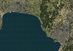
| Category: Flight Simulator X - Scenery | |
| Carrier CVN75_V2 North Sea |

|
File Description:
This is a update version of my scenery DL_CVN75.zip.
Changes in Version 2 of the cenery:
1.The Carrier model is now a private object and no longer part of the standard FSX object lib..
This allows the installation and registration in FSX scenery setting to be done like any
other addon objects.
The registration of the scenery in FSX below " Global, Generic & Vehicle Libraries" is no
longer required !!!!
2.Version 2 has more stuff on deck of the carrier.
3.The Number 75 is more accurate according to the real carrier.
4.The ILS frequencies ( e.g. GS) is more accurat adjusted in relation to the cable zone.
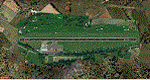
Scenery: Carrier Group North sea. Close to the Island of Sylt The Scenery includes: - The USS Carrier Harry Truman, CVN 75 with full function as an Airport with ILS approach capability.
F18-Fighters and a Navy-Heli on the Carrier. - 2 flying Helicopters over the Carrier. - 4 Navy-Destroyers escorting the Carrier. In addition to the Carrier-Group: - A Oilrig about 30 nm northwest from the Carrier. The Heli-Pat is a landable Platform !! - 2 moving Destroyer based on a "Boats Traffic Plan" which are moving around the group according to the time schedule in the plan.
| Filename: | Carrier_CVN75_V2__North_Sea.zip |
| License: | Freeware |
| Added: | 26th December 2008, 10:44:37 |
| Downloads: | 3,483 |
| Author: | Dietmar Loleit |
| Size: | 4.83 MB |
| Category: Flight Simulator 2004 - Scenery | |
| "Caiolo" Sondrio Airport, Valtellina, North Italy |
|
Images related to this file:
File Description:
In this airport reside AvioValtellina and VolaValtellina, as well as the operational base of the Health Service 118 and Mountain Rescue. It also base of the Aeroclub Sondrio with its Flight School VDS. Site at the beginning of the Valtellina, in Caiolo municipality (N46 09.0 E09 48.0), has an asphalt runway from 1050x23 mts, ground communication frequency 129.50; ICAO code: LILO. It is also enclosed the base of INAER Aviation, located in Colico-Piantedo (N46 08.18 E09 24.19 - code LIEI), that operates in Medical Emergency, rescue operations in the mountains and off-shore. Scenery realized on the real cooordinates of the airport (except for elevation) including the scenery of the heliport INAER Colico. Requires the use of the libraries' dva51 "and the system of vegetations "TreePlanter".
Enjoy!
A presentation video is available here.
| Filename: | Caiolo_Sondrio_Airport_Valtellina_North_Italy.zip |
| License: | Freeware |
| Added: | 25th October 2014, 11:52:25 |
| Downloads: | 856 |
| Author: | Aldo Della Vedova |
| Size: | 29.5 MB |
| Category: Flight Simulator X - Scenery | |
| NZWV - Waihi Beach Airfield, New Zealand |
|
Images related to this file:
File Description:
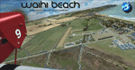
Waihi Beach (ICAO: NZWV) is a small airstrip north of Tauranga and near the small beach settlement of the same name, in the Bay of Plenty of New Zealand. It is a grass strip with offset thresholds giving usable landing lengths of 640m and 517m for RWY 13 and 31 respectively, a width of 55m and a group rating of 5. No night lighting or fuel is available. A very basic airstrip, there is only one recently built hanger and the airstrip is slowly being encroached on by
new housing developments. The airstrip itself is usually very sodden due to its low elevation but is a nice stop over for sightseeing from Tauranga and up the Coromandel peninsula.
The FSX model includes custom textures and models placed on a high resolution aerial image and a 15m mesh. It makes extensive use of items from the free VLC object libraries which are required to be installed (Available from www.vectorlandclass.co.nz Downloads menu). This scenery and
the VLC libraries have been funded by sales of VectorLandClass and although you do not need VLC to use it, your purchase helps further development.
| Filename: | NZWV__Waihi_Beach_Airfield_New_Zealand.zip |
| License: | Freeware, limited distribution |
| Added: | 1st November 2012, 10:01:38 |
| Downloads: | 1,006 |
| Author: | Tim Barnes / VectorLandClass |
| Size: | 11.13 MB |
| Category: Flight Simulator 2004 - Scenery | |
| Inyokern Airport, Inyokern CA. , USA - Version 3 |
|
Images related to this file:
File Description:
FS2004 Scenery for Inyokern Airport (KIYK). SORRY everyone there were some libraries and textures missing from the recent release. This package contains all missing objects and libraries and is a complete replacement for ANY of my Inyokern sceneries previously installed, no other download required. (Nestled on the sunny side of the southern Sierras, Inyokern is a great jumping-off place for hi desert adventures. Known for decades for it's great soaring spots, Inyokern itself is busy enough with an average of 80 flights a day including it's United/Skywest commuter flights and occasional military traffic from the nearby China Lake Naval Weapons Test Center. Geographically, the airport is situated in the high desert of Southern California, 100 miles east-northeast of the county seat in Bakersfield, 80 miles north-northeast of the Lancaster and Palmdale areas, and 120 miles north-northwest of San Bernardino. The airport itself covers 1,640 acres at an elevation of 2,457 feet, with three asphalt paved runways that can accommodate almost any class of civilian, commercial, or military aircraft. Inyokern Airport is served by commercial airlines connecting through Los Angeles International Airport.)
| Filename: | Inyokern_Airport_Inyokern_CA__USA__Version_3.zip |
| License: | Freeware, limited distribution |
| Added: | 10th November 2013, 23:32:02 |
| Downloads: | 2,056 |
| Author: | John Stinstrom |
| Size: | 6.36 MB |
| Category: Flight Simulator X - Scenery | |
| KSJT - San Angelo / Mathis Regional Airport - San Angelo, Texas |
|
Images related to this file:
File Description:
Custom built detailed terminal and control tower, hangars,
nearby buildings. US Customs building at north end. Added
fuel trucks and GSE.AI traffic file adds a US Customs Orion,
American Eagle flight to DFW, and some GA traffic. Additional
libraries required for some buildings and AI to show up (listed).
By Dan French.
| Filename: | KSJT__San_Angelo__Mathis_Regional_Airport__San_Ang.zip |
| License: | Freeware, limited distribution |
| Added: | 7th March 2014, 12:35:57 |
| Downloads: | 517 |
| Author: | Dan French |
| Size: | 301.54 KB |
| Category: Flight Simulator X - Scenery | |
| West Kansas Airfields 1 |
|
File Description:
Here are 23 smaller airfields in Western Kansas. They are all created using "native" FSX objects, so you don't need any additional libraries or textures. Not meant to be "photo-real", just fun to fly into and out of. Accurate runway and apron layouts. Complete listing in the "readme" file. More to come!
| Filename: | West_Kansas_Airfields_1.zip |
| License: | Freeware |
| Added: | 4th August 2008, 01:13:57 |
| Downloads: | 1,124 |
| Author: | Steve Ziegler |
| Size: | 82.04 KB |
| Category: Flight Simulator 2004 - Scenery Design | |
| Small Airstrip Objects SS FS9 scenery objects |
|
File Description:
As far as I know, this is the most comprehensive collection to date of small airport scenery objects. More importantly, these are, for the most part, objects that have never before been made available. Most of these objects were suggested by Rob de Vries in the Netherlands, who also provided me with many useful photos on which to base the designs. My thanks to Rob.
Objects include:
* Runway end and side markers in a variety of materials and colors.
* Ground markings of various kinds, including a compass rose, runway & airport closed indicators, and general aviation parking guides.
* Animated wind T, tetrahedron, and wind sock (wind sock by Jörg Dannenberg).
* Segmented circles in two styles and colors, with runway and pattern indicators. (For information on how to use segmented circles, see enclosed FAA document circles.pdf.)
* Weathered asphalt and concrete surfaces.
Most of the objects come in new and weathered versions. In addition, the segmented circles and wind indicators come with and without night lighting. These are standard FS9 scenery objects and can be placed using Instant Scenery or other programs that are able to use FS9 scenery libraries.
| Filename: | Small_Airstrip_Objects_SS_FS9_scenery_objects.zip |
| License: | Freeware |
| Added: | 12th November 2007, 08:17:15 |
| Downloads: | 5,019 |
| Author: | Sidney Schwartz |
| Size: | 3.97 MB |
| Category: Flight Simulator 2004 - Scenery | |
| Death Valley Badwater landclass |
|
File Description:
FS2004 Death Valley Badwater landclass
(works probably in FS2002 too)
A small landclass addon for Death Valley,
California.
Badwater is the lowest place in USA and there
is a white, dry saltlake across the bottom
of the valley.
I used EZ-landclass and year-around snow
for this, it stays white even in the
hottest sun !
| Filename: | Death_Valley_Badwater_landclass.zip |
| License: | Freeware |
| Added: | 8th October 2005, 22:39:50 |
| Downloads: | 1,897 |
| Author: | Per Kruuse |
| Size: | 121.16 KB |
| Category: Flight Simulator 2004 - Scenery | |
| Santorini LGSR Big Scenery 2012 (airport and full island scenery) |
|
Images related to this file:
File Description:

This FS2004 project is about the greek Santorini island (located in the Aegean Sea 200 km southeast from Greece's mainland) and contain two main scenery parts:
1) the "Santorini (Thira) International Airport" (Iata: JTR, Icao: LGSR) where you'll find all buldings (airport and close sourroundings buildings), hundred of custom made detailed objects, static and animated vehicles, animated scenery parts and various effects.
2)the Santorini island scenery where you'll find real hand-made landmarks (churches, factories, windmills,harbors and more), boats/ferries, completely redesigned landclasses with custom (seasonal+night) ground textures, coastlines, roads, main towns with custom greek textures, extreme autogen density and a lot of objects.
Every scenery part (frame-rate friendly thanks to the low poly design) has photoreal textures and everything is placed in the right position (wich was found at spring 2012) and in according to the satellite image.English extendet handbook is included. Watch the screenshot and the demo video on the Albysim youtube chanel and enjoy all scenery features (in this free/demo edition some features are limited).
| Filename: | Santorini_LGSR_Big_Scenery_2012_airport_and_full_i.zip |
| License: | Check within download |
| Added: | 4th November 2012, 13:13:55 |
| Downloads: | 4,709 |
| Author: | Albysim Scenery Design (Alberto Di Bolzano) |
| Size: | 35.43 MB |
| Category: Flight Simulator X - Scenery | |
| Macedonia 2014 OpenStreetMap Scenery |
|
Images related to this file:
File Description:
OSM based scenery of Macedonia.
Data from OSM:
Roads, railways, lakes, rivers, streams.
Land class is modified for largest cities, towns and villages.
| Filename: | Macedonia_2014_OpenStreetMap_Scenery.zip |
| License: | Freeware |
| Added: | 18th April 2014, 07:03:34 |
| Downloads: | 541 |
| Author: | Sami Toronen |
| Size: | 1.67 MB |
© 2001-2026 AVSIM Online
All Rights Reserved
Privacy Policy |