
Where Flight Simulation Enthusiasts Gather from Around the World!
AVSIM Library - Search Results

| Category: Flight Simulator 2004 - Miscellaneous Files | |
| Active Approach - PHNL (Honolulu Intl Honolulu, Hawaii) |

|
File Description:
As most know the Approach and Final (VMC) for AI Traffic in FS9 is a straight in type landing and does not always consider high terrain at airports. This is do to the way that the coding is written in FS9 and it puts limits on IFR arriving aircraft. If you open runways at certain airports the AI Traffic will fly directly through a mountain once it is established on Final for a runway. What you will see with my file is a different type approach used for the way I control AI Traffic in FS9. No longer do the AI Planes use a straight in approach when landing to the west at PHNL. My new AI Aircraft Approach coding for FS9 now uses a base leg approach so AI Traffic does not fly through the mountains. The Honolulu Control Tower will clear all AI Traffic (IFR FP) landing either on 26L and 26R as a straight in landing even though the offset to final is 30 degrees from the runway center line. The Control Tower will instruct the AI Planes landing on either 22L or 22R to fly a left base leg which is greater then a 45 degree offset and then the AI Planes will turn on a short 1.5 mile final. The left base approach to 22L and 22R runways is a 65 degree offset from the runway center line. My testing shows excellent behavior of the FS9 default models, PAI models and the Aardvark planes of all sizes to execute this new type of visual approach that I am now writting code for which supersedes the FS9 default straight in ATC hard code approach. Read the text file for all the default scenery enhancements (plus Jetways) added to PHNL along with a full understanding of how the new Approaches work *** 3rd Party Scenery Designers Special APProach bgl and a FS2004 Default Scenery AFCAD included ***
| Filename: | Active_Approach__PHNL_Honolulu_Intl__Honolulu_Hawa.zip |
| License: | Freeware, limited distribution |
| Added: | 16th March 2005, 04:10:43 |
| Downloads: | 5,606 |
| Author: | Jim Vile |
| Size: | 134.3 KB |
| Category: Flight Simulator 2004 - AFCAD Files | |
| Heydar Aliyev International Airport Baku Azerbaijan (UBBB) |
|
File Description:
UBBB - Heydar Aliyev International Airport, Baku, Azerbaijan for FS9 default scenery. Formerly named 'Bina'. Featuring:- "Crosswind active runways" (simultaneous approaches on 16/34 and 18/36) to reduce AI go-arounds. Rw16/34 is closed to takeoffs due to poor taxiway access at the 16 end. The missing ILS/DME is fitted to runway 18/36. Special, additional bgl (compiled XML) to activate the AFCAD-added ILS so that ATC offers the ILS approach and vectoring to the user and AI aircraft, instead of just the visual approach. New cargo ramp added. Parking positions and gate numbers revised in accordance with a recent chart. A third bgl to move the Airport beacon off the ramp it was sat on and remove an object blocking the taxiway to the new cargo spaces. Nearby airbases "Baku Kala" (UB18) and Nasosnaya (UB0C) thrown in as optional extras. XML source files are included but not required for functionality. The AFCAD2 files are unsuitable for use in FSX.
| Filename: | Heydar_Aliyev_International_Airport__Baku_Azerbaij.zip |
| License: | Freeware, limited distribution |
| Added: | 21st November 2006, 11:07:20 |
| Downloads: | 1,017 |
| Author: | Mark S. Cherry |
| Size: | 25.18 KB |
| Category: Flight Simulator 2004 - Flight Plans | |
| SIDSTARS Cycle 0711 Collection |
|
File Description:
PMDG SIDSTARS Cycle 0711 (25Oct-22Nov) Procedures based on FAA Digital Aeronautical Information and Digital Terminal Procedure Publications. This collection includes 63 locations (+ indicates added since last cycle; * indicates major rewrite): KABQ KATL KAUS KBNA KBOS KBUF KBUR KBWI KCLE KCLT KCMH KCVG KDAL KDCA KDEN KDFW KDTW KEWR KFLL KGEG KHOU KIAD KIAH KIND KJFK KLAS KLAX KLGA +KLGB KMCI KMCO KMDW KMEM KMIA KMSP KMSY KOAK KONT *KORD KPBI KPDX KPHL KPHX KPIT KPVD KRDU KRNO KSAN KSAT KSDF KSEA KSFO KSJC KSLC KSMF KSNA KSTL KTPA KTUS PANC PHNL PHOG TJSJ. There a several changes to note: The RNAV STARs at KATL have been revised providing downwind tracks North and South of the airport for approaches to all runways; KIAD's PRYME RNAV DP has been deleted with no replacement taking them back to vectors-only; KLAX has a new STAR RIIVR that is similar to CIVIT and KSLC has a new set of RNAV STARs for all arrivals. For PMDG Only.
| Filename: | SIDSTARS_Cycle_0711_Collection.zip |
| License: | Freeware, limited distribution |
| Added: | 20th October 2007, 23:11:19 |
| Downloads: | 713 |
| Author: | Dan Downs |
| Size: | 382.77 KB |
| Category: Flight Simulator X - Scenery | |
| LGKA-Aristotelis Airport, Greece |
|
Images related to this file:
File Description:
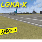
LGKA - ADE enhanced scenery, Aristotelis Airport Greece. FSX scenery only, no big frame-hits - uses only default scenery objects.
One night this winter, I tried to land at LGKA. The regional airport Aristotelis, since I was on my way to Turkey and finally Israel.
When I was cleared to land, with a visibility around 1 or 2 N.miles I couldn't find the airport even though the VOR and NDB guided me straight to it.
Suddenly the airport appeared as I passed over it. There was no lighting at the airport even though charts promised me lit runways. The airport was barren, desolate. So that meant work! With the aid of ADE I added runway lighting, added some buildings, a fuel trigger and other stuff to have a nice airport in NW Greece. Not completely 100% accurate where buildings are concerned, but just fun. It 's yours. if you want it. AVSIM upload only
| Filename: | LGKAAristotelis_Airport_Greece.zip |
| License: | Freeware, limited distribution |
| Added: | 13th April 2010, 18:18:50 |
| Downloads: | 3,064 |
| Author: | Joost Visser |
| Size: | 319.25 KB |
| Category: Flight Simulator 2004 - Gauges | |
| RwyInfo 2 Data Update |
|
File Description:
The purpose of this download is to allow you to update the data used by Ernie Alston's Runway Info gauge (RwyInfo version 2.0, available from http://www.fsbuild.com/rwyinfo/). This is an excellent little gauge that allows you to retrieve, through a gauge on your panel, information for all the runways at an airport (selected by ICAO code), and optionally automatically load frequency and course for an ILS into your NAV1 radio and MCP. However the usefulness of the gauge is somewhat restricted by the fact that it comes with a text database of 'info' to be displayed, and does not include any method for updating this info, other than by going into the text file and typing changes yourself (carefully, character by character). This is not really a practical method of getting the data to match your current FS configuration. What I have done is created a little utility that will create a new text database for the RwyInfo 2 gauge, based on your current scenery configuration.
| Filename: | RwyInfo_2_Data_Update.zip |
| License: | Freeware |
| Added: | 30th October 2011, 21:24:00 |
| Downloads: | 471 |
| Author: | Ken Leedham |
| Size: | 4.39 KB |
| Category: Flight Simulator 2004 - Gauges | |
| RwyInfo 2 Data Update Version 2 |
|
File Description:
The purpose of this download is to allow you to update the data used by Ernie Alston's Runway Info gauge (RwyInfo version 2.0, available from http://www.fsbuild.com/rwyinfo/). This is an excellent little gauge that allows you to retrieve, through a gauge on your panel, information for all the runways at an airport (selected by ICAO code), and optionally automatically load frequency and course for an ILS into your NAV1 radio and MCP. However the usefulness of the gauge is somewhat restricted by the fact that it comes with a text database of 'info' to be displayed, and does not include any method for updating this info. This is Version 2 of this utility - the first version was uploaded a couple of weeks ago. The first version is not required to use this version. This version fixes some problems with the display of new airports and runs much faster than the original version.
| Filename: | RwyInfo_2_Data_Update_Version_2.zip |
| License: | Freeware |
| Added: | 17th November 2011, 07:55:54 |
| Downloads: | 728 |
| Author: | Ken Leedham |
| Size: | 5.73 KB |
| Category: Flight Simulator 2004 - Scenery | |
| Notre Dames des Landes Airport - Nantes, France |
|
Images related to this file:
File Description:
Notre Dames des Landes Airport (Nantes, France) includes only the AFCAD file with the runways, the apron, parking stands and the taxiways. This does NOT include the buildings.
In February 2008, approval was finally given for the construction of a new airport near Nantes in Brittany by the French ministry for ecology and sustainable development and the Conseil Etat
(the public utility decree was signed on 10 February 2008). The new airport has been under discussion for the last 30 years and is expected to become reality by 2017 (construction was scheduled to begin in 2012 !...).
The new two-runway Notre-Dame-des-Landes Airport, which is also known as the New Nantes Atlantique Airport and the roport du Grand Ouest (greater west) will be situated 30km northwest of the City of Nantes, Loire-Atlantic,
which is 90km south of Rennes and will have the effect of alleviating low-level flying over the city thus reducing noise pollution.
| Filename: | Notre_Dames_des_Landes_Airport__Nantes_France.zip |
| License: | Freeware |
| Added: | 8th April 2014, 17:00:19 |
| Downloads: | 307 |
| Author: | Nicolas Neveu |
| Size: | 437.34 KB |
| Category: Flight Simulator 2004 - Scenery | |
| Hawk Logging, for Holger Sandmann's scenery |
|
Images related to this file:
File Description:
This is a logging camp, on Admiral Island at the northern end of Chatham Strait in southern Alaska, around 30 miles south of Juneau. It is marked on the chart of the area; if you are chartless then there is a section of the chart included here. This scenery is designed specifically for use in the Tongass Fjord scenery (or Glacier, or Misty? I don't remember now which area it is in!) and probably does not work with just Ultimate Terrain; I haven't tried it. The camp has an identifying code so it will show up on a gps as PELC but there is no interaction with atc as there are no designated water runways; PELC on the GPS just acts as a waypoint. There will be further posts for use with Tongass Fjords, Misty Fjords, and Glacier Bay, and I still find these scenery areas by Holger and his crew the most satisfying in FS9.
| Filename: | Hawk_Logging_for_Holger_Sandmanns_scenery.zip |
| License: | Freeware, limited distribution |
| Added: | 8th November 2014, 22:42:24 |
| Downloads: | 319 |
| Author: | Roger Wensley |
| Size: | 12.37 MB |
| Category: Flight Simulator 2004 - Scenery | |
| PACD - Cold Bay - Aleutian Islands, Alaska, USA |
|
Images related to this file:
File Description:
Cold Bay is in the eastern third of the Aleutian chain of islands in Alaska, around 175 miles east of Dutch Harbor. The small town has a population of just over 100 and is in existance solely because of the airport with its long runways, one just over 6,000 feet and the other over 10,000 feet and with an ILS. Goods are flown here for local redistribution. The airport was originally built to this size for use in WW2 and there are still quonset huts from this time visible in the area, though the majority of the rough-and-ready housing has now been cleared away. There are scheduled flights by Grant Aviation to neighbouring local airfields and flights to and from Anchorage by Peninsula Air (included in the AI posted with Adak) and Grant Aviation have space attached to their hangar that serves as a terminal. The Coastguard also make use of Cold Bay.
| Filename: | PACD__Cold_Bay___Aleutian_Islands_Alaska_USA.zip |
| License: | Freeware, limited distribution |
| Added: | 21st January 2015, 10:01:50 |
| Downloads: | 425 |
| Author: | Roger Wensley |
| Size: | 4.88 MB |
| Category: Flight Simulator X - Scenery | |
| RAF Snetterton Heath - Norfolk, England |
|
File Description:
RAF Snetterton Heath is a former Royal Air Force station located south east of the A11, 6 miles (9.7 km) south west of Attleborough, Norfolk, England.
RAF Snetterton Heath airfield was constructed in 1942 to Class-A specifications. Originally thirty-six hardstandings of the "frying pan" type were constructed as when work started, the base was intended for Royal Air Force (RAF) use. When re-scheduled for the United States Army Air Forces (USAAF), the number was increased to fifty, all of them being on the south and eastern side of the airfield as a railway line and the A11 road restricted dispersed locations.
With the end of military control Snetterton Heath was closed and privately purchased in 1952 with a view to utilizing the runways and perimeter tracks as a motor racing circuit. The first motor cycle meeting was held in 1953 and the first motor races the following year. Source: Wikipedia.
| Filename: | RAF_Snetterton_Heath__Norfolk_England.zip |
| License: | Freeware |
| Added: | 22nd January 2016, 16:10:44 |
| Downloads: | 173 |
| Author: | Terry Boissel |
| Size: | 1.43 MB |


© 2001-2026 AVSIM Online
All Rights Reserved
Privacy Policy |