
Where Flight Simulation Enthusiasts Gather from Around the World!
AVSIM Library - Search Results

| Category: Flight Simulator 2004 - Panels | |
| 737, 747 or 757 Panel Built-in GPS and Throttle |

|
File Description:
Fully functional panel for your favorite Boeing Airliner that has built in GPS, Radio and Throttle into the panel!
Very easy to install.
| Filename: | 737_747_or_757_Panel_Builtin_GPS_and_Throttle.zip |
| License: | Freeware |
| Added: | 10th August 2004, 16:18:12 |
| Downloads: | 15,365 |
| Author: | Randy Oldfield |
| Size: | 645.67 KB |
| Category: Prepar3D V1-4 - Scenery | |
| Bloukrans and Storms River (Paul Sauer) bridges – South Africa |
|
Images related to this file:
File Description:
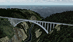
The Bloukrans and Paul Sauer (over the Storms river) bridges are on the N2 highway between Plettenberg Bay and Port Elizabeth on the scenic garden route in the Eastern Cape, South Africa. I made the custom scenery to try some Blender techniques using the P3D 4.5 SDK and tested it in P3D V5 using the ORBX Africa LC and Pilots NG2020 mesh products (I included a fix for the default V5 mesh). You will find the world's highest commercial bungee jump from the Bloukrans bridge, 216m above the river below. Take off from FAPG and fly a heading of 95 degrees for 32 km to get to the Bloukrans bridge (just off the coast). Follow the highway further east for another 26 km to get to the 120m high Paul Sauer bridge, where I included some additional eye candy.
| Filename: | Bloukrans_and_Storms_River_Paul_Sauer_bridges__Sou.zip |
| License: | Freeware |
| Added: | 14th July 2020, 19:15:53 |
| Downloads: | 180 |
| Author: | Johan Pienaar |
| Size: | 26.95 MB |
| Category: Flight Simulator 2004 - AI Aircraft | |
| Astra Airlines BAe-146-300 fleet and Summer 2010 FlightPlans |
|
Images related to this file:
File Description:

Astra Airlines (Greece) Fernando Martinez (FMAI) BAe146-300 fleet (x2) repaints for AI traffic including scheduled flights taken from their website 'Su10' and 'representative' charter flights.
I have also updated my old 'SX-DIZ' texture as I had the starboard engine logo facing the wrong direction.
| Filename: | Astra_Airlines_BAe146300_fleet_and_Summer_2010_Fli.zip |
| License: | Freeware |
| Added: | 27th July 2010, 22:31:45 |
| Downloads: | 7,371 |
| Author: | Billy Rutherford |
| Size: | 1.09 MB |
| Category: Prepar3D V1-4 - Scenery | |
| Prepar3d 1 2 3 4 blue haze and clouds makeover |
|
Images related to this file:
File Description:
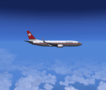
Sky effects remake with more realistic blue haze and recoloring of dark thunderstorms as in reality. No frame rate impact, suitable for p3d1 1 2 3 4 4.5 and (maybe 5 test it yourself)
Also suitable for HDR so you can also adjust intensity.
do not use other tools to adjust lights and shadows. Use only hdr default if necessary
| Filename: | Prepar3d_1_2_3_4_blue_haze_and_clouds_makeover.zip |
| License: | Freeware |
| Added: | 18th December 2020, 04:48:16 |
| Downloads: | 208 |
| Author: | Massimo Grassi |
| Size: | 8.17 MB |
| Category: Flight Simulator 2004 - Scenery | |
| EGGP VFR Landmarks - Jaguar Halewood and Local Factories Ver 1.0 |
|
File Description:
This is the seventh in a series of individual landmark sceneries for use while VFR flying in the area of Liverpool John Lennon Airport (EGGP). This version has been produced using Gmax and the FS2004 Scenery SDK. Therefore it is only compatible with FS2004, sorry! The scenery is aligned to the Visual Flight / Getmapping VFR Scenery published by Just Flight. However, it is also compatible with the FS2004 default scenery.
This scenery has been designed to compliment the Liverpool John Lennon Airport Scenery also by DerboSoft.
| Filename: | EGGP_VFR_Landmarks__Jaguar_Halewood_and_Local_Fact.zip |
| License: | Freeware |
| Added: | 16th November 2005, 23:04:02 |
| Downloads: | 4,601 |
| Author: | Paul Derbyshire |
| Size: | 199.58 KB |
| Category: Flight Simulator 2004 - AI Flight Plans | |
| Netherlands Coast Guard and Netherlands Antilles & Aruba Coast Guard flightplans |
|
File Description:
Provided in this file are some fictional flightplans for the Coast Guard of the Netherlands and the Coast Guard of the Netherlands Antilles and Aruba. They fly two Dornier Do-228 aircraft based at Amsterdam Schiphol International Airport [EHAM] and two DeHavilland Dash-8 aircraft based at Curaçao Hato International Airport [TNCC].
| Filename: | Netherlands_Coast_Guard_and_Netherlands_Antilles__.zip |
| License: | Freeware |
| Added: | 12th May 2008, 19:55:22 |
| Downloads: | 966 |
| Author: | Peter Bos |
| Size: | 3.59 KB |
| Category: Flight Simulator X - AI Aircraft | |
| Braathens SAFE (South American and Far East) Boeing 737-200 |
|
Images related to this file:
File Description:
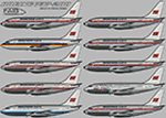
Braathens SAFE (South American and Far East) Boeing 737-200 for retro AI traffic, with 10 variants, utlizing the FAIB 737-200 model set. This package is for FSX/P3D only with DDS DXT5 textures. Aircraft model and master paint kit by Erez Weber, repaints by Michael Pearson.
| Filename: | Braathens_SAFE_South_American_and_Far_East_Boeing_.zip |
| License: | Freeware |
| Added: | 3rd September 2019, 19:45:25 |
| Downloads: | 219 |
| Author: | Michael Pearson |
| Size: | 7.73 MB |
| Category: Flight Simulator 2004 - Scenery | |
| FS2004 Ernest Harmon Air Force Base and Stephenville Airport CYJT |
|
File Description:
FS2004 Scenery--Ernest Harmon Air Force Base and Stephenville Airport (CYJT), Newfoundland, 1957-62. Originally built to facilitate the transport of US aircraft to Europe during the Second World War, during the Cold War Harmon was the biggest US base outside the USA. Like nearby Gander it was a vital refuelling point for transatlantic crossings, but also an important part of the defences against the threat of Soviet bombers carrying muclear weapons attacking the USA via the North Pole. F-89 Scorpions and then F-102 Delta Daggers were based there, and this download includes F-89s especially made for this scenery by David Wooster. It also has custom landclass adjustments by Al Von Pingel and many custom buildings by Dan French. Flight plans are provided for 1957, 1959 and 1962, doing much to recreate this significant Cold War base as it really was. By Al Von Pingel, Dan French and Ken Lawson.
| Filename: | FS2004_Ernest_Harmon_Air_Force_Base_and_Stephenvil.zip |
| License: | Freeware |
| Added: | 10th October 2021, 17:08:19 |
| Downloads: | 213 |
| Author: | Al Von Pingel, Dan French and Ken Lawson |
| Size: | 23.96 MB |
| Category: Flight Simulator X - Scenery | |
| YCDN Corunna Downs Station and Old Corunna Downs RAAF (Closed) |
|
File Description:
Corunna Downs heritage listed RAAF Base was a secret airfield located in scrub and spinifex country, about 16 kms south west of Marble Bar, the hottest part of the "The Pilbara" area of Western Australia. Not a very ideal place to have a tent city. Today there are very few reminders of the once busy airfield. One can see some crumbling foundations and half filled post holes. 73 OBU operated the Corunna Downs airfield which comprised two intersecting bitumen runways, now regressed and graded occasionally. One ran approximately north-south, 5,000 feet in length while the other ran approximately east-west, 7,000 feet in length. Both runways were approximately 150 feet wide. A 50 foot wide taxiway linked the northern end of the north-south runway to the western end of the east-west runway. Approximately 20 camouflaged revetments to disperse aircraft to minimise bomb damage were constructed at Corunna Downs. Permission is required for landing and there may be vegetation on the strip if not graded recently. No cones or windsock so be careful. Corunna Downs Homestead is also heritage listed and consists of graded strips and homestead complex. Start points are at the homestead and the RAAF base is to the west. REQUIRES Blencowe_LibraryKit.zip
REQUIRES blencowe_librarykit_309494.zip (Available HERE)
| Filename: | YCDN_Corunna_Downs_Station_and_Old_Corunna_Downs_R.zip |
| License: | Freeware |
| Added: | 25th February 2013, 08:59:42 |
| Downloads: | 283 |
| Author: | Alan Blencowe |
| Size: | 4.92 MB |
| Category: Flight Simulator X - Scenery | |
| YWSX - Westonia, Western Australia (Town, airstrip and Edna May Goldmine) |
|
File Description:
YWSX Westonia - Town, airstrip and Edna May Goldmine - Westonia, Tidy Town for 2009, is located in Western Australia's wheat belt, 316 kilometres east of Perth, 306 kilometres west of Kalgoorlie and 55 kilometres east of Merredin. Catalpa Resources Ltd Edna May Mine Operations boasts an impressive forward sold position of 352,316 ounces of gold at A$1,557.50 per ounce. At a hedge book weighted average gold price of A$1,400 per ounce Catalpa expects to realise an average cash operating margin of A$72 million per annum. Westonia "Airport" is a spartan sand strip with a windsock and no cones, visited by the RFDS monthly and used by one or two locals. Arrange to be picked up in advance or expect a 2k walk to the Edna May Tavern. REQUIRES Blencowe_LibraryKit.zip
REQUIRES blencowe_librarykit_309494.zip (Available HERE)
| Filename: | YWSX__Westonia_Western_Australia_Town_airstrip_and.zip |
| License: | Freeware |
| Added: | 28th February 2013, 17:07:52 |
| Downloads: | 283 |
| Author: | Alan Blencowe |
| Size: | 8.27 MB |


© 2001-2026 AVSIM Online
All Rights Reserved
Privacy Policy |