
Where Flight Simulation Enthusiasts Gather from Around the World!
AVSIM Library - Search Results

| Category: Flight Simulator 2004 - Aircraft Repaints, Textures and Modifications | |
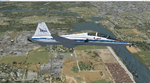
| Flexjet AI Traffic Package |

|
File Description:
This package adds Flexjet AI traffic to your Flight Simulator. Flexjet is Fractional Ownership leasing/charter company owned and operated by Bombardier. They fly Domestically and
Internationally. The Flexjet Fleet includes:
Learjet 31's, 40's, 45's, 60's, Challenger 300's, and 600's, and global expresses. Included in this package is the learjet 31, 45,
and 60, challenger 300 (with new paint scheme), and challenger 604. Aircraft models by Henry Tomkiewicz, Chuck Dome, Hrvoje Kovacevic,
and Andy Berry. Included is an Editvoicepack modification for the Flexjet callsign.
| Filename: | Flexjet_AI_Traffic_Package.zip |
| License: | Freeware |
| Added: | 3rd December 2004, 23:38:54 |
| Downloads: | 3,687 |
| Author: | Dan Fleming |
| Size: | 22.58 MB |
| Category: Flight Simulator X - Scenery Design | |
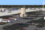
| (Version 2.0) KEFD -Ellington 2025 Refresh FSX (Circa 2006-2010)- Johnson Space Center Houston |
|
Images related to this file:
File Description:
Version 2.0 covers landclass across the entire greater Houston area, with a large increase in LOD. This version significantly tightens up and improves the landclass from version 1.0, and adds a vast amount of scenery objects that brings the Bay Area-KEFD area into the modern era. This improves and adds a highly accurate runway 17 approach with accurate placement of buildings and scenery around the year 2011-modern day. In addition, includes several new files including a new airport/helipad via Houston Clear lake regional airport, T41 La Porte Municipal and surrounding shipping ports, Kemah Boardwalk, and a giant improvement to Johnson Space Center Houston. Rundway 35 and Runway 22 landclass is significantly increased, and more accurate as well. You can fly an accurate VFR approach or set up an ILS for any one of KEFD's runways with ease with this improvement.List of Version 2.0 additions and changes: - I added a ton of scenery objects and tightened up the landclass at Johnson Space Center Houston- NASA Control Center--- Added Talon Park with T38s (via static objects)--- Added Gemeni V rocket and 747 for the shuttle transporter--- And a whole bunch of vegetation, new buildings, and tour buses.- Added Kemah boardwalk and several boat docks- Removed a TON of highrise textures and replaced with medium and large city suburb landclass.- Added Clear Lake regional Hospital with helipad and surrounding scenery by Walter Reed Park- Added El Jardin or "Bayport Container port" with several scenery objects and significantly tightened up landclass.-- Looks great when setting up ILS approach for RWY 22- Tightened up Bay Area BLVD landclass, "adding" University of Houston Clear Lake"-- UHCL was semi already present, just made it more pronounced.- Made Red Bluff road landclass super recognizable!-- Red Bluff road is used to set up VFR approach and or field break for RWY 22 and RWY 17 R.----- Its common to see private jets and the USAF doing a break along Red Bluff road.- Added First Baptist Church, and water tower to Pasadena Convention center- Made Fairmont Parkway pronounced with landclass- Added Houston Port Authority at Morgan's Point--- Another Landmark for the RWY 22 ILS approach, NASA religiously uses this to line up the 10 mile ILS.- Tightened up landclass at Village Grove East and along Fairmont Parkway- Added a TON of scenery objects and landclass corrections for approach of RWY 17 L and 17 R.---- Added Home Depot, Lowes, Walmart Super center, Guitar center etc.---- added South Main Baptist Church--- Bondy Jr High, Turner Elementary, and Pasadena Memorial High School--- Added Saint Luke's Hospital--- Added Hampton Inn Suites and HCA rehab hospital--- Added a ton to the container facility behind best buy and storage facility--- Added smaller churches on RWY 17 approach--- Added a ton of scenery at the base of RWY 17 R, i.e., concrete plant, containers, trucks-- Added gas stations on the corner of beltway 8 and genoa red bluff-- Significantly changed and tightened up landclass at the base of RWY 22 and RWY 17 L and 17 R-- Made several roads and Beltway pronounced------ This decision looks AWESOME at night, really adds demarcation to the roads.**All of this makes the RWY 17 approach super recognizable** RWY 22 approach landclass is much more accurate.- Significantly changed and tightened up landclass near southbelt ellington and interstate 45.- Added Grace Church-- I wanted to do San Jacinto College south, but seemed over kill at that point.- SIGNIFICANTLY tightened up landclass for RWY 35 approach and near baybrook mall.-- Along I45- Added TDECU stadium at the University of Houston Main Campus---- So you can practice flybys for Cougar games!- Added the Battleship at San Jacinto Monument- I also "borrowed" T41 La Porte Municipal's tower camera to make a SWEET view of KEFD.- I included landclass for Sealy Texas this time, as well as my significant enhancements of Austin, Texas greater area as well (optional, but recommended!)---------------------------------------------------------------------------Version 1.0 originally added:- Added the Johnson Space Center Houston, which is now greatly enhanced and blended.- San Jacinto Community College-Central- Pasadena Convention Center- Pasadena Water Treatment Facility- NASA Bouncy Lab- Pasadena Shopping center, now greatly enhanced and blended.- Baybrook Mall and other shopping spots.- Significant Landclass improvements across the entire greater Houston Area File also includes landclass and scenery improvements for the greater Austin, Texas Area (optional), KIAH, KDWH, and Sealy, Texas. Each of these projects combined covers roughly 15,000 square miles of landclass improvement. Allowing you to fly entirely from Houston to Austin, or Houston to San Antonio in accurate landclass. -Enjoy!DJN
| Filename: | Version_20_KEFD_Ellington_2025_Refresh_FSX_Circa_2.zip |
| License: | Freeware |
| Added: | 12th October 2025, 16:15:47 |
| Downloads: | 65 |
| Author: | Dan Nelson |
| Size: | 277.28 MB |
| Category: Flight Simulator 2004 - Aircraft Repaints, Textures and Modifications | |
| Cessna 172 - FFA "HB-CCT" |
|
File Description:
Repaint of the FFA C172 "HB-CCT" for the Flight1 Cessna 172. The aircraft is based in Altenrhein, Switzerland.
| Filename: | Cessna_172__FFA_HBCCT.zip |
| License: | Freeware |
| Added: | 20th December 2008, 20:34:42 |
| Downloads: | 392 |
| Author: | Dan Winiger |
| Size: | 4.52 MB |
| Category: Flight Simulator 2004 - Scenery | |
| Dallas Ft Worth Intl RNAV Support |
|
File Description:
This package includes 36 waypoints missing
from the original FS2004, but required to
fly current RNAV Departure Procedures (DP).
Current charts (effective through 2/16/2006)
are included for RNAV DPs only. A sample
flight plan for KDFW-KLAS is inlcuded.
| Filename: | Dallas_Ft_Worth_Intl_RNAV_Support.zip |
| License: | Freeware |
| Added: | 21st January 2006, 23:32:13 |
| Downloads: | 980 |
| Author: | Dan Downs |
| Size: | 1.11 MB |
| Category: Flight Simulator X - Scenery | |
| SCENERY for FSX ONLY ETAR Ramstein AB Germany |
|
Images related to this file:
File Description:
SCENERY for FSX ONLY ETAR Ramstein AB Germany
This is a very detailed version of Ramstein AB in Germany, with custom made buildings, hangars, and objects
on PhotoReal backgrounds. The terminal has transparent windows and interiors. The Landstuhl area with Medical Center is modeled.
Parking spots are coded for several MAIW packages (see readme). The unique style of ramplight at Ramstein was created here,
using video tutorials on making ground light splashes and refracted light "in-the-air". Various common libraries required as
outlined in the readme. Some issues as outlined in readme.
Dan French
| Filename: | SCENERY_for_FSX_ONLY_ETAR_Ramstein_AB_Germany.zip |
| License: | Freeware, limited distribution |
| Added: | 12th July 2022, 18:23:13 |
| Downloads: | 638 |
| Author: | Dan French |
| Size: | 157.77 MB |
| Category: Flight Simulator X - Scenery | |
| KLEX - Bluegrass Airport - Lexington, Kentucky - USA |
|
Images related to this file:
File Description:

This FSX (only) scenery is for Bluegrass Airport in Lexington, KY. Custom built terminal, hangars, Bluegrass Aviation Museum, TAC Air FBO, control tower, and appropriate landclass. Additional models provide scenery for Keeneland Racetrack and Calumet Farm on the approach to Rwy 22. The airport design features the newly separated runways and general aviation area. For additional enjoyment, a number of landmark buildings are modelled in downtown Lexington and the University of Kentucky campus.
By Dan French.
| Filename: | KLEX__Bluegrass_Airport__Lexington_Kentucky__USA.zip |
| License: | Freeware, limited distribution |
| Added: | 10th September 2015, 01:04:56 |
| Downloads: | 1,382 |
| Author: | Dan French |
| Size: | 9.06 MB |
| Category: Flight Simulator 2004 - Scenery | |
| Mc Carran International Airport, Las Vegas, Nevada (KLAS) Instrument Approach Update |
|
File Description:
The package provides current approach procedures including ILS RWY 1L not included in FS9.1. Recent charts (eff thru 2/16/06) are included and source file for bglcomp for use by others detailing the scenery. No scenery except updated Runway 1 Left is included. This updates the maps shown by FS GPS to be flow in accordance with current IAPs.
| Filename: | Mc_Carran_International_Airport_Las_Vegas_Nevada_K.zip |
| License: | Freeware |
| Added: | 2nd February 2006, 03:01:31 |
| Downloads: | 1,710 |
| Author: | Dan Downs |
| Size: | 868.78 KB |
| Category: Flight Simulator 2004 - Scenery | |
| Mc Carran International Airport, Las Vegas, Nevada (KLAS) RNAV Support |
|
File Description:
This package includes 29 waypoints missing from the original FS2004, but required to be able to fly current RNAV procedures such as STARs (Standard Terminal Arrival Routes) or DP (Departure Procedures) at KLAS. Recent charts (effective through 1/19/2006) are included for the STAR, DP and RNAV (GPS) Approaches.
| Filename: | Mc_Carran_International_Airport_Las_Vegas_Nevada_K.zip |
| License: | Freeware |
| Added: | 21st January 2006, 23:32:10 |
| Downloads: | 1,689 |
| Author: | Dan Downs |
| Size: | 1.66 MB |
| Category: Flight Simulator 2004 - Flight Plans | |
| PMDG SIDSTARS Cycle 0609 Collection |
|
File Description:
PMDG SIDSTARS Procedure files by Dan Downs for current (31Aug06-28Sep) cycle. Source for
all changes and additions is FAA NACO Digital Terminal Procedures charts. Most of these
files are based on earlier work by Terry Yingling, with much appreciation; however, I
have started developing my own procedures and these will include useful information in
the header of each text file, including DP and STAR charts to assist in selecting procedures. The latest of these is KHOU; also, KFLL and KONT have been added to the collection since the last cycle. This collection includes the following 33 locations:
KABQ KAUS KBNA KBWI KCMH KDAL KDEN KFLL KGEG KHOU KLAS KLAX KMCI KMCO KMDW KMSY KOAK KONT KPDX KPHL KPHX KRDU KRNO KSAN KSAT KSEA KSJC KSLC KSMF KSNA KSTL KTPA KTUS
| Filename: | PMDG_SIDSTARS_Cycle_0609_Collection.zip |
| License: | Freeware, limited distribution |
| Added: | 30th August 2006, 03:03:56 |
| Downloads: | 969 |
| Author: | Dan Downs |
| Size: | 136.87 KB |
| Category: Flight Simulator X - AFCAD Files | |
| GCFV (corrected) - Fuerteventura, Spain |
|
File Description:
This AFCAD file changes only the elevation of the airport from 140.82 meters to 20 meters which visually seems to be a good compromise with the FSX default scenery. Note: In the original submission of this airport to the AVSIM Library, the GCFV_ADE_DKR_ALT file was omitted.
| Filename: | GCFV_corrected__Fuerteventura_Spain.zip |
| License: | Freeware |
| Added: | 23rd February 2009, 21:14:32 |
| Downloads: | 1,338 |
| Author: | Dan Reynolds |
| Size: | 5.42 KB |
© 2001-2026 AVSIM Online
All Rights Reserved
Privacy Policy |