
Where Flight Simulation Enthusiasts Gather from Around the World!
AVSIM Library - Search Results

| Category: Navigation and ATC - Navigation | |
| Papua New Guinea charts 3 of 3 |

|
Images related to this file:
File Description:
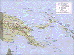
Re-upload. Calibrated for FSMap, but scanned images can be used in other map software, such as FSM Moving Map (FSMMM) by Rana Hossain. Chart source: Topographic Maps U.S. Army Map Service, Series T504, original scale 1:250,000, date 1964-. Courtesy of the University of Texas Libraries, The University of Texas at Austin. Missing: I could not find equivalent charts for New Britain; for this island, a lower-quality chart is included.
| Filename: | png_charts_3.zip |
| License: | Freeware |
| Added: | 5th June 2010, 05:26:20 |
| Downloads: | 514 |
| Author: | David Wilson-Okamura |
| Size: | 35.91 MB |
| Category: Flight Simulator 2004 - Miscellaneous Files | |
| Boeing 737-600/700 Charts & Tables V2.0 |
|
File Description:
This is my second version of the Boeing 737-600/700 Charts & Tables. This version has been updated and results in a "look" just like the real thing. Also a document you can't mis in your cockpit during a flight. Extremely useable charts are included, like: Take-off speeds on dry and wet runways, V1 + VR + V2 adjustments, Long-range cruise trip fuel and time, Operating limitations, weight limitations and general system information. All information included is applicable before, during and after the flight. The whole document consists of 4 pages which can easily be printed out. Also look for my "Boeing 737NG Advanced Checklist" which makes the whole thing complete.
| Filename: | boeing_737_charts_&_tables_v2.zip |
| License: | Freeware |
| Added: | 16th November 2003, 22:20:22 |
| Downloads: | 3,027 |
| Author: | Marcel Venema |
| Size: | 84 KB |
| Category: Flight Simulator X - Miscellaneous Files | |
| Piaiggio P.180 Avanti II Performance Charts |
|
Images related to this file:
File Description:

FS9_FSX_ Piaggio_ Avanti_Performance_Charts.
Thank you to Judy Graham
at Paiggio America Inc
for providing this information.
Max Cruise, Maximum Range, &
Recommended Cruse Power charts included.
Although I have the Wilco aircraft these
charts may be used for all. And are the real aircraft manufacture charts.
They are copyrighted by Paiggio and you many NOT use them in payware aircraft without
their permission. www.piaggioaero.com
jimmy R martin
| Filename: | Piaiggio_P180__Avanti_II_Performance_Charts.zip |
| License: | Freeware |
| Added: | 7th July 2010, 23:31:58 |
| Downloads: | 220 |
| Author: | jimmy R martin, Judy Graham |
| Size: | 330.3 KB |
| Category: AVSIM File Library - Navigation and ATC | |
| Israel CVFR charts for FSM Moving Map |
|
File Description:
The two charts included here cover northern and southern Israel and show the required waypoints and flight paths for Controlled VFR (CVFR). They are calibrated for use in FSM Moving Map (FSMMM) by Rana Hossain. Calibration was performed primarily using the marked intersections of latitude and longitude lines. I am not entirely satisfied with the results. In most places, the accuracy seems to be off by about one mile. I do not know if this is my fault, or simply a limitation of the original map.
| Filename: | Israel_CVFR_charts_for_FSM_Moving_Map.zip |
| License: | Freeware |
| Added: | 2nd August 2005, 02:35:05 |
| Downloads: | 1,384 |
| Author: | David Wilson-Okamura |
| Size: | 3.75 MB |
| Category: Navigation and ATC - Navigation | |
| Papua New Guinea Charts 2 of 3 |
|
Images related to this file:
File Description:

Calibrated for FSMap, but scanned images can be used in other map software, such as FSM Moving Map (FSMMM) by Rana Hossain. Chart source: Topographic Maps U.S. Army Map Service, Series T504, original scale 1:250,000, date 1964-. Courtesy of the University of Texas Libraries, The University of Texas at Austin. Missing: I could not find equivalent charts for New Britain; for this island, a lower-quality chart is included.
| Filename: | png_charts_2.zip |
| License: | Freeware |
| Added: | 7th May 2010, 10:45:02 |
| Downloads: | 794 |
| Author: | David Wilson-Okamura |
| Size: | 34.65 MB |
| Category: Navigation and ATC - Navigation | |
| Papua New Guinea charts 1 of 3 |
|
Images related to this file:
File Description:

Calibrated for FSMap, but scanned images can be used in other map software, such as FSM Moving Map (FSMMM) by Rana Hossain. Chart source: Topographic Maps U.S. Army Map Service, Series T504, original scale 1:250,000, date 1964-. Courtesy of the University of Texas Libraries, The University of Texas at Austin. Missing: I could not find equivalent charts for New Britain; for this island, a lower-quality chart is included.
| Filename: | Papua_New_Guinea_charts_1_of_3.zip |
| License: | Freeware |
| Added: | 5th June 2010, 03:40:04 |
| Downloads: | 1,212 |
| Author: | David Wilson-Okamura |
| Size: | 34.25 MB |
| Category: Flight Simulator 2004 - Utilities | |
| Italian Airport Charts and Procedures Series 2 |
|
File Description:
These files are to use with THE NEW CHARTMAP program. Please before, download THE NEW CHARTMAP program (the_new_chartmap.zip) and after this zip file. After download this zip file (SERIES 2), unzip all inside the AIRPORTS FOLDER of the NEW CHARTMAP PROGRAM.
| Filename: | Italian__Airport_Charts_and_Procedures_Series_2.zip |
| License: | Freeware |
| Added: | 30th January 2010, 09:44:50 |
| Downloads: | 1,219 |
| Author: | Carlo Chiappisi |
| Size: | 89.11 MB |
| Category: Flight Simulator 2004 - Miscellaneous Files | |
| HESH (Sharm El Sheikh, Egypt) Procedures for the Level-d Simulations 767. |
|
File Description:
All HESH procedures created with the latest DAFIF charts
| Filename: | HESH_Sharm_El_Sheikh_Egypt_Procedures_for_the_Leve.zip |
| License: | Freeware |
| Added: | 6th April 2005, 13:48:50 |
| Downloads: | 684 |
| Author: | Ramon Kemmerling |
| Size: | 1016 B |
| Category: Navigation and ATC - Navigation | |
| Flight Manager charts for Ten Major US Airports |
|
File Description:
Flight Manager charts for ten major US
airports. Contains 230 SID, STAR and Approach
charts for KATL, KBOS, KDEN, KJFK, KLAS,
KLAX, KMIA, KORD, KSEA and KSFO, plus 100
enroute charts and flightplans linking each
of these airports with all the others.
Utilizes all real world procedures. Includes
files to enable dual runway use at all these
airports.Requires Flight Manager.
| Filename: | Flight_Manager_charts_for_Ten_Major_US_Airports.zip |
| License: | Freeware, limited distribution |
| Added: | 4th September 2002, 19:48:52 |
| Downloads: | 1,293 |
| Author: | Björn Hall |
| Size: | 3.82 MB |
| Category: Flight Simulator 2004 - Miscellaneous Files | |
| CYVR Procedures for the Level-d Simulations 767 |
|
File Description:
CYVR procedures created with up to date Jeppesen charts.
Enjoy!!!!
| Filename: | cyvr.zip |
| License: | Freeware |
| Added: | 29th March 2005, 18:14:31 |
| Downloads: | 677 |
| Author: | Ramon Kemmerling |
| Size: | 5 KB |
© 2001-2025 AVSIM Online
All Rights Reserved