
Where Flight Simulation Enthusiasts Gather from Around the World!
AVSIM Library - Search Results

| Category: Flight Simulator 2004 - Aircraft Repaints, Textures and Modifications | |
| Gulfstream International Airlines Beechcraft B1900D (N218YV) |

|
Images related to this file:
File Description:
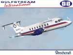
I am very proud to present this repaint of the PMDG Beechcraft B1900D in the livery of Gulfstream International Airlines. Gulfstream International Airlines flies their fleet of B1900D's in their own livery as well as the Continental Connection livery. Gulfstream International operates as a Continental Connection carrier and flies connecting routes to/from KMIA, KFLL, KTPA, and KMCO. This repaint depicts the Gulfstream International Airlines livery of the B1900D. This livery of their B1900D shows up regularly at MYNN and other islands of the Bahama island chain. This is a very detailed and realistic repaint. The logos are all hand-painted. All repainted textures in this package are 32-bit with no mipmaps. This is a textures only package. You must own the PMDG Express B1900D to enjoy this repaint.
| Filename: | Gulfstream_International_Airlines_Beechcraft_B1900.zip |
| License: | Freeware, limited distribution |
| Added: | 17th July 2010, 02:42:18 |
| Downloads: | 467 |
| Author: | Jeffrey S. Bryner, PMDG |
| Size: | 8.37 MB |
| Category: Flight Simulator X - AI Aircraft | |
| Fsx Air Flamenco Trislander Textures |
|
Images related to this file:
File Description:
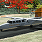
Fsx Air Flamenco Britten-Norman Bn-2A Mk III Trislander Textures.
Air Flamenco is a small fleet based in San Juan, Puerto Rico, which connects the main island with the smaller ones of Vieques and Culebra. They may occasionally fly to the US and British Virgin Islands. There are nine BN-2, three Shorts and a Trislander active to this date.
This texture for Air Flamenco Trislander N920GD completes my previous Air Flamenco fleet available on Flightsim.com and Avsim (air_flamenco_fleet_2021.zip). Requires Michael Pearson's base model mpai_bn2am3_trislander_traffic.zip, available on Avsim.
The model should be compatible with FSX up to P3Dv3. Please refer to modeler's documentation.
I've also added flight plans based on Flightradar24's and other websites. They are not 100% accurate but should provide an idea of the recent traffic.
| Filename: | Fsx_Air_Flamenco_Trislander_Textures.zip |
| License: | Freeware |
| Added: | 17th December 2021, 00:23:30 |
| Downloads: | 131 |
| Author: | Freddy Guerra |
| Size: | 1.07 MB |
| Category: Flight Simulator 2004 - Flight Plans | |
| Sounds Air, New Zealand - 2 Flights - Sep 2006 |
|
File Description:
Two little flights - set in the modern era, which is a departure for me - that are replicas of the real-world services offered by New Zealand's "Sounds Air" company. As well as providing scenic flights and charters they also operate timetabled services between Wellington and locations across Cook Straight in the South Island, such as Picton, Nelson and Kaikoura, the latter two being featured here. Their web-site is at ->> http://www.soundsair.com/ <<- and is worth a visit as there is full information relating to the timetables and also some great photographs. The aircraft used in this re-enactment - KLC - is also featured. The FS2004 model - the GA-8 Airvan by Mike Stone - is available at his site:- www.pmstone.com.
The Sounds Air livery - by Dan Hayward - is available here at Avsim.com and is named ga8klc.zip.
| Filename: | Sounds_Air_New_Zealand__2_Flights__Sep_2006.zip |
| License: | Freeware |
| Added: | 23rd September 2006, 06:17:38 |
| Downloads: | 405 |
| Author: | Bruce Kennewell |
| Size: | 241.14 KB |
| Category: Flight Simulator 2004 - Scenery | |
| Brevoort CWOB and BAF-3 radar plus Cartwright LAB-6 radar Canada |
|
Images related to this file:
File Description:
Brevoort airstrip and the BAF-3 radar it serves is on Brevoort Island, off one of the southeastern tips of Baffin Island and 140 miles east of Iqaluit. This scenery includes the BAF-3 buildings on the hilltop and those on the airstrip below, plus the roads connecting them and down to the beach landing area on the rocky coast. This scenery is made for the FSGenesis 76m terrain mesh for northern Canada, and there will be a repost of all my northern Canada airfields to suit this; I cannot think now why I never installed this mesh before. The AI reflects the use of civil airlines for resupply and transportation of personnel. Given the terrain the wind should be from the north so that ai lands using the 02 runway. Landing from the north will involve a terrain clash while take off towards the north will not as the climb out clears the hilltop. The video shows the 600 foot cliff at the runway threshold and an Air Tindi plane on the apron. Cartwright CYCA is on the Labrador coast and has been posted by Flight Ontario as part of their Goose Bay and Labrador Regional Airports sceneries. The nearby LAB-6 radar site is included here, connected to CYCA by an extended road. The site uses the same buildings as Brevoort and Saglek (posted recently) and although I have included them here as separate sceneries the contents can be placed in the same folders as Saglek with a saving in duplicated textures. The textures here are more accurate than Saglek so say yes to over-write; a downloader with personal experience of Brevoort noted that in reality they are lighter.
| Filename: | Brevoort_CWOB_and_BAF3_radar_plus_Cartwright_LAB6_.zip |
| License: | Freeware, limited distribution |
| Added: | 20th August 2017, 15:46:36 |
| Downloads: | 176 |
| Author: | Roger Wensley |
| Size: | 4.37 MB |
| Category: Flight Simulator 2004 - Scenery | |
| Frozen Canadian & USA Rivers & Lakes Revision |
|
Images related to this file:
File Description:
This "freezes" all lakes and rivers for winter flying and means they can be landed on with skis or wheels; it is meant for low level flying rather than high level jet flights. This edition is complete in itself and now really covers all of Canada and parts of the USA along the border, including large parts of Michigan, Wisconsin, Minnesota, North Dakota, and Montana. It is reversible with an "untick" in the FS scenery library. The revision is the addition of frozen sea in the area of Baffin Island (where I and Sid & Pete have recently posted all of the Baffin Island airfields) as I missed this area last time. Sorry about that. I have spent some time making sure that the sea and the inlets along the coast in the south do not get frozen too, and also some of the lakes that are close to the coast and rarely get cold enough to freeze over. The Great Lakes do not usually totally freeze, but this is an either ON or OFF modification and partial freezing cannot be convincingly simulated, so I went for total ice. Along the north shore I went for the peak of the winter with sea ice all the way to the permanent polar cap; this is not totally realistic as there is usually a partially open lead along the coast, but as with the Great Lakes...... It will work without Ultimate Terrain, but as UT is what gets all the lakes and rivers there and in the right place (except in the far north) it is obviously much improved with UT. The pics show Rockcliffe in the winter with the frozen Ottawa River for real and in FS for comparison; without UT the river would not be in the right place.
| Filename: | Frozen_Canadian__USA_Rivers__Lakes_Revision.zip |
| License: | Freeware, limited distribution |
| Added: | 6th September 2011, 00:42:43 |
| Downloads: | 623 |
| Author: | Roger Wensley |
| Size: | 1.2 MB |
| Category: Flight Simulator 2004 - Scenery | |
| Knight Inlet CF36 float base in British Columbia, Canada |
|
Images related to this file:
File Description:
Knight Inlet is a floating lodge that organises "nature experiences", ranging from close encounters with local grizzly bears to fishing. Knight Inlet is to the north of "the narrows" where the Inside Passage gets squeezed between the mainland and Vancouver Island, and there is a chart section attached with a pointer to the location. At the bottom of the chart is Campbell River floatbase, and to the west is Port Hardy. Knight Inlet initially runs east-west, and the lodge is tucked into a smaller north-south offshoot, close to where the main inlet turns north. The water runway here is in the middle of the north-south offshoot, though of course in reality the "runway" is wherever the wind dictates it to be. The names highlighted in green on the chart are float bases to be renovated and posted with working AI. The buoyed log boom next to the lodge is to keep escaped logs from drifting in and colliding with boats; float plane pilots keep their eyes peeled too. Because of large hills adjacent to the lodge the landing of the AI may or may not take place, depending on wind direction and whether or not they fly into rock before landing. Take off and departure are far more reliable, particularly if the wind is from the south. Most of the AI is from Vancouver Harbour, Harbour Air Otters and West Coast Air Beavers, plus a SeAir Beaver from Campbell River and a private Cessna from the nearby Minstrel Island. This is the second in a series of new and renovated float bases in BC (the first being Sproat Lake) and to cope with the AI demands FSAddon have authorised the inclusion here of a bunch of AI Otters and Beavers that were originally part of a payware scenery for the area. Thanks are due there.
| Filename: | Knight_Inlet_CF36_float_base_in_British_Columbia_C.zip |
| License: | Freeware, limited distribution |
| Added: | 23rd December 2016, 08:16:24 |
| Downloads: | 220 |
| Author: | Roger Wensley |
| Size: | 16.95 MB |
| Category: Flight Simulator 2004 - Scenery | |
| Dutch Harbour PADU in Alaska PLUS AI Air & Sea |
|
Images related to this file:
File Description:
This is a revised and much-added-to update of my earlier Dutch Harbor post, adding more Air & Sea AI. It is complete in itself and does not require you to have previously installed the original. New parking is for a civilian freighter, a Coast Guard C-130, and Coast Guard helicopters that fly from St Paul Island.
There is also a daily flight from Dutch Harbor to Akutan that will be by the amphibious Goose as there is no land runway at Akutan [more posts follow].
The official airport name is Unalaska, but a seat booked with airlines will be to Dutch Harbor, known from the tv series as a fishing centre with major fish and crab processing plants. In town the largest company is Unisea, taking up all of what was once Expedition Island and the adjacent shoreline. The out-of-town expansion is taking place along the shore of Captains Bay to the southwest, and here the largest is Westward with the uniform green roof for the plant and the residential buildings for seasonal workers.
The airport has just over 3,900 feet of 100 feet wide asphalt, aligned 30/12, lit, and between sea and hill with two aprons at the southeast end. There is no control tower at the airport, so don't be surprised when you are required to contact Cold Bay USAF for landing permission. Runway 30 has at its threshold a road; when a plane is landing or taking off traffic is stopped by barriers and lights. To encourage full use of the runway the fence is made up of plastic rods that bend on impact instead of chainlink topped with barbed wire that will turn a light plane upside down.
| Filename: | Dutch_Harbour_PADU_in_Alaska_PLUS_AI_Air__Sea.zip |
| License: | Freeware, limited distribution |
| Added: | 7th August 2012, 20:56:03 |
| Downloads: | 1,535 |
| Author: | Roger Wensley |
| Size: | 13.4 MB |
| Category: Flight Simulator X - Aircraft Repaints, Textures and Modifications | |
| Consolidated PBY-5A (G-PBYA) |
|
Images related to this file:
File Description:
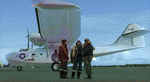
A repaint for the Aerosoft PBY-5 Catalina in the colors of G-PBYA, originally ordered for the Royal Canadian Air Force as a Canso A amphibian, basically equivalent to the US Navy PBY-5A. It was built by Canadian Vickers at Cartierville, Quebec and was allocated their constructors number CV-283 before adopting the RCAF serial 11005. It was taken on charge by the air force on 27 October 1943 and initially saw service with 9 (Bomber Reconnaissance) Squadron at Bella Bella on the British Columbia coast between Vancouver and Prince Rupert. It was on their inventory from November to the following August. 9 Squadron had been based at Bella Bella for some time prior to the arrival of Cansos, having operated Supermarine Stranraers there. The Cansos were mainly operated from water despite their amphibious undercarriages and were used on day and night patrols, looking out for enemy submarines. By mid-1944, the threat of a Japanese invasion of Western Canada had receded and it was decided to disband 9 Squadron and close the station at Bella Bella. The Cansos, including 11005, were flown to Alliford Bay in the Queen Charlotte Islands, also in British Columbia, and transferred to 7 (BR) Squadron in August. The job was the same – anti-submarine patrols mostly – and 11005 remained with 7 Sqn until it too was disbanded on 25 July 1945. After a post-war career as transport and waterbomber, it was acquired by Plane Sailing in 2004, restored and repainted as a OA-10A of the USAAF. It is based in Duxford. More info here: http://www.catalina.org.uk/. Repaint by Jan Kees Blom, based on the paintkit by Aerosoft.
| Filename: | Consolidated_PBY5A_GPBYA.zip |
| License: | Freeware |
| Added: | 13th July 2018, 20:37:22 |
| Downloads: | 182 |
| Author: | Jan Kees Blom |
| Size: | 10.18 MB |
| Category: Prepar3D V1-4 - Scenery | |
| Progetto Maldive |
|
File Description:
The Atolls of the Maldives are numerous and some atolls are also uninhabited. The most famous atolls are: The Male Atoll and Baros island N4.18.26 E73.20.91 with the VRMM airport, the Gan atoll N0.41.36 E73.9.27 with the VRMG airport, Hanimardhoo Atoll N6.44.56 E73.10.06 with the VRMH airport, the Kaadedhahoo atoll N0.29.21 E72.59.41 with the VRMT airport and the Kadhdhoo N1.51.30 E73.31.15 with the VRMK airport. The aforementioned airports have been improved and the most important resorts have been created on the islands of Baros, Gan, Hanimaadhoo, Kaadedhahoo and Kadhdhoo, and small ports have been created with ships and boats with Google Maps report. I remember that all the islands can be easily visited by seaplanes in their respective tiny ports. Good VFR flight.
Within the downloaded package you will find readme files for scenery installation. Good fly VFR. Pasquale Marrulli.
| Filename: | Progetto_Maldive.zip |
| License: | Freeware |
| Added: | 29th January 2018, 18:38:35 |
| Downloads: | 328 |
| Author: | Pasquale Marrulli |
| Size: | 8.56 KB |
| Category: Flight Simulator 2004 - Scenery | |
| Georgian Bay Airfields CYEM & CNR4 in Ontario, Canada |
|
Images related to this file:
File Description:
These are two airfields in Ontario around Georgian Bay, which is off the east side of Lake Huron in the Great Lakes. Manitoulin East Muni CYEM is at the northern end of the Bay in an area of coves and lakes, on what is actually an island that is almost but not quite connected to the mainland in several places. There is no immediately adjacent town and the field serves the county area. The runway is 3,500 feet of asphalt aligned 02-20 with PAPI at both ends. The second airfield is Tobermory CNR4, which is just south of the small town and ferry terminal of the same name on the northern end of the peninsula that forms Georgian Bay. The runway is 3,180 feet long and aligned 12-30; there is no longer a 450 feet displacement to the 30 threshold.
| Filename: | Georgian_Bay_Airfields_CYEM__CNR4_in_Ontario_Canad.zip |
| License: | Freeware, limited distribution |
| Added: | 12th August 2018, 19:31:18 |
| Downloads: | 139 |
| Author: | Roger Wensley |
| Size: | 17.45 MB |


© 2001-2026 AVSIM Online
All Rights Reserved
Privacy Policy |