
Where Flight Simulation Enthusiasts Gather from Around the World!
AVSIM Library - Search Results

| Category: Flight Simulator 2004 - Scenery | |
| Sachs Harbour CYSY in Northwest Territories, Canada |

|
Images related to this file:
File Description:
Sachs Harbour is on the southwest coast of Banks Island on the north side of Amundsen Gulf, around 240 miles northeast of Tuktoyaktuk and 180 miles northwest of Ulukhaktok. The village is the only permanent settlement on the island, and is located where it is to benefit from the harbour shelter provided by offshore land. The population is only 130 or so folks, who live on hunting and fishing with some tourism. One claim to fame is that the island is home to threequarters of the world's population of muskoxen and the second is the largest goose colony in North America. The airfield is on the plateau just above the village at 282 feet ASL. The gravel runway 084T/264T (true bearings in Northern Domestic Airspace) is 4,000' long and 100' wide and lit. The apron is on the south side at the centre of the runway and there is a new terminal building; there is JetA fuel available and perhaps 100LL in drums. To the west of the airfield are the deserted buildings of what was once a Department Of Transport weather station. Aklak Airlines flights (operated by Kenn Borek) fly to Sachs Harbour from Inuvik three times a week in summer and twice a week at other times; the AI will be included in the post of a revised Aklavik, and Inuvik revised and Tuktoyaktuk should be fully installed BEFORE Sachs Harbour.
| Filename: | Sachs_Harbour_CYSY_in_Northwest_Territories_Canada.zip |
| License: | Freeware, limited distribution |
| Added: | 14th May 2012, 17:20:09 |
| Downloads: | 395 |
| Author: | Roger Wensley |
| Size: | 6.16 MB |
| Category: Flight Simulator 2004 - Scenery | |
| Campbell River floats CAE3 in BC Canada |
|
Images related to this file:
File Description:
Campbell River is a medium sized town on Vancouver Island, some 50 miles north of Vancouver. The base is just north and west of the town on Spit Road. And Ultimate Terrain is required for the cost to be in the right place. The docks are on the south side of the spit, on the (relatively) sheltered river side, though take offs and landings are requested to take place outside the harbour if conditions permit. The base is noted as used and run by Corilair, though in fact there is also another company based there, Vancouver Island Air, who like Coril Air also have two docks, one for boarding passengers and one for maintenance and refuelling tie-ups. At the river mouth there is a small marina, run by the same folks who run the trailer park, and next to that a dock for visiting float planes. There is a seventh dock at the end furthest from the river mouth; I don't know what that is used for but it is next to Vancouver Island Air and might be theirs. At low tide there are numerous sandbanks (and more permanent islands with bushes and trees) in the mouth of the Campbell River and I decided to ignore installing these with all the problems they would cause me. The main buildings and most of the others are modeled specifically for this scenery; minor items like parked cars are RWY12.
| Filename: | Campbell_River_floats_CAE3_in_BC_Canada.zip |
| License: | Freeware, limited distribution |
| Added: | 12th February 2010, 18:45:00 |
| Downloads: | 881 |
| Author: | Roger Wensley |
| Size: | 5.3 MB |
| Category: Microsoft Flight Simulator (2020) - Aircraft Repaints, Textures and Modifications | |
| Britten-Norman BN-2A Islander C-GILS Sable Aviation |
|
Images related to this file:
File Description:
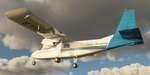
This folder contains a repaint for the Britten-Norman BN-2 Islander by Blackbox Simulations It shows Britten Norman BN-2 Islander #416 C-GILS of Sable Aviation, based in Halifax, Nova Scotia, Canada. They use the aircraft for flights to Sable Island, a national park reserve 300 km SE of Halifax, where they land on the beach. Repaint by Jan Kees Blom Repaint by Jan Kees Blom.
| Filename: | BrittenNorman_BN2A_Islander_CGILS_Sable_Aviation.zip |
| License: | Freeware |
| Added: | 21st May 2021, 18:10:04 |
| Downloads: | 27 |
| Author: | Jan Kees Blom |
| Size: | 25.23 MB |
| Category: Prepar3D V1-4 - Scenery | |
| ITALY ETM20m - Enhanced Terrain Mesh vol. 00 ver 1.10 |
|
Images related to this file:
File Description:
File Description:
Italy - ETM Enhanced Terrain Mesh 0.73 arc sec (20 meters). This Terrain Mesh is fully compatible with FSX/P3D (all versions). This is a work in progress. Volume 00 - Sicily, Aeolian Islands, Egadi Islands, Ustica Island and Pelagie Islands.
----------------------
MIND OUT THERE! THIS VERSION REPLACE THE PREVIOUS (vers. 1.00). BECAUSE THERE WAS AN ERROR IN THE MESH MAP; THE MALTESE ARCHIPELAGO WAS FLATTENED. THIS VERSION FIXES IT.
| Filename: | ITALY_ETM20m__Enhanced_Terrain_Mesh_vol_00_ver_110.zip |
| License: | Freeware |
| Added: | 11th January 2019, 22:39:17 |
| Downloads: | 460 |
| Author: | Giovanni Miduri |
| Size: | 52.04 MB |
| Category: Prepar3D V1-4 - Aircraft Repaints, Textures and Modifications | |
| A2A Piper Cherokee Aeroclub Bastia |
|
Images related to this file:
File Description:
It looks like that the Aeroclub of Bastia has only one aircraft and it is F-HTEC. This livery is for A2A's Piper Cherokee although the original aircraft is a Piper Warrior III. I'm not to blame for any imperfections you spot! And don't blame me either if you fall in love with the beautiful island of Corsica while flying around! These files are texture only. Have fun.
| Filename: | A2A_Piper_Cherokee_Aeroclub_Bastia.zip |
| License: | Freeware |
| Added: | 15th November 2019, 19:14:05 |
| Downloads: | 89 |
| Author: | Yves Kaulitz |
| Size: | 14.78 MB |
| Category: Flight Simulator 2004 - Scenery | |
| Tiksi bay, Russia (as it appears before 1940). |
|
Images related to this file:
File Description:
MSFS2004 scenery: Tiksi bay (as it appears before 1940) - settlement in Bulunsky Ulus of the Sakha Republic, Russia - situated on the Arctic Ocean coast. Freeware (c) 2009 Alexander Belov.
This scenery represents the Tiksi bay in the late of 1930-th years. It includes Tiksi airstrip and seaplane mooring positions, Tiksi polar station and Muostakh Island polar staton. Also Tiksi seaport, Tiksi and Sogo villages are presented.
| Filename: | Tiksi_bay_Russia_as_it_appears_before_1940.zip |
| License: | Freeware, limited distribution |
| Added: | 31st May 2010, 12:57:13 |
| Downloads: | 189 |
| Author: | Alexander Belov |
| Size: | 3.12 MB |
| Category: Navigation and ATC - Navigation | |
| Papua New Guinea charts 1 of 3 |
|
Images related to this file:
File Description:

Calibrated for FSMap, but scanned images can be used in other map software, such as FSM Moving Map (FSMMM) by Rana Hossain. Chart source: Topographic Maps U.S. Army Map Service, Series T504, original scale 1:250,000, date 1964-. Courtesy of the University of Texas Libraries, The University of Texas at Austin. Missing: I could not find equivalent charts for New Britain; for this island, a lower-quality chart is included.
| Filename: | Papua_New_Guinea_charts_1_of_3.zip |
| License: | Freeware |
| Added: | 5th June 2010, 03:40:04 |
| Downloads: | 1,213 |
| Author: | David Wilson-Okamura |
| Size: | 34.25 MB |
| Category: Flight Simulator 2004 - AI Flight Plans | |
| Airlines of Tasmania and Par Avion - amended |
|
Images related to this file:
File Description:

The following flightplans are to accompany my recent repaints of the Tasmanian services, Airline of Tasmania and ParAvion. They are in raw text format, and should be compiled for FS2004 using Traffic Tools. AFCADs are enclosed for fields lacking them from other sources.
THESE ARE CORRECTED PLANS AS OF 15 Nov 2011 due to an overlooked miscode of Cape Barren Island as YCBN, when it should have been YCBI.
| Filename: | Airlines_of_Tasmania_and_Par_Avion__amended.zip |
| License: | Freeware, limited distribution |
| Added: | 15th November 2011, 19:16:56 |
| Downloads: | 460 |
| Author: | John Burford |
| Size: | 90.69 KB |
| Category: Flight Simulator X - AFCAD Files | |
| Southampton Heliport (87N), NY |
|
File Description:
This is a public helipad, the only public helipad on Long Island outside of an airport, that services the town of Southampton, New York. Air taxi operations are common out of this heliport. It shares a CTAF with Mattituck Airport (21N) to the north, but since FSX does not have helicopter AI traffic (unless you have an AI package installed for it) you really don't need it anyways.
| Filename: | Southampton_Heliport_87N_NY.zip |
| License: | Freeware |
| Added: | 1st October 2010, 20:10:14 |
| Downloads: | 236 |
| Author: | Drew Sikora |
| Size: | 115.11 KB |
| Category: Navigation and ATC - Navigation | |
| Papua New Guinea Charts 2 of 3 |
|
Images related to this file:
File Description:
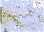
Calibrated for FSMap, but scanned images can be used in other map software, such as FSM Moving Map (FSMMM) by Rana Hossain. Chart source: Topographic Maps U.S. Army Map Service, Series T504, original scale 1:250,000, date 1964-. Courtesy of the University of Texas Libraries, The University of Texas at Austin. Missing: I could not find equivalent charts for New Britain; for this island, a lower-quality chart is included.
| Filename: | Papua_New_Guinea_Charts_2_of_3.zip |
| License: | Freeware |
| Added: | 7th May 2010, 10:45:02 |
| Downloads: | 797 |
| Author: | David Wilson-Okamura |
| Size: | 34.63 MB |


© 2001-2026 AVSIM Online
All Rights Reserved
Privacy Policy |