
Where Flight Simulation Enthusiasts Gather from Around the World!
AVSIM Library - Search Results

| Category: Flight Simulator X - Aircraft Repaints, Textures and Modifications | |
| Maya Island Air, Cessna C208B Grand Caravan (V3-HGP) |

|
Images related to this file:
File Description:
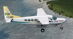
This folder contains a repaint for the Carenado Cessna C208B Grand Caravan, in the colors of V3-HGP, one of the C208B's flown by Maya Island Air, an airline based in Belize. Repaint by Jan Kees Blom, based on the blank textures by Carenado.
| Filename: | Maya_Island_Air_Cessna_C208B_Grand_Caravan_V3HGP.zip |
| License: | Freeware |
| Added: | 9th October 2011, 20:50:12 |
| Downloads: | 401 |
| Author: | Jan Kees Blom |
| Size: | 8.58 MB |
| Category: Flight Simulator X - Scenery | |
| YLEA Leeman, Western Australia (Snag Island) airstrip and town |
|
File Description:
YLEA Leeman - formerley Snag Island is a tiny fishing village which is ideal for fishermen and holiday makers eager to get away from the more commercialised centres. Calling itself the 'Home of Western Australia's Dhufish' the settlement boasts huge and dramatic white sand dunes, good beach and offshore fishing, safe beaches for surfing, swimming and sailboarding, and superb displays of wildflowers in the spring. Leeman is home to a crayfish (lobster) fishing fleet which plies the fishing grounds off the coast in the season. The industry developed in the 1950s and has since become one of the most important on the Central West coast. It is also a dormitory suburb for the nearby sand mining town of Eneabba. REQUIRES Blencowe_LibraryKit.zip
REQUIRES blencowe_librarykit_309494.zip (Available HERE)
| Filename: | YLEA_Leeman_Western_Australia_Snag_Island_airstrip.zip |
| License: | Freeware |
| Added: | 28th February 2013, 13:54:58 |
| Downloads: | 229 |
| Author: | Alan Blencowe |
| Size: | 1.39 MB |
| Category: Flight Simulator 2004 - Scenery | |
| Ontario Small Fields in Canada: #05 Pelee Island (CYPT) |
|
Images related to this file:
File Description:
This is the fifth in a series of small airfields in southern Ontario Canada, Pelee Island CYPT, an airfield on the island in Lake Erie and the southernmost airfield in Canada. The airfield has an asphalt runway of 3,300 feet, aligned 09/27 in FS9 while today in real life it is 10/28 due to the wandering magnetic pole. There is also a second runway, 36/18 and around 1,500 feet of gravel. There is a small terminal building which now has blue cladding; here it is still in the dirty yellow of the original colour scheme.
This version is based upon what appears to be a "lost" 2005 scenery of Pelee Island. When I started to make Pelee Island I discovered that in fact I already had a version installed; my memory can be excused, as I installed it in 2005. I modified the scenery to include parking, taxiways that connected, revised runway markings, new windsocks, new signage, larger apron, parked cars and planes, revised landclass, AI, etc. My intention was to instruct you to download and install the original and then incorporate my changes. Problem: it does not appear to exist for download; perhaps it was washed away when the Avsim site crashed. I have included it in this post. If anyone knows who made it please let me know.
| Filename: | Ontario_Small_Fields_in_Canada_05_Pelee_Island_CYP.zip |
| License: | Freeware, limited distribution |
| Added: | 5th August 2015, 18:52:25 |
| Downloads: | 171 |
| Author: | Roger Wensley |
| Size: | 4.39 MB |
| Category: Flight Simulator 2004 - Scenery | |
| FHSH - St. Helena Island & Airport - St. Helena, South Atlantic |
|
Images related to this file:
File Description:
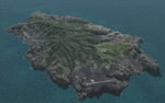
This project is a port of my FSX release of the the new airport (FHSH) on St. Helena Island. This scenery provides more accurate coastlines and roads, as well as corrected landclass based on the latest available satellite imagery. Flight plans are provided for the proposed commercial service to St. Helena, and some additional GA and military flights to the island are added as well.
The FS2004 St. Helena (FHSH) airport was created by aligning master plans for the airport with current satellite data and by studying many of the pictures that have been posted as the airport has taken shape. The official opening of the real airport on May 21, 2016, has been pushed back for more field tests due to challenging crosswinds. Updates were created or rebuilt in a manner which carefully aligns airport data with current satellite imagery. Scenery was created using Airport Design Editor 9 v1.67.5684 and SBuilder. Scenery objects were added and modified from stock FS9 scenery to resemble as closely as possible the actual airports.
| Filename: | FHSH__St_Helena_Island__Airport__St_Helena_South_A.zip |
| License: | Freeware |
| Added: | 5th May 2016, 07:44:38 |
| Downloads: | 2,237 |
| Author: | Carlyle Sharpe |
| Size: | 1.62 MB |
| Category: Flight Simulator X - Scenery | |
| The Bounty Island "Pitcairn" coordinates S 25.03'14 "W 130.06'16" |
|
File Description:
Pitcairn is an island of the Pacific Ocean, the second largest in the British territory of the Pitcairn Islands and the only inhabited area; On it is the capital, Adamstown. The surface area is 4.6 km². On this flap of land, located 2200 km east of Tahiti, settled in Bounty's ammunition in 1790. Geographic coordinates S 25 ° 03'14 "W 130 ° 06'16". My scenario shows exactly where the Bounty ship threw anchor. In the attached package you will find readme to install the scenery
| Filename: | The_Bounty_Island_Pitcairn_coordinates_S_250314_W_.zip |
| License: | Freeware |
| Added: | 31st August 2017, 18:51:53 |
| Downloads: | 246 |
| Author: | Pasquale Marrulli |
| Size: | 1.85 KB |
| Category: Flight Simulator X - Scenery | |
| KPVD, T. F. Green State Airport, Providence, Rhode Island |
|
Images related to this file:
File Description:
Complete new setup with ADE, from satellite images. T.F. Green Airport is 6 miles south of Providence. It is a public international airport, categorized by the FAA as a small hub primary commercial service facility.
| Filename: | KPVD_T_F_Green_State_Airport_Providence_Rhode_Isla.zip |
| License: | Freeware |
| Added: | 21st November 2017, 22:44:01 |
| Downloads: | 543 |
| Author: | Tim van Ringen |
| Size: | 829.15 KB |
| Category: Flight Simulator X - Scenery | |
| KPVD, Theodore Francis Green State Airport, Providence, Rhode Island |
|
Images related to this file:
File Description:
Complete new setup, done with ADE, from top-down images. T.F. Green Airport is 6 miles south of Providence. It is a public international airport, categorized by the FAA as a small hub primary commercial service facility.
| Filename: | KPVD_Theodore_Francis_Green_State_Airport_Providen.zip |
| License: | Freeware |
| Added: | 24th November 2017, 17:25:20 |
| Downloads: | 1,282 |
| Author: | Tim van Ringen |
| Size: | 727.13 KB |
| Category: Flight Simulator 2004 - Scenery | |
| Mary River CMR2 on Baffin Island in Nunavut Canada |
|
Images related to this file:
File Description:
This is a very early version of an airfield in Nunavut built to serve an iron ore mine some 100 miles south of Pond Inlet on Baffin Island. In 2004 the airstrip was just being built, with a very basic camp set up for the construction crew who then went on to develop the roads etc in the immediate area. The original plan was for an opencast mine, with ore being transported south on a new (and expensive) railroad link to a new port on the south shore of Baffin Island. This plan was later changed to a (much cheaper) road to Milne Inlet, north of Mary River. And there my story rests, as although production has now started I have no further information about the operating mine. Nolinor currently flies regular supply flights into the camp; the AI here is for the early days. The gravel runway is 4,800 feet long and 150 feet wide, aligned 124T-304T as all runway headings in the north are given as true rather than the unreliable magnetic, which would be 12-30. Runway lighting and PAPI was installed early on and is included here; signage is not and the apron is the early version.
| Filename: | Mary_River_CMR2_on_Baffin_Island_in_Nunavut_Canada.zip |
| License: | Freeware, limited distribution |
| Added: | 18th August 2018, 02:57:19 |
| Downloads: | 136 |
| Author: | Roger Wensley |
| Size: | 4.82 MB |
| Category: Prepar3D V1-4 - Aircraft Repaints, Textures and Modifications | |
| Condor Airbus A330-200 (D-AIYA) "Condor Island" tail |
|
Images related to this file:
File Description:
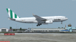
Condor D-AIYA new livery textures for the excellent Thomas Ruth Airbus A330-200. Textures only, for FSX and P3D! By Max Schloegl.
| Filename: | Condor_Airbus_A330200_DAIYA_Condor_Island_tail.zip |
| License: | Freeware |
| Added: | 7th June 2023, 00:48:37 |
| Downloads: | 99 |
| Author: | Max Schloegl |
| Size: | 19.41 MB |
| Category: Prepar3D V1-4 - Aircraft Repaints, Textures and Modifications | |
| Condor Airbus A330-200 (D-AIYD) "Condor Island" tail |
|
Images related to this file:
File Description:
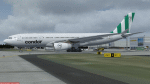
Condor D-AIYD new livery textures for the excellent Thomas Ruth Airbus A330-200. Textures only, for FSX and P3D! By Max Schloegl.
| Filename: | Condor_Airbus_A330200_DAIYD_Condor_Island_tail.zip |
| License: | Freeware |
| Added: | 7th June 2023, 00:49:18 |
| Downloads: | 124 |
| Author: | Max Schloegl |
| Size: | 19.42 MB |


© 2001-2026 AVSIM Online
All Rights Reserved
Privacy Policy |