
Where Flight Simulation Enthusiasts Gather from Around the World!
AVSIM Library - Search Results

| Category: Flight Simulator 2002 - AI Flight Plans | |
| Cie Corse Mediterranee |

|
File Description:
CCM French airliner operating between Corse Island and the major French airports sharing some flights with Air France. Temporary complete pack' for ATR 42-500 and CRJ 200 (It'll be updated soon with the good planes, ATR 72 and F100).
| Filename: | Cie_Corse__Mediterranee.zip |
| License: | Check within download |
| Added: | 26th October 2002, 01:50:17 |
| Downloads: | 873 |
| Author: | midouman |
| Size: | 660.89 KB |
| Category: Flight Simulator 2002 - Scenery | |
| Rothera Research Station |
|
File Description:
Rothera Base is a research station of the 'British Antarctic Survey' and
was established in 1975. It is located on Adelaide Island (Antarctic
Peninsula) about 800 nm south of Tierra del Fuego (Argentina). It has
a 900 m gravelstrip and NDB.
| Filename: | Rothera_Research_Station.zip |
| License: | Freeware |
| Added: | 24th June 2003, 22:17:07 |
| Downloads: | 1,055 |
| Author: | Uli Klapp |
| Size: | 2.52 MB |
| Category: Flight Simulator 2002 - Scenery | |
| Busuanga Airstrip Scenery, Busuanga, Coron, Philippines |
|
File Description:
Version 1.0
July 16,2003
Busuanga Airport is one of the destination airports of SOUTHEAST ASIAN AIRLINES.Busuanga scenery is located in the island of Coron, Palawan, Philippines.This airport is a must to complete the LET-410 ADVENTURE for the Philippine sceneries!
| Filename: | Busuanga_Airstrip_Scenery_Busuanga_Coron_Philippin.zip |
| License: | Freeware |
| Added: | 16th July 2003, 16:08:03 |
| Downloads: | 543 |
| Author: | Ver Walter L. Gulfan |
| Size: | 441.09 KB |
| Category: Flight Simulator X - Aircraft Repaints, Textures and Modifications | |
| Chance Vought F4-U Corsair VMF-511 #82 "Daisy June" |
|
Images related to this file:
File Description:
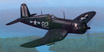
This folder contains a repaint for the Aircraft Factory F4U Corsair, representing #82 "Daisy June", an aircraft of VMF-511, based on USS 'Block Island' in july 1945. Repaint by Jan Kees Blom, based on the paintkit by Aircraft Factory.
| Filename: | Chance_Vought_F4U_Corsair_VMF511_82_Daisy_June.zip |
| License: | Freeware |
| Added: | 5th August 2018, 16:55:10 |
| Downloads: | 123 |
| Author: | Jan Kees Blom |
| Size: | 10.76 MB |
| Category: Flight Simulator X - Scenery | |
| Isle of Wight (UK) reconstructed |
|
File Description:
This started out as a relatively simple project to correct the most obvious faults with the shape of the Isle of Wight, but instead of taking about a week it kept me going for a month.
As well as correcting the North and East coasts where the Island was almost unrecognisable I started putting in a few more roads.I then realised just how over populated the Island looked.There is built up areas all over the place , it looked terrible , so I have attempted to correct this . After this I thought I would put in a few of the larger factories and marinas etc.....
| Filename: | Isle_of_Wight__UK_reconstructed.zip |
| License: | Freeware, limited distribution |
| Added: | 24th February 2007, 22:43:28 |
| Downloads: | 4,257 |
| Author: | Len Hickman |
| Size: | 142.25 KB |
| Category: Flight Simulator X - Scenery | |
| Whale Island Scenery: "Islands of the Bay of Plenty" |
|
File Description:
This scenery was created from a digital Orthorectified aerial mosaic owned by Environment Bay of Plenty (The Bay of Plenty Regional Council). The imagery has been de-sampled for use in Flight Simulator X and utilizes the default terrain mesh. The textures are intended for summer daylight flying only, although due to the sparse nature of White Islands' Evegetation, the Islands appearance remains relatively consistent throughout the year.
It includes autogen trees, a landable helicopter pad on the top of the Island, Radio masts, and the Department of Conservation (DOC) hut in the south western bay of the island.
| Filename: | Whale_Island_Scenery__Islands_of_the_Bay_of_Plenty.zip |
| License: | Freeware, limited distribution |
| Added: | 9th May 2007, 08:42:59 |
| Downloads: | 1,496 |
| Author: | Tim Barnes |
| Size: | 7.05 MB |
| Category: Flight Simulator X - Scenery | |
| Electric Beach Version 1.0 |
|
File Description:
This scenery is an autogen scenery that sits on top of "MegaSceneryX - Hawaii - Honolulu and Oahu Island", SO IT REQUIRES THE MEGASCENERY X - Hawaii - Honolulu & Oahu Island"
This Autogen scenery starts at PHJR Airport with static military aircrafts, helos and birds and then westwards to BarbersPoint Harbor and then westwards to the resorts area and thence to Electric beach power plant.
I used autogens from default FSX as well as the FSX Acceleration. IF you did not install acceleration, it should not be an issue. you would just not see some of the autogens from the acceleration package.
| Filename: | Electric_Beach_Version_10.zip |
| License: | Freeware, limited distribution |
| Added: | 5th January 2008, 00:45:28 |
| Downloads: | 3,899 |
| Author: | Manny Mahadevan |
| Size: | 1.69 MB |
| Category: Flight Simulator 2004 - Scenery | |
| Turangi Airfield, New Zealand. NZTN. (to fit Turangi Photoreal area scenery, by Robin Corn) |
|
File Description:
Welcome to Turangi Airfield, 1nm North of the township of Turangi, at the southern end of the
beautiful Lake Taupo, in the central North Island of New Zealand.
The airfield is home to the Turangi Aero Club, and is served by Mountain Air, undertaking tourist flights
around the National Park and central North Island volcanoes, and flights to the Chateau and skifields
at Mount Ruapehu.
This scenery is built to fit into the freeware "Turangi" photoreal area scenery by Robin Corn, freely available
from avsim.com, filename...... godzoneturangi.zip . Requires some EZ Scenery Object sets (see INSTALL instructions for details).
| Filename: | Turangi_Airfield_New_Zealand_NZTN_to_fit_Turangi_P.zip |
| License: | Freeware, limited distribution |
| Added: | 7th November 2008, 22:48:37 |
| Downloads: | 665 |
| Author: | Lawrie Roache |
| Size: | 3.01 MB |
| Category: Flight Simulator 2004 - Scenery | |
| Fernando de Noronha, Brazil - SBFN (Photoreal for Fs9) |
|
File Description:
Photoreal Fs9 Fernando de Noronha island. This addon WAS NOT created by me,
but I was given permission to upload it. It's author is Amengol.
The island is steeped in history and has it's own connection with aviation history. For it was one of the fuel stops that were used on the very first Africa to South America trans-atlantic flight. March 30 - June 17, 1922, using three Fairey IIID floatplanes. Perhaps you might like to retrace the brave pilots route to see if you can make the trip!
Featuring: Photoreal textures, A.I. Aircraft, and Custom Terrain mesh.
| Filename: | Fernando_de_Noronha_Brazil__SBFN_Photoreal_for_Fs9.zip |
| License: | Freeware |
| Added: | 27th January 2009, 00:55:22 |
| Downloads: | 2,225 |
| Author: | Amengol and Rob Barnett |
| Size: | 2.84 MB |
| Category: Fly! II - TerraScene | |
| Hilton Head (Carolinas Project) TerraScene Project Pack |
|
Images related to this file:
File Description:
Re-upload. This TerraScene 2.1 Project pack covers all of global tile 198,152, extending the coastline from Charleston to the northern portion of Savannah, GA. Along the coast you will find such beautiful areas as Pritchards Island, Beaufort, and the famous Hilton Head Island. To the north is Walterboro, SC. The Savannah area includes Savannah International Airport. This pack includes updated Tiger Census (2000) shapefile data, adding new water areas, new highways, and other details. All scenery data files are included: USGS data, shapefiles, and a complete custom water mask. Requires TerraScene 2.1 and Fly!II patched to v230 or later.
| Filename: | Hilton_Head_Carolinas_Project_TerraScene_Project_P.zip |
| License: | Freeware |
| Added: | 27th May 2010, 03:02:58 |
| Downloads: | 185 |
| Author: | Randall Rocke |
| Size: | 55.06 MB |


© 2001-2026 AVSIM Online
All Rights Reserved
Privacy Policy |