
Where Flight Simulation Enthusiasts Gather from Around the World!
AVSIM Library - Search Results

| Category: Flight Simulator 2004 - Scenery | |
| Wrigley CYWY - Northwest Territories, Canada |

|
Images related to this file:
File Description:
Wrigley is the next in a series of airfields that follow (approximately) in a southward direction that early access route to the Canadian northern shore, the Mackenzie River. At the far northern end there is Tuktoyaktuk, then Inuvik, Fort McPherson, Fort Good Hope, and Deline, all posted. Wrigley is at 489 feet asl and on the east bank of the the Mackenzie, around 135 miles due south of Deline. The town of Wrigley has a population of only 125 or so folks, and was relocated to its current position in 1965 from Fort Wrigley to be near the WW2 era airfield; I have no idea where Fort Wrigley is, or was. The airport is just over a mile south of the town, and has 3,500 feet of gravel runway. North Wright Air have scheduled flights to here and other airfields up and down the Mackenzie (including Deline, Fort Simpson, and Fort Good Hope etc) which is reflected in the revised AI. There is again a mandatory radio frequency but I have set the "tower" as unmanned so you will announce intentions and join downwind. There is no fuel available.
| Filename: | Wrigley_CYWY__Northwest_Territories_Canada.zip |
| License: | Freeware, limited distribution |
| Added: | 5th July 2014, 21:01:37 |
| Downloads: | 211 |
| Author: | Roger Wensley |
| Size: | 3.81 MB |
| Category: Flight Simulator 2004 - Scenery | |
| Kugluktuk CYCO in Nunavut, Canada |
|
Images related to this file:
File Description:
Kugluktuk is on the coast of northern mainland Canada on the mouth of the Coppermine River. It is around 250 miles west of Cambridge Bay and 200 miles south of Ulukhaktok. Tuktoyaktuk is 450 miles west. Kugluktuk used to be called Coppermine as copper was mined along the banks of the river and used for spear and arrow heads, and this attracted a semi-permanent population. The population now numbers around 1,450. The airfield is inland from the village and the 5,500 feet of 100 feet wide gravel runway is aligned 121T/3301T where T stands for "true" as opposed to magnetic in the Northern Domestic Airspace. Both JETA-1 and 100LL are available, dispensed by a truck as the storage tanks are just off the northern edge of the field. There are flights by First Air and Canadian North and the AI includes a daily flight of each, plus a cargo visit by Buffalo; the closest large city is Yellowknife, 375 miles south. I should have mentioned a long time ago that to see the apron lights working requires you to have the "lights_ss_v2" by Sidney Schwartz installed.
| Filename: | Kugluktuk_CYCO_in_Nunavut_Canada.zip |
| License: | Freeware |
| Added: | 10th November 2012, 04:03:35 |
| Downloads: | 428 |
| Author: | Roger Wensley |
| Size: | 3.04 MB |
| Category: Flight Simulator 2004 - Scenery | |
| Frozen & Landable Lakes & Rivers for All Canada Winter Ski Operations |
|
Images related to this file:
File Description:
This "freezes" ALL Canadian lakes and rivers for winter flying and means they can be landed on with skis or wheels. This edition covers all of Canada plus parts of the USA along the border, including Michigan, Wisconsin, Minnesota, North Dakota, and Montana. It is reversible with an "untick" in the FS scenery library. I have spent some time making sure that the sea and the inlets along the coast do not get frozen too, and also some of the lakes that are close to the coast and rarely get cold enough to freeze over. Along the north shore I went for the peak of the winter with sea ice all the way to the permanent polar cap; this is not totally realistic as there is usually a partially open lead along the coast, but this would be difficult to replicate convincingly. This is really for use with Ultimate Terrain, though it will work without it. The pics show Rockcliffe in the winter with the frozen Ottawa River for real and in FS for comparison; without UT the river would not be in the right place.
| Filename: | Frozen__Landable_Lakes__Rivers_for_All_Canada_Wint.zip |
| License: | Freeware, limited distribution |
| Added: | 15th November 2010, 01:01:36 |
| Downloads: | 603 |
| Author: | Roger Wensley |
| Size: | 871.82 KB |
| Category: Flight Simulator 2004 - Scenery | |
| Sproat Lake CAA9 V2 on Vancouver Island in British Columbia, Canada |
|
Images related to this file:
File Description:
This presumes you have already installed Sproat Lake CAA9; it is not a stand-alone scenery. In the original post I omitted the traffic bgl. This is now included, as are the two AI Beavers that FSAddon gave permission for inclusion and use as AI with Sproat Lake. So if you already have installed the pay scenery they came with they will show up anyway, but if you don't then install these two and they will; just drop the Sproat Lake AI Beavers folder into your aircraft folder, and the traffic bgl into the FS9'Scenery/World/Scenery folder as usual. I have now also included a Grumman Goose amphibian as this was the plane that the Fire Boss would be operating in while fire fighting. The textures are what were available and that I could (limited skills here) revise to at least have a Canadian registration. If I find a more accurate version I will include it at a later date. Drop the bgl's and textures into the already installed Sproat Lake scenery and texture folders and say yes to overwrite or replace.
| Filename: | Sproat_Lake_CAA9_V2_on_Vancouver_Island_in_British.zip |
| License: | Freeware, limited distribution |
| Added: | 11th December 2016, 06:45:32 |
| Downloads: | 222 |
| Author: | Roger Wensley |
| Size: | 3.89 MB |
| Category: Flight Simulator 2004 - Scenery | |
| Mackar Inlet CWMI in Nunavut, Canada |
|
Images related to this file:
File Description:
Mackar Inlet was a DEW line Auxiliary Station on the west shore of the Melville Peninsula, which is part of the northern Canadian mainland. The station was closed only in 1992, so it is relatively intact. Hall Beach is 120 miles to the east, on the eastern shore of the peninsula, and Kugaaruk is just over 100 miles to the west. The runway is still in good condition and is around 3,800 feet of gravel 110' wide, aligned 164T/344T and at 100 feet ASL. The station buildings are up on the hill at 1,350 feet ASL and 5 miles to the south. None of these DEW line stations are particularly impressive or even interesting. However, you can bet that any pilot flying regularly in the north along the coast knows where all these runways are, in case one of them suddenly becomes his favourite in the whole world just after the sudden silence. I should have mentioned a long time ago that to see the apron lights working (on my fields that HAVE apron lights) requires you to have the "lights_ss_v2" by Sidney Schwartz installed.
| Filename: | Mackar_Inlet_CWMI_in_Nunavut_Canada.zip |
| License: | Freeware, limited distribution |
| Added: | 2nd December 2012, 17:58:34 |
| Downloads: | 216 |
| Author: | Roger Wensley |
| Size: | 1.16 MB |
| Category: Flight Simulator 2004 - Scenery | |
| Colville Lake CEB3 in Northwest Territories Canada |
|
Images related to this file:
File Description:
Colville Lake is a small village of around 150 Dene, located to the northwest of the Great Bear Lake and east of the Mackenzie River, 120 miles north of Norman Wells. The village and the airfield are next to each other and to the lake shore. I recently discovered which of the standard terminal buildings had been used there and this, along with information I already had, enabled me to now make the scenery, which is based on an approximate 2010 date. The gravel runway is lit and around 2,800 feet long, aligned 10-28. North Wright Air serves the village from it's headquarters at Norman Wells with daily flights by de Havilland Twin Otters, or "twotters" as they were quickly named among the northern Canadian airline personnel when they were first produced. The approximate time of this scenery is 2010. While testing this scenery I discovered that Tulita (previously called Fort Norman) which is another Mackenzie River airfield to the south of Norman Wells, needs to be reposted due to a terrain fault. If you find an error here then email me please, and note that my email address has been changed to rogwens at Gmail dot com.
| Filename: | Colville_Lake_CEB3_in_Northwest_Territories_Canada.zip |
| License: | Freeware, limited distribution |
| Added: | 31st July 2021, 18:23:48 |
| Downloads: | 68 |
| Author: | Roger Wensley |
| Size: | 4.51 MB |
| Category: Flight Simulator 2004 - Scenery | |
| Buckland PABL in Alaska |
|
Images related to this file:
File Description:
Buckland is a village on a small river, around 45 miles east of Deering and 15 miles inland from the river mouth. Like Deering, the population of 420 live from fishing and the land. The airfield is close by and has a gravel runway aligned 10-24 and 3,300 feet long with VASI at both ends. Apart from the airfield itself, and it's buildings, this scenery modifies the local (mostly treeless) land class, adds village buildings while reducing the village size to reality, and creates a new airfield background. Bering Air flies into Buckland from Kotzebue and is included in the AI. A note here about my scenery making. This is post number 505 and there will not be many more to follow this as I am almost at the end of the photos I either took or found for scenery purposes. There is a limit to what can be located online and I have already been making use of the little there is; eg Unalakleet. So, if you are near an airport (preferably Canadian or Alaskan) and have a camera..... Let me know.
| Filename: | Buckland_PABL_in_Alaska.zip |
| License: | Freeware, limited distribution |
| Added: | 10th August 2019, 18:51:45 |
| Downloads: | 145 |
| Author: | Roger Wensley |
| Size: | 4.11 MB |
| Category: Flight Simulator 2004 - Aircraft Repaints, Textures and Modifications | |
| Air Canada "Gimli Glider" Boeing 767-233 (C-GAUN) |
|
Images related to this file:
File Description:
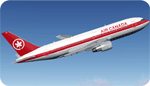
SkySpirit2010 767-200 v5. FS2004 and FSX package! Model features High resolution textures, Dynamic flexing wings, Body gear steering, Nose gear steering, Rudder lock, Ground spoilers, Low speed aileron locks at high speed, Fully animated control surfaces, Fully independent suspension, Trim Animation, Opening Passenger Doors, Animated tilting bogies, Rolling wheels, Animated thrust reverser's with reverser block doors, Detailed textures, Full night lighting, Crash affects, Ground Service Vehicles And more. Model Designer Hiroshi Igami/Yosuke Ube. Flight Dynamics Designer Warren C. Daniel. Textures by Philip Foglar. Livery by Stephen Groom
The Gimli Glider is the nickname of an Air Canada aircraft that was involved in a notable aviation incident in July 1983. On 23 July, Air Canada Flight 143, a Boeing 767-233 jet, ran out of fuel at an altitude of 41,000 feet (12,500 m) ASL, about halfway through its flight from Montreal to Edmonton via Ottawa. The crew was able to glide the aircraft safely to an emergency landing at Gimli Industrial Park Airport, a former Royal Canadian Air Force base in Gimli, Manitoba. The plane survived and flew for Air Canada until its retirement in 2008
| Filename: | Air_Canada_Gimli_Glider_Boeing_767233_CGAUN.zip |
| License: | Freeware, limited distribution |
| Added: | 3rd February 2013, 22:46:43 |
| Downloads: | 1,619 |
| Author: | Stephen Groom / Skyspirit 2010 |
| Size: | 10.59 MB |
| Category: Flight Simulator 2004 - Aircraft Repaints, Textures and Modifications | |
| US Air Metal Fuse BAC 1-11 204AF (N1127J) |
|
Images related to this file:
File Description:
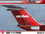
I am very proud to present this very detailed and realistic repaint of the BAC 1-11 204AF model by David Maltby in the classic US Air livery from the early 80's. This was one of the original jets flown by US Air. It flew side by side in their fleet with the B727, DC9 and 737-200. This repaint is the result of a major overhaul of the paintkit for this aircraft, and is very detailed and realistic. The many new details and hand repainted items include; custom metal fuselage, custom windows, custom tail textures, hand painted wheels, and also much needed night lighting and night textures. The US Air logo is also hand painted. All repainted textures in this package are 32-bit with no mipmaps. This repaint is dedicated to Lorne Jordan, a Canadian simmer who inspired this project and who helped Q/A this repaint so we didn't miss a detail. Thanks to the permission granted by of the gracious and talented David Maltby (creator of this aircraft model), this is a full installation package, complete with 2D panel, virtual cockpit and BAC 1-11 sounds. Please see README.TXT for installation instructions.
| Filename: | US_Air_Metal_Fuse_BAC_111_204AF_N1127J.zip |
| License: | Freeware, limited distribution |
| Added: | 5th May 2012, 07:36:27 |
| Downloads: | 850 |
| Author: | Jeffrey S. Bryner, Lorne Jordan, David Maltby |
| Size: | 21.41 MB |
| Category: Flight Simulator 2004 - Scenery | |
| CYEN Estevan Saskatchewan Municipal Airport |
|
Images related to this file:
File Description:

CYEN Estevan Municipal airport is situated approximately three miles (6 Km) north of the City of Estevan. CYEN Estevan Muni was constructed using GMAX and represents the airport as it was in the Summer of 2006. It includes all the buildings at the airport, runway signs, addition of some fencing, anda new rotating beacon that is closer to the actual device. CYEN also includes a landclass file to better represent the terrain around the airport, at least as far as the limits of the default landscape will allow.
The airport is home to Sunrise Aviation (which operates the field for the city) and some 26 light aircraft. CYEN handles a wide variety of Canadian and U.S. corporate and charter aircraft given the large oil and coal mining industry in the area. With the U.S. border so close by, CYEN is also the first stop for many U.S. registered aircraft that land to clear customs and refuel.
(This is a re-upload of the scenery to replace the original that was lost in the AVSIM hack. No changes have been made)
| Filename: | CYEN_Estevan_Saskatchewan_Municipal_Airport.zip |
| License: | Freeware |
| Added: | 7th May 2010, 12:47:13 |
| Downloads: | 1,701 |
| Author: | Gregory Putz |
| Size: | 1.67 MB |
© 2001-2026 AVSIM Online
All Rights Reserved
Privacy Policy |