
Where Flight Simulation Enthusiasts Gather from Around the World!
AVSIM Library - Search Results

| Category: Flight Simulator X - AI Flight Plans | |
| Jazz Aviation - Winter 2018/2019 |

|
Images related to this file:
File Description:

Current flight plan of Jazz Aviation for winter 2018/2019.
Jazz Aviation, commonly shortened to Jazz, is a Canadian regional airline based at Halifax Stanfield International Airport in Enfield, Nova Scotia, and is a wholly owned subsidiary of Chorus Aviation. Jazz Aviation provides regional and charter airline services in Canada and the United States, primarily under contract to Air Canada using the brand name Air Canada Express, and also as Jazz Charters.
It is Canada's third-largest airline in terms of fleet size (but not in terms of passengers carried annually, number of employees, or destinations served). Its Air Canada Express operations serve 79 destinations in Canada and the United States. Under a capacity purchase agreement, Air Canada sets the Jazz route network and flight schedule, and purchases all of Jazz’s seat capacity based on predetermined rates.
| Filename: | Jazz_Aviation__Winter_20182019.zip |
| License: | Freeware |
| Added: | 4th January 2019, 03:07:32 |
| Downloads: | 271 |
| Author: | Frank Drebing |
| Size: | 65.45 KB |
| Category: Flight Simulator 2004 - Scenery | |
| New Terrain Mesh of the Province of Quebec in LOD09 (1/4) |
|
File Description:
The files in this package contain terrain mesh files of the province of Quebec (N45 to N53) to be used with my Quebec enhanced sceneries for FS2004 (Scenes_du_Quebec_2k4.zip). The public data sources are the Shuttle Radar Topography Mission (SRTM-3, 90m) and the Canadian Digital Elevation Data (CDED - 0.75s/arc - 23m). (QC09_2k4a.zip to QC09_2k4d.zip - 4 parts)
***********************
Les fichiers de ces archives contiennent les donnees d'elevation de terrain (mesh files - lod09), pour FS2004, du territoire de la province de Quebec sous le 53ieme degre de latitude nord. Ils ont ete crees pour etre utilises avec mes nouvelles scenes du Quebec contenues dans Scenes_du_Quebec_2k4.zip. Les donnees sources sont du domaine public et proviennent de la Shuttle Radar Topography Mission (SRTM-3, 90m) et des donnees numerique d'elevation du Canada (DNEC - 0.75s/arc -23 m). (QC09_2k4a.zip to QC09_2k4d.zip - 4 parties)
| Filename: | New_Terrain_Mesh_of_the_Province_of_Quebec_in_LOD09_14.zip |
| License: | Freeware, limited distribution |
| Added: | 27th January 2010, 18:10:18 |
| Downloads: | 8,915 |
| Author: | Gilles Gauthier |
| Size: | 23.76 MB |
| Category: Flight Simulator 2004 - Scenery | |
| New Terrain Mesh of the Province of Quebec in LOD09 (2/4) |
|
File Description:
The files in this package contain terrain mesh files of the province of Quebec (N45 to N53) to be used with my Quebec enhanced sceneries for FS2004 (Scenes_du_Quebec_2k4.zip). The public data sources are the Shuttle Radar Topography Mission (SRTM-3, 90m) and the Canadian Digital Elevation Data (CDED - 0.75s/arc - 23m). (QC09_2k4a.zip to QC09_2k4d.zip - 4 parts)
***********************
Les fichiers de ces archives contiennent les donnees d'elevation de terrain (mesh files - lod09), pour FS2004, du territoire de la province de Quebec sous le 53ieme degre de latitude nord. Ils ont ete crees pour etre utilises avec mes nouvelles scenes du Quebec contenues dans Scenes_du_Quebec_2k4.zip. Les donnees sources sont du domaine public et proviennent de la Shuttle Radar Topography Mission (SRTM-3, 90m) et des donnees numerique d'elevation du Canada (DNEC - 0.75s/arc -23 m). (QC09_2k4a.zip to QC09_2k4d.zip - 4 parties)
| Filename: | New_Terrain_Mesh_of_the_Province_of_Quebec_in_LOD0.zip |
| License: | Freeware, limited distribution |
| Added: | 1st November 2009, 06:47:09 |
| Downloads: | 4,627 |
| Author: | Gilles Gauthier |
| Size: | 27.78 MB |
| Category: Flight Simulator 2004 - Scenery | |
| New Terrain Mesh of the Province of Quebec in LOD09 (3/4) |
|
File Description:
The files in this package contain terrain mesh files of the province of Quebec (N45 to N53) to be used with my Quebec enhanced sceneries for FS2004 (Scenes_du_Quebec_2k4.zip). The public data sources are the Shuttle Radar Topography Mission (SRTM-3, 90m) and the Canadian Digital Elevation Data (CDED - 0.75s/arc - 23m). (QC09_2k4a.zip to QC09_2k4d.zip - 4 parts)
***********************
Les fichiers de ces archives contiennent les donnees d'elevation de terrain (mesh files - lod09), pour FS2004, du territoire de la province de Quebec sous le 53ieme degre de latitude nord. Ils ont ete crees pour etre utilises avec mes nouvelles scenes du Quebec contenues dans Scenes_du_Quebec_2k4.zip. Les donnees sources sont du domaine public et proviennent de la Shuttle Radar Topography Mission (SRTM-3, 90m) et des donnees numerique d'elevation du Canada (DNEC - 0.75s/arc -23 m). (QC09_2k4a.zip to QC09_2k4d.zip - 4 parties)
| Filename: | New_Terrain_Mesh_of_the_Province_of_Quebec_in_LOD0.zip |
| License: | Freeware, limited distribution |
| Added: | 27th January 2010, 18:15:12 |
| Downloads: | 7,495 |
| Author: | Gilles Gauthier |
| Size: | 29.35 MB |
| Category: Flight Simulator 2004 - Scenery | |
| New Terrain Mesh of the Province of Quebec in LOD09 (4/4) |
|
File Description:
The files in this package contain terrain mesh files of the province of Quebec (N45 to N53) to be used with my Quebec enhanced sceneries for FS2004 (Scenes_du_Quebec_2k4.zip). The public data sources are the Shuttle Radar Topography Mission (SRTM-3, 90m) and the Canadian Digital Elevation Data (CDED - 0.75s/arc - 23m). (QC09_2k4a.zip to QC09_2k4d.zip - 4 parts)
***********************
Les fichiers de ces archives contiennent les donnees d'elevation de terrain (mesh files - lod09), pour FS2004, du territoire de la province de Quebec sous le 53ieme degre de latitude nord. Ils ont ete crees pour etre utilises avec mes nouvelles scenes du Quebec contenues dans Scenes_du_Quebec_2k4.zip. Les donnees sources sont du domaine public et proviennent de la Shuttle Radar Topography Mission (SRTM-3, 90m) et des donnees numerique d'elevation du Canada (DNEC - 0.75s/arc -23 m). (QC09_2k4a.zip to QC09_2k4d.zip - 4 parties)
| Filename: | New_Terrain_Mesh_of_the_Province_of_Quebec_in_LOD0.zip |
| License: | Freeware, limited distribution |
| Added: | 27th January 2010, 18:17:08 |
| Downloads: | 7,854 |
| Author: | Gilles Gauthier |
| Size: | 20.94 MB |
| Category: Flight Simulator X - Aircraft Repaints, Textures and Modifications | |
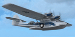
| Air-France Consolidated PBY-5A (F-BBCD) |
|
Images related to this file:
File Description:

This folder contains a repaint for the Aerosoft PBY Catalina for FSX. It is shown here in the colors of F-BBCD of Air France. F-BBCD was built by Boeing of Canada with buno 22020 as a Canso A. It served with the Canadian Air Force with registration 9791. In 1947, it was bought, with two other Canso's, by Air France, converted to carry passengers, and used in the Caribbean for flights between Fort de France and San Juan, Point a Pitre and Port of Spain. It was used until 1951, when it was sold to the Foshing Air Transport Corporation of Formosa (now Taiwan) where it was registered XT-1402 and later B-1402. It disappeared over the ocean between Matsu and Taipei on the 1st of October 1958. Repaint by Jan Kees Blom, based on the repaint kit by Aerosoft.
| Filename: | AirFrance_Consolidated_PBY5A_FBBCD.zip |
| License: | Freeware |
| Added: | 13th July 2018, 21:02:56 |
| Downloads: | 279 |
| Author: | Jan Kees Blom |
| Size: | 9.76 MB |
| Category: Flight Simulator X - Aircraft Repaints, Textures and Modifications | |
| Consolidated PBY Catalina F-BBCD |
|
Images related to this file:
File Description:
This folder contains a repaint for the Aerosoft PBY Catalina for FSX. It is shown here in the colors of F-BBCD of Air France. F-BBCD was built by Boeing of Canada with buno 22020 as a Canso A. It served with the Canadian Air Force with registration 9791. In 1947, it was bought, with two other Canso's, by Air France, converted to carry passengers, and used in the Caribbean for flights between Fort de France and San Juan, Point a Pitre and Port of Spain. It was used until 1951, when it was sold to the Foshing Air Transport Corporation of Formosa (now Taiwan) where it was registered XT-1402 and later B-1402. It disappeared over the ocean between Matsu and Taipei on the 1st of October 1958. Repaint by Jan Kees Blom, based on the repaint kit by Aerosoft.
| Filename: | Consolidated_PBY_Catalina_FBBCD.zip |
| License: | Freeware |
| Added: | 26th September 2010, 11:34:06 |
| Downloads: | 756 |
| Author: | Jan Kees Blom |
| Size: | 9.76 MB |
| Category: Flight Simulator X - Scenery | |
| Grise Fiord Airport CYGZ |
|
File Description:
Grise Fiord, NWT Canada scenery - CYGZ (FSX).
This is a fictitious rendition of the actual and VERY REMOTE Airport at Grise Fiord in the Canadian NWT - CYGZ.
Grise Fiord is the most northerly community in Canada.
Only operators with considerable experience should use this aerodrome at all. Bring your Twin Otter. There are places to fly your helocopters too. (Explore the oil rigs or see if you can land on one of the destroyers passing by).
See the whales!
See: http://www.copanational.org/PlacesToFly/airport_view.php?pr_id=13&ap_id=288
For great photo's of the area: http://www.arcticcircle.ca/Baffin/Grise/
Virtual improvements have finally come to this area where the ice never melts.
This is freeware. I hope you enjoy it.
Designed with the FS X Sdk Scenery function of the Mission builder and the Abacus Scenery shortcut tool.
This scenery is frame rate friendly.
| Filename: | Grise_Fiord_Airport_CYGZ.zip |
| License: | Freeware |
| Added: | 26th January 2007, 02:37:13 |
| Downloads: | 1,520 |
| Author: | Bob Caparoula |
| Size: | 2.47 MB |
| Category: Flight Simulator 2004 - Sounds | |
| ATC Voices - Airline Call Signs set 21 |
|
File Description:
A collection of 14 new or corrected airline callsigns, for use with
Flight Simulator 2004 or 2002. Installation requires the
EditVoicepack software
(see http://bevelstone.xs4all.nl/FlightSimulator/EditVoicepack) by Lars
Møllebjerg which is also available free download from the usual Flight
Simulator download sites such as Avsim.
The callsigns included here represent a range of airlines around the
world for which flightplans and/or aircraft are available. They are:
AEROPLUS: Aeroflot-Plus (Russian Federation),
AIR AURORA: Aurora Airlines (Singapore),
AIRMERCI: Mistral Air (Italy),
BOOKAJET: Bookajet (United Kingdom),
CARGO MAX: Maximus Air Cargo (United Arab Emirates),
CEIBA LINE: Ceiba Intercontinental (Equatorial Guinea),
CHARTRIGHT: Chartright Air (Canada),
CHINA EXPRESS: China Express Airlines (China),
EXPERT: Amira Air (Austria),
FLIGHTWORKS: Flightworks (United States of America),
LAZUR BEE-GEE: Air Lazur (Bulgaria),
OCEANSKY: Ocean Sky (United Kingdom),
THAI HAWK: Bangkok Aviation Centre (Thailand), and
TRANSPORTES PACIFICO: Aero Pacifico/Transportes Pacifico (Mexico).
| Filename: | ATC_Voices__Airline_Call_Signs_set_21.zip |
| License: | Freeware |
| Added: | 16th May 2008, 11:23:50 |
| Downloads: | 3,731 |
| Author: | John Hinson |
| Size: | 12.04 KB |
| Category: Flight Simulator 2004 - AI Aircraft | |
| Rolladen-Schneider LS-4 |
|
File Description:
This upload is one of the results of my efforts to get AI-glider traffic into FS2004.
Included are an AI-version with two textures of the Rolladen-Schneider LS-4 for flights from airfield A to airfield B, and another AI-version of the Rolladen-Schneider LS-4, tweaked in a way that it will take off from airfield A, climb while circling and then keeps endlessly circling to a max altitude of around 3000ft ASL in the surrounding of the airfield.
Credits go to Wolfgang Piper for his excellent gliders which inspired me to start experimenting with AI-gliders and for giving me permission to rebuild his gliders to AI-versions.
For other examples of his excellent gliders, visit his site http://www.fsglider.de.
Also credits go to Alan Kaiser for the stemme.air, which I used to make the AI-versions for the LS-4.
| Filename: | RolladenSchneider_LS4.zip |
| License: | Freeware, limited distribution |
| Added: | 22nd July 2005, 03:29:29 |
| Downloads: | 479 |
| Author: | Bert de Bruin |
| Size: | 812.22 KB |
© 2001-2026 AVSIM Online
All Rights Reserved
Privacy Policy |