
Where Flight Simulation Enthusiasts Gather from Around the World!
AVSIM Library - Search Results

| Category: Flight Simulator 2004 - Scenery | |
| Glacier Bay - Alaska/Canada, Version 2, Part 1 of 2 |

|
Images related to this file:
File Description:
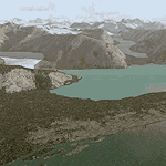
Glacier Bay v2 is a complete replacement of the default FS2004 landscape and scenery of more than 90,000 square kilometers (36,000 sq miles) of Southeast Alaska and adjacent areas of Yukon and British Columbia. File 1 of 2 (also requires glbayv2b.zip)
Landscape enhancements include high-resolution terrain mesh, detailed shorelines, rivers, lakes, and glaciers, and accurate land cover data with custom seasonal ground textures. Inland water bodies can be made to "freeze over" via an on/off switch. Other landmarks include the settlements of Juneau, Haines, Skagway, Yakutat, Atlin, and Carcross as well as road and railroad networks, cabins, lodges, and lighthouses. We modeled or enhanced 16 main airfields (plus one fictitious airstrip), 20 unlisted airstrips, 16 seaplane bases, and seven heliports. We've also included AI ship traffic in various locations as well as optional flightplans for GA and floatplane AI traffic.
Glacier Bay v2 is fully compatible with other third-party add-ons, including terrain mesh (FSGlobal, FS Genesis, etc.), ground textures (Ground Environment, BEV, FScene, etc.), and landscape enhancements (Ultimate Terrain Canada/Alaska, Misty Fjords, Tongass Fjords, Freight Dogs). A configurator panel (requires .Net Framework!) allows users to set compatibility options and to choose levels of scenery detail. We provide an autoinstaller and detailed documentation with a sectional map of the coverage area and a list of weblinks to real-world information.
For feedback and questions, please visit the Glacier Bay v2 support forum at http://forums.fsaddon.eu/viewforum.php?f=10. This project is a collaboration of nine FS developers from Germany, Austria, USA, and Canada, logging more than 1000 hours of work over the past 14 months. We acknowledge the kind support of FSAddon.com. However, this project is independent of any commercial company or product. Enjoy!
| Filename: | Glacier_Bay__AlaskaCanada_Version_2_Part_1_of_2.zip |
| License: | Freeware, limited distribution |
| Added: | 28th May 2010, 19:34:54 |
| Downloads: | 41,280 |
| Author: | Holger Sandmann, Rainer Duda, Michael Eder, Scot Fraser, Manfred Herz, Jay Langham, Jon Patch, Larry Silsbee, and Jim Vile |
| Size: | 56.46 MB |
| Category: Flight Simulator 2004 - AI Aircraft | |
| LADE-Lineas Aereas del Estado De Havilland Canada DHC-6 |
|
Images related to this file:
File Description:
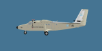
Repaint of the Henry Tomkiewicz/Project AI Twin Otter in LADE-Lineas Aereas del Estado colours. Includes files for both HTAI and Project AI versions and comes with a FSX prop texture, FS9 prop texture is included too.
| Filename: | LADELineas_Aereas_del_Estado_De_Havilland_Canada_D.zip |
| License: | Freeware |
| Added: | 14th October 2013, 20:28:59 |
| Downloads: | 392 |
| Author: | Chris Peschke,PAI |
| Size: | 269.9 KB |
| Category: Flight Simulator 2002 - Original Aircraft | |
| Qantas Link De Havilland Canada DHC-8-300 Dash 8 |
|
File Description:
FS2002 PRO - Qantas Link Dash-8 300 VH-TQY Ver 6 with full moving parts, Night effects and animated textures.
| Filename: | Qantas_Link_De_Havilland_Canada_DHC8300_Dash_8.zip |
| License: | Freeware |
| Added: | 24th June 2002, 04:24:16 |
| Downloads: | 2,103 |
| Author: | Aircraft design by Barry Blaisdell, Repainted by Stephen Newton |
| Size: | 384.15 KB |
| Category: Flight Simulator 2004 - Scenery | |
| Glacier Bay - Alaska/Canada, Version 2, Part 2 of 2 |
|
Images related to this file:
File Description:

Glacier Bay v2 is a complete replacement of the default FS2004 landscape and scenery of more than 90,000 square kilometers (36,000 sq miles) of Southeast Alaska and adjacent areas of Yukon and British Columbia. File 2 of 2 (also requires glbayv2a.zip)
Landscape enhancements include high-resolution terrain mesh, detailed shorelines, rivers, lakes, and glaciers, and accurate land cover data with custom seasonal ground textures. Inland water bodies can be made to "freeze over" via an on/off switch. Other landmarks include the settlements of Juneau, Haines, Skagway, Yakutat, Atlin, and Carcross as well as road and railroad networks, cabins, lodges, and lighthouses. We modeled or enhanced 16 main airfields (plus one fictitious airstrip), 20 unlisted airstrips, 16 seaplane bases, and seven heliports. We've also included AI ship traffic in various locations as well as optional flightplans for GA and floatplane AI traffic.
Glacier Bay v2 is fully compatible with other third-party add-ons, including terrain mesh (FSGlobal, FS Genesis, etc.), ground textures (Ground Environment, BEV, FScene, etc.), and landscape enhancements (Ultimate Terrain Canada/Alaska, Misty Fjords, Tongass Fjords, Freight Dogs). A configurator panel (requires .Net Framework!) allows users to set compatibility options and to choose levels of scenery detail. We provide an autoinstaller and detailed documentation with a sectional map of the coverage area and a list of weblinks to real-world information.
For feedback and questions, please visit the Glacier Bay v2 support forum at http://forums.fsaddon.eu/viewforum.php?f=10. This project is a collaboration of nine FS developers from Germany, Austria, USA, and Canada, logging more than 1000 hours of work over the past 14 months. We acknowledge the kind support of FSAddon.com. However, this project is independent of any commercial company or product. Enjoy!
| Filename: | Glacier_Bay__AlaskaCanada_Version_2_Part_2_of_2.zip |
| License: | Freeware, limited distribution |
| Added: | 28th May 2010, 19:36:31 |
| Downloads: | 40,552 |
| Author: | Holger Sandmann, Rainer Duda, Michael Eder, Scot Fraser, Manfred Herz, Jay Langham, Jon Patch, Larry Silsbee, and Jim Vile |
| Size: | 85.99 MB |
| Category: Flight Simulator 2004 - Scenery | |
| Frozen & Landable Lakes & Rivers for All Canada Winter Ski Operations |
|
Images related to this file:
File Description:
This "freezes" ALL Canadian lakes and rivers for winter flying and means they can be landed on with skis or wheels. This edition covers all of Canada plus parts of the USA along the border, including Michigan, Wisconsin, Minnesota, North Dakota, and Montana. It is reversible with an "untick" in the FS scenery library. I have spent some time making sure that the sea and the inlets along the coast do not get frozen too, and also some of the lakes that are close to the coast and rarely get cold enough to freeze over. Along the north shore I went for the peak of the winter with sea ice all the way to the permanent polar cap; this is not totally realistic as there is usually a partially open lead along the coast, but this would be difficult to replicate convincingly. This is really for use with Ultimate Terrain, though it will work without it. The pics show Rockcliffe in the winter with the frozen Ottawa River for real and in FS for comparison; without UT the river would not be in the right place.
| Filename: | Frozen__Landable_Lakes__Rivers_for_All_Canada_Wint.zip |
| License: | Freeware, limited distribution |
| Added: | 15th November 2010, 01:01:36 |
| Downloads: | 603 |
| Author: | Roger Wensley |
| Size: | 871.82 KB |
| Category: Flight Simulator 2004 - Scenery | |
| Red Lake (CYRL) and (CKS4) V2 Fix in Ontario, Canada |
|
Images related to this file:
File Description:
This V2 Fix adds missing textures for the town buildings around the float base CKS4; thanks to Guido, Harry, and Jens for pointing out the mising items. Unzip the textures into the CYRL texture folder, and say yes to over-write as these are ALL the building textures (I hope); this was easier than checking individual missing files. In the notes there is a further complaint from me regarding downloaders who SEE that textures are missing and then do not email me; it is easy for you to see while I cannot visually check; all my textures have to be in the main texture folder and are therefore never missing. I have to go through lists of objects and then lists of their textures.
| Filename: | Red_Lake_CYRL_and_CKS4_V2_Fix_in_Ontario_Canada.zip |
| License: | Freeware, limited distribution |
| Added: | 23rd November 2015, 14:38:56 |
| Downloads: | 271 |
| Author: | Roger Wensley |
| Size: | 22.68 MB |
| Category: Flight Simulator 2004 - Scenery | |
| Bank Farm Farm Field CF09 near Ottawa in Ontario, Canada |
|
Images related to this file:
File Description:
Bank Farm field is in Ontario and around 11 miles south and a bit east of Ottawa airport, just west of Bank Street that wriggles its way south out of Ottawa. There is a grass runway 08/26 (actually 085/265) that is 2,600 feet long, and the grass could not possibly be better. A small (and old) hangar is now only used to house the farm owner's Cessna 172 during the winter. There is a large (and also old) barn and the house is right on the approach to the runway from the east; approach 08 between the barn and the house and straightens it out on very short finals.
The hangar, barn, and house are modeled specifically for this scenery, as was the log pile.
| Filename: | Bank_Farm_Farm_Field_CF09_near_Ottawa_in_Ontario_C.zip |
| License: | Freeware, limited distribution |
| Added: | 9th February 2010, 13:36:59 |
| Downloads: | 401 |
| Author: | Roger Wensley |
| Size: | 4.13 MB |
| Category: Flight Simulator 2004 - Scenery | |
| Byron Bay CWBB plus Edinburgh Island CWEI in Nunavut, Canada |
|
Images related to this file:
File Description:
Byron Bay was a DEW line station on the south coast of Victoria Island, 105 miles east of Lady Franklin Point. It closed in 1993. The buildings are still there, slowly accumulating the patina so admired by collectors on Antiques Roadshow. The runway is just over 4,500 feet and aligned 58T-238T. At the mid point between Lady Franklin Point and Byron Bay there is a North Warning Site on the highpoint of Edinburgh Island, just south of the closed Ross Point station on the "mainland" Victoria Island. The runway is just over 1,400 feet and is also up on the top of the island. There is a steep road down 600 feet to the coast for the annual fuel resupply and maintenance.
| Filename: | Byron_Bay_CWBB_plus_Edinburgh_Island_CWEI_in_Nunav.zip |
| License: | Freeware, limited distribution |
| Added: | 11th November 2012, 21:07:05 |
| Downloads: | 246 |
| Author: | Roger Wensley |
| Size: | 2 MB |
| Category: Flight Simulator 2004 - Scenery | |
| Sproat Lake CAA9 on Vancouver Island in British Columbia, Canada |
|
Images related to this file:
File Description:
Sproat Lake is in the middle of southern Vancouver Island, 6 miles west of the town of Port Alberni and 30 miles directly south of Comox Valley Airport. It is some 14 miles long and around the eastern shores has a large number of houses with docks and boats. Plus, in the offshoot called Upper Sproat Lake, it has the Sproat Lake Tankerbase CAA9, home to two rather large Martin Mars firefighting planes. Their history is interesting, and their capacity for carrying water for dousing forest fires during the summer months has kept them in use since their construction in the 1940's. They have finally been retired from fighting fires in 2013, having been first retired from military service in 1958. This scenery is made for use with Ultimate Terrain; there was another version made several years ago which either predated or ignored UT. This scenery is for the month when a Mars was being repainted before retiring to a museum as a military plane, date unkown but perhaps 2013? If it is a time when there were three in existance then it is sometime in the 1960's; take your pick. Because of hills adjacent to the lake the landing of the AI Mars may or may not take place, depending on wind direction and whether or not it flies into rock before landing. Take off and departure seem to be more reliable than landing on a daily basis. The Mars flies to Vancouver Harbour, but only in theory; it does not land and park as there is no parking available for such a large aircraft. The AI follows in the second post.
| Filename: | Sproat_Lake_CAA9_on_Vancouver_Island_in_British_Co.zip |
| License: | Freeware, limited distribution |
| Added: | 11th December 2016, 06:44:50 |
| Downloads: | 261 |
| Author: | Roger Wensley |
| Size: | 14.88 MB |
| Category: Flight Simulator 2004 - Original Aircraft | |
| Provincial Airlines De Havilland Canada DHC-8-100 Dash 8 |
|
File Description:
FS2004 Dehavilland Dash8-Q102. A twin turboprop regional airliner. Provincial Airlines, Reg_ID: C-GPAL. An all new FSDS2.24 design
with 2D panel, Dynamic VC, and Custom Sound. In addition, a custom TCAS (Traffic Collision Avoidance System), a complete Ground
Handling module with push back and taxi speed control and the latest version GPWS (Ground Proximity Warning System) is included.
The visual model features an opening airstair with detailed cabin interior, operating Cargo Door, lift dump and roll control spoilers,
passenger wing and cabin views, and high definition reflective textures. A comprehensive set of html documents (Check List & Ref List)
are included for in-flight information. A separate Panel_Docs folder with panel and systems help files, pilot's notes and more.
| Filename: | Provincial_Airlines_De_Havilland_Canada_DHC8100_Da.zip |
| License: | Freeware, limited distribution |
| Added: | 23rd May 2005, 04:48:53 |
| Downloads: | 6,161 |
| Author: | Jean-Pierre Brisard, Barry Blaisdell, Bob May - Premier Aircraft Design |
| Size: | 21.32 MB |


© 2001-2026 AVSIM Online
All Rights Reserved
Privacy Policy |