
Where Flight Simulation Enthusiasts Gather from Around the World!
AVSIM Library - Search Results

| Category: Flight Simulator X - Original Aircraft | |
| FSX Air Canada Boeing 787-9 AGS V6 |

|
Images related to this file:
File Description:
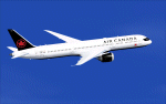
FSX Air Canada Boeing 787-9 AGS V6. Mainly the version 6 is for the new ground animations.
New animations and static display has been added from previous versions, including multiple animation effects to one object.
Aircraft cockpit featuring a new 2D panel.
Note: all CamSim aircraft models include exclusive Animated Ground Servicing (AGS) and static displays.
Model design and paint by Camil Valiquette.
| Filename: | FSX_Air_Canada_Boeing_7879_AGS_V6.zip |
| License: | Freeware |
| Added: | 17th November 2018, 00:11:03 |
| Downloads: | 230 |
| Author: | Camil Valiquette |
| Size: | 10.13 MB |
| Category: Flight Simulator 2004 - Scenery | |
| Fort Resolution CYFR in the Northwest Territories, Canada |
|
Images related to this file:
File Description:
Fort Resolution is on the south side of Great Slave Lake, 75 miles east of Hay River and just west of where the Slave River flows into the lake from Fort Smith. Fort Resolution, the oldest community in the Territories and once a vital link in the fur trade business, is a small town with a population of around 500. It was not included in the original FS9 or Ultimate Terrain so I have added it here.
The airfield is next to the town on the lakeshore. The runway is 4,000 feet of gravel with a displaced threshold at the southern (town) end; it is lit and there is PAPI. There are no scheduled flights to Fort Resolution, just occasional charters; the AI includes a stock FS9 Cessna and a Wasaya Airways PC12.
| Filename: | Fort_Resolution_CYFR_in_the_Northwest_Territories_.zip |
| License: | Freeware, limited distribution |
| Added: | 4th October 2013, 22:11:26 |
| Downloads: | 294 |
| Author: | Roger Wensley |
| Size: | 2.31 MB |
| Category: Flight Simulator 2004 - Scenery | |
| Schefferville CYKL & Squaw Lake CSZ9 in Quebec Canada |
|
Images related to this file:
File Description:
Schefferville is a town in an area of Quebec that is surrounded by Labrador, the border taking an unusual wriggly course instead of the normal Canadian straight line. One has to presume that there was a lot of political negotiation involved. Take a look at Google Earth to see what I mean. The town was established in 1954 (initially at a site a bit north of the present location, and with a different name) to support newly established iron ore mining. To assist with the exploration for further iron ore and the construction of the railway it seems that there was a forced relocation of native population. Although iron ore mining around Schefferville in its current location flourished through the late 1960's these relocated folk were neglected and suffered "destitute poverty". Through the 1970's iron ore mining declined and ceased in Schefferville in 1982, when most of the 4,000 or so non-native residents left. Since the year 2000 there have been moves to reopen mining in the area and production restarted in 2011, the approximate date of this scenery. The main reason why iron ore mining started again in Schefferville as opposed to any other area in Quebec or Labrador is the existing railway, used for ore transportation. There is no road connection and the airport is the only other means of access for the 250(?) town inhabitants. This population figure is somewhat of a guess, and the town inhabitants are largely company officers who change and move in and out as required by their work. Schefferville airport is to the east of the town. It has a single lit asphalt runway that is aligned 18-36 and is 4,975 feet long and 150 feet wide, with PAPI at both ends. Air Inuit flights connect with Kuujjuaq to the north and Sept-Isles to the south with onward connections to all parts of Canada. There are other charter flights for company personnel. The terminal building has been renovated and the photos show just how dilapidated it had become before this was done. I like it. This scenery also includes Squaw Lake, a float base that is used by Air Saguenay. Or was, as the company was closed in 2019 after an accident involving several deaths. The reason for Air Saguenay establishing a float base here was, once again, the railway, which allowed people to reach Schefferville for a reasonable cost. They could then use the float planes for a shorter distance and reasonable price to reach fishing lodges on the lakes to the north. If you find an error email me please, and note that my email address has been changed to rogwens at Gmail dot com.
| Filename: | Schefferville_CYKL__Squaw_Lake_CSZ9_in_Quebec_Cana.zip |
| License: | Freeware, limited distribution |
| Added: | 1st August 2021, 16:10:32 |
| Downloads: | 126 |
| Author: | Roger Wensley |
| Size: | 16.63 MB |
| Category: Flight Simulator 2004 - Scenery | |
| Sioux Lookout CYXL in northern Ontario, Canada, updated |
|
Images related to this file:
File Description:
This greatly modifies my previous post of Sioux Lookout; it is stand-alone and does not require you to have the 2009 version. The AI provided with the post complements what was included with Dryden (March 2013). Sioux Lookout is in northern Ontario, 40 miles east of Dryden, and 145 miles northwest of Thunder Bay. The town is on the northeastern shore of a lake that I don't know the name of (I've been there, but has anyone COUNTED how many lakes Canada has?). It has a population of around 5,000. The main businesses are lumber, tourism, and health care. The airport is immediately adjacent to the northeastern corner of the town, and has 5,300' of asphalt which is aligned 16-34. There are two taxiways which curve and climb up to the apron which is 20 or 30 feet higher. When you taxi on them the knowledge that in reality you would be climbing makes sense of the curved routing. The apron is large and a mixture of asphalt and gravel. I did not make the terminal building and I have no photo or even a recollection of what it looks like, so you should first install Northwest Ontario Airports by Eric O'Link as he has a terminal building for CYXL that might be how it looks; some of his airfields collide with other and newer versions and I have kept only his CYXL and CYPL bgl's.
| Filename: | Sioux_Lookout_CYXL_in_northern_Ontario_Canada_upda.zip |
| License: | Freeware, limited distribution |
| Added: | 19th March 2013, 19:23:24 |
| Downloads: | 405 |
| Author: | Roger Wensley |
| Size: | 5.08 MB |
| Category: Flight Simulator 2004 - Scenery | |
| Fort Smith CYSM in Northwest Territories, Canada Revised |
|
Images related to this file:
File Description:
This is an updated version to remove an incomplete static Beaver reported by Graeme (thanks Cobber) and to include other modifications that I made for my own version since posting the original; different taxiway lights, revised aprons, and in particular the revised AI that I mentioned in the original 2011 post. This is complete and can be installed as-is, or used to modify an existing post by changing the original folder contents. Fort Smith is just north of the border between Alberta and Northwestern Territories, midway between Lake Athabasca to the southeast and Great Slave Lake to the north west. You might stop there when flying between Yellowknife or Hay River to La Ronge or Saskatoon. It looks as if it is ex-military and these are the remains of what were once 10,000 feet of asphalt runways. The main runway is now 11/29 and 6,000 feet long, and the secondary one is 1,800 feet of mostly gravel. There is an airline based at the field, Northwestern Air, and fuel is available at a self service point. The town of Fort Smith is two miles east of the airfield, on the bank of the Slave River and where there are some rapids that require a portage to get around them. Before aviation came along the river was a major route to the north and all those furry animals, which was why the Hudson's Bay Company established an outpost there in 1872. Today it has a population of 2,400 and the main activities are government administration of much of the Northwest Territories, education, and tourism.
| Filename: | Fort_Smith_CYSM_in_Northwest_Territories_Canada_Re.zip |
| License: | Freeware, limited distribution |
| Added: | 23rd January 2019, 19:14:44 |
| Downloads: | 143 |
| Author: | Roger Wensley |
| Size: | 7.16 MB |
| Category: Flight Simulator 2004 - Scenery | |
| Fort Liard CYJF in the Northwest Territories, Canada |
|
Images related to this file:
File Description:
Fort Liard is the seventh in a series of airfields that follow (approximately) the Mackenzie River. At the far northern end of the river there is Tuktoyaktuk, then Inuvik, Fort McPherson, Fort Good Hope, Deline, Wrigley, and then Fort Simpson Island and Fort Simpson, all posted. Fort Liard is at 708 feet asl and on the east bank of the the Liard River, around 130 miles south of Fort Simpson where the Liard and Mackenzie join, and about 25 miles from the borders with both British Columbia and the Yukon. The town has a population of about 560 folks.
The airport is next to the town, and has almost 3,000 feet of gravel runway. I have no information regarding when it was built but it may be from the WW2 time; the cleared and grassed area is long enough for a runway 0f 6,000 feet. There are no scheduled flights but North Cariboo Air have a base at the airport for local charters to support survey teams etc. and are almost an on-demand-scheduled airline. I have also added a Buffalo DC3 and GA. There is fuel available, but only by prior arrangement with North Cariboo. Right hand circuits for runway 20.
| Filename: | Fort_Liard_CYJF_in_the_Northwest_Territories_Canad.zip |
| License: | Freeware, limited distribution |
| Added: | 11th July 2014, 13:38:49 |
| Downloads: | 301 |
| Author: | Roger Wensley |
| Size: | 10.07 MB |
| Category: Flight Simulator 2004 - Scenery | |
| Smiths Falls CYSH near Ottawa in Ontario Canada |
|
Images related to this file:
File Description:
Smiths Falls airfield is four miles east of the town of Smiths Falls and some 30 miles southwest of Ottawa. In bad visiblity it can be found by following the multiple power lines that run east-west half a mile or a mile north of the airfield. There are 45 hangars on the airfield and I have run out of time for modelling the last ten; I will get to them, but later. All of the hangars in the front line visible from the runway have been newly modeled specifically for this, along with the radio shed, gas pump shed, odds-and-ends shed, flying club office, and the new clubhouse, making 40 buildings in all. The old clubhouse burnt down in the summer of 2006, and the concrete slab is still there beside the car park. The new building cannot be anything other than an improvement.
| Filename: | Smiths_Falls_CYSH_near_Ottawa_in_Ontario_Canada.zip |
| License: | Freeware, limited distribution |
| Added: | 14th February 2010, 14:40:44 |
| Downloads: | 430 |
| Author: | Roger Wensley |
| Size: | 5.14 MB |
| Category: Flight Simulator X - Scenery | |
| Laviolette bridge, Trois-Rivières, Québec Canada for FSX |
|
File Description:
The Laviolette bridge (in French, pont Laviolette) connecting the city of Trois-Rivières and Bécancour on the South shore of the Saint Lawrence River (Highway 55) is an important land mark for pilots flying between Montreal (CYUL) and Quebec City (CYQB). It is a beautiful and aesthetic arch bridge of 2.7km long with a main span of 335m and a total height of 106,6m
A lot of attention to details was required to reproduce the bridge complex structure. This scenery features a very accurate bridge with 4 lanes traffic, night textures, road lighting and static ships. Pilots are invited the take off from nearby CYRQ airport at the control of their favourite helicopter or slow aircraft to fly around the bridge to inspect the structure and appreciate the view.
| Filename: | Laviolette_bridge_TroisRivires_Qubec_Canada_for_FS.zip |
| License: | Freeware |
| Added: | 14th March 2008, 09:22:13 |
| Downloads: | 8,093 |
| Author: | Gilles Boily |
| Size: | 1.36 MB |
| Category: Flight Simulator X - Aircraft Repaints, Textures and Modifications | |
| Air Canada "Jazz Red" BAe ATP (C-VJFJ) |
|
Images related to this file:
File Description:
FSX BAe ATP repaint textures for Air Canada's Jazz (red)
C-VJFJ. For the freeware Enigma Simulations BAe ATP
(enigma_atp_basepack.zip), which you must have previously installed in FSX.
These textures have not been tested by me in FS2004, but they will probably
work there just fine. Also includes FSX engine smoke [SMOKESYSTEM]
coordinates for your 'aircraft.cfg' file if you wish. Easy installation.
Screenshots enclosed. Repaint by Tom Tiedman.
| Filename: | Air_Canada_Jazz_Red_BAe_ATP_CVJFJ.zip |
| License: | Freeware |
| Added: | 31st March 2014, 05:10:12 |
| Downloads: | 167 |
| Author: | Tom Tiedman / Enigma Simulations |
| Size: | 9.92 MB |
| Category: Flight Simulator 2004 - AI Aircraft | |
| Winair de Havilland Canada DHC-6 (PJ-WII) |
|
Images related to this file:
File Description:
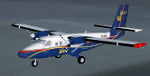
Textures only for the Winair DHC6 - PJ-WII '50th Anniversary' PAI/HTAI (Henry Tomkiewicz) base model required. DHC6.bmp & Prop-hs.bmp 32bit textures. Modified prop texture and thumbnail included. Supports FS9, FSX also P3D V2.5
| Filename: | Winair_de_Havilland_Canada_DHC6_PJWII.zip |
| License: | Freeware |
| Added: | 20th March 2015, 01:51:22 |
| Downloads: | 831 |
| Author: | Finbar Lesmond |
| Size: | 718.42 KB |


© 2001-2026 AVSIM Online
All Rights Reserved
Privacy Policy |