
Where Flight Simulation Enthusiasts Gather from Around the World!
AVSIM Library - Search Results

| Category: Flight Simulator 2004 - Scenery | |
| Boundary Bay CZBB in British Columbia, Canada |

|
Images related to this file:
File Description:
Boundary Bay is south of Vancouver in British Columbia, close to the US/Canada border. It is the 5th busiest airfield in Canada measured in terms of take offs and landings as there are several training companies based there. The airfield was purchased by Alpha Aviation in 2009 and and modernised for the 2010 Winter Olympics, the main addition being a new terminal. This is an ex-military training base which was built in 1941, and one of the original hangars still survives. The two runways in use now (07/25 5,600' and 12/30 2,750', both of them 100' wide) are reduced asphalted areas of the original runways; the third runway is now an apron for GA parking and has had hangars built along it. There is JetA and 100LL available. The large building at the east end of the north apron is a HQ and maintenance facility for a helicopter company, Heli-one. All of the north apron buildings on the field have been modelled specifically for this scenery, plus the nearby huge greenhouse farm structures which are visible from further away than the airfield is. AI for Boundary Bay will be posted later this week.
| Filename: | Boundary_Bay_CZBB_in_British_Columbia_Canada.zip |
| License: | Freeware, limited distribution |
| Added: | 12th May 2011, 13:30:18 |
| Downloads: | 855 |
| Author: | Roger Wensley |
| Size: | 4.4 MB |
| Category: Flight Simulator 2004 - Scenery | |
| Fort Nelson CYYE in British Columbia, Canada |
|
Images related to this file:
File Description:
Fort Nelson is close to the Peace River in the northeast corner of British Columbia, around 70 miles from the northern border, 90 from the eastern border, and 80 miles east of the Rockies. The wartime construction of the Alaska Highway actually started from Fort Nelson, as there was already a road from Fort St John (which is close to Dawson Creek) north to Fort Nelson. The airfield was part of this construction effort and after the wartime ferrying of planes to Russia it was used by the US Army Air Force and then by the Canadian Air Force. Fort Nelson flourished with the oil and gas exploration of the 1950's and the following years, and this continued to grow until the collapse of the oil price in 2014.
The town of Fort Nelson became the capital of the Northern Rockies Regional District when it was founded in 2009, and as a result the official name of the Fort Nelson airport is the Northern Rockies Regional Airport. The date for this scenery is around 2016, by which time the economic fortunes of the town were in decline. Five times per day flights by Central Mountain Air were starting to be reduced in number to the current (in 2022) one per day and none on Sunday; in the AI included here there are two flights per day. The main resident users of the airport are four helicopter companies, the helicopters presumably used for maintenance trips to whatever parts of the oil and gas fields that are still in use in the surrounding area.
There are two runways, the main one is aligned 03-21, 6,400 feet long and 200 feet wide, with ILS at the southern end and PAPI at the northern. The second runway (a narrower rebuild on a previously existing runway) is aligned 07-25 and 77 feet wide, and is without any lights. These are the alignments as per the original build of FS9 and not as per the approximate 2016 date of the buildings; I had a problem at a very late stage in making this scenery which prevented me from continuing with some final details.
On YouTube there is a series of posts by Angle of Attack showing the preparation and then the flight of an old Cessna 172 from Homer to Oshkosh for the installation of modern instruments. Interesting for me as they visit or fly over airfields I have made (Homer, Merrill, Tok Junction, Burwash, Silver City, Haines Junction, Watson Lake, Fort Nelson, and Grande Prairie) but in the winter so it all looks very different.
| Filename: | Fort_Nelson_CYYE_in_British_Columbia_Canada.zip |
| License: | Freeware, limited distribution |
| Added: | 23rd January 2022, 20:11:18 |
| Downloads: | 187 |
| Author: | Roger Wensley |
| Size: | 28.35 MB |
| Category: Flight Simulator 2004 - Scenery | |
| Anahim Lake CAJ4 in British Columbia, Canada |
|
Images related to this file:
File Description:
Anahim Lake is around 55 miles east of Bella Coola by air, and clear of the deep and rugged valley that connects the two with a road that is over 75 miles long. The two are also linked by a daily Pacific Coastal flight. A further 150 miles east is Williams Lake (200 miles by road). The town of Anahim Lake is small, but renowned for numerous surrounding fishing lodges on the lakes and the enjoyment of "nature" in what is known as the Chilcotin Wilderness. The Anahim Lake airport is an odd one. It appears to have fallen into disuse over a period of years, but is now in the process of being upgraded, with some new hangars (though oddly situated, and with only dirt track taxiway access) and a recently completed terminal building. There is also a plan to upgrade the runway (lights etc, there are currently no runway or taxiway lights) and in general to greatly improve the facilities on offer. The only current airline to fly there is Pacific Coastal. The runway is just under 4,000 feet of asphalt aligned 13-31 and 75 feet wide. There used to be another runway which is still visible but is now unusable, gravel that has not been maintained for several years. The notes for Anahim Lake airfield in the Nav Canada manual warn of "Extensive float plane activity at Nimpo Lake to the south" and of "possible large animals within the airport perimeter". Nimpo Lake activity will follow in further posts.
| Filename: | Anahim_Lake_CAJ4_in_British_Columbia_Canada.zip |
| License: | Freeware, limited distribution |
| Added: | 29th November 2018, 19:21:59 |
| Downloads: | 153 |
| Author: | Roger Wensley |
| Size: | 5.72 MB |
| Category: Flight Simulator 2004 - AI Aircraft | |
| West Atlantic (Atlantic Airlines) British Aerospace ATP |
|
Images related to this file:
File Description:

West Atlantic (Atlantic Airlines) 'White' livery repaint for the PAI Bae ATP FS9 model. Model available separately. Also contains .dds textures for FSX users.
| Filename: | West_Atlantic_Atlantic_Airlines_British_Aerospace_.zip |
| License: | Freeware |
| Added: | 13th September 2015, 22:06:47 |
| Downloads: | 527 |
| Author: | Chris Baker |
| Size: | 689.12 KB |
| Category: Flight Simulator 2004 - Scenery | |
| Cache Creek CAZ5 in British Columbia Canada |
|
Images related to this file:
File Description:
Cache Creek is a small village of around 1,000 folks on the eastern side of the Coast Mountains of British Columbia, around 70 miles northeast of Pemberton and 40 miles west of Kamloops. The village is in a valley bottom and recently suffered from severe flooding due to the overflow of the river. The airfield is high above the town, with a runway aligned 15-33 and 3,280 feet of asphalt, without runway or taxiway lighting; hence "airfield" as opposed to "airport". I have posted it as Cache Creek CAZ5, but I suggest that you revise the name to perhaps "BC airfields" and just load my future airfield posts into the same scenery and texture folders to avoid the inevitable doubling up of common textures etc. Plus that way you will have just one FS9 library post to do and new airfields will not need yet another posting. Up to you. If you find a defect, email me.
| Filename: | Cache_Creek_CAZ5_in_British_Columbia_Canada.zip |
| License: | Freeware, limited distribution |
| Added: | 18th November 2020, 01:21:22 |
| Downloads: | 96 |
| Author: | Roger Wensley |
| Size: | 9.27 MB |
| Category: Flight Simulator 2004 - Scenery | |
| Prince George CYXS in British Columbia, Canada |
|
File Description:
Prince George is centrally located in British Columbia, mid way between the border with the USA in the south and the northern border with the Northern Territories, and around 100 miles west of the eastern border with Alberta. The town now has a population of around 74,000 and is regarded as the province's northern capital. It is at the meeting point of the Fraser and Nechako rivers and the crossroads of highways 16 and 97. It started out as Fort George in the early 1800's when a trading post was established by the Northwest Company,serviced by paddle boats on the rivers. The railway arrived in the area in 1914 and growth continued, albeit slowly due to wars and the financial collapse of the 1930's. Timber and timber products were and still are the mainstay of the area, along with a military and governmental presence.
The date for this scenery is around 2010. I have made some new buildings from memory and the available information online. They are not totally accurate reproductions; for instance I know that the terminal building is brick faced and also has parts that are stone (or metal?) faced, but where? So I used brick everywhere. The control tower is also brick faced, but is not exactly the right shape. The airport management team have continued to grow the activity and services provided with the result that flights and passenger numbers continue to increase. The 15-33 runway was lengthened to the south, (in the period 2003 to 2005) from the original FS9 scenery 7,400 feet to my updated 11,450 feet with central lighting and ILS at the northern end. This made it the third longest runway in Canada. At the same time a loading/unloading cargo area was created with professionally run storage and also a large scale refueling storage. If DHL want to refuel their 737 then they can do so without making prior arrangements.
The AI included here is for Air Canada Jazz and an Air Canada 737, Westjet 737 and Dash8, a helicopter company that is based there, Pacific Coastal, Central Mountain Air, and GA. The range of airlines and planes reflects the "northern capital" status of the town.
| Filename: | Prince_George_CYXS_in_British_Columbia_Canada.zip |
| License: | Freeware, limited distribution |
| Added: | 11th November 2022, 23:10:19 |
| Downloads: | 160 |
| Author: | Roger Wensley |
| Size: | 28.04 MB |
| Category: Flight Simulator 2004 - AI Flight Plans | |
| bmi British Midland International Summer 2011 v2 |
|
Images related to this file:
File Description:

This is part of our flightplans for the Summer 2011 season. The team aims to provide high quality flightplans for the FS community. Each flightplan has been tested using many resources, and our goal is to make a realistic representation of each airline's route network. Visit us at www.alpha-india.net for more information. This v2 includes the EGPF airport info that was missing in the initial release.
| Filename: | bmi_British_Midland_International_Summer_2011_v2.zip |
| License: | Freeware |
| Added: | 23rd July 2011, 17:57:06 |
| Downloads: | 2,016 |
| Author: | Ben MacDougall & Alpha India Group |
| Size: | 23.95 KB |
| Category: Flight Simulator X - Aircraft Repaints, Textures and Modifications | |
| 1 Sqn RAF British Aerospace Harrier (ZD352) |
|
Images related to this file:
File Description:
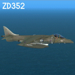
This repaint has been made for the RAZBAM Harrier GR7 / GR9 with the use of their paintkit with a few modifications.
Repaint is of ZD352 tailcode 01 flown by 1Squadron RAF in the early 90's .
| Filename: | 1_Sqn_RAF_British_Aerospace_Harrier_ZD352.zip |
| License: | Freeware |
| Added: | 22nd January 2014, 01:33:34 |
| Downloads: | 247 |
| Author: | John Glanville / Razbam |
| Size: | 11.35 MB |
| Category: Flight Simulator 2004 - Original Aircraft | |
| British Mediterannean Airbus 320-232 'Whale Rider' |
|
File Description:
iFDG is proud to present the Airbus A320. The aircraft model includes most of the standard features including animated control surfaces, wingviews, flaps, full lighting configuration, highly detailed, reflective textures, and dynamic shine. This example is painted in the Whale Rider (Canada) livery of British Mediterannean (G-MEDA). Please read the included readme file for more information and repaint info. Updated V1.3 Model Included.
| Filename: | British_Mediterannean_Airbus_320232_Whale_Rider.zip |
| License: | Freeware, limited distribution |
| Added: | 9th June 2004, 19:37:11 |
| Downloads: | 6,587 |
| Author: | Ben Jones, iFDG |
| Size: | 6.31 MB |
| Category: Flight Simulator 2004 - AI Aircraft | |
| Ansett Air Freight British Aerospace 146-200QT |
|
File Description:
FMAI British Aerospace 146-200QT Ansett Air Freight textures.
Textures in DXT3 format and tails color matched to compliment existing models by Ivan Doey and Vladko Fejes.
Textures are as close as my ability (and currently available information I have) can get to the actual design used by Ansett Air Freight at the time.
I Hope you like them :-)
| Filename: | Ansett_Air_Freight_British_Aerospace_146200QT.zip |
| License: | Freeware, limited distribution |
| Added: | 19th July 2007, 12:07:54 |
| Downloads: | 252 |
| Author: | Matthew Rattray |
| Size: | 294.55 KB |


© 2001-2026 AVSIM Online
All Rights Reserved
Privacy Policy |